

Snowy Hibbo
-
Posts
30 -
Joined
-
Last visited
About Snowy Hibbo

Recent Profile Visitors
995 profile views


-
In my winter forecast, I have found for an average to slightly above average winter in terms of snowfall for the Mid Atlantic. Based upon the possibility for a SSW, some positive analogs for ENSO and QBO, decent pre-season snow cover, etc. https://longrangesnowcenter.net/2020/12/06/north-america-winter-outlook-2020-21/
-
The not so bad climatic driver conditions for ENSO and QBO and the potential for a SSW show me potential for a pretty nice winter for New England in my latest winter outlook https://longrangesnowcenter.net/2020/12/06/north-america-winter-outlook-2020-21/
-
https://longrangesnowcenter.net/2020/10/20/october-preliminary-2020-21-winter-outlook/ An interesting splash of factors, for the Eastern US, a few shifts (particularly on ENSO) from last time I dropped in: A basinwide moderate (possibly strong) La Nina this winter. A positive QBO Solar Minimum Atlantic SSTs favourable for a +NAO North Pacific SSTs favourable for a Aleutian Ridge. Average growth of Stratospheric Polar Vortex into winter, potential for SSWs later. Phase 3-6 MJO centred tropical base state Low sea ice in Barents-Kara Sea. Average snow coverage in Siberia. Looking pretty average in terms of snowfall for the Mid Atlantic IMO.
-
https://longrangesnowcenter.net/2020/10/20/october-preliminary-2020-21-winter-outlook/ An interesting splash of factors, for the Eastern US, a few shifts (particularly on ENSO) from last time I dropped in: A basinwide moderate (possibly strong) La Nina this winter. A positive QBO Solar Minimum Atlantic SSTs favourable for a +NAO North Pacific SSTs favourable for a Aleutian Ridge. Average growth of Stratospheric Polar Vortex into winter, potential for SSWs later. Phase 3-6 MJO centred tropical base state Low sea ice in Barents-Kara Sea. Average snow coverage in Siberia. Looking at a slightly above average snowfall season for New England IMO.
-
2019 ENSO
Snowy Hibbo replied to AfewUniversesBelowNormal's topic in Weather Forecasting and Discussion
Putting together an analog for a moderate-strong Nina winters since the 1980s, based in the Eastern Pacific extending into the entire basin: Troughing/low pressure in the Eastern Indian Ocean and over Maritime Continent, certainly goes with the idea of a strong tropical standing wave over Maritime Continent. Strong Aleutian Ridge, supports snowfall and cold in Northern America and Canada. Less North Pacific Jet extensions, less atmospheric rivers. A very weak -NAO and more obvious Scandinavian blocking, which may help support snowfall and cold in Southern Europe/UK. Decent troughing of east of Japan versus strengthened Siberian blocking, which supports Japanese snowfall. We certainly see ECMWF go with a positive Equatorial Southern Oscillation, that matches with an atmospheric Nina going forward. So there is a case for seeing a proper atmospheric Nina....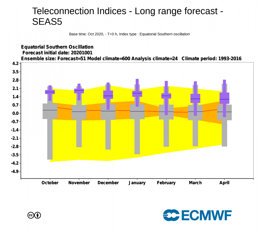
-
Certainly at this very moment, it looks basinwide, but the forecasts I am seeing for winter and base my preliminary analysis upon (specifically EC) are looking at a more CP Nina (cooling shifts away from ENSO 1+2).
-
My first seasonal prediction for the NH this season: https://longrangesnowcenter.net/2020/09/06/early-september-seasonal-2020-21-winter-preliminary-outlook/ Western & Central US and the Northern Alps to benefit from a Canadian Vortex/Aleutian High and +NAO driven weather outlook for the winter ahead from the preliminary look of factors (still got more to look at in coming weeks...). Not looking so good for the Eastern US under this pattern, climatic factors not stacking up well for the Mid-Atlantic.
-
G’day everyone, My first seasonal prediction for the NH this season: https://longrangesnowcenter.net/2020/09/06/early-september-seasonal-2020-21-winter-preliminary-outlook/ Western & Central US and the Northern Alps to benefit from a Canadian Vortex/Aleutian High and +NAO driven weather outlook for the winter ahead from the preliminary look of factors (still got more to look at in coming weeks...). Not looking as great for the Eastern US, could be okay for New England (compared to the Mid-Atlantic).
-
2019 ENSO
Snowy Hibbo replied to AfewUniversesBelowNormal's topic in Weather Forecasting and Discussion
Just an extract from my early seasonal update about ENSO, thought the analog might interest some. Text not entirely relevant to the US, worthy of note on the analog is the SE ridge that comes along with it. -
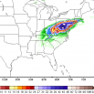
https://longrangesnowcenter.net/2019/12/30/north-america-on-the-long-term-30th-december/ Looking like a decent chance of snowy weather for the region around the 6th-9th of January, then ridging through mid-January. Potential for more snowfall in early February, per the pattern cycle. More details on the drivers and analysis above
-
Snowy Hibbo changed their profile photo
-
2019 ENSO
Snowy Hibbo replied to AfewUniversesBelowNormal's topic in Weather Forecasting and Discussion
It’s interesting that those SOI drops occurred while the MJO phase/signal was still over Maritime Continent. You could certainly argue a Nino-esque tropical atmosphere at least at the surface, because that’s certainly not how it is panning out in the extratropics, with a lack of momentum being quite obvious in the GSDM.


