

StormChazer
-
Posts
1,231 -
Joined
-
Last visited
Content Type
Profiles
Blogs
Forums
American Weather
Media Demo
Store
Gallery
Everything posted by StormChazer
-

MO/KS/AR/OK 2022-2023 Winter Discussion
StormChazer replied to JoMo's topic in Central/Western States
A boy can dream. Still, I'm liking the trend. -
MO/KS/AR/OK 2022-2023 Winter Discussion
StormChazer replied to JoMo's topic in Central/Western States
These are my favorite types of storms, when they start to trend big under a week out. So often we sit in la la land with dream scenarios on the models and then at a week we get brough back to reality. So here's to hoping this westward trend continues. -
MO/KS/AR/OK 2022-2023 Winter Discussion
StormChazer replied to JoMo's topic in Central/Western States
Here is that storm isolated. FWIW, Tuttle started to pick up on this last night with the UKMET and Icon and now the Euro is beginning to shift west as well on this. If we keep going, this definitey has some high snow amount potential and would definitely equate to a white Christmas for most of us. -
MO/KS/AR/OK 2022-2023 Winter Discussion
StormChazer replied to JoMo's topic in Central/Western States
-
MO/KS/AR/OK 2022-2023 Winter Discussion
StormChazer replied to JoMo's topic in Central/Western States
Euro is finally starting to come around. Last night's run vs this afternoon's. -
MO/KS/AR/OK 2022-2023 Winter Discussion
StormChazer replied to JoMo's topic in Central/Western States
I'll post the Euro ensembles today after the noon run comes out. Here is the GFS members for this 1st upcoming storm system. Probability of 1 inch or more of snow, last nights run compared to today's noon run. -
MO/KS/AR/OK 2022-2023 Winter Discussion
StormChazer replied to JoMo's topic in Central/Western States
12Z GFS snow totals for the curious Canadian paints a similar, but much less robust picture. -
MO/KS/AR/OK 2022-2023 Winter Discussion
StormChazer replied to JoMo's topic in Central/Western States
GFS hanging onto this small snow "storm" on the 20th. -
MO/KS/AR/OK 2022-2023 Winter Discussion
StormChazer replied to JoMo's topic in Central/Western States
Well that GFS run was MUCH less fun. -
MO/KS/AR/OK 2022-2023 Winter Discussion
StormChazer replied to JoMo's topic in Central/Western States
Could you imagine this 6AM Christmas morning? Of course, that requires getting 2 feet of snow, but I digress. -
MO/KS/AR/OK 2022-2023 Winter Discussion
StormChazer replied to JoMo's topic in Central/Western States
I second this. Really liking that all the major models have snow in them, not necesarily at the same times and amounts, but it's there. -
MO/KS/AR/OK 2022-2023 Winter Discussion
StormChazer replied to JoMo's topic in Central/Western States
Euro sniffing out the same storm as the GFS on the 22nd. -
MO/KS/AR/OK 2022-2023 Winter Discussion
StormChazer replied to JoMo's topic in Central/Western States
I feel like I shouldn't even bother looking at the models until we are 4 days out right now, they just are all over the place with no consistency. Hopefully we can start getting some run to run consistency and multiple models agreeing on the same thing. -
MO/KS/AR/OK 2022-2023 Winter Discussion
StormChazer replied to JoMo's topic in Central/Western States
Obviously we can only take away some broad generalizations this far out, but colder and possibly a favorable pattern for storms around the last couple weeks in December is the best you can ask for at this stage of the game. -
MO/KS/AR/OK 2022-2023 Winter Discussion
StormChazer replied to JoMo's topic in Central/Western States
I'll take the last 60 hours of the 12Z GFS please. -
MO/KS/AR/OK 2022-2023 Winter Discussion
StormChazer replied to JoMo's topic in Central/Western States
Was unlucky last night here in the Owasso/Collinsville area. Broken Arrow picked up close to half an inch, but nothing but rain here in Owasso. Odd to think I'd need to drive south to encounter the snow, not north! -
MO/KS/AR/OK 2022-2023 Winter Discussion
StormChazer replied to JoMo's topic in Central/Western States
NAM has trended snowier the past few runs. Gives NW AR a nice 3-4 inches. All depends on where those bands set up as the system moves overhead, hard to predict those.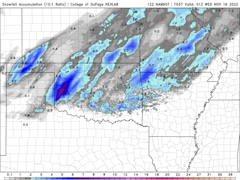
-
MO/KS/AR/OK 2022-2023 Winter Discussion
StormChazer replied to JoMo's topic in Central/Western States
Yes please. -
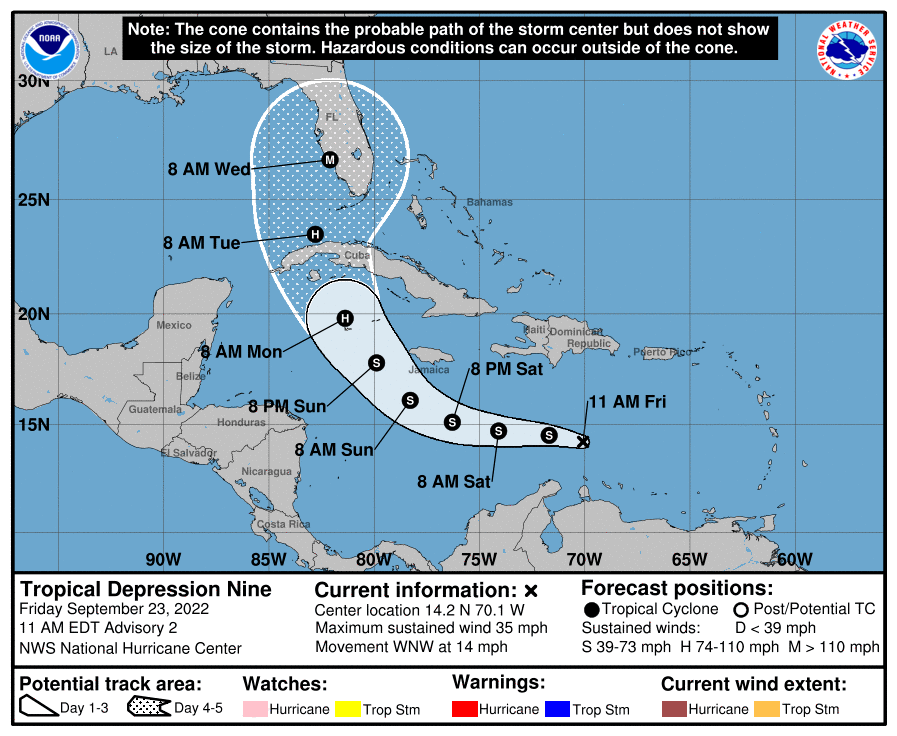
I mean give credit where credit is due. I know this path susequently moved around after this, but this was spot on right here.
-
Honestly, the very first advisory they issued was really.....spot on..like, almost to the exact point of landfall.
-
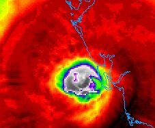
Even has an "I" in the eye...
-
Why should someone else have to risk their lives to save you if you get swept away by your stupidity? You deserve whatever consequences come from those actions, that's all I'm going to say.
-
I have some in laws in Tampa, and back when they were in it's sight, they said, "I think we are prepared, so we will ride it out, if not we will drive inland and find a hotel". People just don't get that by the time you've gauged that it's getting too bad to stay, it's even worse on the roads. Anyways, to stay on topic and not banter too much, you can see the eye on IR really opening up in the last hour, not great timing. Cat 5 or not, it doesn't matter at this point in terms of actual damage, it's past the point of no return now.
-
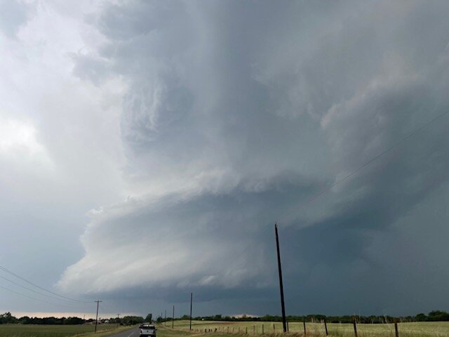
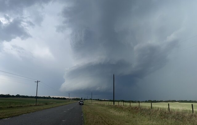
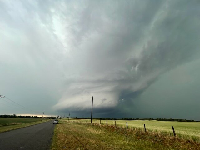
I started out in Enid, and blasted south to catch this supercell in Dover, OK before it was absorbed into the line. Then went south to the storm SW of OKC. Follow it from Blanchard to Purcell before giving up on it and going back home to Tulsa. I guess if I stayed with it another 45 min I could have caught the Seminole tornado, but hindsight is 20/20.
-
I'll be driving out toward Enid from Tulsa here in about an hour and a half.

