StormChazer
-
Posts
1,231 -
Joined
-
Last visited
Content Type
Profiles
Blogs
Forums
American Weather
Media Demo
Store
Gallery
Everything posted by StormChazer
-

MO/KS/AR/OK 2021-2022 Winter Discussion
StormChazer replied to JoMo's topic in Central/Western States
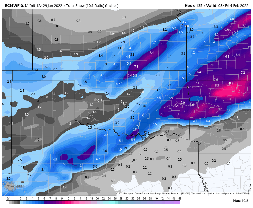
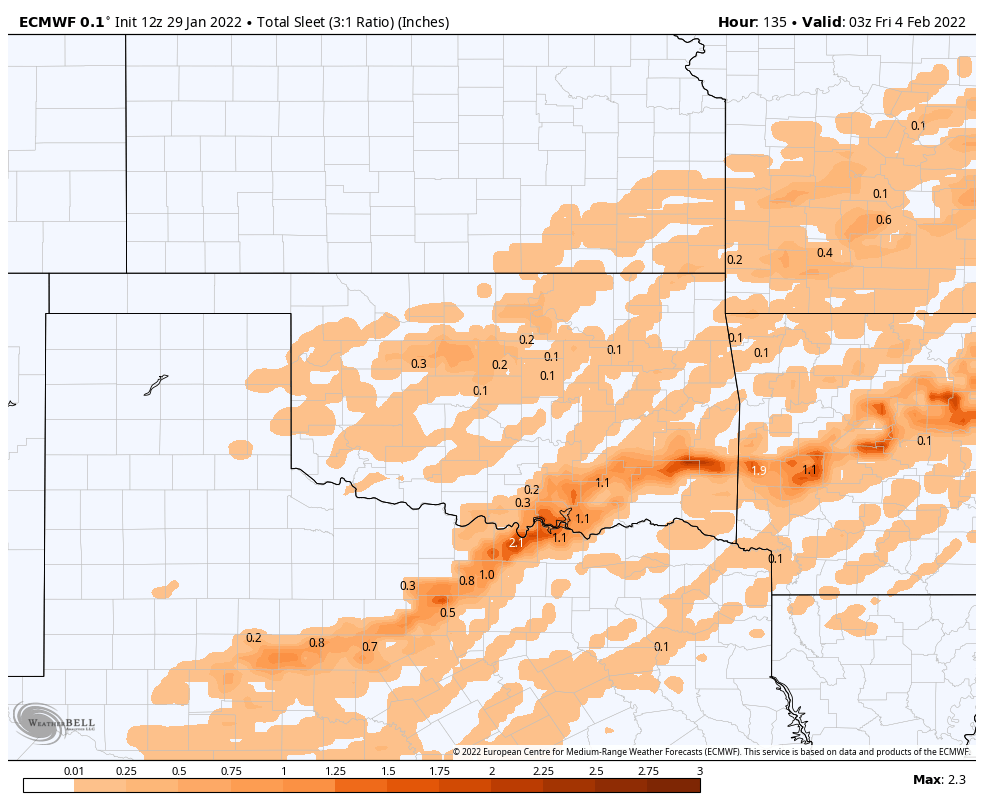
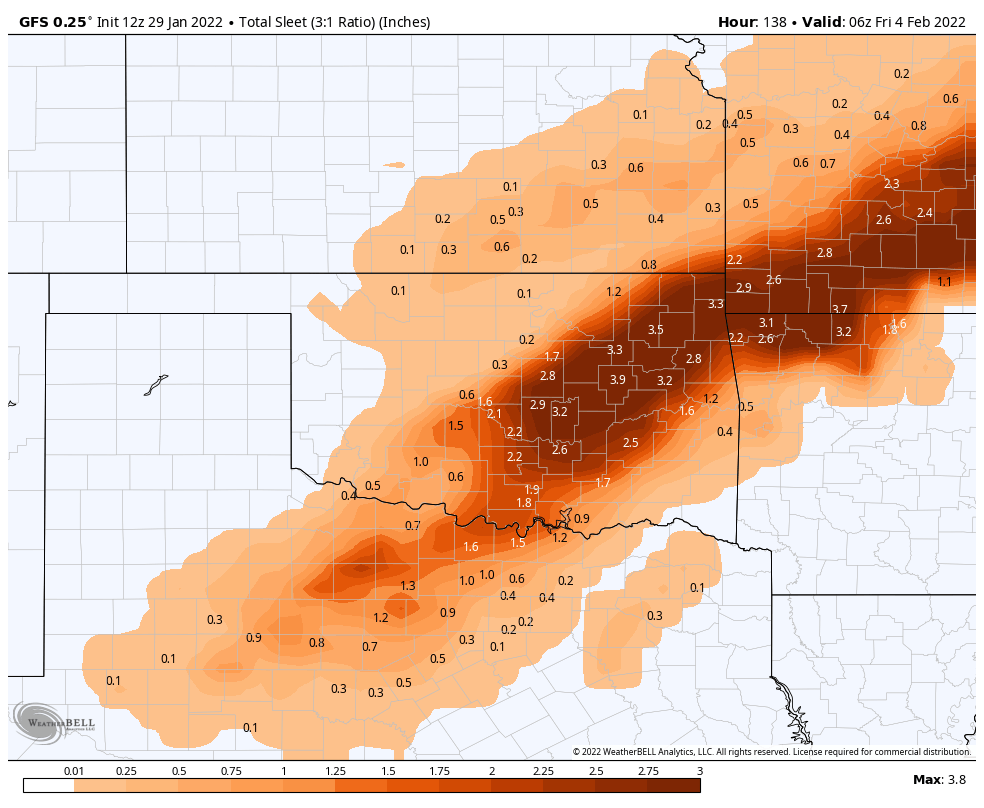
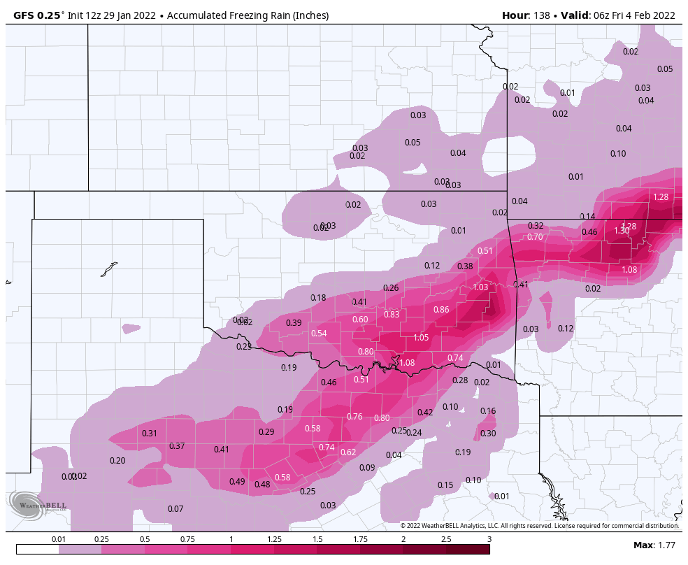
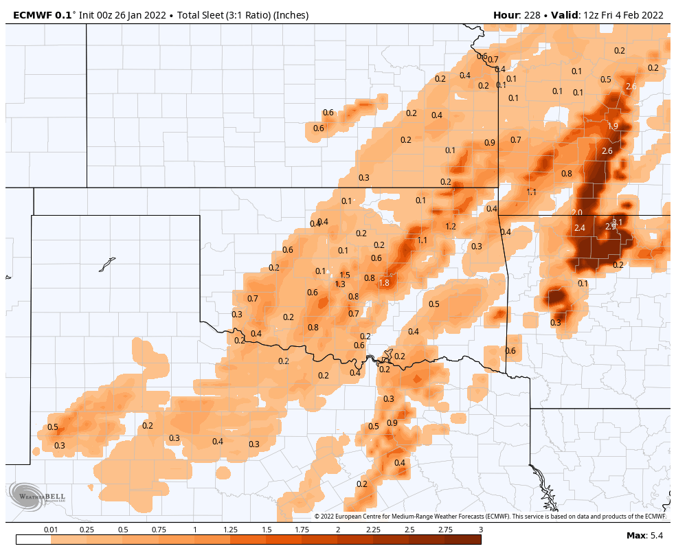
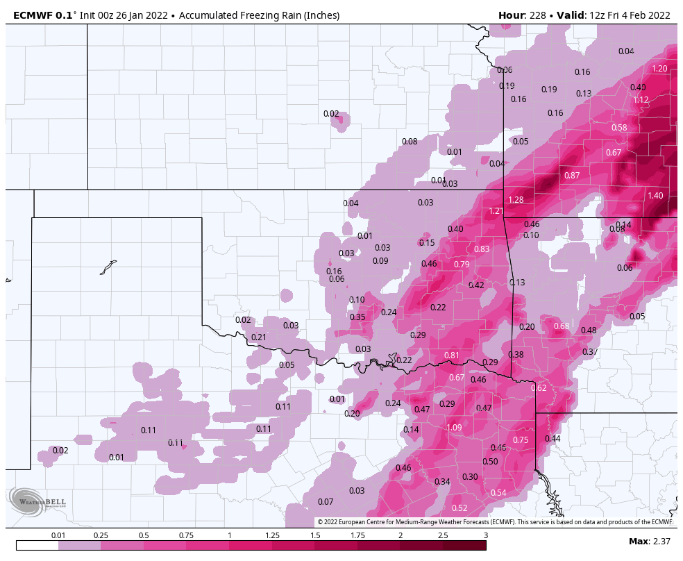
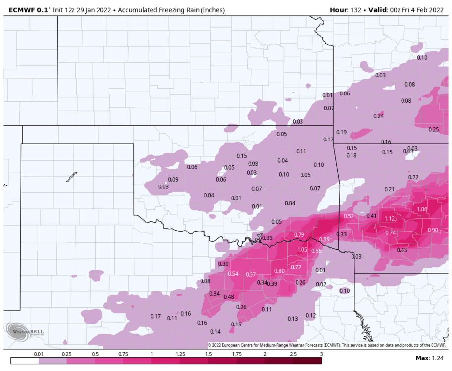
I know we can't get fixated on the numbers.....but the trend with all the models is that this has the potential to be an EXTREMELY impactful winter storm with cold air behind it. Do you know what 4-5 inches of sleet does to a city when it takes 3-4 days to melt? I lived in DFW in 2013 during the "Cobblestone Ice' event. It dropped 5 inches of sleet on us....the roads become a virtual ice skating rink the first day. But then, as cars drive on it, they naturally melt "potholes" into the thick sheet of sleet, and then refreezes, which causes your car to slide in and out of these bumps and holes, making driving quite literally impossible, no matter the car. Now that I'm done overhyping this and acting like it's the end of the world. Let's come back down to reality. That was an insanely rare event, and the models have so much trouble with the thickness of cold air, that this could(hopefully) just be a quick transition to snow from some freezing rain and sleet. But we have to take the trends seriously, it's only 4 days out now. Weenie rant over. -
MO/KS/AR/OK 2021-2022 Winter Discussion
StormChazer replied to JoMo's topic in Central/Western States

-
MO/KS/AR/OK 2021-2022 Winter Discussion
StormChazer replied to JoMo's topic in Central/Western States
Well I’m in between the high totals of the GFS and the EURO, so if they can meet in the middle I’m set. -
MO/KS/AR/OK 2021-2022 Winter Discussion
StormChazer replied to JoMo's topic in Central/Western States
Full blown winter storm. 4 inches of sleet followed by super cold temps? Roads would be impassable for days.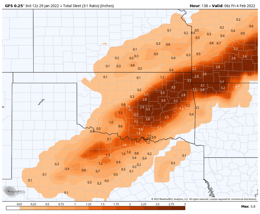

-
MO/KS/AR/OK 2021-2022 Winter Discussion
StormChazer replied to JoMo's topic in Central/Western States
GFS is thrashing Tulsa with an ice storm. -
MO/KS/AR/OK 2021-2022 Winter Discussion
StormChazer replied to JoMo's topic in Central/Western States
This is as far out as it goes.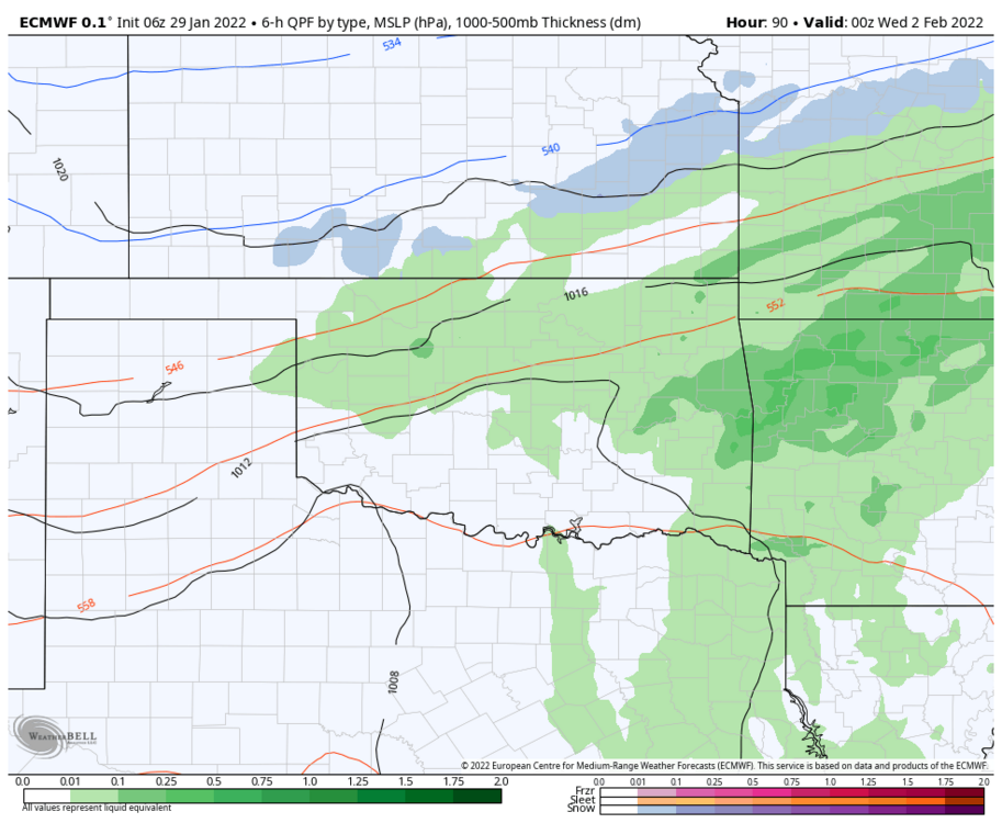
-
MO/KS/AR/OK 2021-2022 Winter Discussion
StormChazer replied to JoMo's topic in Central/Western States
All Good trends overnight with the three major players. Ice storm is definitely looming over the area. North Texas gets hammered as well. Time to see what the afternoon runs show! -
MO/KS/AR/OK 2021-2022 Winter Discussion
StormChazer replied to JoMo's topic in Central/Western States
I'm not sure...These systems that pull pacific moisture in from the SW are harder to predict due to the sparse sampling system in place down there.. By the time we can sample it, it's already on our doorstep. But maybe someone with more knowledge than me can enlighten us! -
MO/KS/AR/OK 2021-2022 Winter Discussion
StormChazer replied to JoMo's topic in Central/Western States
I don't believe there is one. You have to look at the soundings to extrapolate the precip type from there. -
MO/KS/AR/OK 2021-2022 Winter Discussion
StormChazer replied to JoMo's topic in Central/Western States
-
MO/KS/AR/OK 2021-2022 Winter Discussion
StormChazer replied to JoMo's topic in Central/Western States
TSA on next week. "Deep cyclonic flow is expected to develop over the western 2/3rds of the CONUS toward the middle of next week. Another arctic air invasion is expected as this occurs as surface high pressure, with origins near the Yukon and Northwest Territory, comes clear down into the northern CONUS. The concomitant arctic front will likely precede the passage of the upper wave axis, leading to a plethora of potential issues. Along/ahead of the front, some data is painting an axis of locally heavy rainfall which could be over far eastern OK into western AR or just slightly to the east. Then, as the cold air spills south with the front, a wintry mix is expected with ice, sleet and snow accums possible. The GFS remains on the drier side overall regarding the amount of precip back in the cold air vs the ECMWF. Thus, the details are likely to change and will continue to be refined in the coming days. Stay tuned." Lacy -
MO/KS/AR/OK 2021-2022 Winter Discussion
StormChazer replied to JoMo's topic in Central/Western States
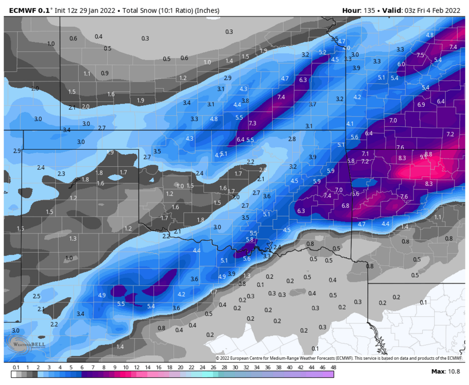
The actual Euro run, just to come down to earth. -
MO/KS/AR/OK 2021-2022 Winter Discussion
StormChazer replied to JoMo's topic in Central/Western States
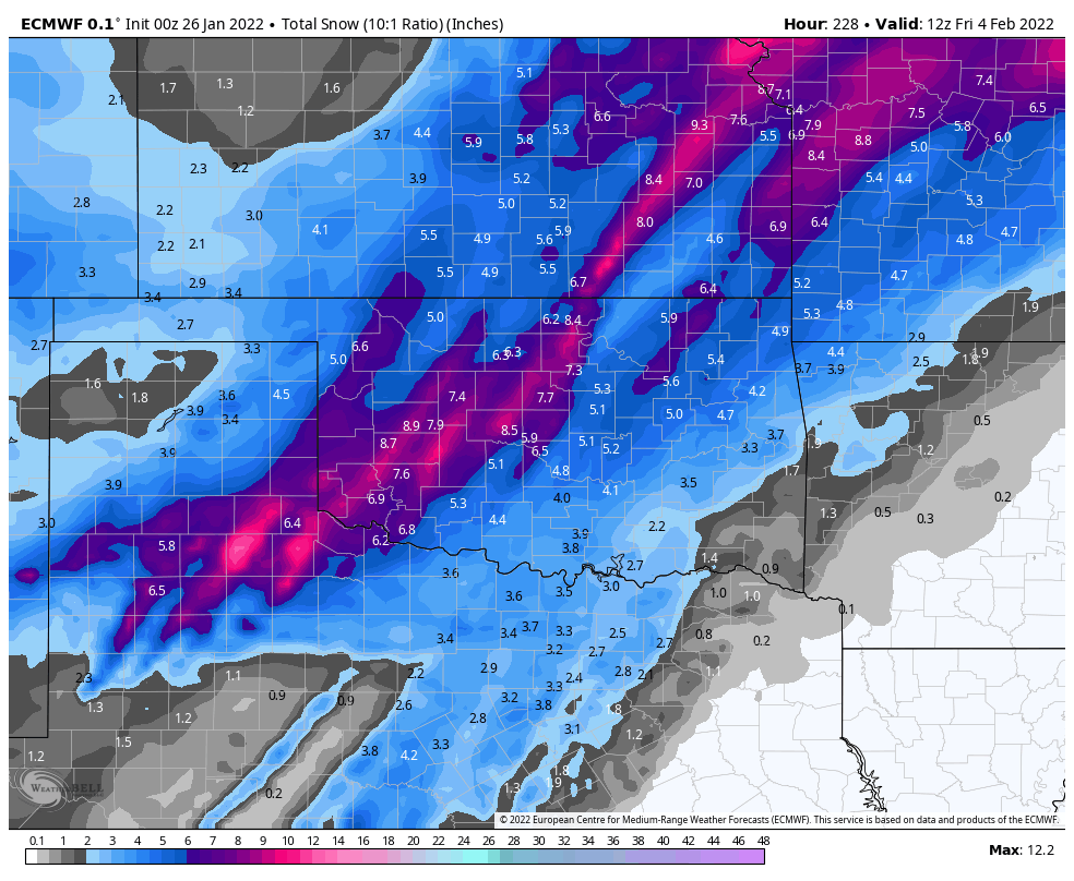
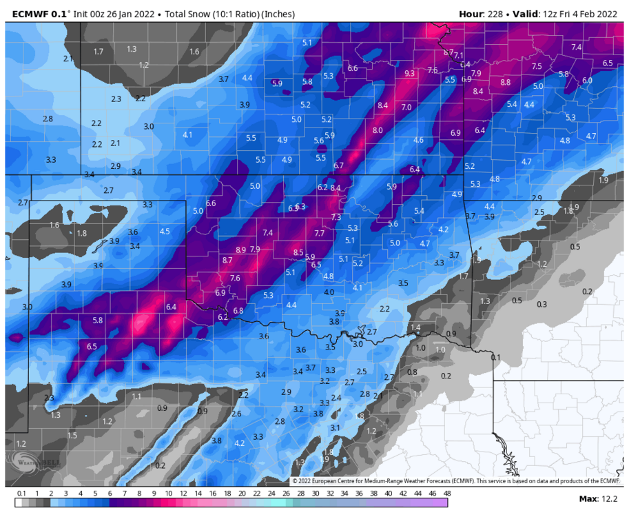
12Z Euro CONTROL run, for those who want to needlessly get their hopes up and enjoy seeing outlandish snow totals. -
MO/KS/AR/OK 2021-2022 Winter Discussion
StormChazer replied to JoMo's topic in Central/Western States
Intense ice storm on the 12Z Canadian. Last night's Euro backed off on the snow but increased ice outputs(frz rain and sleet) for our area. This morning and the noon run of the GFS pushes the storm to the north and leaves all of us relatively high and dry. -
MO/KS/AR/OK 2021-2022 Winter Discussion
StormChazer replied to JoMo's topic in Central/Western States
12Z Euro run... -
MO/KS/AR/OK 2021-2022 Winter Discussion
StormChazer replied to JoMo's topic in Central/Western States


-
MO/KS/AR/OK 2021-2022 Winter Discussion
StormChazer replied to JoMo's topic in Central/Western States
Something may be brewing a week out. Euro gives us a pretty intense winter storm. Freezing rain, sleet and snow. GFS similar, but been bouncing around on location. It’s one to watch. -
MO/KS/AR/OK 2021-2022 Winter Discussion
StormChazer replied to JoMo's topic in Central/Western States
Looking forward, it looks as if there may be something next weekend, but the models are pretty scattered on it. -
MO/KS/AR/OK 2021-2022 Winter Discussion
StormChazer replied to JoMo's topic in Central/Western States
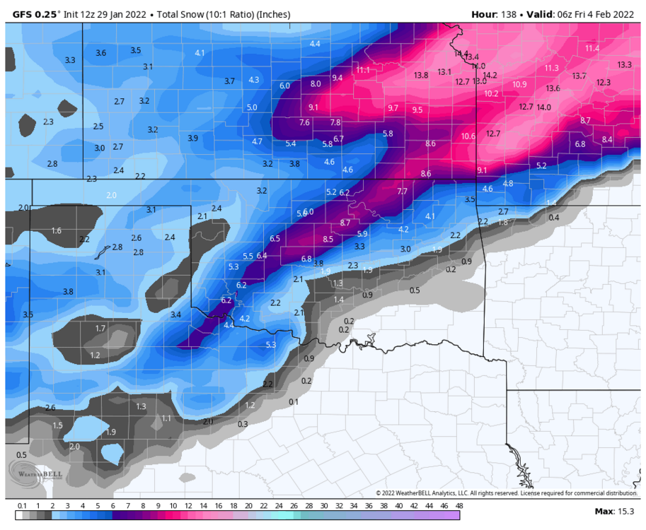
00z NAM showing a faster transition to snow in the initial line that lives through Tulsa. Fingers crossed. -
MO/KS/AR/OK 2021-2022 Winter Discussion
StormChazer replied to JoMo's topic in Central/Western States
18Z NAM over here crushing dreams. -
MO/KS/AR/OK 2021-2022 Winter Discussion
StormChazer replied to JoMo's topic in Central/Western States
That's wild to me, is the elevation really THAT big of a factor down there? -
MO/KS/AR/OK 2021-2022 Winter Discussion
StormChazer replied to JoMo's topic in Central/Western States
12km 3km So around 5 inches for you on this run. -
MO/KS/AR/OK 2021-2022 Winter Discussion
StormChazer replied to JoMo's topic in Central/Western States
For the NAM? I'll send both the 3KM and 12KM, -
MO/KS/AR/OK 2021-2022 Winter Discussion
StormChazer replied to JoMo's topic in Central/Western States
Damn near a foot of snow for him on that run! I live north of Tulsa, so I too, am a fan of that run, gives me about 3 inches in my neck of the woods. I'd take that! This is such a unique setup and storm track with alot of boom/bust potential. I think someone forecasted to get an inch is going to wind up with 6+, and someone slated to get 6 will get 1. It just has that feel to it. I do think it's going to overperform though with some HEAVY snow(thundersnow) for some. -
MO/KS/AR/OK 2021-2022 Winter Discussion
StormChazer replied to JoMo's topic in Central/Western States
Models definitely more favorable for Tulsa today than they were last night. Looks like 1-2 inches in the metro might not be out of the question.