StormChazer
-
Posts
1,231 -
Joined
-
Last visited
Content Type
Profiles
Blogs
Forums
American Weather
Media Demo
Store
Gallery
Everything posted by StormChazer
-

MO/KS/AR/OK 2022-2023 Winter Discussion
StormChazer replied to JoMo's topic in Central/Western States
Recent runs of the HRRR are fixated on having sleet stick around in Tulsa for the first few hours of the event. Can’t say I agree with that. -
MO/KS/AR/OK 2022-2023 Winter Discussion
StormChazer replied to JoMo's topic in Central/Western States
You all are most certainly right, but I'm going to be stubborn and continue posting kuchera amounts because a man can dream, haha. Speaking of, here is the latest NAM, definite uptick in amounts. -
MO/KS/AR/OK 2022-2023 Winter Discussion
StormChazer replied to JoMo's topic in Central/Western States
I feel as if a picture is beginning to be painted. All 3 of the global models(including the morning run of the Euro) have inched their way back into the Tulsa metro area and upped amounts in AR. Also the 12Z run of the HRRR supports this (fwiw). Only the NAM is being a downer on this. -
MO/KS/AR/OK 2022-2023 Winter Discussion
StormChazer replied to JoMo's topic in Central/Western States
This is such a fine line between the have and have nots. Someone here is going to get a technical white christmas(1 inch on the ground at 7AM Christmas Day). At this point, it comes down to when the storm actually forms and starts moving through, then we will know who gets lucky with a moderate band of snow and who doesn't, that will make all the difference as I think this will be a hit or miss kind of situation. Also, gotta watch out for some brief sleet and freezing rain as the front is moving through, might make roads slick. -
MO/KS/AR/OK 2022-2023 Winter Discussion
StormChazer replied to JoMo's topic in Central/Western States
Still think I can squeeze 2 inches out here in north Tulsa county. -
MO/KS/AR/OK 2022-2023 Winter Discussion
StormChazer replied to JoMo's topic in Central/Western States
00Z Euro. Definitely trended back to be a little more favorable for all of us. Looks like I might get that 30 mile shift I was hoping for earlier today.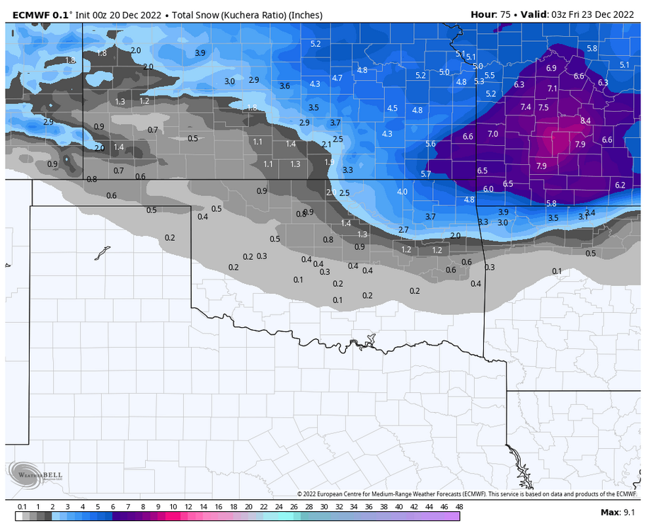
-
MO/KS/AR/OK 2022-2023 Winter Discussion
StormChazer replied to JoMo's topic in Central/Western States
Evening euro trending in our favor.
-
MO/KS/AR/OK 2022-2023 Winter Discussion
StormChazer replied to JoMo's topic in Central/Western States
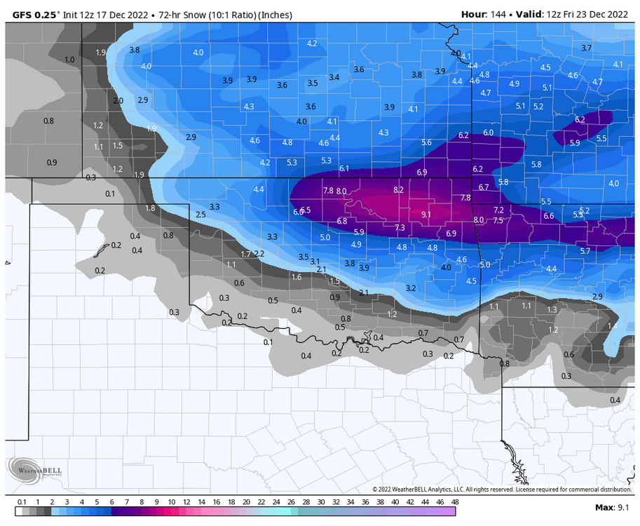
The latest GFS brings us a little more hope. As does the Hi res Canadian. -
MO/KS/AR/OK 2022-2023 Winter Discussion
StormChazer replied to JoMo's topic in Central/Western States
Normally I don't since people tend to use Kuchera as hopium or for shock value, but I feel like these temps truly warrant it. I feel like it would be more accurate than using a base 10:1, even if it's still blown out of proportion a bit. Speaking of, here is the latest NAM. -
MO/KS/AR/OK 2022-2023 Winter Discussion
StormChazer replied to JoMo's topic in Central/Western States
I'm not asking for 10 inches here in North Tulsa, I'd be happy with 3-4(heck 2 at the rate it's going). Just need a 30 mile shift south. I don't feel like that's egregious to ask for at this stage of the game, still possible... -
MO/KS/AR/OK 2022-2023 Winter Discussion
StormChazer replied to JoMo's topic in Central/Western States
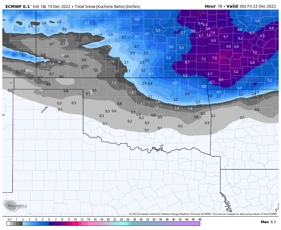
Slight southern shift on the 06Z Euro run FWIW. -
MO/KS/AR/OK 2022-2023 Winter Discussion
StormChazer replied to JoMo's topic in Central/Western States
What’s odd is to my unprofessional eye, the gfs diggs south and west a touch more and yet the precip shifted considerably north. Want to see the ensembles and see if this winds up being an outlier. -
MO/KS/AR/OK 2022-2023 Winter Discussion
StormChazer replied to JoMo's topic in Central/Western States
I can tell you the short range 18Z Canadian is more west on the last hour than the long range 12Z is at that same time. Also the icon is jogging west as well on the 18Z run. -
MO/KS/AR/OK 2022-2023 Winter Discussion
StormChazer replied to JoMo's topic in Central/Western States
Pretty much. But its still exciting to see haha. -
MO/KS/AR/OK 2022-2023 Winter Discussion
StormChazer replied to JoMo's topic in Central/Western States
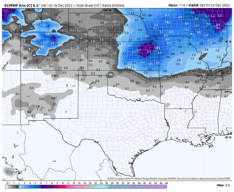
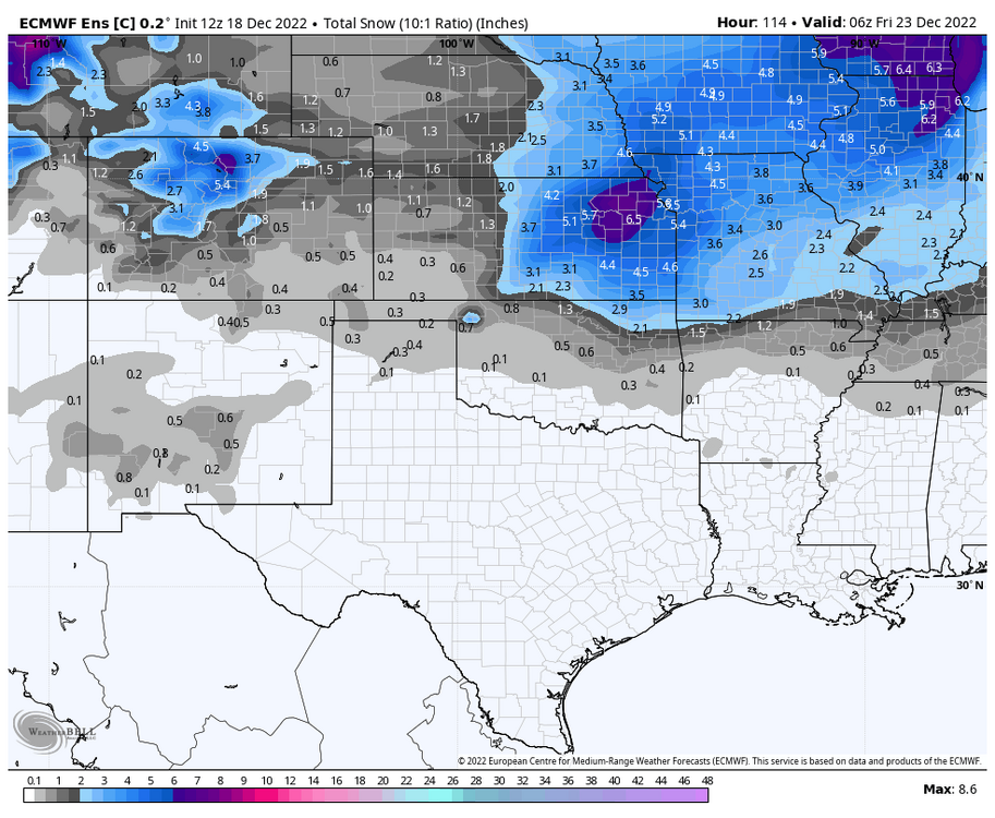
Here is the euro ensemble mean. Last night vs this afternoon. So on average more snow and further south a smidge.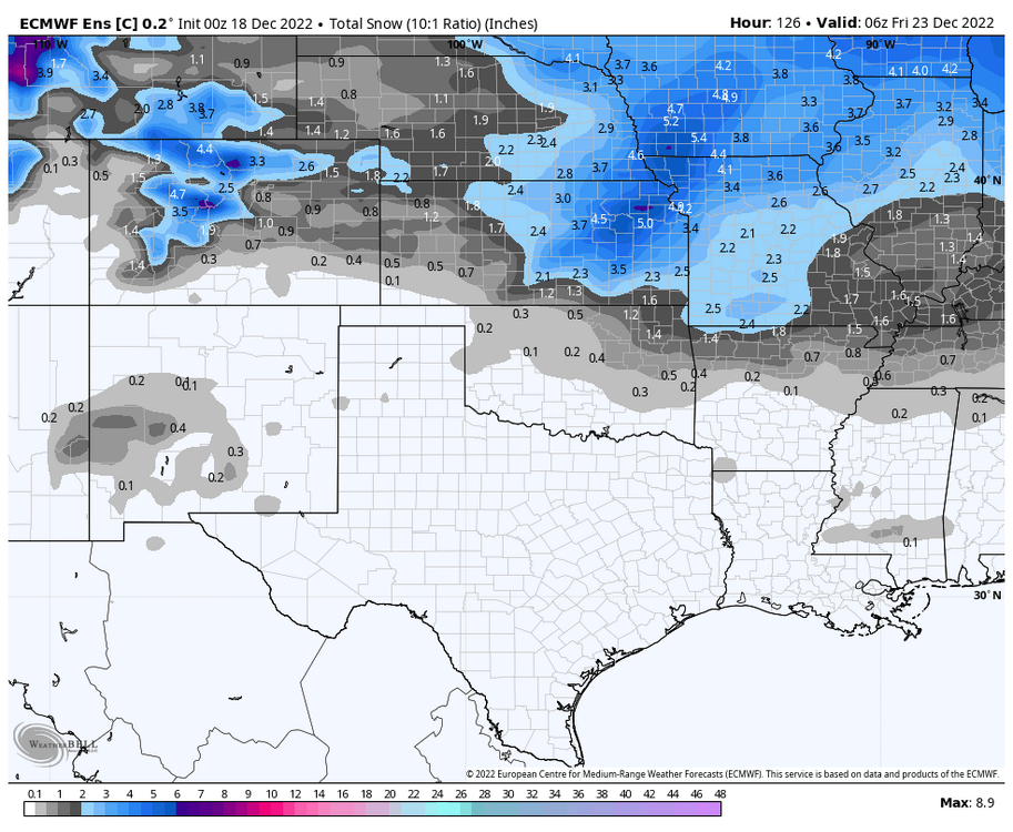
-
MO/KS/AR/OK 2022-2023 Winter Discussion
StormChazer replied to JoMo's topic in Central/Western States
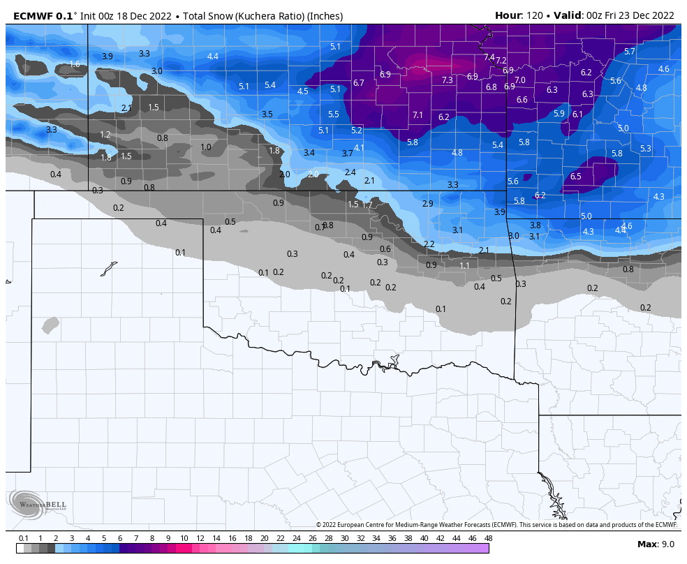
Put this in the win column. The 12Z Euro continues the slight nudges toward the GFS. 00Z Euro run 12Z Euro run. Higher amounts(yes I’m using kuchera) and slightly more SW.
-
MO/KS/AR/OK 2022-2023 Winter Discussion
StormChazer replied to JoMo's topic in Central/Western States
GFS members.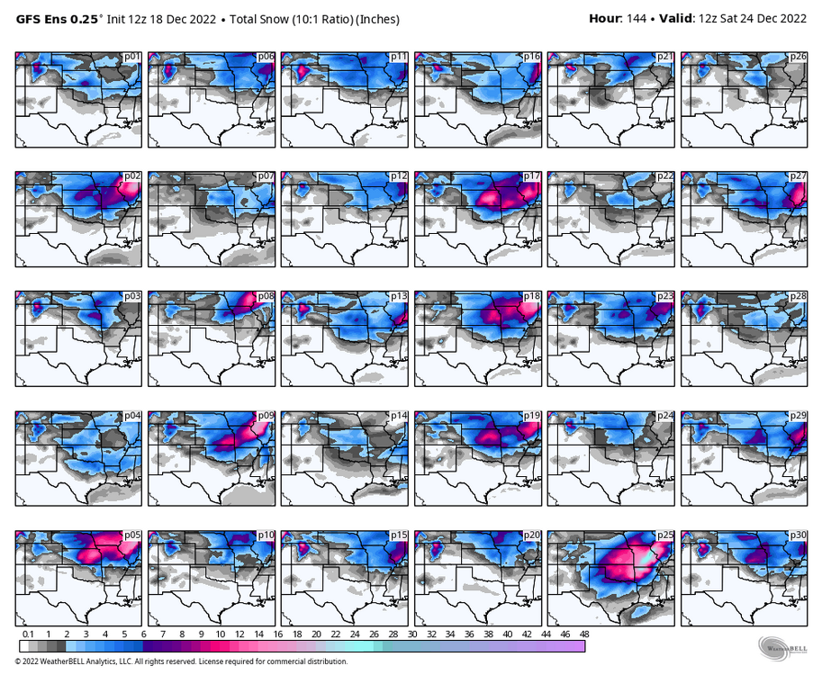
-
MO/KS/AR/OK 2022-2023 Winter Discussion
StormChazer replied to JoMo's topic in Central/Western States
A definite shift in the right direction. Last night Today.

-
MO/KS/AR/OK 2022-2023 Winter Discussion
StormChazer replied to JoMo's topic in Central/Western States
Based off the upper air vorticity so far, looking like the Canadian is going to fall more in like with the GFS after last night’s abysmal run. We’ll see, I could be wrong. -
MO/KS/AR/OK 2022-2023 Winter Discussion
StormChazer replied to JoMo's topic in Central/Western States
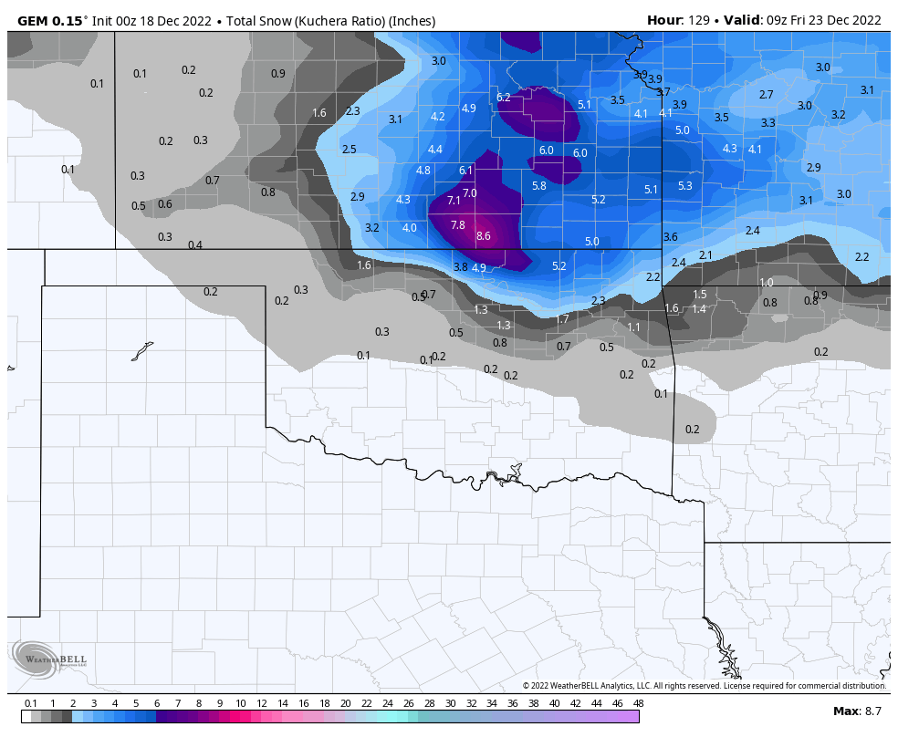
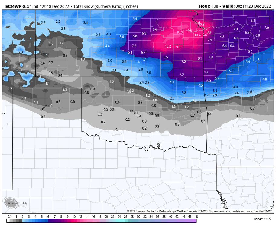
Posting the kuchera amounts for maximum weenie hype. Big takeaway is that after yesterday night’s shift to the SW, it’s looking like it was an outlier run.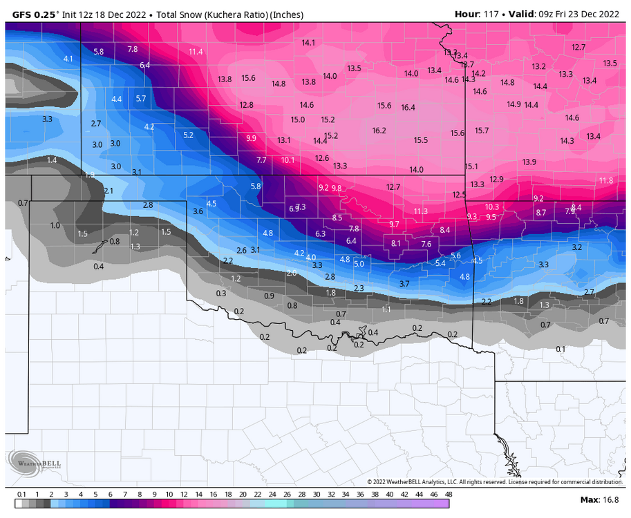
-
MO/KS/AR/OK 2022-2023 Winter Discussion
StormChazer replied to JoMo's topic in Central/Western States
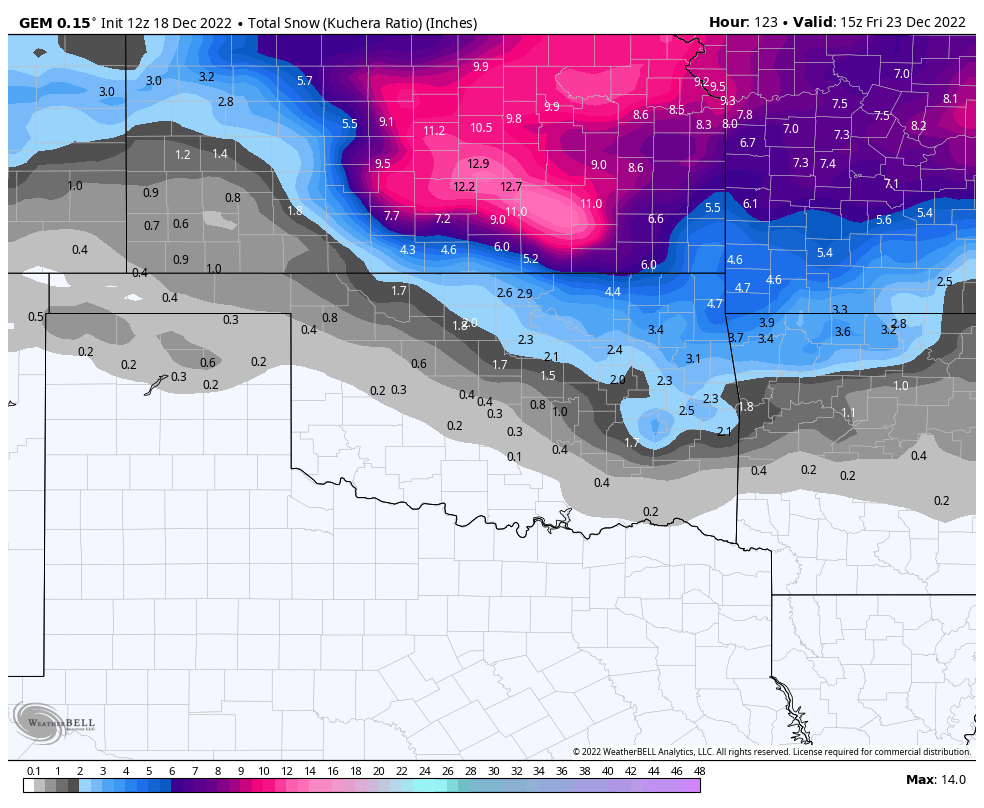
It’ll be interesting to watch. After last night’s run of the GFS going even further south and west, this morning’s has jogged NE. Have to wonder if it continues going NE more toward a Euro or Canadian solution, or if it stays out and the others move it’s way. The icon, which was one of the first to sniff out this change, has been trending back to the NE and leaving us high and dry. So I think today’s runs are going ti be very telling. -
MO/KS/AR/OK 2022-2023 Winter Discussion
StormChazer replied to JoMo's topic in Central/Western States
Euro starting to trend snowier. Less about the amounts and more about location. 12Z and 00Z for comparison. -
MO/KS/AR/OK 2022-2023 Winter Discussion
StormChazer replied to JoMo's topic in Central/Western States
Until the Euro hops on, I remain uneasy. -
MO/KS/AR/OK 2022-2023 Winter Discussion
StormChazer replied to JoMo's topic in Central/Western States
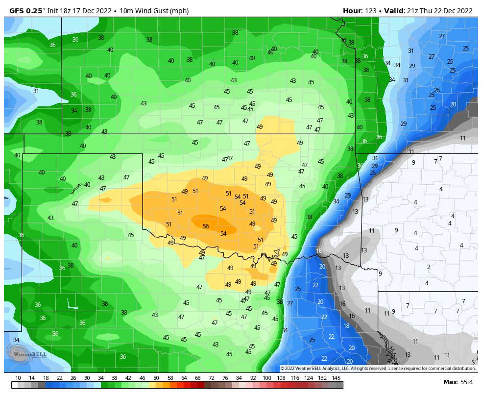
Another strong showing from the 18Z GFS. Blizzard criteria. Don’t get me started on the kuchera amounts haha.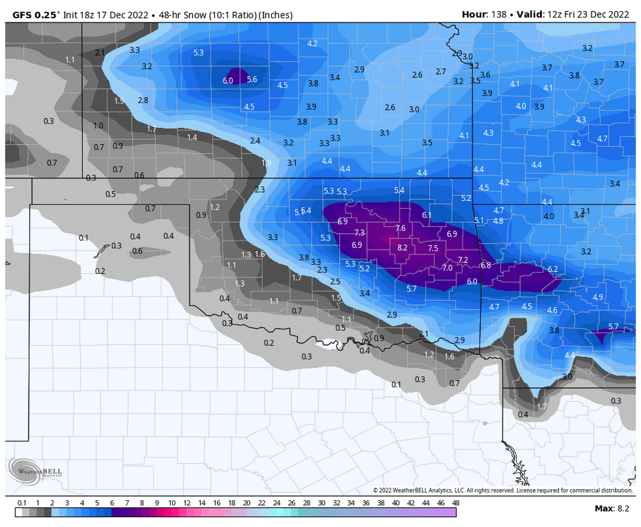

-
MO/KS/AR/OK 2022-2023 Winter Discussion
StormChazer replied to JoMo's topic in Central/Western States
Another dream run from the GFS after looking disorganized last night. This is just this storm totals isolated.