StormChazer
-
Posts
1,231 -
Joined
-
Last visited
Content Type
Profiles
Blogs
Forums
American Weather
Media Demo
Store
Gallery
Everything posted by StormChazer
-

MO/KS/AR/OK 2021-2022 Winter Discussion
StormChazer replied to JoMo's topic in Central/Western States
TSA mentioning potential lake effect snow in north to south oriented lakes here in OK. Specifically mentions Lake Oologah, which I can confirm produced lake effect snow at my house last year during the intense cold snap. I'm just summarizing here, but they essentially said, that at a minimum, NE OK and NW AR should see 4 inches of snow, but could see 7-10 inches in a "reasonable worst case scenario". -
MO/KS/AR/OK 2021-2022 Winter Discussion
StormChazer replied to JoMo's topic in Central/Western States
In addition to the NAM, here was the 12Z of the HRRR, and still snowing. -
MO/KS/AR/OK 2021-2022 Winter Discussion
StormChazer replied to JoMo's topic in Central/Western States
NAM is looking interesting so far. Not sure what to make of it yet. -
MO/KS/AR/OK 2021-2022 Winter Discussion
StormChazer replied to JoMo's topic in Central/Western States
18Z NAM results. And still snowing... -
MO/KS/AR/OK 2021-2022 Winter Discussion
StormChazer replied to JoMo's topic in Central/Western States
TSA expanded the winter storm watch to it's entire area. -
MO/KS/AR/OK 2021-2022 Winter Discussion
StormChazer replied to JoMo's topic in Central/Western States
Latest GFS. On top of the warm nose receding to the SE, it really dumps some good snow on the back end of the storm Thursday night. -
MO/KS/AR/OK 2021-2022 Winter Discussion
StormChazer replied to JoMo's topic in Central/Western States

-
MO/KS/AR/OK 2021-2022 Winter Discussion
StormChazer replied to JoMo's topic in Central/Western States
TSA.. WINTER STORM WATCH IN EFFECT FROM LATE TUESDAY NIGHT THROUGH THURSDAY EVENING... * WHAT...Heavy mixed precipitation possible. Precipitation starts off as freezing rain, then transitions to sleet and eventually snow as the event progresses. Ice accumulations of one tenth to one half of an inch possible. Total snow and sleet accumulations of 1 to 10 inches possible. * WHERE...Portions of east central, northeast and southeast Oklahoma and northwest Arkansas. * WHEN...From late Tuesday night through Thursday evening. * IMPACTS...Power outages and tree damage are possible due to the ice. Travel could be nearly impossible. The hazardous driving conditions will disrupt daily life later this week. * ADDITIONAL DETAILS...Emergency managers and first responders should continue to prepare for a winter storm later this week. A disruption to daily life is likely, with threats to life and property possible. -
MO/KS/AR/OK 2021-2022 Winter Discussion
StormChazer replied to JoMo's topic in Central/Western States
06Z NAM vs the 12Z NAM. BIG SE jump with the snow(and still snowing) -
MO/KS/AR/OK 2021-2022 Winter Discussion
StormChazer replied to JoMo's topic in Central/Western States
NAM with a SE nudge on the warm nose. -
MO/KS/AR/OK 2021-2022 Winter Discussion
StormChazer replied to JoMo's topic in Central/Western States
GFS nudged SE, 06Z Euro eeevveeeer so slightly nudged SE as well. NAM still doing it’s North trend. -
MO/KS/AR/OK 2021-2022 Winter Discussion
StormChazer replied to JoMo's topic in Central/Western States
Not the most profound image but this is from TSA.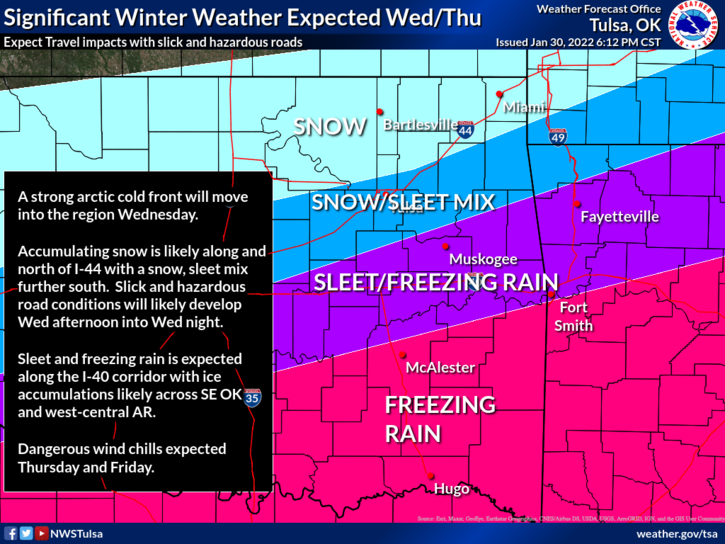
-
MO/KS/AR/OK 2021-2022 Winter Discussion
StormChazer replied to JoMo's topic in Central/Western States
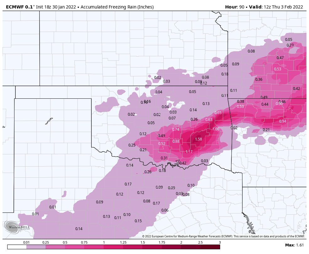
Oh, almost forgot the ice totals.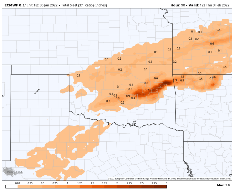
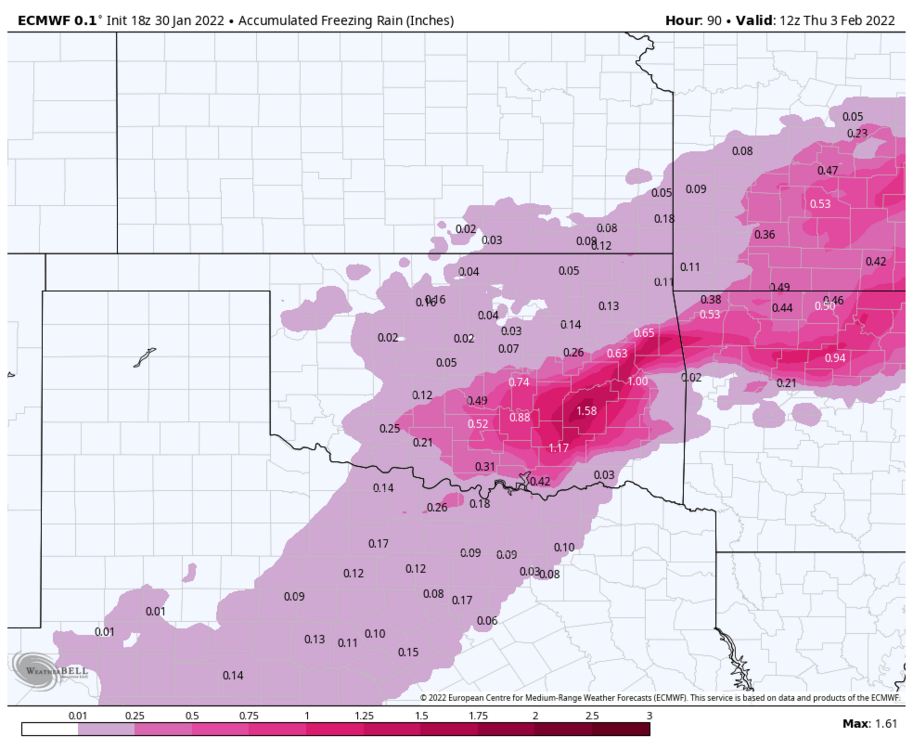
-
MO/KS/AR/OK 2021-2022 Winter Discussion
StormChazer replied to JoMo's topic in Central/Western States
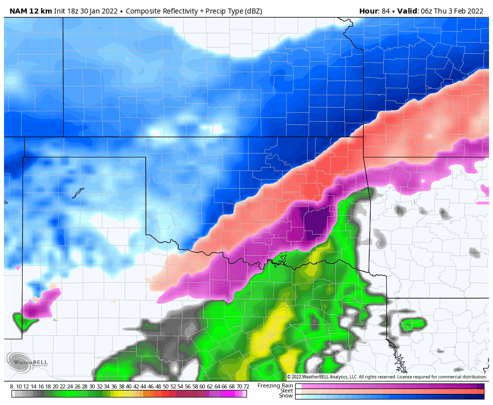
This is at 6:00AM Thursday and still snowing.
-
MO/KS/AR/OK 2021-2022 Winter Discussion
StormChazer replied to JoMo's topic in Central/Western States
Hr 84 of the RDPS So expect the 00Z Canadian to look more like the 12Z Euro than the 18Z GFS. But like Mo said above, don't get so fixated on the run to run model outputs. Save that for once we are within 48 hours of the main event, that's when we will start to see the real picture in the atmosphere, to determined precip types. And if I'm being totally honest, when it comes to a mixed bag like this, sometimes, it comes down to real time reports before you truly know what your dominant precip type is going to be. Don't forget, with a storm like this, if you change over to snow an hour or 2 earlier than the models predict, BOOM, you get a dumping. -
MO/KS/AR/OK 2021-2022 Winter Discussion
StormChazer replied to JoMo's topic in Central/Western States
The last hour of the NAM.
-
MO/KS/AR/OK 2021-2022 Winter Discussion
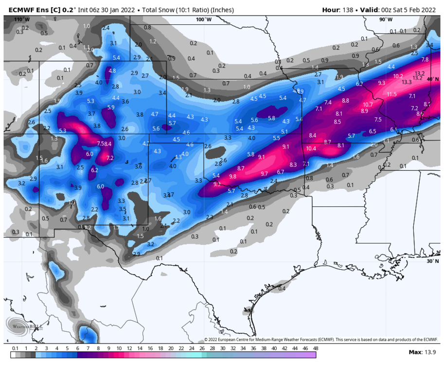
StormChazer replied to JoMo's topic in Central/Western States
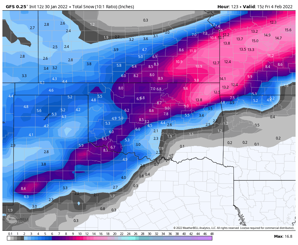
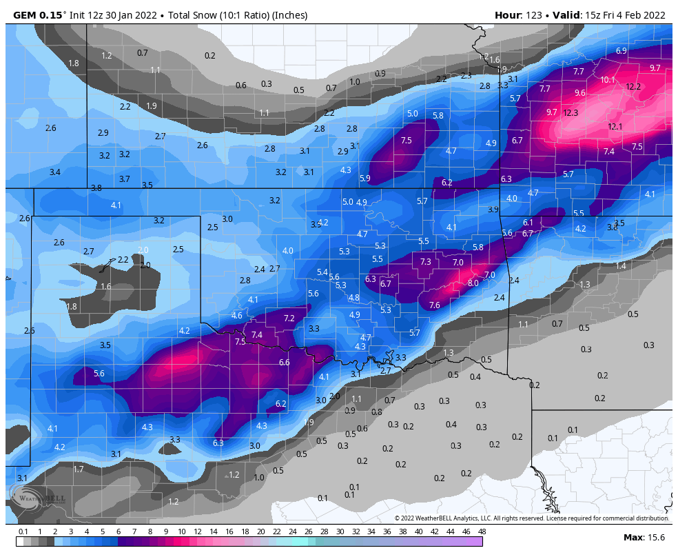
Only major disagreement I see in the models, at this point, is the debate of an ice storm for DFW. Here are the 10:1 snow ratios for the 3 major models. Other than the Canadian(which the run before looked similar to these), which is toned down some this run, they look strikingly similar. Euro GFS Canadian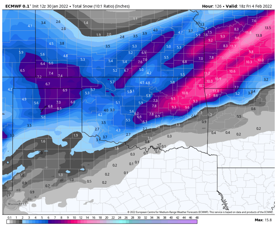

-
MO/KS/AR/OK 2021-2022 Winter Discussion
StormChazer replied to JoMo's topic in Central/Western States
A definite shift north on the 12Z Euro. The 6Z was right on the trend. -
MO/KS/AR/OK 2021-2022 Winter Discussion
StormChazer replied to JoMo's topic in Central/Western States
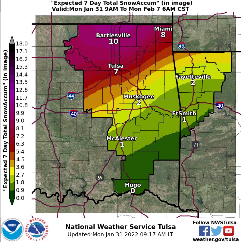
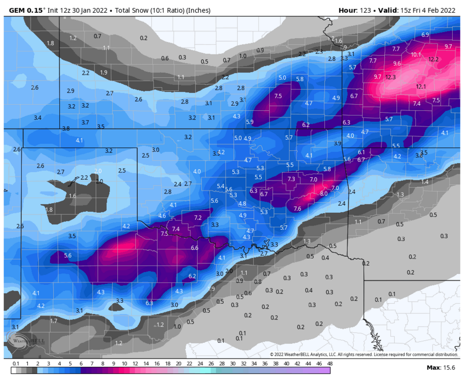
Tulsa NWS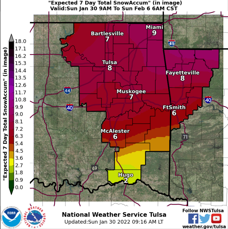
-
MO/KS/AR/OK 2021-2022 Winter Discussion
StormChazer replied to JoMo's topic in Central/Western States
This is as far out at the 6Z goes, but you can clearly see where the intense band of snow is setting up. I can run the 06Z Euro CONTROL run out further, which shows you where that heavy snow sets up. Again, you can’t trust the 06Z and 18Z runs of the euro as much as their 12Z and 0Z counterparts, as they use outdated upper air data, but they can still sniff out a trend sometimes.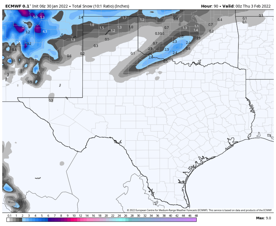
-
MO/KS/AR/OK 2021-2022 Winter Discussion
StormChazer replied to JoMo's topic in Central/Western States
I didn’t love the 00Z run of the euro last night. However, the 06Z euro shows a notable shift back to the north again. So we’ll see if the 12Z follows suit. -
MO/KS/AR/OK 2021-2022 Winter Discussion
StormChazer replied to JoMo's topic in Central/Western States
I was gonna say to each his own. Sleet can be pretty fun when you get a couple inches of it. Freezing rain however, not so much. -
MO/KS/AR/OK 2021-2022 Winter Discussion
StormChazer replied to JoMo's topic in Central/Western States
This has been some impressive model agreement across the board…and for a while now. -
MO/KS/AR/OK 2021-2022 Winter Discussion
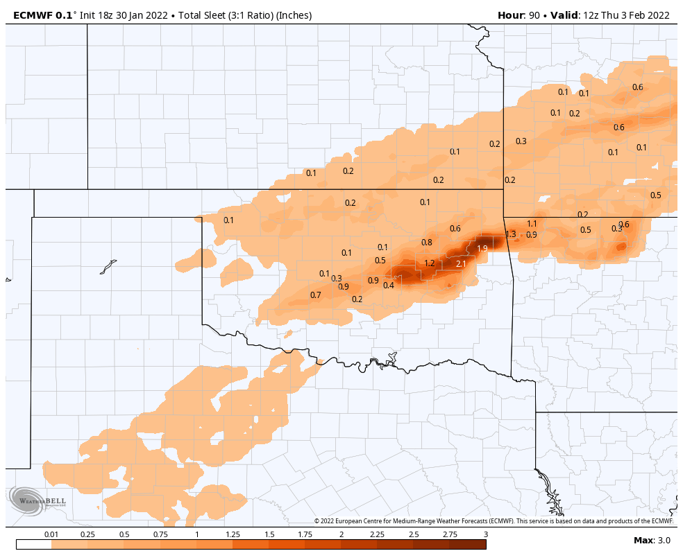
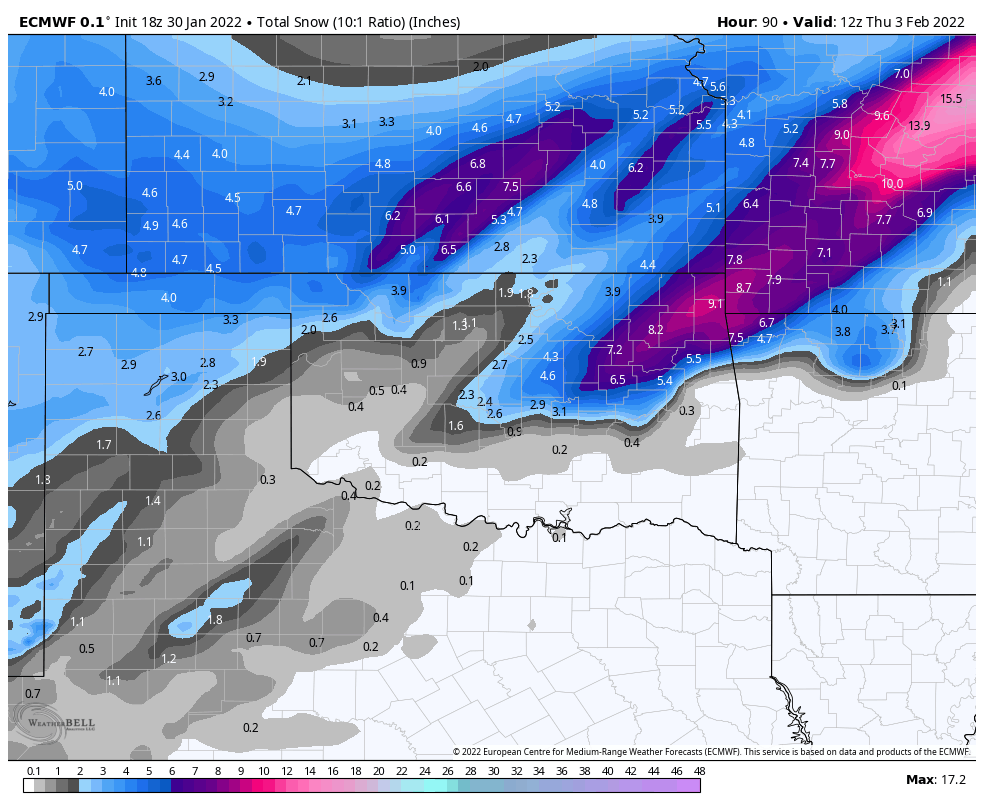
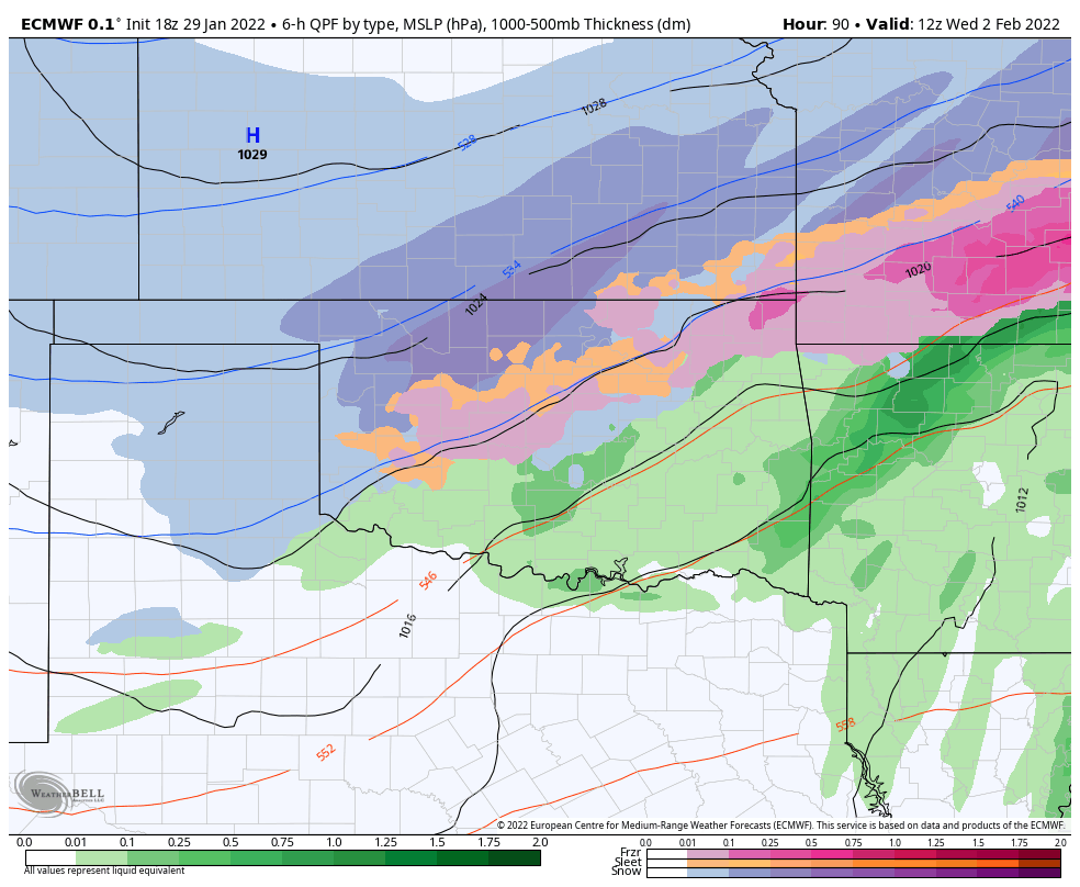
StormChazer replied to JoMo's topic in Central/Western States
Hour 90 of the 18Z Euro for what it’s worth.
-
MO/KS/AR/OK 2021-2022 Winter Discussion
StormChazer replied to JoMo's topic in Central/Western States
Here is the 18Z GFS.