StormChazer
-
Posts
1,231 -
Joined
-
Last visited
Content Type
Profiles
Blogs
Forums
American Weather
Media Demo
Store
Gallery
Everything posted by StormChazer
-

MO/KS/AR/OK 2020-2021 "Winter" Discussion
StormChazer replied to JoMo's topic in Central/Western States
Yeah, it's almost noon and we've got light snow still forming to the west of Tulsa. Definitely not something most of the models picked up on at all... -
MO/KS/AR/OK 2020-2021 "Winter" Discussion
StormChazer replied to JoMo's topic in Central/Western States
Keep it coming! -
MO/KS/AR/OK 2020-2021 "Winter" Discussion
StormChazer replied to JoMo's topic in Central/Western States
TSA touches on this, says there's a chance we really bottom out. The snow is finally winding down across northeast Oklahoma and northwest Arkansas as the system continues to push off to the east and northeast. The latest mesoanalysis and radar imagery continues to suggest a little bit of enhanced frontogenetical banding continuing over northeast Oklahoma and northwest Arkansas. Locally moderate to heavy snowfall continues to be reported at this time. An additional inch of snow will be possible this morning through early this afternoon across far eastern Oklahoma and northwestern Arkansas. Behind this wave of snow, the clouds are breaking with mostly clear skies across much of central and southern Oklahoma with clearing skies moving into eastern Oklahoma. This clearing is expected to be short lived before clouds move in later this afternoon and evening. There is still some uncertainty in terms of cloud cover for this evening and overnight. If clouds scatter out or clear, temperatures will hit rock bottom tonight especially since winds will be light. AKA tonight will potentially be a perfect situation for intense radiational cooling with temperatures possibly lower than currently forecast. Confidence, however is not high enough at this time to adjust temperatures overnight from the previous forecast. Trends will continue to be monitored. The next wave of snow moves in by late morning or early afternoon tomorrow. -
MO/KS/AR/OK 2020-2021 "Winter" Discussion
StormChazer replied to JoMo's topic in Central/Western States
TSA on the next storm.(includes .2 in for Today's snow in Tulsa, and .9 in NW AR, so subtract that.) -
MO/KS/AR/OK 2020-2021 "Winter" Discussion
StormChazer replied to JoMo's topic in Central/Western States
What he said ^^^ It's funny because I see blue sky and these are some of the bigger flakes I've seen haha.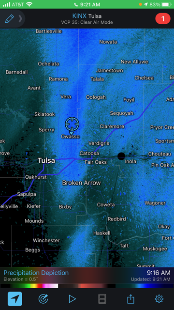
-
MO/KS/AR/OK 2020-2021 "Winter" Discussion
StormChazer replied to JoMo's topic in Central/Western States
3K Nam -
MO/KS/AR/OK 2020-2021 "Winter" Discussion
StormChazer replied to JoMo's topic in Central/Western States
Didn’t think I’d wake to it still snowing in Tulsa, I won’t complain. -
MO/KS/AR/OK 2020-2021 "Winter" Discussion
StormChazer replied to JoMo's topic in Central/Western States
As of 10:00 PM -
MO/KS/AR/OK 2020-2021 "Winter" Discussion
StormChazer replied to JoMo's topic in Central/Western States
Owasso checking in. I honestly couldn’t tell you how much we’ve gotten so far, it’s just blowing around and I don’t have a good spot to measure(my back yard is to a pond and there’s drifts everywhere). But it’s been coming down nicely since about 4:45. Radar looks like it’s filling in near OKC, which bodes well for us up here in Tulsa. So far, I’m happy with this. Dry powdery snow is a new thing for me, so it’s odd that I can still see grass poking through, but then there’s a 1 and a half foot drift on the side of my house lol. -
MO/KS/AR/OK 2020-2021 "Winter" Discussion
StormChazer replied to JoMo's topic in Central/Western States
I know this break in snow is to be expected. But seeing OKC getting hammered with me sitting and waiting is making me anxious XD -
MO/KS/AR/OK 2020-2021 "Winter" Discussion
StormChazer replied to JoMo's topic in Central/Western States
06Z EURO has it wrapping up like the NAM. This is 3PM MONDAY. -
MO/KS/AR/OK 2020-2021 "Winter" Discussion
StormChazer replied to JoMo's topic in Central/Western States
Enjoying myself in N Tulsa right now. Couldn’t tell you how much we’ve gotten, it’s just blowing around all over the place haha. -
MO/KS/AR/OK 2020-2021 "Winter" Discussion
StormChazer replied to JoMo's topic in Central/Western States
I approve. -
MO/KS/AR/OK 2020-2021 "Winter" Discussion
StormChazer replied to JoMo's topic in Central/Western States
-
MO/KS/AR/OK 2020-2021 "Winter" Discussion
StormChazer replied to JoMo's topic in Central/Western States
It's an awesome phenomenon for a part of the country that frequently gets above 100 degrees in the summer. -
MO/KS/AR/OK 2020-2021 "Winter" Discussion
StormChazer replied to JoMo's topic in Central/Western States
I'll be sure to update. Will probably post pictures too. Maybe even a video. -
MO/KS/AR/OK 2020-2021 "Winter" Discussion
StormChazer replied to JoMo's topic in Central/Western States
Is that what that is? Wow, didn't think it was capable of that, but makes sense. We were the beneficiary of some of that lake effect snow, so if the winds are favorable, we might get a boost from that too here. -
MO/KS/AR/OK 2020-2021 "Winter" Discussion
StormChazer replied to JoMo's topic in Central/Western States
North Tulsa county in Owasso/Collinsville. -
MO/KS/AR/OK 2020-2021 "Winter" Discussion
StormChazer replied to JoMo's topic in Central/Western States
0z 3K NAM looking Nice!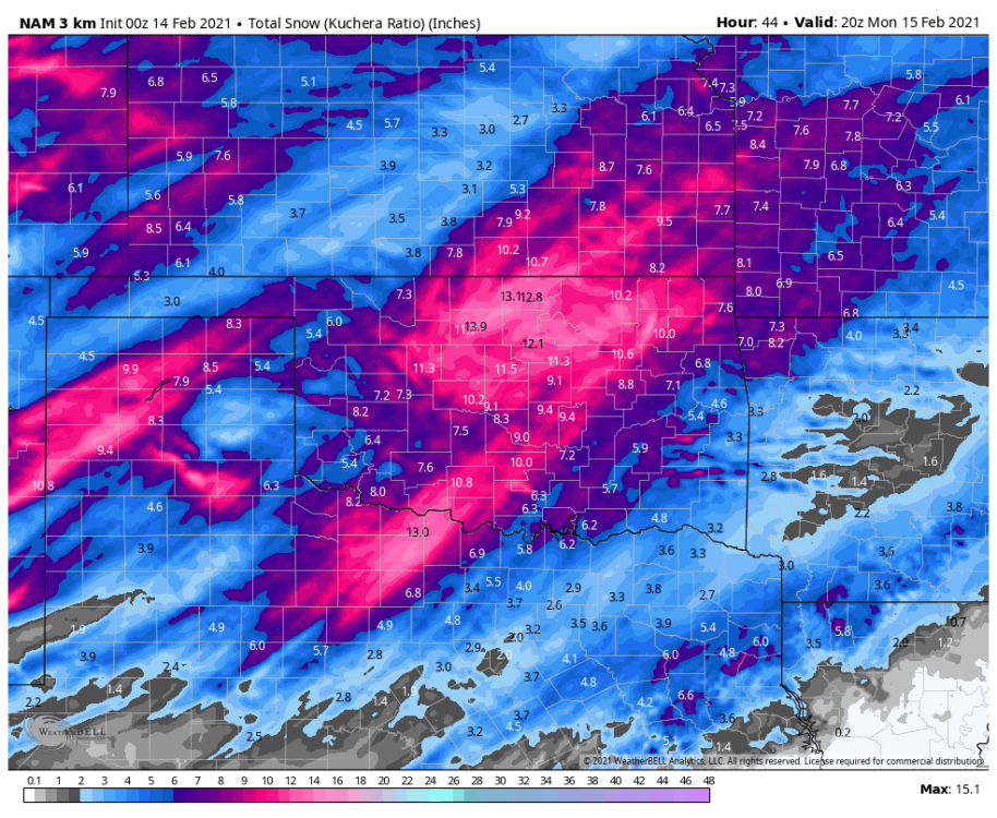
-
MO/KS/AR/OK 2020-2021 "Winter" Discussion
StormChazer replied to JoMo's topic in Central/Western States
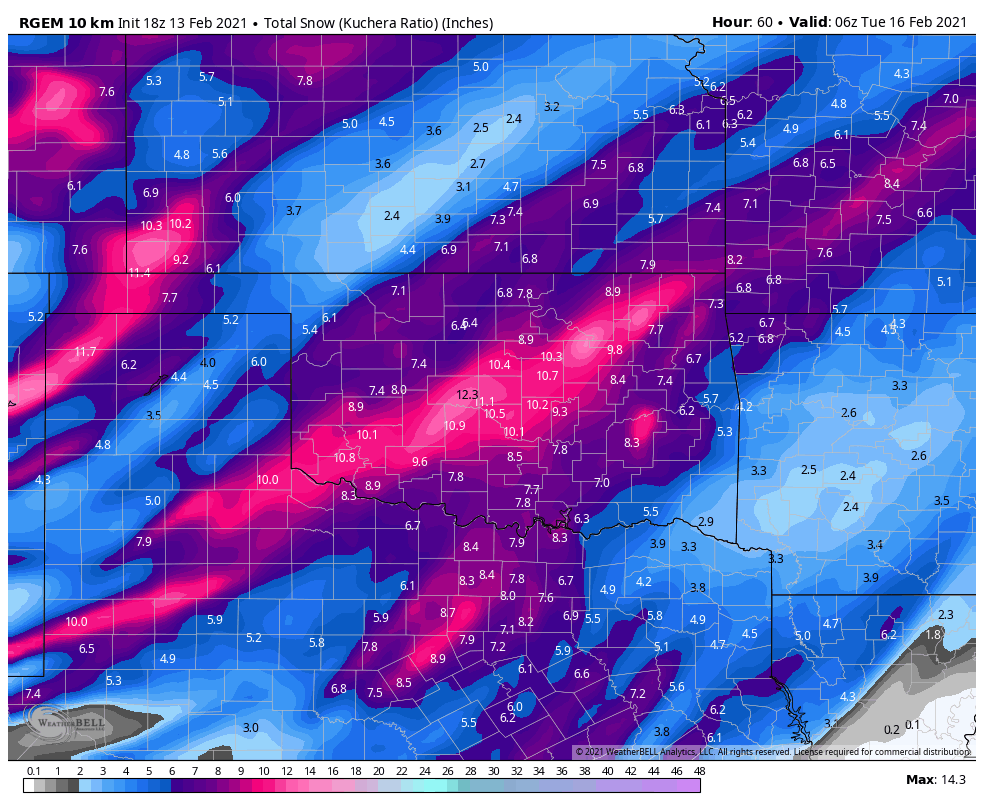
With storm #2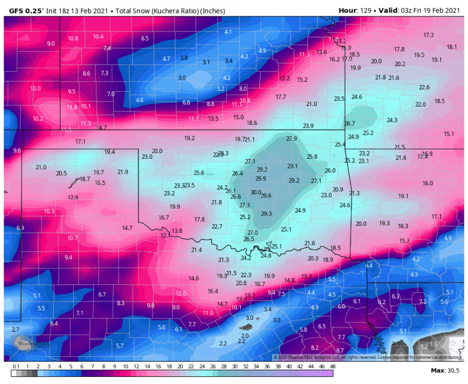
-
MO/KS/AR/OK 2020-2021 "Winter" Discussion
StormChazer replied to JoMo's topic in Central/Western States
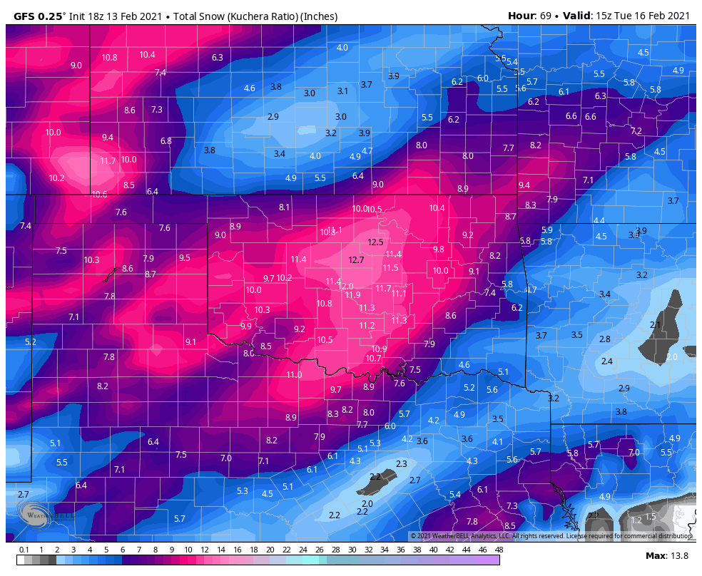
Storm 1 18Z GFS
-
MO/KS/AR/OK 2020-2021 "Winter" Discussion
StormChazer replied to JoMo's topic in Central/Western States

-
MO/KS/AR/OK 2020-2021 "Winter" Discussion
StormChazer replied to JoMo's topic in Central/Western States
High res Canadian is catching onto that heavy band near I-44.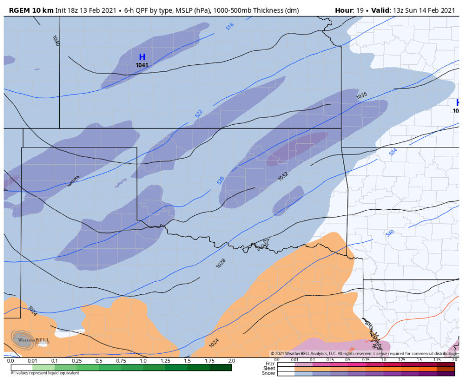
-
MO/KS/AR/OK 2020-2021 "Winter" Discussion
StormChazer replied to JoMo's topic in Central/Western States
Sorry! Late to the party, running errands!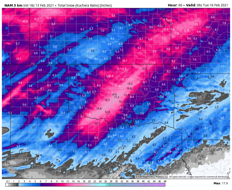
-
MO/KS/AR/OK 2020-2021 "Winter" Discussion
StormChazer replied to JoMo's topic in Central/Western States
The Euro trended a touch slower and westward for the 2nd storm. So towards the insane GFS, but still has a ways to go.