StormChazer
-
Posts
1,231 -
Joined
-
Last visited
Content Type
Profiles
Blogs
Forums
American Weather
Media Demo
Store
Gallery
Everything posted by StormChazer
-

MO/KS/AR/OK 2020-2021 "Winter" Discussion
StormChazer replied to JoMo's topic in Central/Western States
Euro letting me go to bed happy tonight. Still looking good. -
MO/KS/AR/OK 2020-2021 "Winter" Discussion
StormChazer replied to JoMo's topic in Central/Western States
12Z RDPS btw. Falling in line with the area of snow, just low on totals for many. But a big step in the right direction for the Canadian. -
MO/KS/AR/OK 2020-2021 "Winter" Discussion
StormChazer replied to JoMo's topic in Central/Western States
1st storm, GFS -
MO/KS/AR/OK 2020-2021 "Winter" Discussion
StormChazer replied to JoMo's topic in Central/Western States
-
MO/KS/AR/OK 2020-2021 "Winter" Discussion
StormChazer replied to JoMo's topic in Central/Western States
Interesting because it gives western OK(currently projected to get the most) the very least. The system moves in early Sunday before Sunset and exits quickly. Hence the lighter totals for some.
-
MO/KS/AR/OK 2020-2021 "Winter" Discussion
StormChazer replied to JoMo's topic in Central/Western States
9.5 inch for the Sun/Mon storm. Not bad! -
MO/KS/AR/OK 2020-2021 "Winter" Discussion
StormChazer replied to JoMo's topic in Central/Western States
-
MO/KS/AR/OK 2020-2021 "Winter" Discussion
StormChazer replied to JoMo's topic in Central/Western States
We are living in a simulation. -
MO/KS/AR/OK 2020-2021 "Winter" Discussion
StormChazer replied to JoMo's topic in Central/Western States
First storm. 18ZGFS -
MO/KS/AR/OK 2020-2021 "Winter" Discussion
StormChazer replied to JoMo's topic in Central/Western States
Winter Storm watches blossoming up from North Texas and points north. -
MO/KS/AR/OK 2020-2021 "Winter" Discussion
StormChazer replied to JoMo's topic in Central/Western States
TSA Discussion. Now to the meat of the forecast. Model data continues to be very consistent for days (scary) in bringing the next upper storm system into the Plains Sunday and Monday. Looks like a very favorable setup synoptically (coupled jets, upper diffluent flow) for a major winter storm, with the feel of February 2011. We have a deepening arctic air mass in place, and favorable dynamics to draw in moisture and produce lift over this cold air. Snow ratios will be increasing with time, potentially rising to 20:1 or higher across the north, while QPF will be higher in the south. So it appears that all of eastern Oklahoma and northwest Arkansas will be under the gun. The snow, which could be heavy at times, will combine with gusty north winds to produce a lot of blowing and drifting of snow and dangerous travel conditions. That said, we are still several days out and details can change so it`s still too early to get specific with amounts and locations. A Special Weather Statement has been issued with a Winter Storm Watch likely coming tonight or tomorrow. If that wasn`t enough another system will follow it on its heels and will spread more snow over our area late Tuesday into Wednesday. The winds will not be as strong with this system. It is a one-two punch of sorts. In the wake of this system, a pattern change is expected, with the blocking pattern finally breaking down and evolving into a low- amplitude progressive regime. We will warm up eventually, once operation snowmelt is completed. -
MO/KS/AR/OK 2020-2021 "Winter" Discussion
StormChazer replied to JoMo's topic in Central/Western States
NAM ramping up at hour 63. -
MO/KS/AR/OK 2020-2021 "Winter" Discussion
StormChazer replied to JoMo's topic in Central/Western States
Now I've seen it all. Tulsa-Rogers-Creek- Including the cities of Tulsa, Claremore, and Sapulpa 215 PM CST Thu Feb 11 2021 ...WINTER WEATHER ADVISORY IN EFFECT UNTIL 6 AM CST FRIDAY... ...WIND CHILL ADVISORY IN EFFECT FROM 3 AM TO NOON CST FRIDAY... * WHAT...Lake effect snow. Additional snow accumulations of up to one inch. Very cold wind chills expected late tonight into Friday morning. Wind chills as low as 10 below zero. * WHERE...Tulsa, Rogers and Creek Counties. * WHEN...For the Winter Weather Advisory, until 6 AM CST Friday. For the Wind Chill Advisory, from 3 AM to noon CST Friday. * IMPACTS...Plan on slippery road conditions along the lake effect snow band. The hazardous conditions could impact the evening commute. Frost bite and hypothermia are possible if precautions are not taken late tonight into Friday morning. PRECAUTIONARY/PREPAREDNESS ACTIONS... Slow down and use caution while traveling. Use caution while traveling outside. Wear appropriate clothing, a hat, and gloves. -
MO/KS/AR/OK 2020-2021 "Winter" Discussion
StormChazer replied to JoMo's topic in Central/Western States
NWS in Tulsa issued a winter weather advisory for like 3 counties here in Tulsa metro. -
MO/KS/AR/OK 2020-2021 "Winter" Discussion
StormChazer replied to JoMo's topic in Central/Western States
You beat me to it! -
MO/KS/AR/OK 2020-2021 "Winter" Discussion
StormChazer replied to JoMo's topic in Central/Western States
-
MO/KS/AR/OK 2020-2021 "Winter" Discussion
StormChazer replied to JoMo's topic in Central/Western States
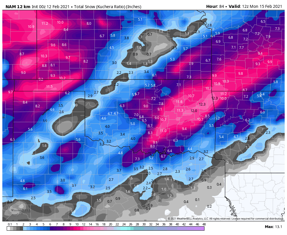
Here is the totals from both storms. -
MO/KS/AR/OK 2020-2021 "Winter" Discussion
StormChazer replied to JoMo's topic in Central/Western States
NWS in Norman. -
MO/KS/AR/OK 2020-2021 "Winter" Discussion
StormChazer replied to JoMo's topic in Central/Western States
Euro keeping on keeping on. Little bit higher QPF than previous run. Edit: Will add a pic of the second storm's total in a few min. But this run of the Euro is going nuts. -
MO/KS/AR/OK 2020-2021 "Winter" Discussion
StormChazer replied to JoMo's topic in Central/Western States
-
MO/KS/AR/OK 2020-2021 "Winter" Discussion
StormChazer replied to JoMo's topic in Central/Western States
-
MO/KS/AR/OK 2020-2021 "Winter" Discussion
StormChazer replied to JoMo's topic in Central/Western States
-
MO/KS/AR/OK 2020-2021 "Winter" Discussion
StormChazer replied to JoMo's topic in Central/Western States
Here's up to 6PM Sunday on the NAM. -
MO/KS/AR/OK 2020-2021 "Winter" Discussion
StormChazer replied to JoMo's topic in Central/Western States
Roads feel even more slick this morning than yesterday. At least in my neighborhood. -
MO/KS/AR/OK 2020-2021 "Winter" Discussion
StormChazer replied to JoMo's topic in Central/Western States
Oh look, TSA actually mentions it. One interesting thing to note...was favorable winds coming off of Lake Oologah in Northeast Oklahoma aiding in the production of a thin band of light snow flurries moving southwest into parts of the Tulsa metro this morning.