StormChazer
-
Posts
1,231 -
Joined
-
Last visited
Content Type
Profiles
Blogs
Forums
American Weather
Media Demo
Store
Gallery
Everything posted by StormChazer
-

MO/KS/AR/OK 2020-2021 "Winter" Discussion
StormChazer replied to JoMo's topic in Central/Western States
I’m pretty sure there’s a small “lake effect snow”band coming off of lake oologah to the NE OF Tulsa... -
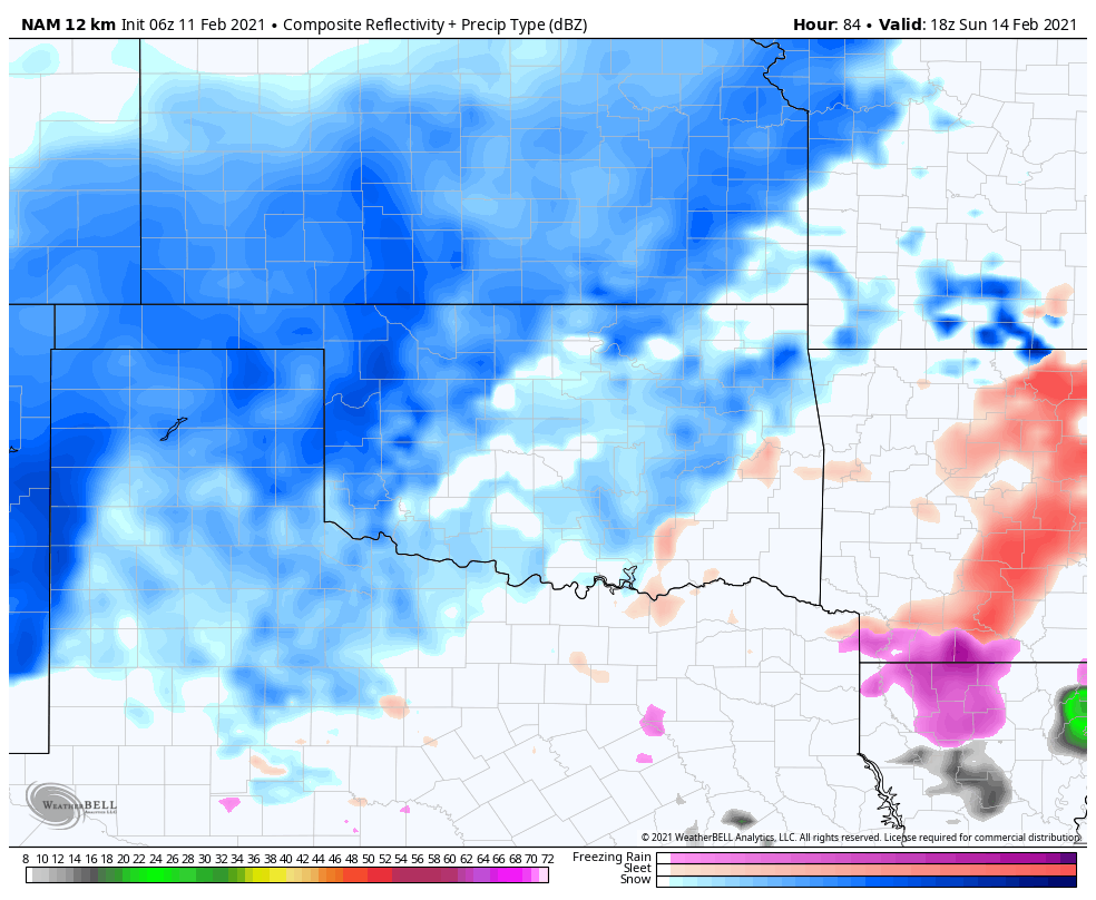
MO/KS/AR/OK 2020-2021 "Winter" Discussion
StormChazer replied to JoMo's topic in Central/Western States
Hour 84 of the NAM.
-
MO/KS/AR/OK 2020-2021 "Winter" Discussion
StormChazer replied to JoMo's topic in Central/Western States
Here we are. -
MO/KS/AR/OK 2020-2021 "Winter" Discussion
StormChazer replied to JoMo's topic in Central/Western States
The Euro maintains! -
MO/KS/AR/OK 2020-2021 "Winter" Discussion
StormChazer replied to JoMo's topic in Central/Western States
You stop that. -
MO/KS/AR/OK 2020-2021 "Winter" Discussion
StormChazer replied to JoMo's topic in Central/Western States
Although not nearly as reliable as the 2 main runs. I’ll post the 18Z Euro run in an hour ish. -
MO/KS/AR/OK 2020-2021 "Winter" Discussion
StormChazer replied to JoMo's topic in Central/Western States
18Z keeps the hype train chugging. -
MO/KS/AR/OK 2020-2021 "Winter" Discussion
StormChazer replied to JoMo's topic in Central/Western States
Absolutely! Loving this!! -
MO/KS/AR/OK 2020-2021 "Winter" Discussion
StormChazer replied to JoMo's topic in Central/Western States
GFS looking like it's going to be another solid run. -
MO/KS/AR/OK 2020-2021 "Winter" Discussion
StormChazer replied to JoMo's topic in Central/Western States
One of us...one of us... -
MO/KS/AR/OK 2020-2021 "Winter" Discussion
StormChazer replied to JoMo's topic in Central/Western States
TSA recent forecast discussion. They're definitely buying into it. "Now to the meat of this forecast, and the bad news. The GFS and ECMWF have remained amazingly consistent, especially given the time range of the forecast, regarding the next storm to affect the Plains Sunday into Monday. Both models paint considerable QPF over a deepening arctic air mass over the region. Snow ratios from the NBM look underdone given how cold this air mass is, and will thus use a 15-20 to 1 ratio from the GFS/EC. Since the snow will be more powdery, winds will be blowing from the arctic high building south, and snow rates could be heavy at times, the potential is there for a highly impactful winter storm early next week. Travel could be shut down over a large area. Power outages could occur when winds pick up due to the residual ice on the lines from the recent weather. So this storm has the potential to be a big deal. Forecast snow amounts were increased. Another system could affect the region by next Wednesday, potentially bringing more snow, but we have time to watch this. This week could go down in the memory books weather wise, for length of time below freezing and the winter weather impacts, among other things. There is hope on the distant horizon however. This blocking pattern that has supported arctic intrusions into the CONUS is expected to break down by the latter part of next week and become progressive. This should lock the cold air to the north and allow for more downslope flow and warmer temps. But, again, this is probably a week or more away." -
MO/KS/AR/OK 2020-2021 "Winter" Discussion
StormChazer replied to JoMo's topic in Central/Western States
There it is...... -
MO/KS/AR/OK 2020-2021 "Winter" Discussion
StormChazer replied to JoMo's topic in Central/Western States
I used to be a lurker for a long time, but am so glad I started contributing and speaking up. It's a small community, but love getting to gush about weather to people who actually care! The ice was definitely under done. Up here in Owasso we got nearly .5 inch of ice on many surfaces. and I have to be extremely careful trying to get out of my neighborhood. That run, even though it's likely la la land, half of that isn't out of the realm of possibility.....we could legitimately give the 2011storm a run for it's money, should the current runs hold(a lot can happen in 4 days). -
MO/KS/AR/OK 2020-2021 "Winter" Discussion
StormChazer replied to JoMo's topic in Central/Western States
No text needed.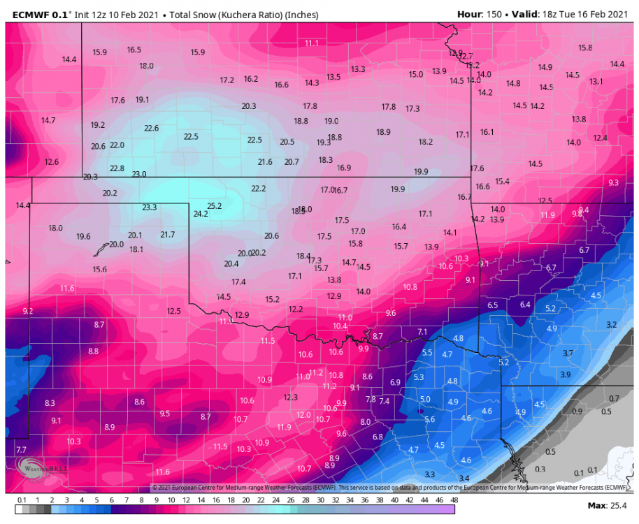
-
MO/KS/AR/OK 2020-2021 "Winter" Discussion
StormChazer replied to JoMo's topic in Central/Western States
Mike and Aaron are my go-to's. Haven't ever given David Payne a watch. Will do now! Hope he's right! -
MO/KS/AR/OK 2020-2021 "Winter" Discussion
StormChazer replied to JoMo's topic in Central/Western States
12Z GFS Kuchera -
MO/KS/AR/OK 2020-2021 "Winter" Discussion
StormChazer replied to JoMo's topic in Central/Western States
Yeah, some, but not much. -
MO/KS/AR/OK 2020-2021 "Winter" Discussion
StormChazer replied to JoMo's topic in Central/Western States
06Z GFS compared to 00Z Euro Kuchera snow totals for early next week system. -
MO/KS/AR/OK 2020-2021 "Winter" Discussion
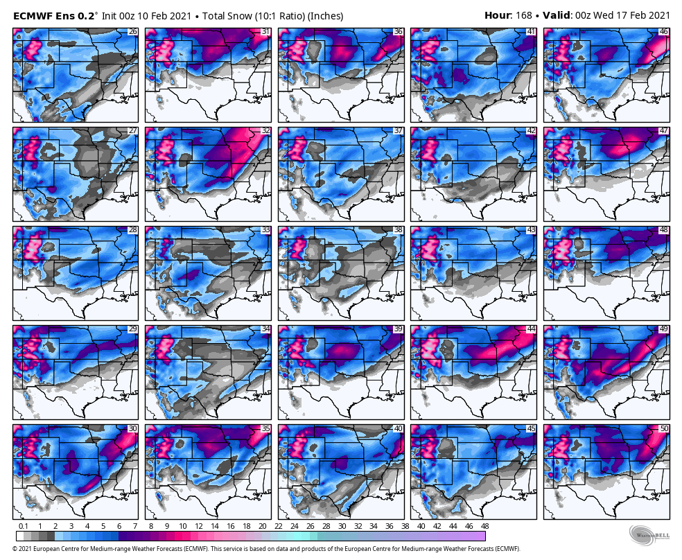
StormChazer replied to JoMo's topic in Central/Western States
Here are the members for just this Monday ish system. Keep in mind these are just showing the 10:1 ratio.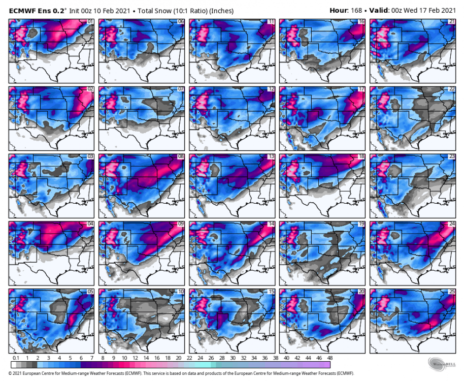

-
MO/KS/AR/OK 2020-2021 "Winter" Discussion
StormChazer replied to JoMo's topic in Central/Western States
Oh Euro........ Standard 10:1 Kuchera. -
MO/KS/AR/OK 2020-2021 "Winter" Discussion
StormChazer replied to JoMo's topic in Central/Western States
Yeah, this is just downright silly. Not gonna happen, but still silly.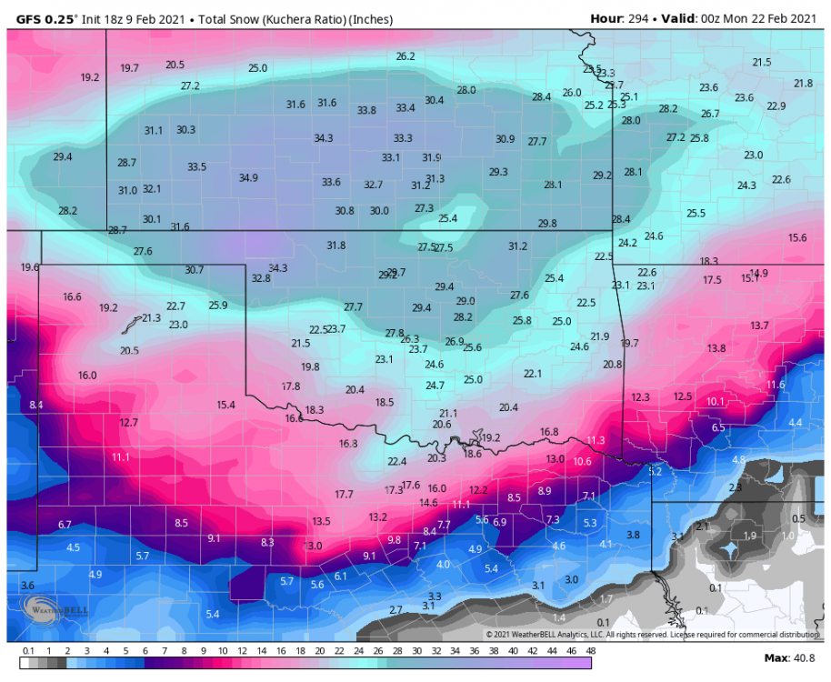
-
MO/KS/AR/OK 2020-2021 "Winter" Discussion
StormChazer replied to JoMo's topic in Central/Western States
Yeah, drops another 3.5 inches in the normal 10:1 ratio, but 9 inches in Kuchera. -
MO/KS/AR/OK 2020-2021 "Winter" Discussion
StormChazer replied to JoMo's topic in Central/Western States
GFS staying with it. Lighter amounts, but still a nice 3 to 4 inches. -
MO/KS/AR/OK 2020-2021 "Winter" Discussion
StormChazer replied to JoMo's topic in Central/Western States
Yeah, this is a pretty awesome image here. This is the 50 euro members mean snowfall over the entire run. This is from 3 or 4 separate storm systems rolling through from late this weekend throughout next week. Normally a high average total like this is because there's a storm 1-2 days out and its got some good precip so all the members converge. But to see it this high because of a lengthy period of snow is more akin to the NE, not down here. Bring it on! -
MO/KS/AR/OK 2020-2021 "Winter" Discussion
StormChazer replied to JoMo's topic in Central/Western States
Canadian might be looking more GFS-ish at hour 90. But will know soon. Edit: Looks like a nudge towards the GFS, but still hasn't bought in on the solution.