StormChazer
-
Posts
1,231 -
Joined
-
Last visited
Content Type
Profiles
Blogs
Forums
American Weather
Media Demo
Store
Gallery
Everything posted by StormChazer
-

MO/KS/AR/OK 2020-2021 "Winter" Discussion
StormChazer replied to JoMo's topic in Central/Western States
Yeah, I'd say the Canadian for sure. It had the most consistent performance, and although it did include Tulsa in the Frz Rain, it did start to back off with time. And no model can get that down to the exact mile. -
MO/KS/AR/OK 2020-2021 "Winter" Discussion
StormChazer replied to JoMo's topic in Central/Western States
Socked in this band pretty good, already picked up about an inch and a half, maybe 2. Roads completely covered.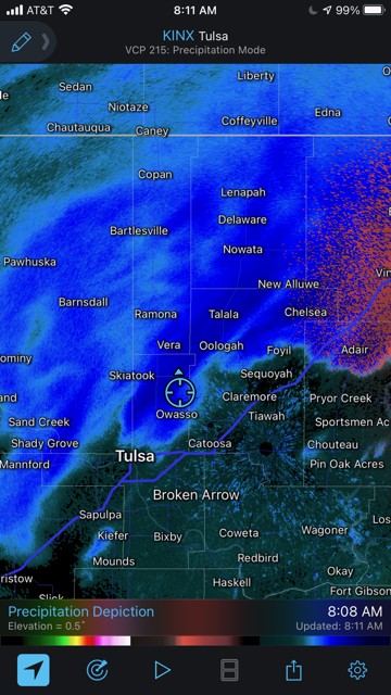
-
MO/KS/AR/OK 2020-2021 "Winter" Discussion
StormChazer replied to JoMo's topic in Central/Western States
I love that place! Wife and I will take an occasional weekend away out there. That’s a lot! -
MO/KS/AR/OK 2020-2021 "Winter" Discussion
StormChazer replied to JoMo's topic in Central/Western States
SNOWING HEAVY! -
MO/KS/AR/OK 2020-2021 "Winter" Discussion
StormChazer replied to JoMo's topic in Central/Western States
Where is "here"? Back home? -
MO/KS/AR/OK 2020-2021 "Winter" Discussion
StormChazer replied to JoMo's topic in Central/Western States
Drove to Skiatook, couldn't spot any ice. Might be treetops though. -
MO/KS/AR/OK 2020-2021 "Winter" Discussion
StormChazer replied to JoMo's topic in Central/Western States
Talala and Skiatook aren't reporting winds anymore on mesonet. That means the equipment has ice build up on it. -
MO/KS/AR/OK 2020-2021 "Winter" Discussion
StormChazer replied to JoMo's topic in Central/Western States
Thanks for the scouting! I may hop on the car and drive over to Skiatook to see what it's like there, no ice yet in Collinsville, must be just a few decimal points above freezing here. 31.6 in Skiatook 32.7 in Tulsa. -
MO/KS/AR/OK 2020-2021 "Winter" Discussion
StormChazer replied to JoMo's topic in Central/Western States
Hahaha, I thought about how it sounded after the fact lol. -
MO/KS/AR/OK 2020-2021 "Winter" Discussion
StormChazer replied to JoMo's topic in Central/Western States
Wow, no kidding! Drops 3 inches of sleet in North Tulsa as well as a couple inches of snow. Which I'd be more than happy with. But man...10+ inches of snow? Whew! -
MO/KS/AR/OK 2020-2021 "Winter" Discussion
StormChazer replied to JoMo's topic in Central/Western States
Stuck my fancy meat probe thermometer in my mailbox with the tip sticking out. 32 Degrees at my house. -
MO/KS/AR/OK 2020-2021 "Winter" Discussion
StormChazer replied to JoMo's topic in Central/Western States
BIG difference.
-
MO/KS/AR/OK 2020-2021 "Winter" Discussion
StormChazer replied to JoMo's topic in Central/Western States
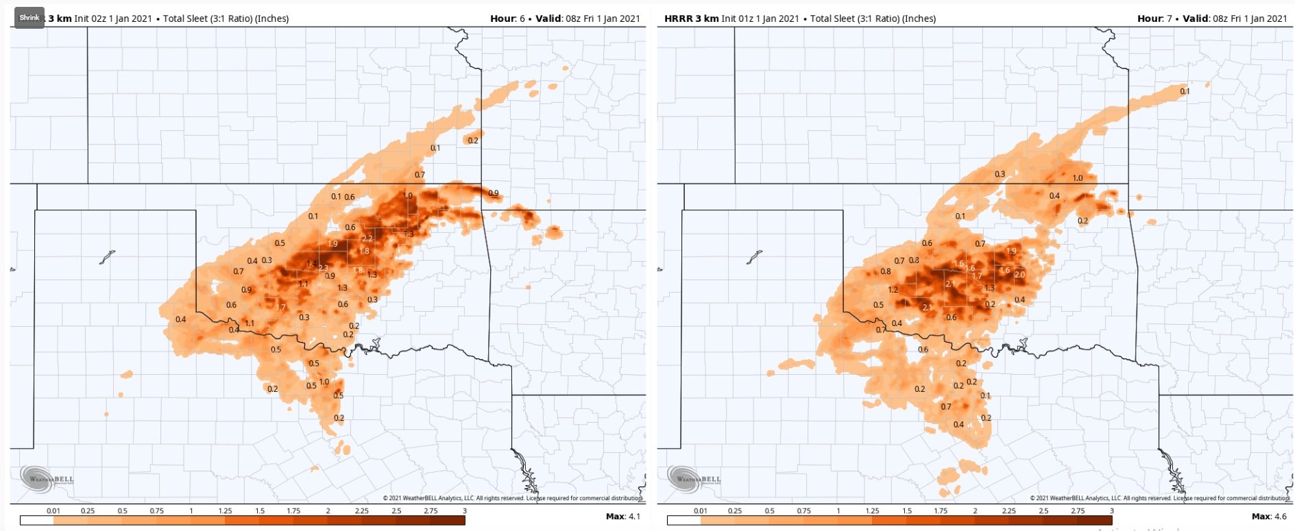
Jump in the new run of the HRRR. Throwing Tulsa into the sleet by 10 PM instead of 1 AM. -
MO/KS/AR/OK 2020-2021 "Winter" Discussion
StormChazer replied to JoMo's topic in Central/Western States
31.9 in Skiatook now, looks like Tulsa is at 33.3. -
MO/KS/AR/OK 2020-2021 "Winter" Discussion
StormChazer replied to JoMo's topic in Central/Western States
Getting close.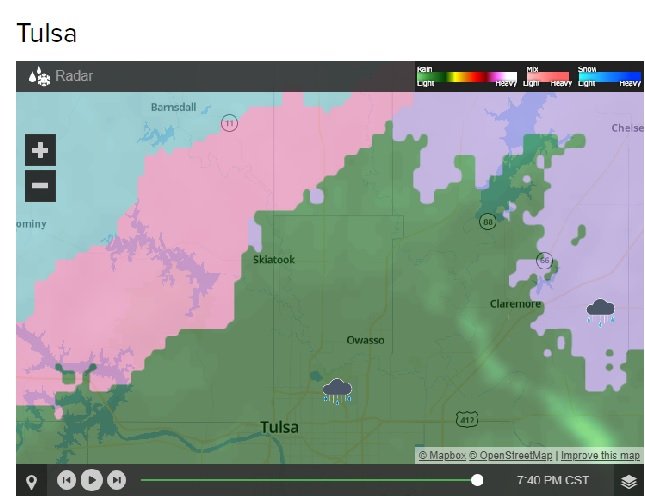
-
MO/KS/AR/OK 2020-2021 "Winter" Discussion
StormChazer replied to JoMo's topic in Central/Western States
32 in Skiatook now, just 10 miles way from me. -
MO/KS/AR/OK 2020-2021 "Winter" Discussion
StormChazer replied to JoMo's topic in Central/Western States
Thanks for the update! -
MO/KS/AR/OK 2020-2021 "Winter" Discussion
StormChazer replied to JoMo's topic in Central/Western States
Wow! Small world! We are in Brookfield Crossing at N 115th E Ave. -
MO/KS/AR/OK 2020-2021 "Winter" Discussion
StormChazer replied to JoMo's topic in Central/Western States
Also, you aren’t kidding, you really do live like right next to me. I’m about 1/2 a mile away from that neighborhood Walmart off 116th. -
MO/KS/AR/OK 2020-2021 "Winter" Discussion
StormChazer replied to JoMo's topic in Central/Western States
Yeah, it's like christmas lights blinking around lol, pink, then blue, then green, etc. -
MO/KS/AR/OK 2020-2021 "Winter" Discussion
StormChazer replied to JoMo's topic in Central/Western States
Not lining up as of right now.
-
MO/KS/AR/OK 2020-2021 "Winter" Discussion
StormChazer replied to JoMo's topic in Central/Western States
Don't you put that evil on me! -
MO/KS/AR/OK 2020-2021 "Winter" Discussion
StormChazer replied to JoMo's topic in Central/Western States
100% this. What's the criteria anyhow? Greater than 1/2 the county to be included? 1/3? It's very unclear and doesn't paint a proper picture. What if I end up, in Collinsville, getting an ice storm while Bixby skirts by with cold rain? If I wasn't weather savvy, I would be surprised because there was no advisory or warning due to the current format. -
MO/KS/AR/OK 2020-2021 "Winter" Discussion
StormChazer replied to JoMo's topic in Central/Western States
Oh look at that. -
MO/KS/AR/OK 2020-2021 "Winter" Discussion
StormChazer replied to JoMo's topic in Central/Western States
Hahah, yeah, Dew point temps are in the mid to upper 20's in NE OK, with those NE winds, that's going to mitigate that from moderating much. I really do think the eventual freeze line is going to be along Wagoner county east of Tulsa.