StormChazer
-
Posts
1,231 -
Joined
-
Last visited
Content Type
Profiles
Blogs
Forums
American Weather
Media Demo
Store
Gallery
Everything posted by StormChazer
-

MO/KS/AR/OK 2020-2021 "Winter" Discussion
StormChazer replied to JoMo's topic in Central/Western States
6Z RDPS a little more East than it’s 12Z run and the 6Z GFS is a hair south. -
MO/KS/AR/OK 2020-2021 "Winter" Discussion
StormChazer replied to JoMo's topic in Central/Western States
Considerable jump east, and the Euro has been following it recently. FWIW Aaron Tuttle seems to think the Euro is too far west and will move east again. He also thinks there's good merit to what the HRRR was picking up on, on Wednesday. -
MO/KS/AR/OK 2020-2021 "Winter" Discussion
StormChazer replied to JoMo's topic in Central/Western States
Can’t take the long range HRRR too seriously, but it’s certainly worth watching! Because that’s some decently heavy precip! -
MO/KS/AR/OK 2020-2021 "Winter" Discussion
StormChazer replied to JoMo's topic in Central/Western States
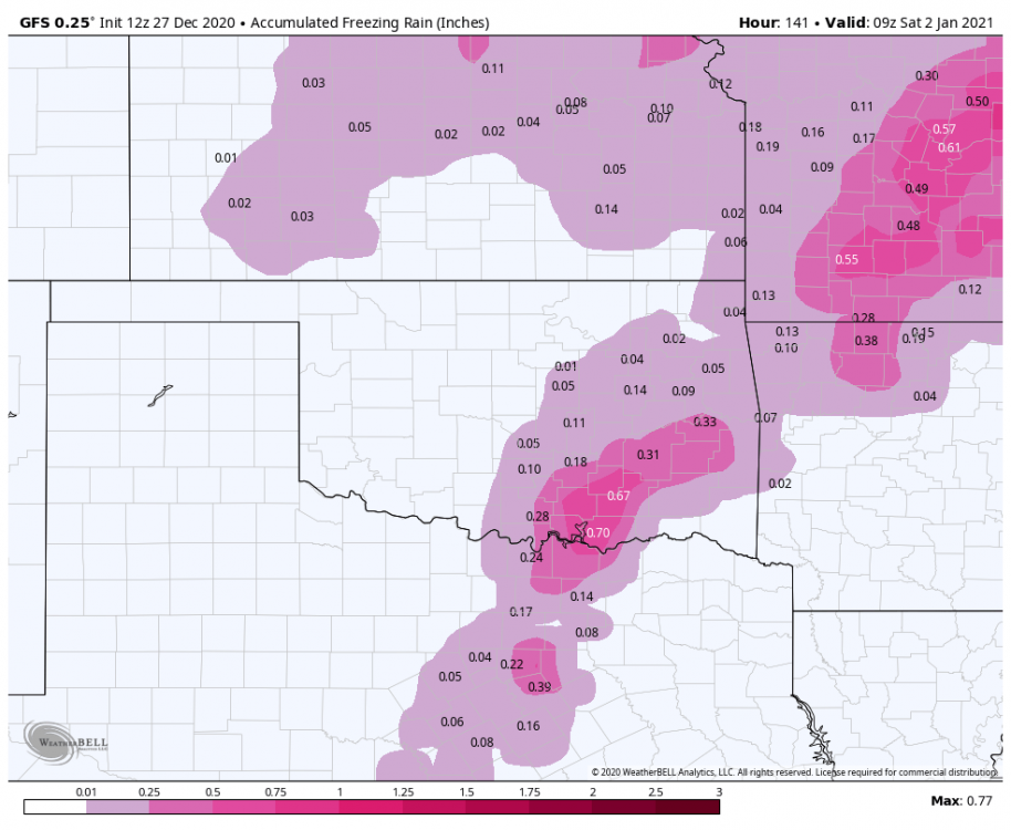
I'm gonna weenie post really quick and state something completely unfounded by science. The Canadian was the first to sniff this out, so I'm gonna ride it all the way. Now for the unfounded, weenie part. This just feels like a bad ice storm for Tulsa. -
MO/KS/AR/OK 2020-2021 "Winter" Discussion
StormChazer replied to JoMo's topic in Central/Western States
18Z NAM looks nearly identical. -
MO/KS/AR/OK 2020-2021 "Winter" Discussion
StormChazer replied to JoMo's topic in Central/Western States
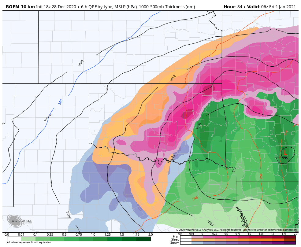
18Z RDPS smoking Tulsa with freezing rain.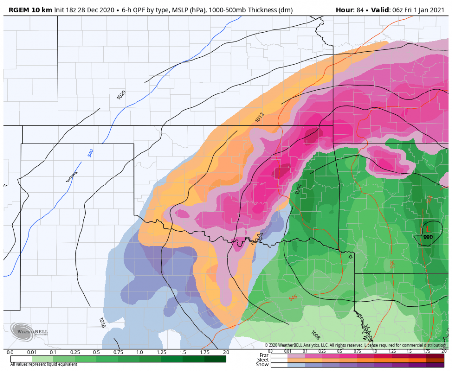
-
MO/KS/AR/OK 2020-2021 "Winter" Discussion
StormChazer replied to JoMo's topic in Central/Western States
Hr 55 on the Euro and it's looking a little cooler right now than the 00Z run last night. Or maybe it's just the front is coming through quicker. -
MO/KS/AR/OK 2020-2021 "Winter" Discussion
StormChazer replied to JoMo's topic in Central/Western States
-
MO/KS/AR/OK 2020-2021 "Winter" Discussion
StormChazer replied to JoMo's topic in Central/Western States
TSA does address the warm air. "The Wed night through Friday forecast remains difficult. Good consensus does exist in a closed low developing within the base of the broader trough axis by early Thursday then lifting northeastward into the Missouri Valley by Friday afternoon. The much more uncertain aspect remains the exact track and the associated influence on thermal profiles and respective precip types as the system passes. A clear westward trend continues within the operational ECMWF while the operational GFS remains on the eastern periphery of its ensemble suite. Furthermore the latest EC ensemble suite show a notable warming trend in the lowest levels compared to recent runs, all of which would favor the forecast leaning toward the stronger western solution of the upper low passage. The lack of a deep cold low level airmass in advance of the upper low also favors a warming thermal profile well west of the sfc low track. Noteworthy is the continued presence of the unseasonably high moisture content airmass and its likely influence in yielding a broader and heavier precip footprint within the western semicircle of the upper low. The forecast trending toward the warmer solution does limit snow potential but also raises the potential for an area of light to moderate freezing rain. Currently the favored region for notable ice accumulations would be across far NE OK into far NW AR. Obviously plenty of moving parts in this forecast scenario and the forecast should be expected to change." -
MO/KS/AR/OK 2020-2021 "Winter" Discussion
StormChazer replied to JoMo's topic in Central/Western States
6Z GFS nudged back west this morning from last night’s run. -
MO/KS/AR/OK 2020-2021 "Winter" Discussion
StormChazer replied to JoMo's topic in Central/Western States
Interesting run on the Euro. I thought after seeing the GFS and Canadian take an eastern solution, the Euro may nudge more eastward, but instead it went even further west...haha.. -
MO/KS/AR/OK 2020-2021 "Winter" Discussion
StormChazer replied to JoMo's topic in Central/Western States
Pretty par for the course that far out on the NAM -
MO/KS/AR/OK 2020-2021 "Winter" Discussion
StormChazer replied to JoMo's topic in Central/Western States
NAM is now biting on the closed low; first run to do so. -
MO/KS/AR/OK 2020-2021 "Winter" Discussion
StormChazer replied to JoMo's topic in Central/Western States
Tulsa NWS thoughts. It's a good read. "The late week system has changed greatly in the past 24 hours with even more agreement between the GFS and ECMWF runs. With this agreement comes a very messy forecast. Both the GFS and ECMWF are now showing a closed low developing over TX before wrapping up and moving sharply to the north either along the OK/AR border (ECMWF) or through eastern AR (GFS). The 12Z ECMWF is pretty similar to its 00Z counterpart but shifts the heavier snow band a tad west while the GFS saw a more noticeable shift to the west which suggests higher snow totals across NE OK and NW AR. One other thing to note with this system and has been a headache to forecast for - will be the potential of a warm layer between 925 and 850mb which will play significant role in precipitation type and amounts starting Wednesday evening and continuing through Friday morning. Both models wobble the 850mb freezing line along the I-44 corridor Thursday morning before retreating westward briefly Thursday afternoon (as the upper low approaches and wraps warm air around). This wobbling of 850mb line with temps below freezing at the surface will allow for mixed precipitation with sleet and freezing rain possible. Snow amounts will obviously be impacted based on the amount of sleet and freezing rain (or even just rain) that falls. 850Mb temps then fall quickly through the overnight hours as the upper low passes somewhere between W AR and E AR. This would be the best opportunity for accumulating snow across the area with NE OK and NW AR likely seeing the best chances for accumulating snow. With this update and long story short, opted to enhance ice totals across SE OK and NW AR closer to the track of the upper low and upped snowfall totals across the area with the most notable increase in snow totals across NE OK mainly Thursday evening and overnight as the atmospheric column cools below freezing. There are still many uncertainties with this forecast such as where ice could fall/accumulate and how much snow we could ultimately see across the area thus this forecast will be refined over the next couple of days." -TSA TLDR: There will be a lot of snow where the sleet and freezing rain don't limit amounts. -
MO/KS/AR/OK 2020-2021 "Winter" Discussion
StormChazer replied to JoMo's topic in Central/Western States
I'm not sure that the members show things like ice/sleet. Someone more experienced with models would have to answer that, but I've never found it. -
MO/KS/AR/OK 2020-2021 "Winter" Discussion
StormChazer replied to JoMo's topic in Central/Western States
12Z Euro Members. -
MO/KS/AR/OK 2020-2021 "Winter" Discussion
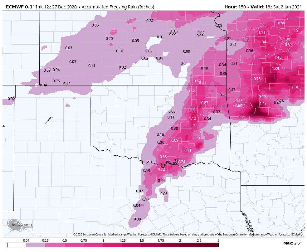
StormChazer replied to JoMo's topic in Central/Western States
Lays down almost an inch of ice in Tulsa followed by 7 inches of snow. I’m cautiously optimistic right now. Just East of the highest totals on the Euro, and just west of the highest totals on the GFS & Canadian. Right where I want to be 4 days out from the onset of this storm.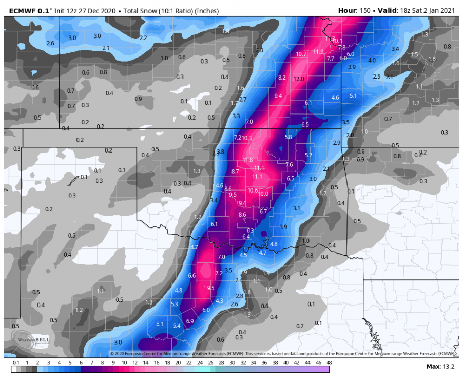

-
MO/KS/AR/OK 2020-2021 "Winter" Discussion
StormChazer replied to JoMo's topic in Central/Western States
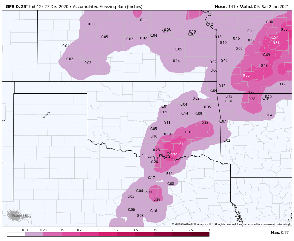
12Z Euro going further west. -
MO/KS/AR/OK 2020-2021 "Winter" Discussion
StormChazer replied to JoMo's topic in Central/Western States
Well here’s to hoping not, because the Canadian cut me deep that run. -
MO/KS/AR/OK 2020-2021 "Winter" Discussion
StormChazer replied to JoMo's topic in Central/Western States
We officially have all the major players set on this solution. Now we start refining the amounts and exact locations.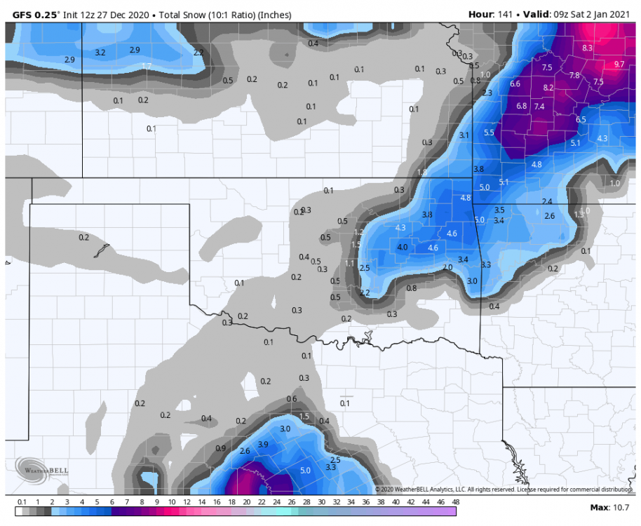
-
MO/KS/AR/OK 2020-2021 "Winter" Discussion
StormChazer replied to JoMo's topic in Central/Western States
GFS looks like it may be hopping on board now as well. -
MO/KS/AR/OK 2020-2021 "Winter" Discussion
StormChazer replied to JoMo's topic in Central/Western States
It goes out 90 hours. -
MO/KS/AR/OK 2020-2021 "Winter" Discussion
StormChazer replied to JoMo's topic in Central/Western States
So FWIW here was the 6Z Euro. definitely more snow on the back end already.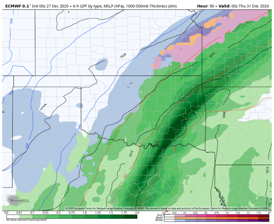
-
MO/KS/AR/OK 2020-2021 "Winter" Discussion
StormChazer replied to JoMo's topic in Central/Western States
12Z Euro....I'll take one of these please. -
MO/KS/AR/OK 2020-2021 "Winter" Discussion
StormChazer replied to JoMo's topic in Central/Western States