StormChazer
-
Posts
1,231 -
Joined
-
Last visited
Content Type
Profiles
Blogs
Forums
American Weather
Media Demo
Store
Gallery
Everything posted by StormChazer
-

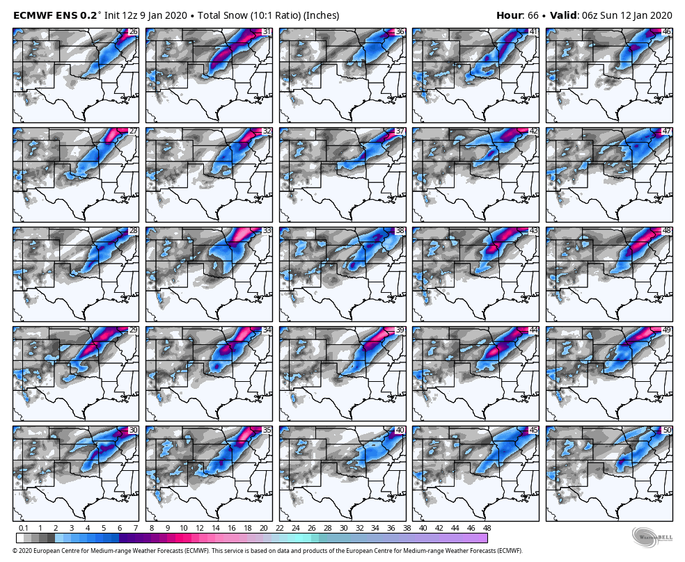
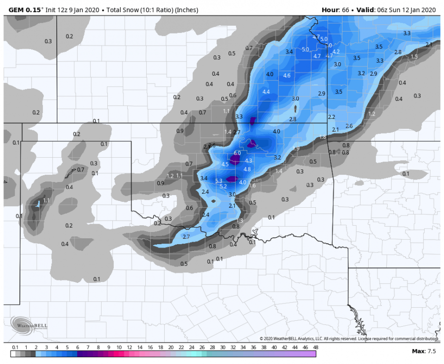
MO/KS/AR/OK 2019-2020 Winter Wonderland Discussion
StormChazer replied to JoMo's topic in Central/Western States
Last night's run for reference.
.thumb.png.daa88153288987a9d70122f75747b53d.png)
-
MO/KS/AR/OK 2019-2020 Winter Wonderland Discussion
StormChazer replied to JoMo's topic in Central/Western States
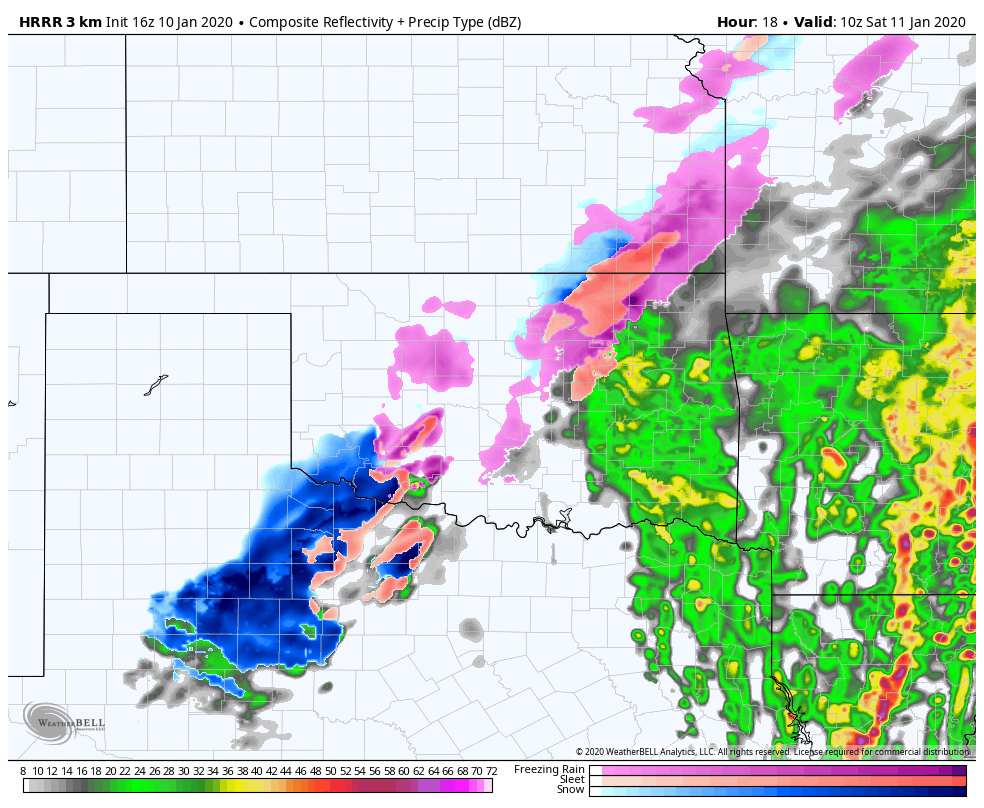
12Z Euro is reflecting the 16Z HRRR right now. -
MO/KS/AR/OK 2019-2020 Winter Wonderland Discussion
StormChazer replied to JoMo's topic in Central/Western States
What I'm getting at is, here is the 12Z HRRR run and the latest 16Z both at 4AM tomorrow morning. In the 12Z it appears that it's already beginning to wrap up to pump out the totals in N OK, but in the 16Z it's practically entirely in NW TX. What does this mean, if anything at all? Or am I obsessing, lol.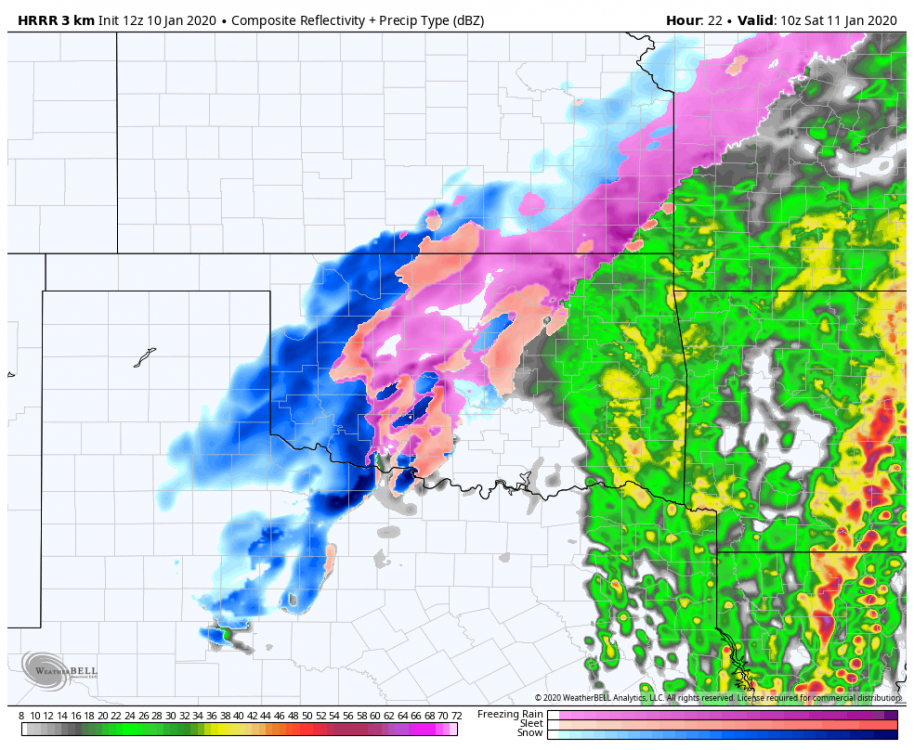

-
MO/KS/AR/OK 2019-2020 Winter Wonderland Discussion
StormChazer replied to JoMo's topic in Central/Western States
Question for those more meteorologically inclined. What is it going to take to eek that deformation band more east? A more negatively tilted trough? more southern storm track? Etc Just trying to figure out what I should be on the lookout for when watching the HRRR. -
MO/KS/AR/OK 2019-2020 Winter Wonderland Discussion
StormChazer replied to JoMo's topic in Central/Western States
It's so close to Tulsa it HURTS. I'm just praying that when the storm develops that deformation band is just 20 miles closer....I don't need to be dead center with 6+ inches, I just want 3. If I didn't have a 6 month old that hardly sleeps, I'd just get in my car and chase some snow! To think....I could chase tornadoes and then snow just hours apart in the same geographical area! -
MO/KS/AR/OK 2019-2020 Winter Wonderland Discussion
StormChazer replied to JoMo's topic in Central/Western States

-
MO/KS/AR/OK 2019-2020 Winter Wonderland Discussion
StormChazer replied to JoMo's topic in Central/Western States
I know these 18Z runs include old upper air data(aka not the on shore sampled stuff) so I’d say it’s not locked in. Plus, they’re literally going to wait until the HRRR is in 18 hr range to make those calls. -
MO/KS/AR/OK 2019-2020 Winter Wonderland Discussion
StormChazer replied to JoMo's topic in Central/Western States
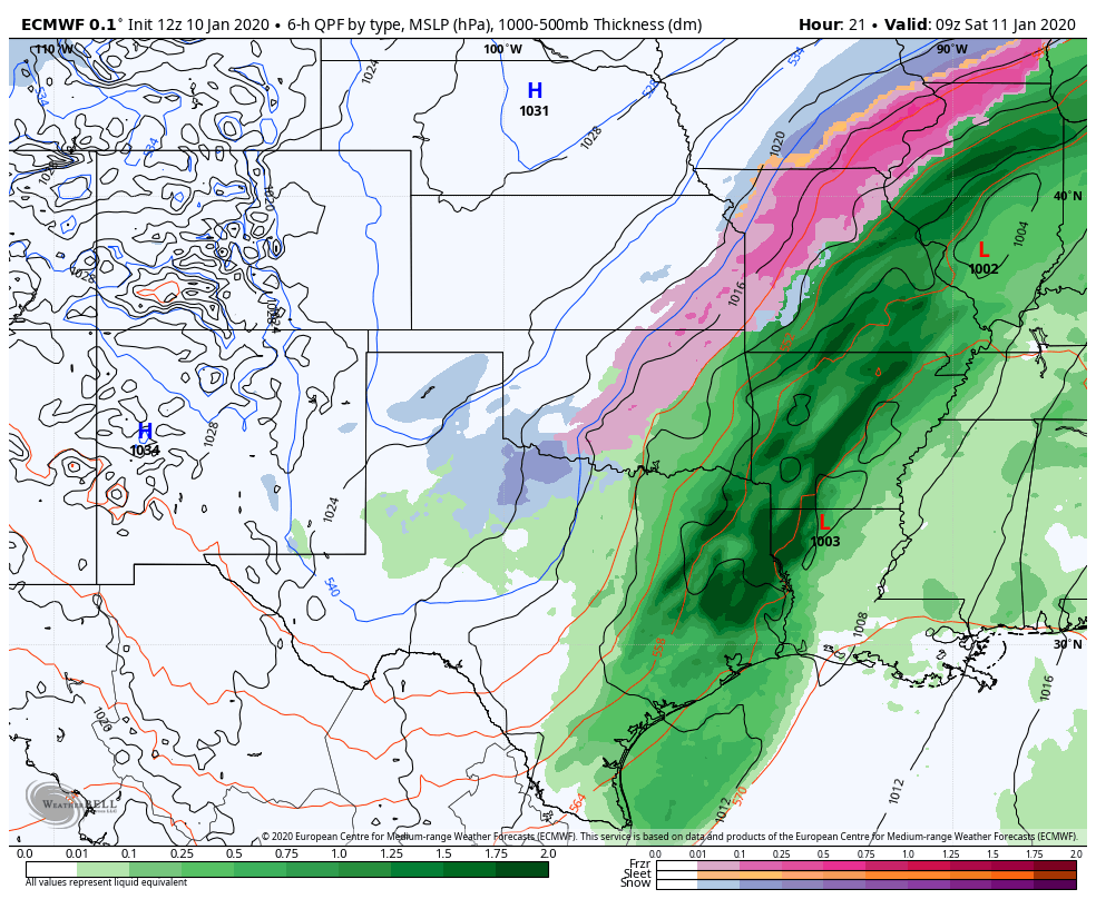
The cold front finally gets a push into Northeast Oklahoma Friday afternoon and through Northwest Arkansas late Friday evening/overnight Friday night as the main upper low shifts eastward into Texas. Behind the cold front...much colder air is forecast to filter into the region Friday night which will allow for precip to transition over to a wintry mix of freezing rain and sleet into Saturday morning from northwest to southeast. The greater wintry mix is expected across Northeast Oklahoma before the nose of warmer temps aloft can be eroded. Ice accumulations of a few hundredths of an inch will be possible with to up toward a tenth of an inch for some location along the Oklahoma Kansas border. Surface temps will continue to fall Friday night through much of the Saturday as the upper low shifts east into the CWA and then Northeast into Missouri Saturday afternoon. By Saturday afternoon temps in the 20s to mid 30s are forecast from north to south. These temp profiles combined with moisture wrapping around the upper low will aid in a transition to all snow during the day Saturday from west to east before tapering off and exiting by Saturday evening. Also behind the exiting low...gusty northerly winds in the 20 to 30+ mph range will be possible which could create areas of blowing snow Saturday morning. At this time...snow accumulations of 1 to 3 with locally higher amounts could be possible along and north of I-44 with around 1 inch or so for far Northwest Arkansas before the precip ends. With these amounts and also the possible ice amounts a winter storm watch will be issued across parts of the Oklahoma Kansas border in Northeast Oklahoma Friday night into Saturday. -
MO/KS/AR/OK 2019-2020 Winter Wonderland Discussion
StormChazer replied to JoMo's topic in Central/Western States
Tulsa just barely excluded from Winter Storm Watch. -
MO/KS/AR/OK 2019-2020 Winter Wonderland Discussion
StormChazer replied to JoMo's topic in Central/Western States
I've been watching it past few runs. I haven't said much because, well...1 thing at a time right? But that is a mean ice storm, not to mention afterwards there's 1 day above freezing and then it doesn't get above freezing for a while. -
MO/KS/AR/OK 2019-2020 Winter Wonderland Discussion
StormChazer replied to JoMo's topic in Central/Western States
Well, hellooo beautiful. -
MO/KS/AR/OK 2019-2020 Winter Wonderland Discussion
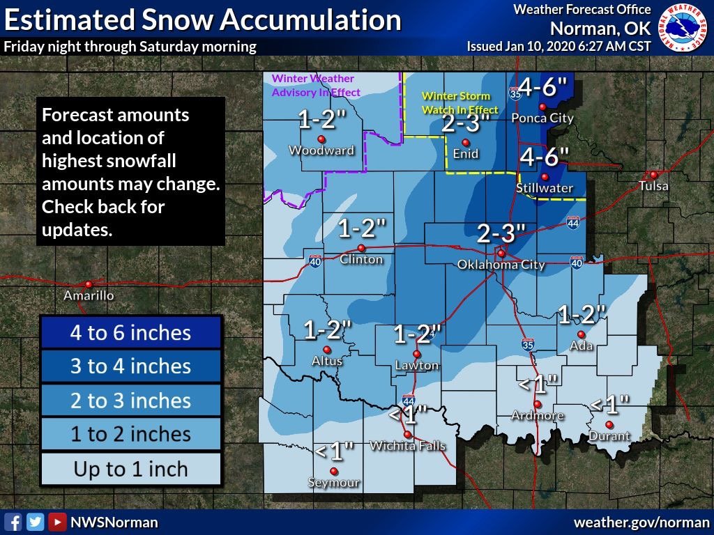
StormChazer replied to JoMo's topic in Central/Western States
OKC updated their snowfall map, also shows an eastward trend.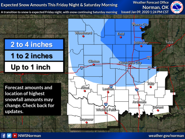
-
MO/KS/AR/OK 2019-2020 Winter Wonderland Discussion
StormChazer replied to JoMo's topic in Central/Western States
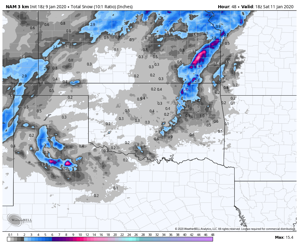
I should also note that this run of the NAM does NOT include the new upper air data sampled from this morning. So food for thought. -
MO/KS/AR/OK 2019-2020 Winter Wonderland Discussion
StormChazer replied to JoMo's topic in Central/Western States
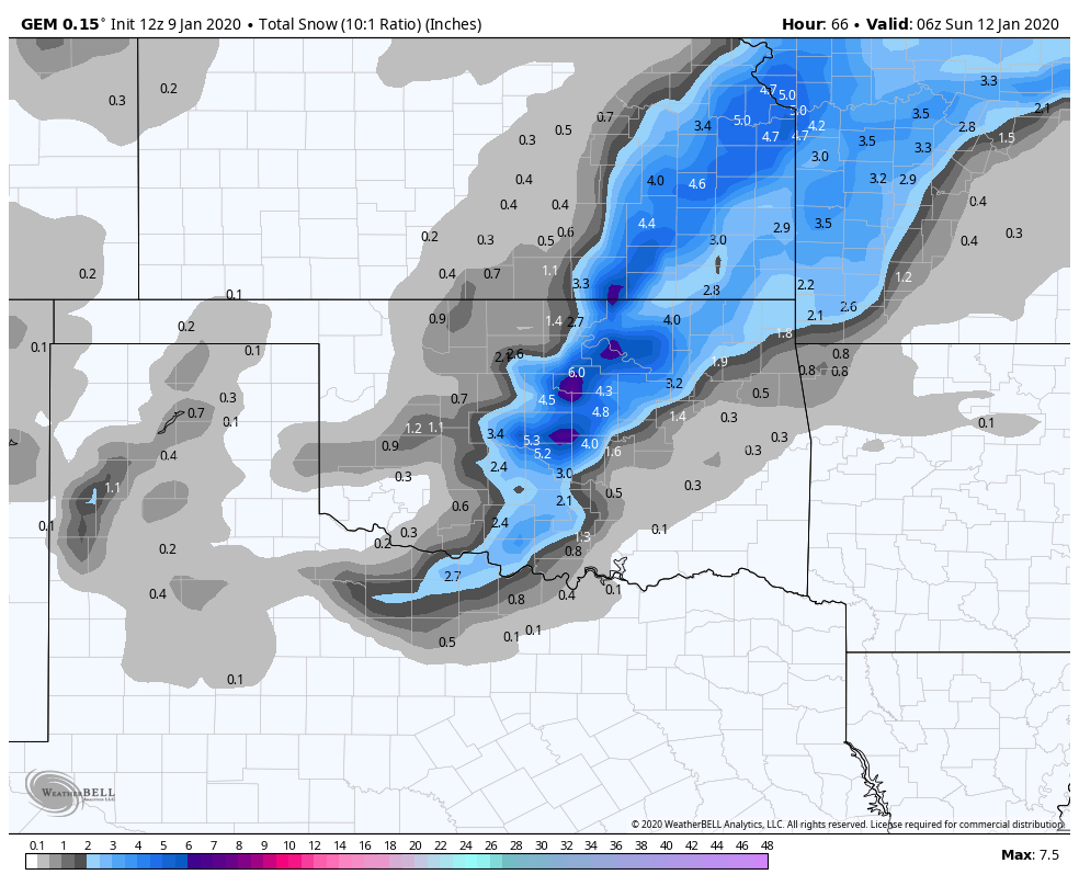
This isn't all the way out yet, so don't fret MO peeps. But it does pick up on that deformation zone and puts it pretty much over NE OK. I'm more interested in that trend east than anything else. That area used to be 70 miles west.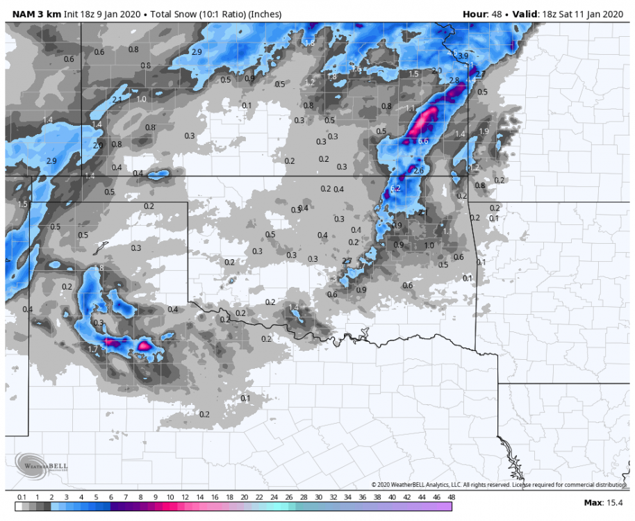
-
MO/KS/AR/OK 2019-2020 Winter Wonderland Discussion
StormChazer replied to JoMo's topic in Central/Western States
Now we wait to see who follows suit. Will Tulsa have the gumption to issue a winter storm watch or leave it all as advisories? -
MO/KS/AR/OK 2019-2020 Winter Wonderland Discussion
StormChazer replied to JoMo's topic in Central/Western States
Ask and you shall receive.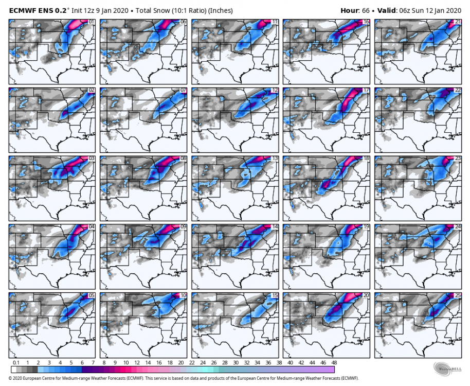
-
MO/KS/AR/OK 2019-2020 Winter Wonderland Discussion
StormChazer replied to JoMo's topic in Central/Western States
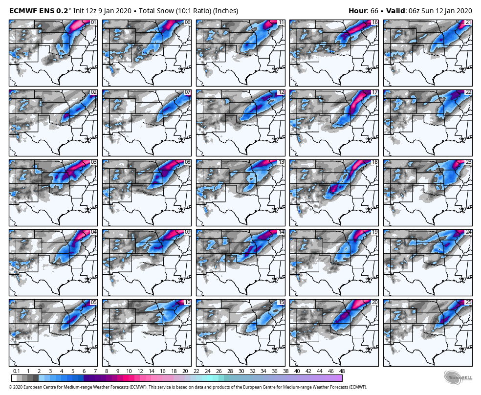
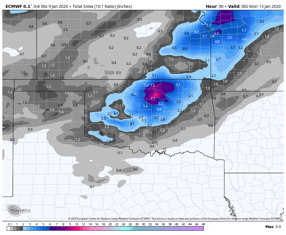
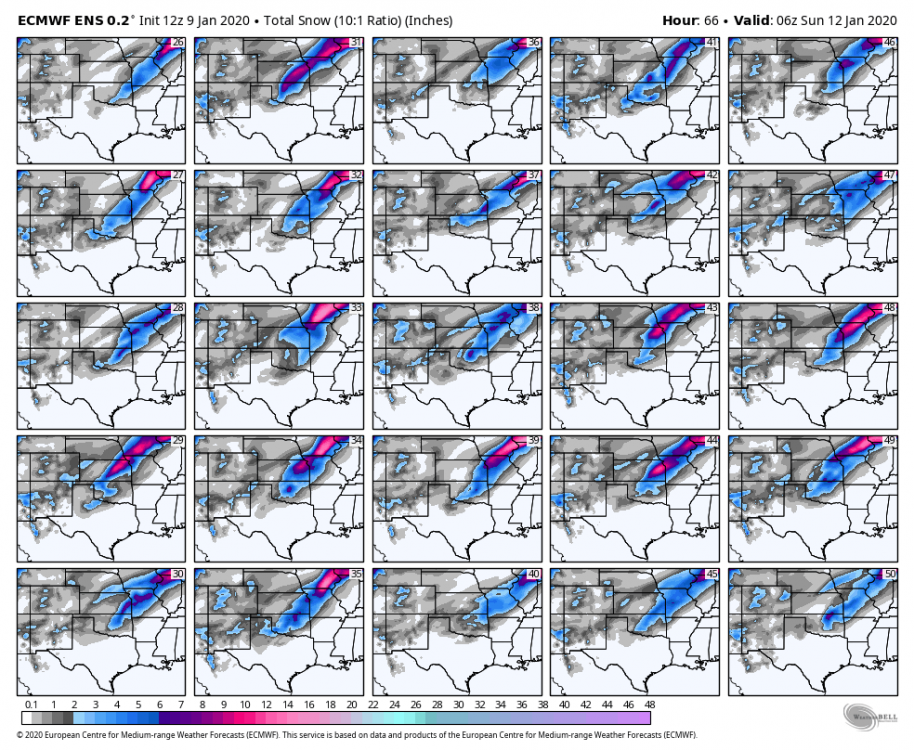
Btw, the Euro members supported the OP run highly, if not a little more east. -
MO/KS/AR/OK 2019-2020 Winter Wonderland Discussion
StormChazer replied to JoMo's topic in Central/Western States
As a Tulsan...I'm very invested in this recent Euro run, as it drops an additional heavy swath of snow over us, separate from the main one to the NW. -
MO/KS/AR/OK 2019-2020 Winter Wonderland Discussion
StormChazer replied to JoMo's topic in Central/Western States
Beat me to it! lol -
MO/KS/AR/OK 2019-2020 Winter Wonderland Discussion
StormChazer replied to JoMo's topic in Central/Western States
-
MO/KS/AR/OK 2019-2020 Winter Wonderland Discussion
StormChazer replied to JoMo's topic in Central/Western States
-
MO/KS/AR/OK 2019-2020 Winter Wonderland Discussion
StormChazer replied to JoMo's topic in Central/Western States
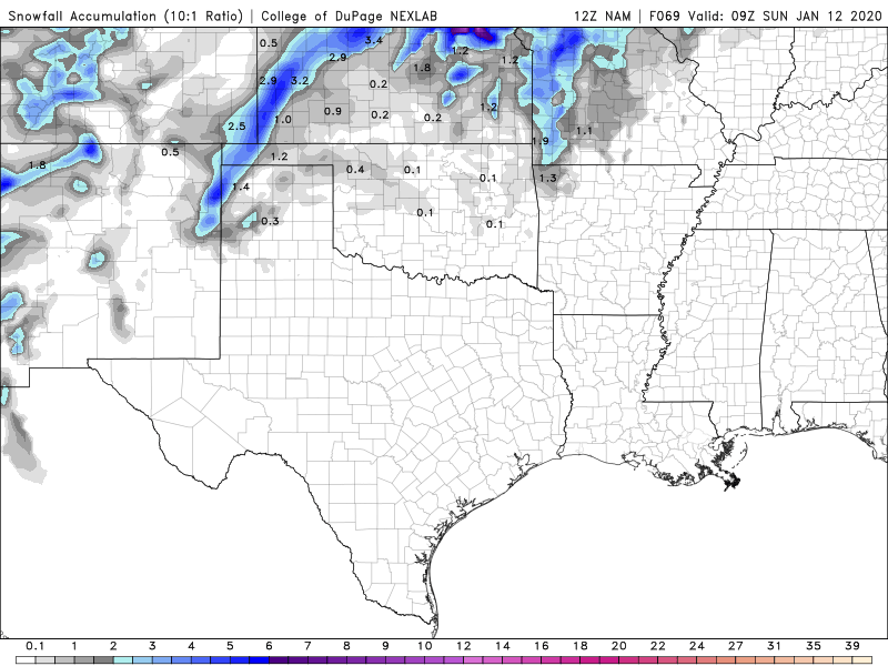
You aren't kidding...... Do we know if this NAM run includes sampling from the now, on-shore trough? -
MO/KS/AR/OK 2019-2020 Winter Wonderland Discussion
StormChazer replied to JoMo's topic in Central/Western States
12Z Nam is looking funny so far....very devoid. Edit: Up to hour 54 and looking like it may be a heavy Missouri hit? -
MO/KS/AR/OK 2019-2020 Winter Wonderland Discussion
StormChazer replied to JoMo's topic in Central/Western States
06Z Euro trends south a little.
-
MO/KS/AR/OK 2019-2020 Winter Wonderland Discussion
StormChazer replied to JoMo's topic in Central/Western States
Canadian with a considerable shift South and East. That, combined with the latest gfs has me feeling good about the trend. Now we wait for the almighty Euro.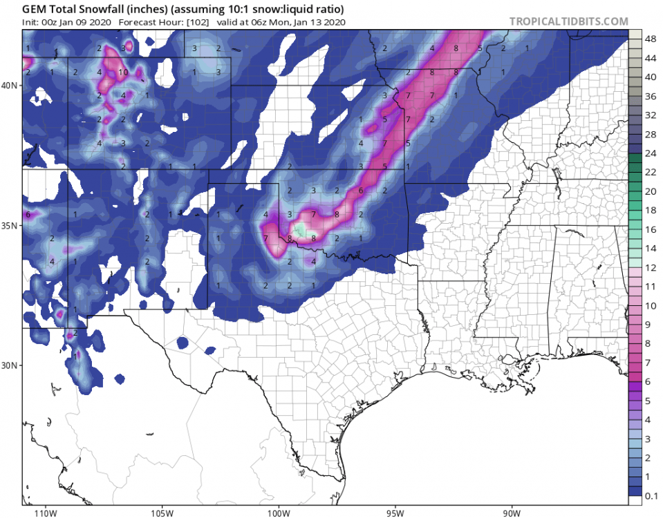
.png.91426966528cf430173f622722ec007d.png)