StormChazer
-
Posts
1,231 -
Joined
-
Last visited
Content Type
Profiles
Blogs
Forums
American Weather
Media Demo
Store
Gallery
Everything posted by StormChazer
-

MO/KS/AR/OK 2019-2020 Winter Wonderland Discussion
StormChazer replied to JoMo's topic in Central/Western States
Honestly, it's not much but I think it's a step in the right direction, if ever so small. Looks a touch more negatively tilted. 18Z 12Z.thumb.png.0e83a0d7cac0fc5815fd241a6bea4b4a.png)

-
MO/KS/AR/OK 2019-2020 Winter Wonderland Discussion
StormChazer replied to JoMo's topic in Central/Western States
For those interested..thumb.png.f43c35a8180d1fad67e536d63bcf50bc.png)
.thumb.png.e1f0a631cd43584d659b006121d079b2.png)
-
MO/KS/AR/OK 2019-2020 Winter Wonderland Discussion
StormChazer replied to JoMo's topic in Central/Western States
Euro Ensembles now MUCH more supportive of the OP. -
MO/KS/AR/OK 2019-2020 Winter Wonderland Discussion
StormChazer replied to JoMo's topic in Central/Western States
I had all but talked myself down before the midnight run last night, accepting that I'd likely see the Euro change it's mind, and not to get all sad. But it stayed the course, now we wait and see if the noon run keeps the dream alive. -
MO/KS/AR/OK 2019-2020 Winter Wonderland Discussion
StormChazer replied to JoMo's topic in Central/Western States
TSA's thought's on it via 3:00AM discussion this morning. "Now for the icing on the cake. Colder temperatures will filter into the region Friday night into Saturday behind the advancing front. Meanwhile, looking aloft, the aforementioned shortwave trough and embedded PV max are expected to track northeast right across the region on Saturday. The ECMWF has been very consistent in developing a wrap-around SW to NE oriented band of precipitation along the mid level deformation zone north of the PV max across northeast Oklahoma into northwest Arkansas. Cooling thermal profiles suggest a transition to a wintry mix across northeast Oklahoma and northwest Arkansas before changing over to all snow by midday. Again, the ECMWF has a few tenths of an inch of qpf along the wrap-around band where the thermal profiles favor wintry precip. The GFS shows a similar idea but has the band farther north across eastern KS into MO. We are still several days away from the event and the exact details will likely change, but the possibility of impactful wintry weather Friday night into Saturday is gradually increasing." -
MO/KS/AR/OK 2019-2020 Winter Wonderland Discussion
StormChazer replied to JoMo's topic in Central/Western States
Thinking maybe this GFS run is shifting towards the Euro. Edit: Just barely a touch south from the previous run, no real major difference. The GFS doesn't think the deformation band sets up in OK, it's further Northeast in MO. -
MO/KS/AR/OK 2019-2020 Winter Wonderland Discussion
StormChazer replied to JoMo's topic in Central/Western States
I’m actually quite surprised by the latest Euro. Not only did it not go north to join the GFS, but it back tracked a touch from the previous run.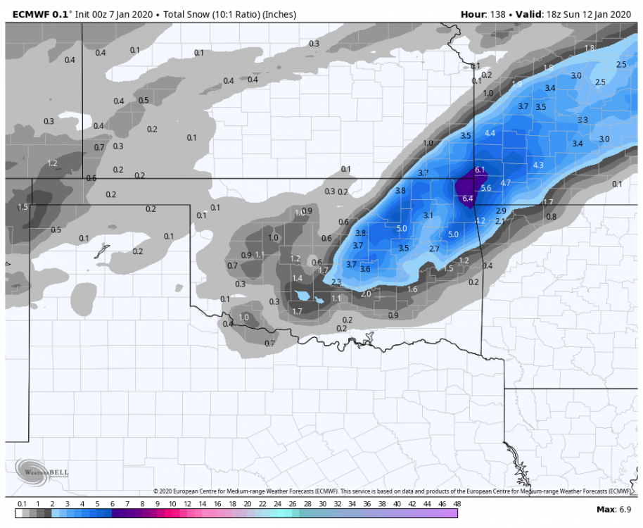
-
MO/KS/AR/OK 2019-2020 Winter Wonderland Discussion
StormChazer replied to JoMo's topic in Central/Western States
-
MO/KS/AR/OK 2019-2020 Winter Wonderland Discussion
StormChazer replied to JoMo's topic in Central/Western States
12Z GFS -
MO/KS/AR/OK 2019-2020 Winter Wonderland Discussion
StormChazer replied to JoMo's topic in Central/Western States
Yeah, the biggest difference I see when looking at the radar sim is the way the shield gets its act together, and trying to determine where exactly that deformation band sets up is tough to do until 1-2 days out. So far, 5 days out, I'm loving what I'm seeing..thumb.png.46e234acf0f95200a458e5bd5520bd36.png)
-
MO/KS/AR/OK 2019-2020 Winter Wonderland Discussion
StormChazer replied to JoMo's topic in Central/Western States
I know I know....I'm obsessing over the CANADIAN...but I need something to gush over until the Euro comes out in an hour. Decent Sleet.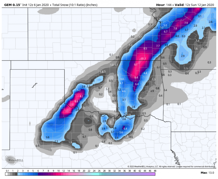
-
MO/KS/AR/OK 2019-2020 Winter Wonderland Discussion
StormChazer replied to JoMo's topic in Central/Western States
Can I just lock in the Canadian please?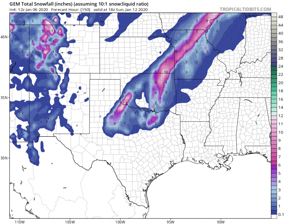
-
MO/KS/AR/OK 2019-2020 Winter Wonderland Discussion
StormChazer replied to JoMo's topic in Central/Western States
Latest in Tulsa... Stronger cold advection will occur Friday night into Saturday as the strong shortwave trough ejects into the southern Plains. The ECMWF and now the GFS indicate that a wrap-around band of precipitation will set up along a SW to NE deformation zone just to the north of the PV max track across northeast Oklahoma and northwest Arkansas. Quickly cooling thermal profiles would support a transition to sleet and snow by this time. The latest ECMWF shows several tenths of an inch of QPF in the band with thermal profiles cold enough for all snow during the day Saturday across our area, suggesting near warning criteria snow accums are possible. We are still several days out to focus too heavily on the details just yet, but chances are increasing that some impactful wintry weather is possible to start the weekend for some of us. -
MO/KS/AR/OK 2019-2020 Winter Wonderland Discussion
StormChazer replied to JoMo's topic in Central/Western States
*sweats in Tulsan* Euro
-
MO/KS/AR/OK 2019-2020 Winter Wonderland Discussion
StormChazer replied to JoMo's topic in Central/Western States
Canadian picking up on the deformation band in a big way.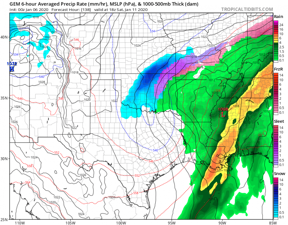
-
MO/KS/AR/OK 2019-2020 Winter Wonderland Discussion
StormChazer replied to JoMo's topic in Central/Western States
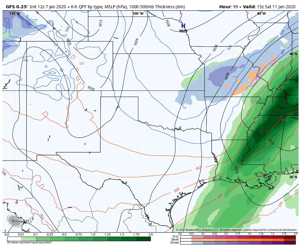
Tulsa is sticking with the Euro right now. By Saturday, the latest ECMWF solution tracks the ejecting upper low across SE OK and NW AR, with a NE to SW oriented wrap-around band of precip along the deformation zone extending from the Ozarks down across eastern OK to the northwest of the surface low track. Thermal profiles will cool enough by this time to favor a transition to snow in this band, so it is not out of the question that some impactful wintry weather could occur over our region by next weekend. -
MO/KS/AR/OK 2019-2020 Winter Wonderland Discussion
StormChazer replied to JoMo's topic in Central/Western States
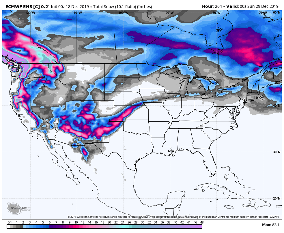
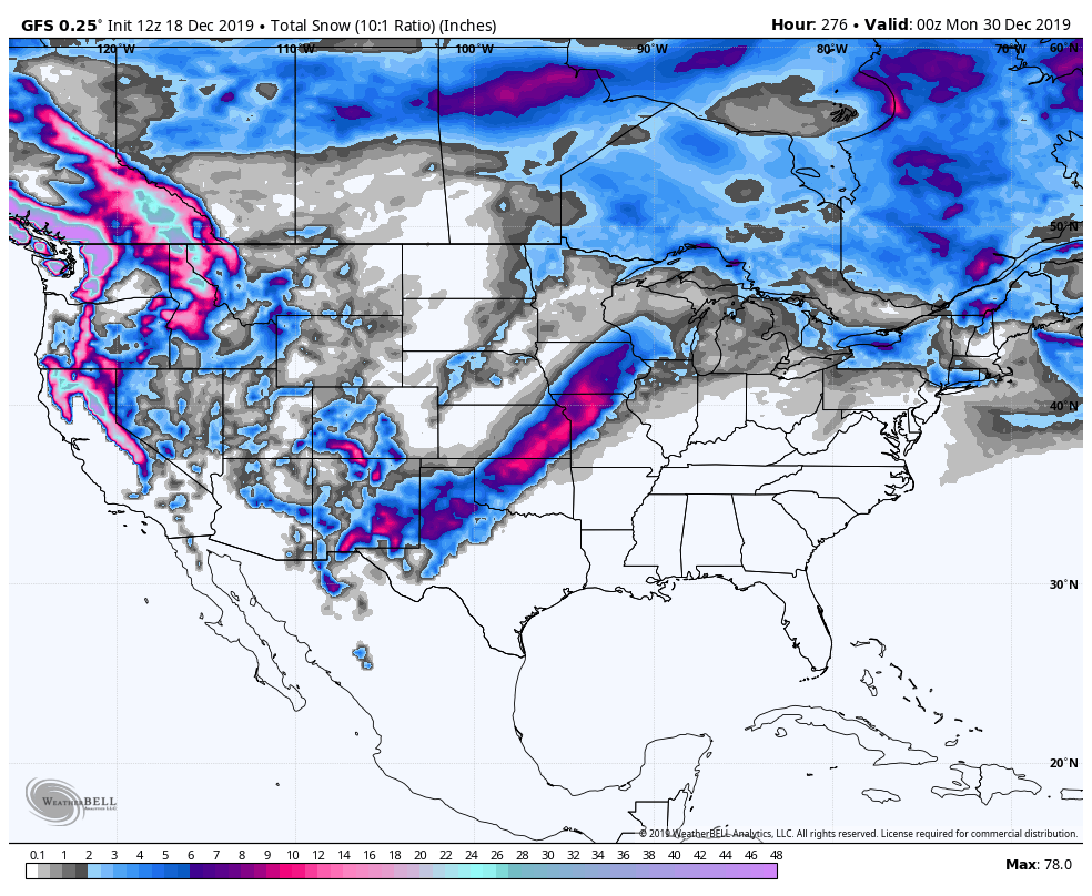
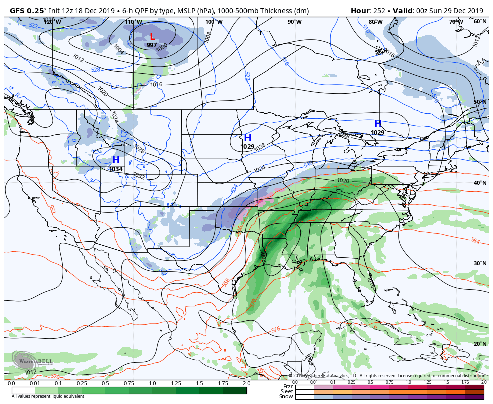
Hmmmm, tricky forecast for next weekend. Closed ULL on the Euro, which historically can drop some really high snowfall rates. GFS partially there as well. -
MO/KS/AR/OK 2019-2020 Winter Wonderland Discussion
StormChazer replied to JoMo's topic in Central/Western States
I've kept my mouth shut for a while, but GFS and Euro have both been picking up on something for mid Jan. -
MO/KS/AR/OK 2019-2020 Winter Wonderland Discussion
StormChazer replied to JoMo's topic in Central/Western States
I saw that! Definitely keeping my eye on it! 06Z picks up on that energy as well. -
MO/KS/AR/OK 2019-2020 Winter Wonderland Discussion
StormChazer replied to JoMo's topic in Central/Western States
Kansas City folks felt the same way we did after going a few seasons on a bad streak and last year they had 29.1 in of snow when they only average 18.8., and despite the warm Christmas, are currently above average on snowfall up to now. All I’m saying is it’ll get better. -
MO/KS/AR/OK 2019-2020 Winter Wonderland Discussion
StormChazer replied to JoMo's topic in Central/Western States
I don’t think I really buy into that theory. Also let me start by saying this is motivated ZERO by politics. If you look at the numbers, 2005-2010 was the 2nd snowiest stretch for Tulsa since accurate/reliable record keeping in the 1950’s. 2010-2015 was the 6th snowiest on record. And 2000-2005 was the 5th. I’d find it hard to believe we could go from those kinds of record breaking numbers to snow drought in just a matter of a few years if it were climate change related. I know amidst our frustration it’s easy to want to find a reason as to why this all is happening because having a solid reason makes us feel a little better and a little more in control. But the truth of the matter is, we’ve just been REALLY REALLY unlucky, the pattern hasn’t been super favorable and when it has, we’ve just BARELY been on the warm side of things. Most of Missouri the last few seasons has been getting above average snowfall. It’s just luck of the draw sometimes. Well go through more heavy snowfall periods in the future and look back at this stretch as being an anomaly. It’ll get better. It just stinks right now. -
MO/KS/AR/OK 2019-2020 Winter Wonderland Discussion
StormChazer replied to JoMo's topic in Central/Western States
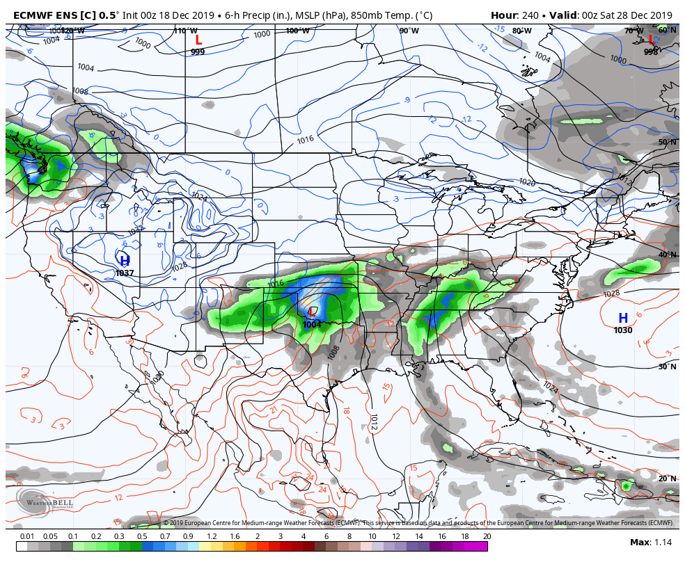
It's 10 days out, but we do have some long range consensus out of the GFS and Euro for the 28th-30th time frame.


-
MO/KS/AR/OK 2019-2020 Winter Wonderland Discussion
StormChazer replied to JoMo's topic in Central/Western States
I decided to go digging into the Tulsa NWS records for snowfall totals to see just how unprecedented our snow drought is. I took 5 year intervals of each season's(July of year X-June of year Y-which for us is really just Nov-March) total snowfall. Here are my findings. 1950/1951 - 1954/1955- 48.3 in 1955/1956 - 1959/1960- 64 in 1960/1961 - 1964/1965- 32.4 in 1965/1966 - 1969/1970- 60.6 in 1970/1971 - 1974/1975- 37.6 in 1975/1976 - 1979/1980- 48.2 in 1980/1981 - 1984/1985- 34 in 1985/1986 - 1989/1990- 57.6 in 1990/1991 - 1994/1995- 41.7 in 1995/1996 - 1999/2000- 37.2 in 2000/2001 - 2004/2005- 55.1 in 2005/2006 - 2009/2010- 61 in 2010/2011 - 2014/2015- 52.4 in 2015/2016 - 2019/2020- 8.8 in Before this most recent 5 year stretch we were averaging 48.47 inches of snow every 5 seasons. We are currently sitting at just 8.8 inches of total snow these past 5 seasons and would have to get 39.67 inches over the next 3 months to hit average. Our next closest 5 year low is back in the 1960's at 32.4 inches. Tulsa's average snowfall is 9.69 inches per season. Assuming we hit that, we will still blow the 1960-1965 seasons' low record stretch out of the water by a 13.91 inch deficit. Truly a Historic snow drought. -
MO/KS/AR/OK 2019-2020 Winter Wonderland Discussion
StormChazer replied to JoMo's topic in Central/Western States
Must be nice! haha...ha...*sobs*. -
MO/KS/AR/OK 2019-2020 Winter Wonderland Discussion
StormChazer replied to JoMo's topic in Central/Western States
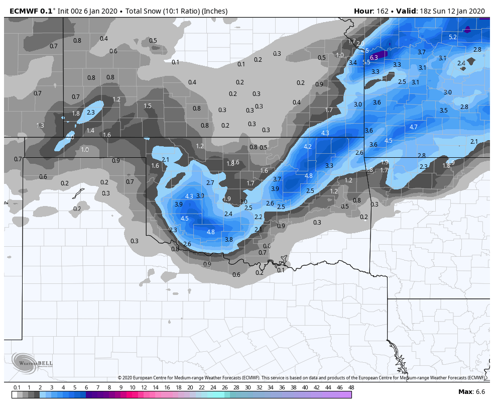
Question for the vets out there. Is there a place that shows every model run of say the GFS or Euro that has ever come out? Or back 10-20 years, etc? Like, if I was wanting to find a particular prolific winter storm from my past and was curious what the models showed leading up to it at the time, is there anywhere I can access that?
.png.d78d14969427bd688182278161df3204.png)
.png.2982d7eb67416fe585af4bae6605f55a.png)
.png.1b4485a300387153245dff578aa4f0e9.png)

.png.3e4bef0c7edf731659ea3466421b31ca.png)