StormChazer
-
Posts
1,231 -
Joined
-
Last visited
Content Type
Profiles
Blogs
Forums
American Weather
Media Demo
Store
Gallery
Everything posted by StormChazer
-

MO/KS/AR/OK 2019-2020 Winter Wonderland Discussion
StormChazer replied to JoMo's topic in Central/Western States
I will not get excited about next weekend. I will not get excited about next weekend. I will NOT get excited about next weekend. -
MO/KS/AR/OK 2019-2020 Winter Wonderland Discussion
StormChazer replied to JoMo's topic in Central/Western States
Watching that March 2nd-4th time frame....I can’t help it. Every time I get burned, I say, “that’s it, I’m done for the season” but I can’t stop myself. Now I understand why people don’t leave abusive relationships...I get it, lol. -
MO/KS/AR/OK 2019-2020 Winter Wonderland Discussion
StormChazer replied to JoMo's topic in Central/Western States
My new rule for the rest of this "winter" is unless we are issued a winter storm warning, I'm not going to speak of it.....ok,..unless the models are in 100% agreement for a monster, I'll talk about it then, lol. -
MO/KS/AR/OK 2019-2020 Winter Wonderland Discussion
StormChazer replied to JoMo's topic in Central/Western States
If anyone was wondering who got it good yesterday.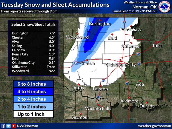
-
MO/KS/AR/OK 2019-2020 Winter Wonderland Discussion
StormChazer replied to JoMo's topic in Central/Western States
Interesting. If that’s the thermal profile of the atmosphere now with light precipitation, I’d think that means when the heavier stuff moves in and drags the colder air down that we’d see all sleet and snow coming down moderately to heavy. -
MO/KS/AR/OK 2019-2020 Winter Wonderland Discussion
StormChazer replied to JoMo's topic in Central/Western States
Lightest bit of rain, sleet and snow all simultaneously fell in south Tulsa. As I type it’s straight sleet now. If it’s like this now, curious if that means sleet later when it picks up. -
MO/KS/AR/OK 2019-2020 Winter Wonderland Discussion
StormChazer replied to JoMo's topic in Central/Western States
It'll be good to watch those temps down there to see if they start dropping. -
MO/KS/AR/OK 2019-2020 Winter Wonderland Discussion
StormChazer replied to JoMo's topic in Central/Western States
I'll be honest here. Tulsa NWS is doing the best they can, but I think they've conceded to the fact that this is nowcasting at this point. We truly just won't know until the precip arrives. It's hard to predict if it will rain hard enough to pull the colder air down and cool the column enough to counteract how warm it gets beforehand. I mean......how does one calculate the needed rate of rainfall necessary to counteract each degree? If it's 1 degree warmer than predicted, how much heavier does the precip need to be to cancel that out, etc? Kudos to TSA(and Norman) as this stuff is just a mess to predict. But until it starts falling and we see where that transition line is setting up, it's just all about using climatological norms, and and weather balloons/models to try and predict this, which in the 11th hour, is a crapshoot in this kind of set up(imo). -
MO/KS/AR/OK 2019-2020 Winter Wonderland Discussion
StormChazer replied to JoMo's topic in Central/Western States
It's oddly therapeutic for me to do this. Here is the 12Z 3K NAM. I outlined the 2 inch contour and highlighted Tulsa county. If this verified this way, I would rage. What is it about this area? It feels supernatural at this point! lol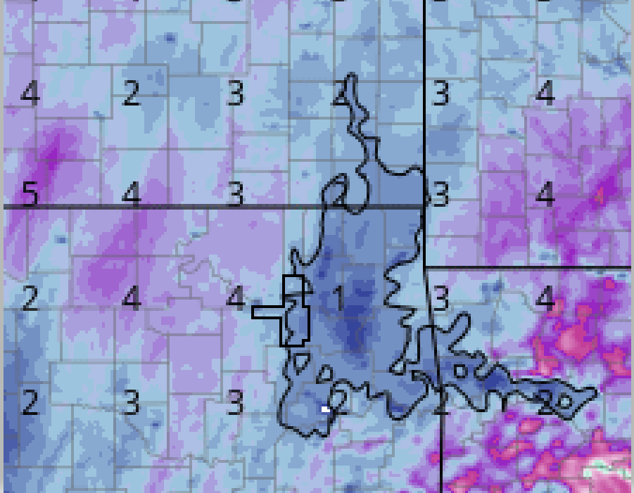
-
MO/KS/AR/OK 2019-2020 Winter Wonderland Discussion
StormChazer replied to JoMo's topic in Central/Western States
Models do seem to be going cooler tonight. Tulsa Mets/news still not impressed at all. Wonder if this will catch ppl off guard. -
MO/KS/AR/OK 2019-2020 Winter Wonderland Discussion
StormChazer replied to JoMo's topic in Central/Western States
Local met Mike Collier in Tulsa not even remotely biting on this thing.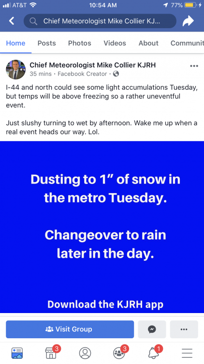
-
MO/KS/AR/OK 2019-2020 Winter Wonderland Discussion
StormChazer replied to JoMo's topic in Central/Western States
12Z Canadian FWIW.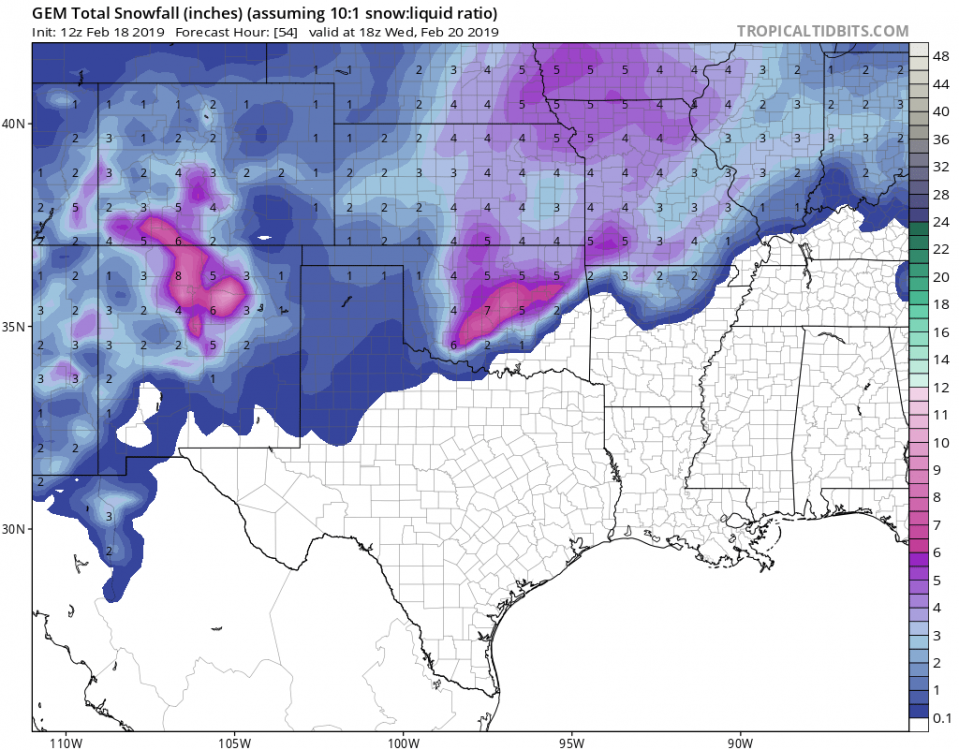
-
MO/KS/AR/OK 2019-2020 Winter Wonderland Discussion
StormChazer replied to JoMo's topic in Central/Western States
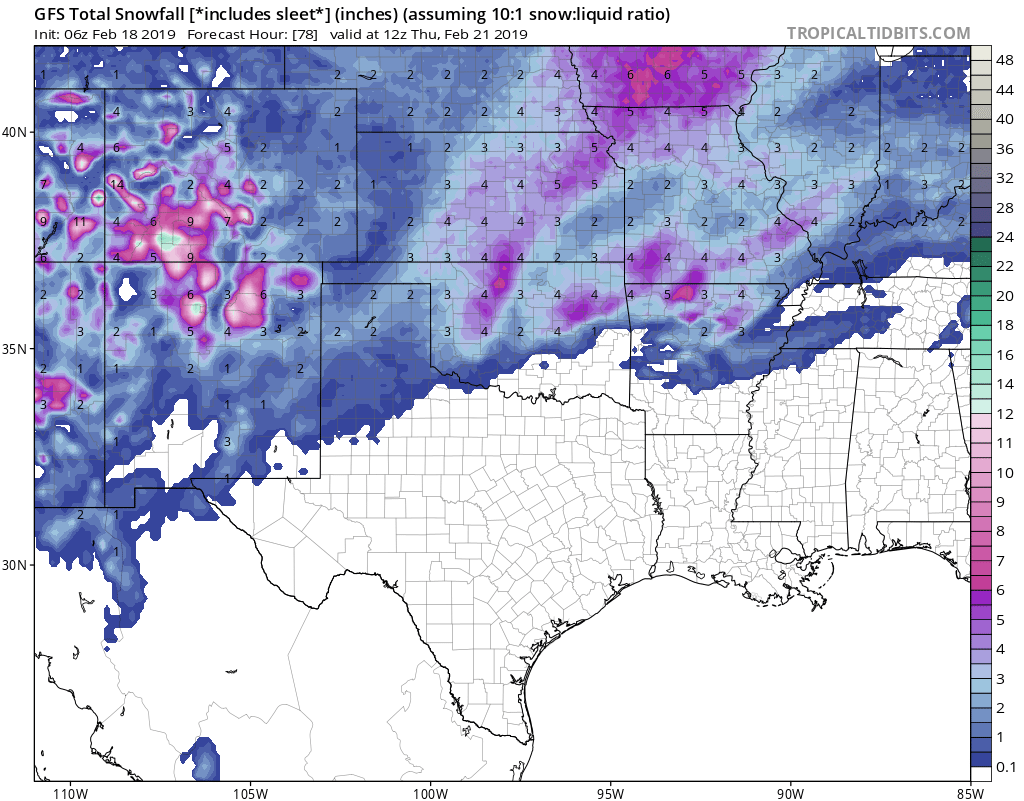
Beat me to the punch on the GFS! For better or worse, I'm definitely not hearing much about this storm from local news outlets, and we're 24 hours out. I feel like this has the potential to drop 2-3 inches of snow/sleet in the Tulsa metro. But there's a BIG difference between 2 inches of snow and 2 inches of sleet. -
MO/KS/AR/OK 2019-2020 Winter Wonderland Discussion
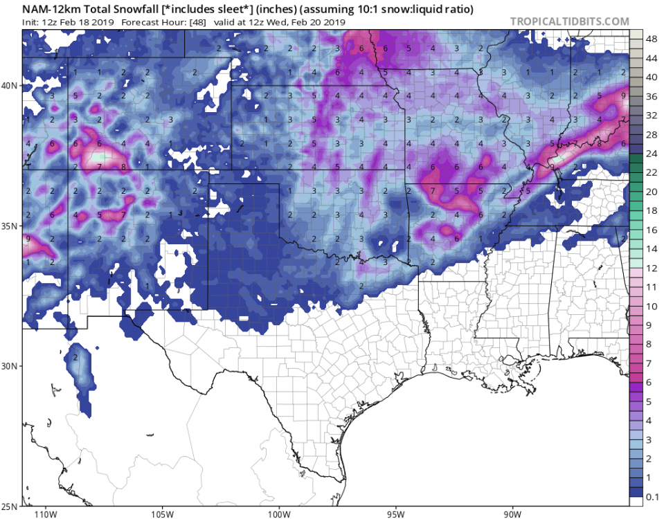
StormChazer replied to JoMo's topic in Central/Western States
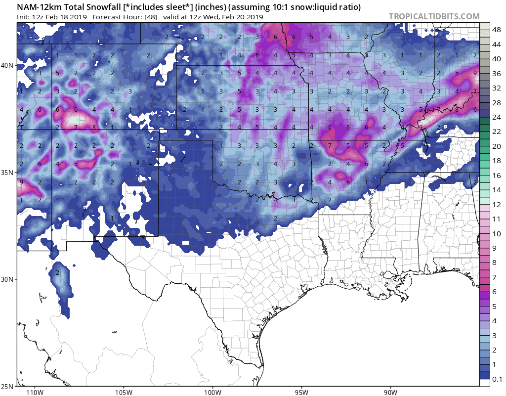
When I saw that map I just laughed...what a cluster....lol. Like I said earlier, 1/2 inch of sleet is more than enough to turn the roads into havoc; I'm especially worried about the evening rush hour in the Tulsa metro. Here is the 06Z GFS, still aligning with last night's 0Z GFS and then here is the 12Z NAM. Definitely some agreement in these two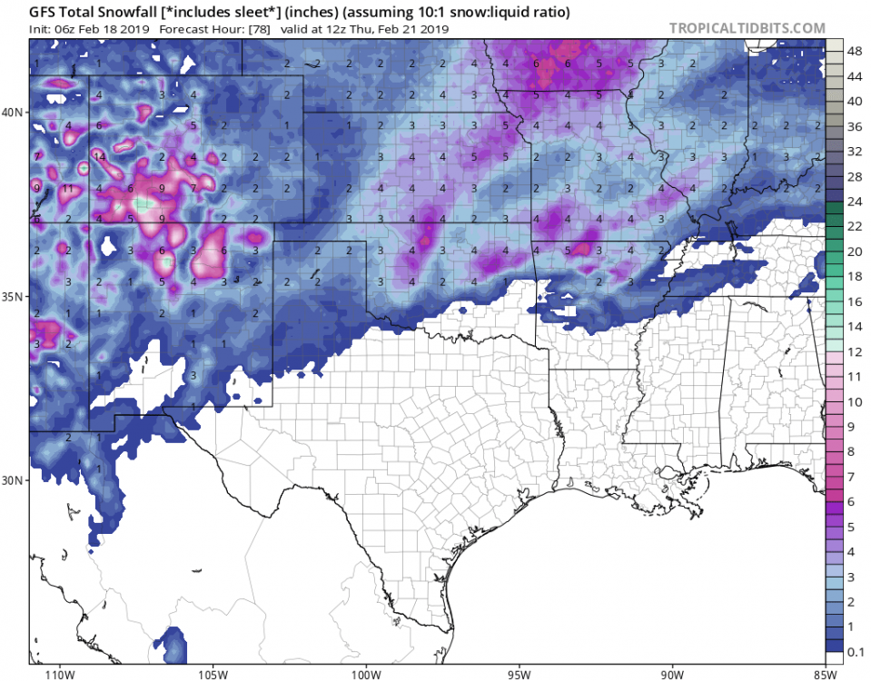
-
MO/KS/AR/OK 2019-2020 Winter Wonderland Discussion
StormChazer replied to JoMo's topic in Central/Western States
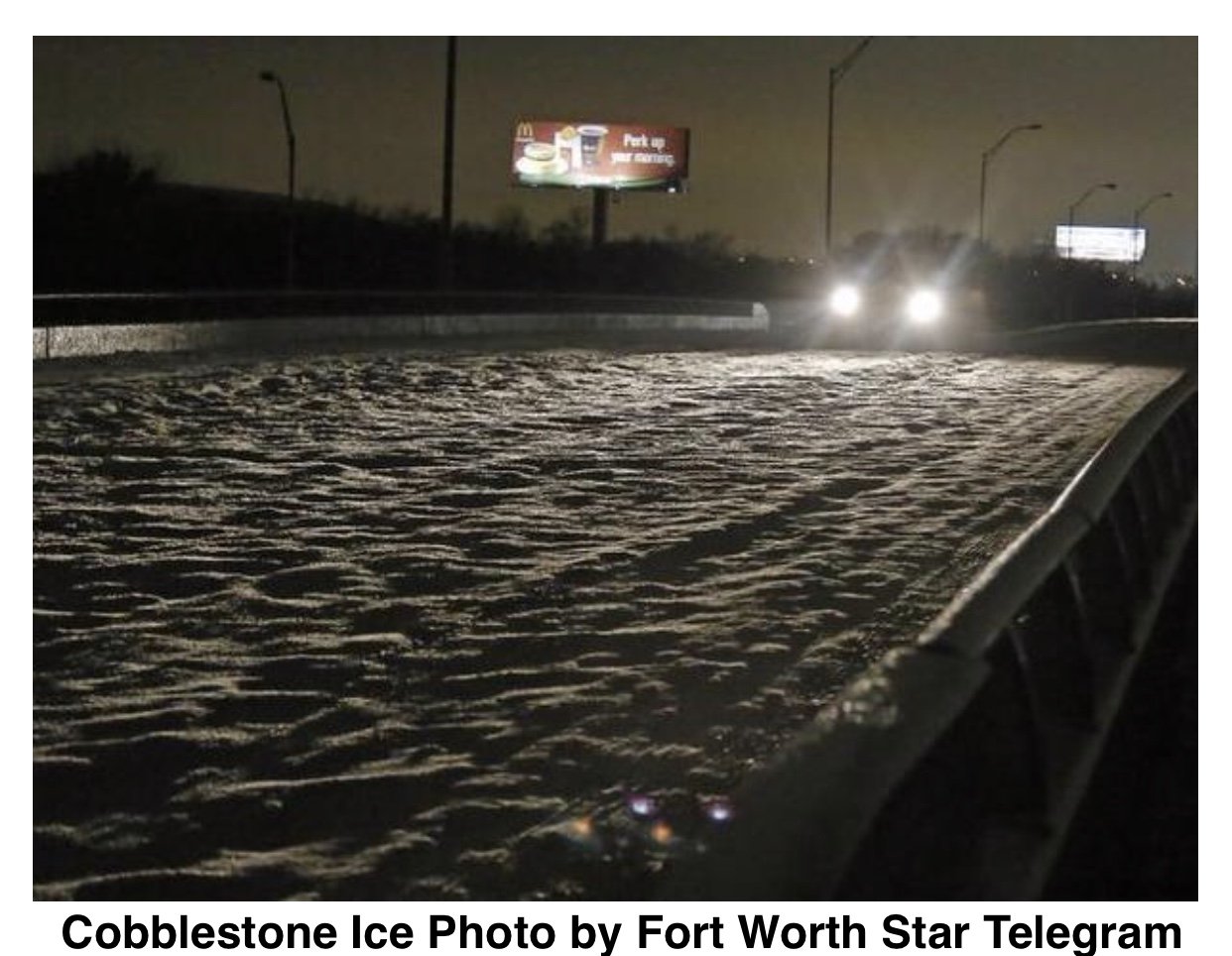
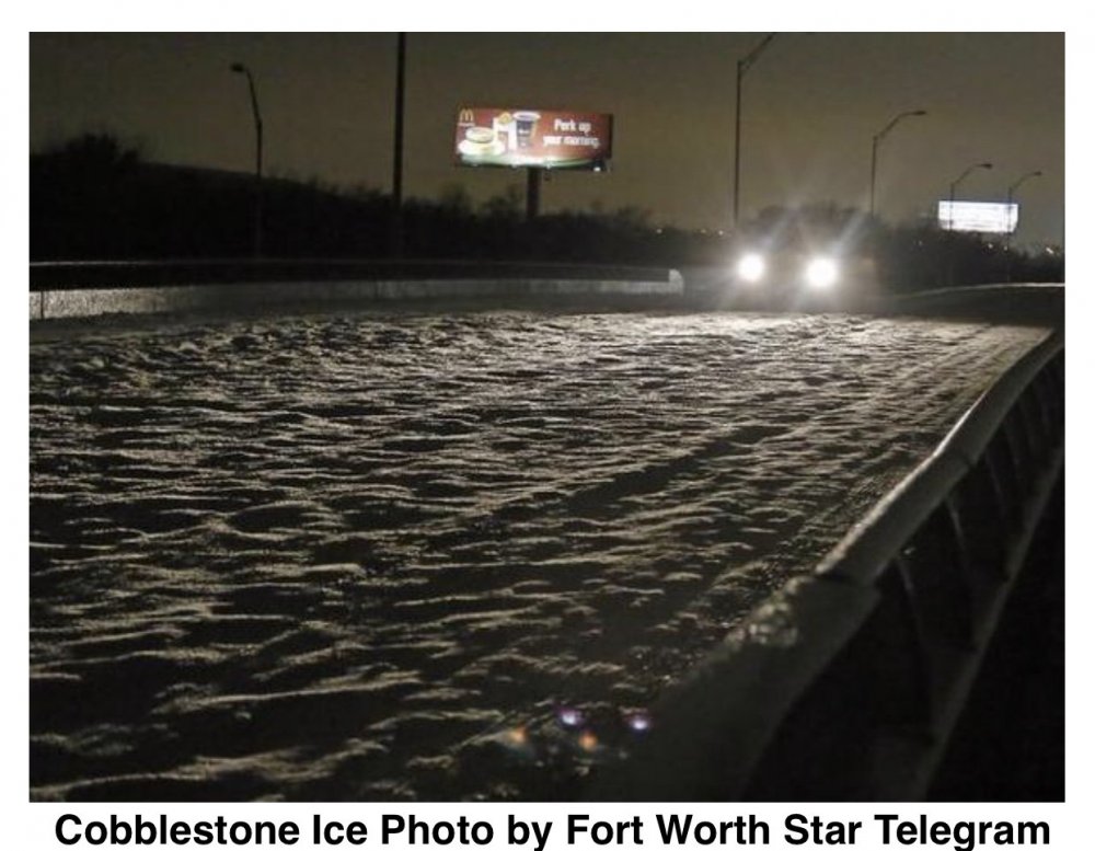
A follow up to that last post. That picture of the road is just hard, slick ice with ZERO give. A week to remember!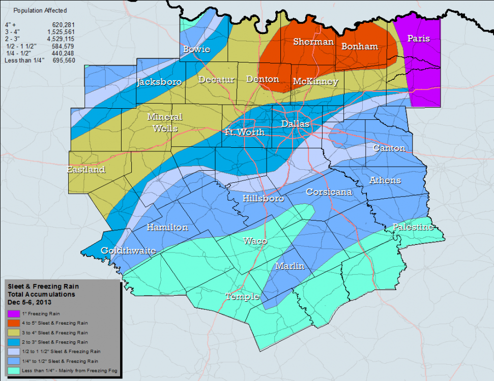
-
MO/KS/AR/OK 2019-2020 Winter Wonderland Discussion
StormChazer replied to JoMo's topic in Central/Western States
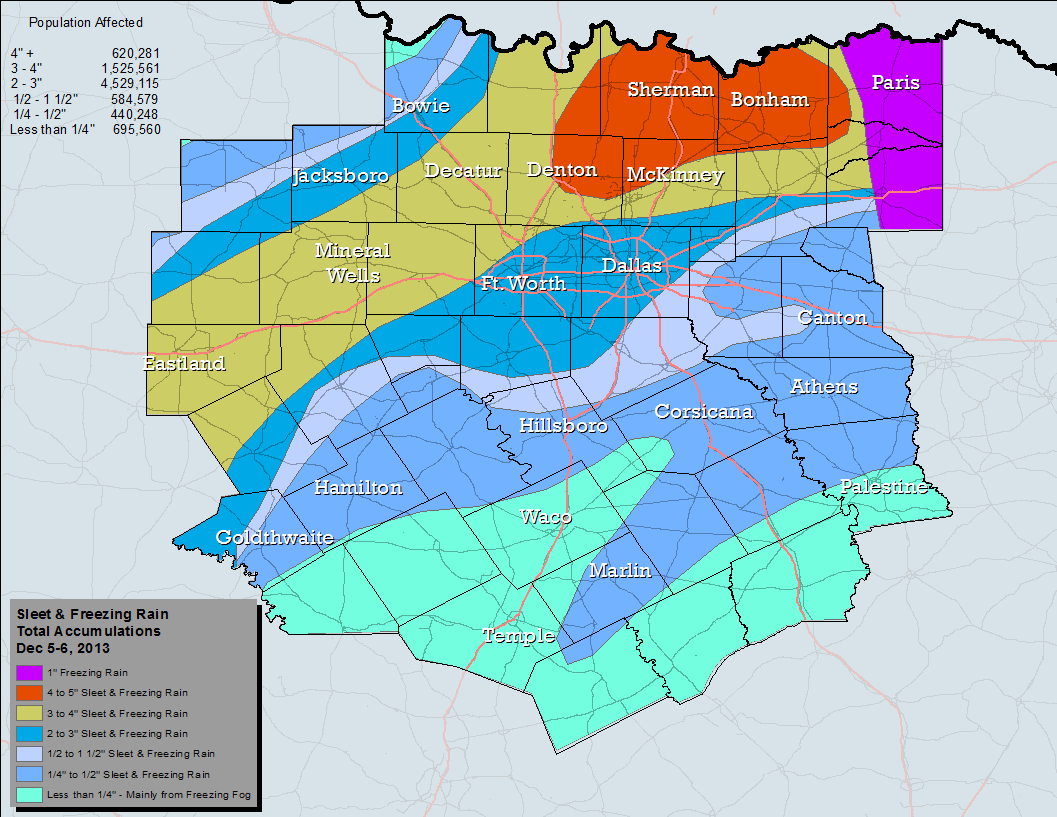
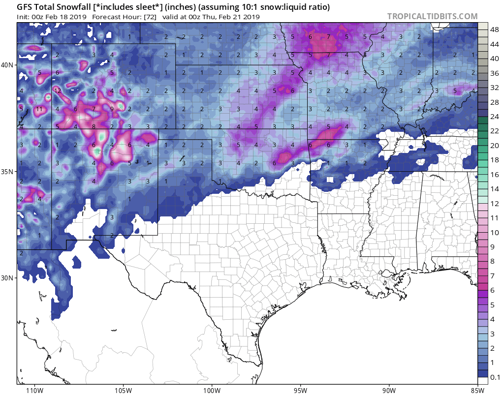
The latest gfs bringing the heat on snow/sleet just south of Tulsa. The heavier precipitation is in eastern OK/western AR, if the cold air is stubborn enough and doesn’t recede(as these shallow systems tend to be resistant to the warm air winning out like the models depict) then I think there’s a real possibility of a small swath of moderate snow or sleet combo in said area. I’m concerned on how much of this falls as sleet. I need to check the soundings. Several years ago when I lived in Dallas(Denton to be exact) we got FIVE inches of sleet....it shut the city down for about 4 days straight because the sheer amount of ice on the roadways was insane. They called it the cobblestone ice event. When cars would travel on the thick sleet that first day, it carved out inconsistent tracks in the road, and then it refroze each night to this extremely pot hole, bumpy, slick, HARD sheet of ice that made driving literally impossible. Crazy times. All that to say, is half an inch of sleet is enough to turn the roads into an ice skating rink, so I’m curious to see if that’s going to pose a threat in this or not.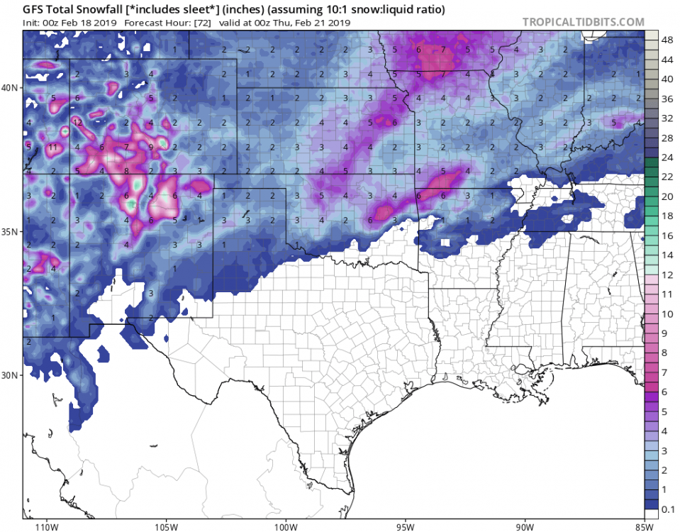
-
MO/KS/AR/OK 2019-2020 Winter Wonderland Discussion
StormChazer replied to JoMo's topic in Central/Western States
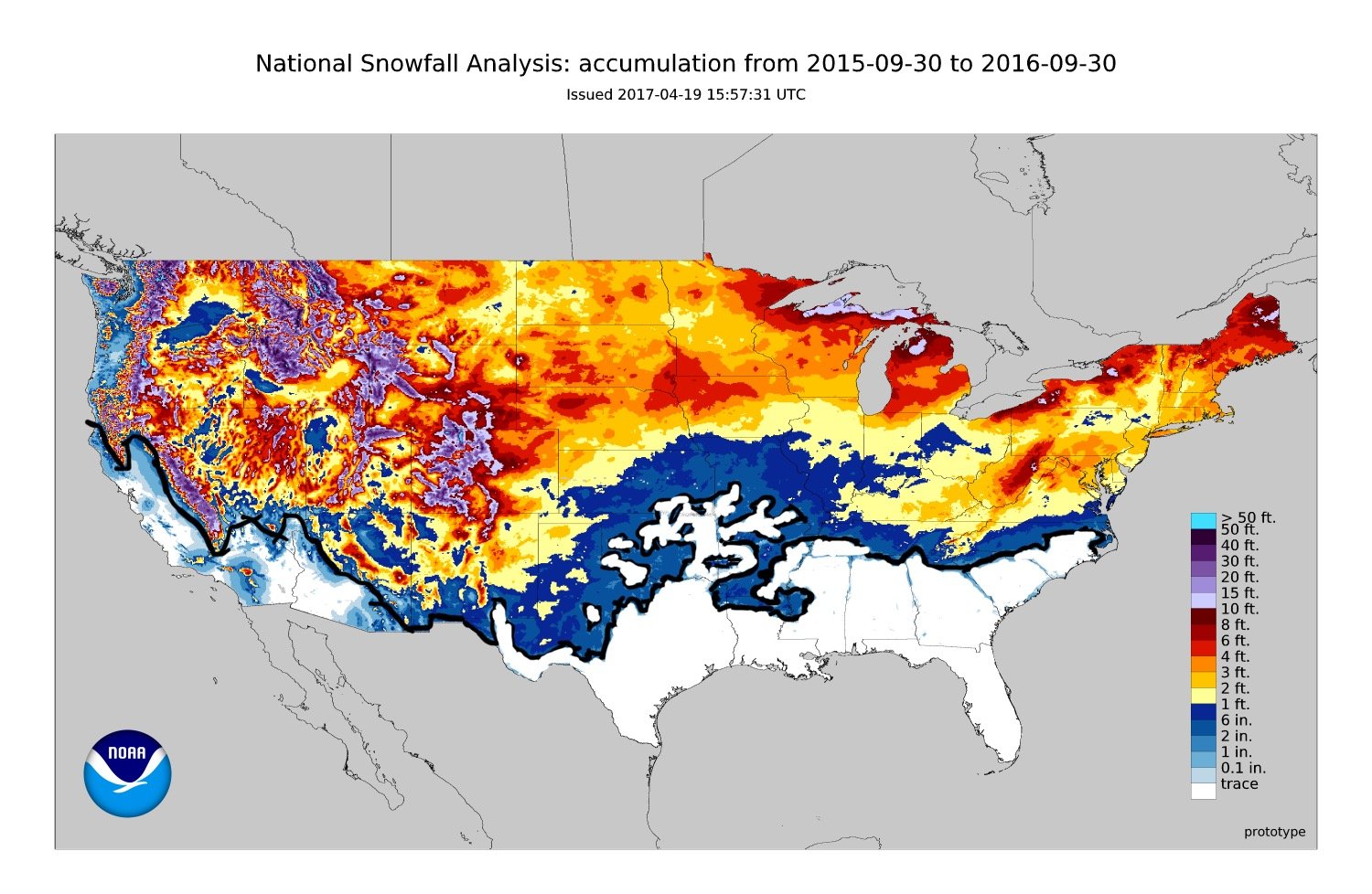
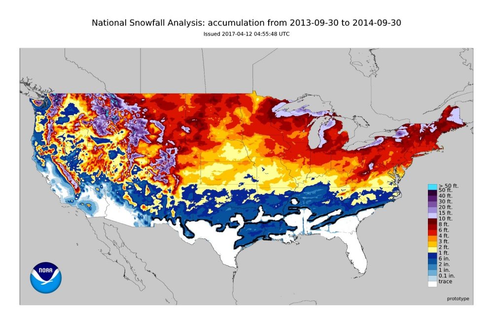
Last ones I promise!! These two are from 2013-2014 and 2014-2015. Fun fact, I moved to Tulsa I’m the spring of 2015, so all I’ve known since I’ve moved here is a snowless land...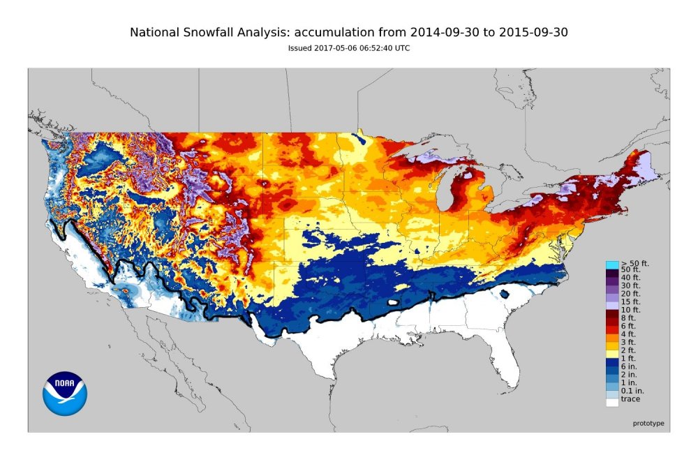
-
MO/KS/AR/OK 2019-2020 Winter Wonderland Discussion
StormChazer replied to JoMo's topic in Central/Western States
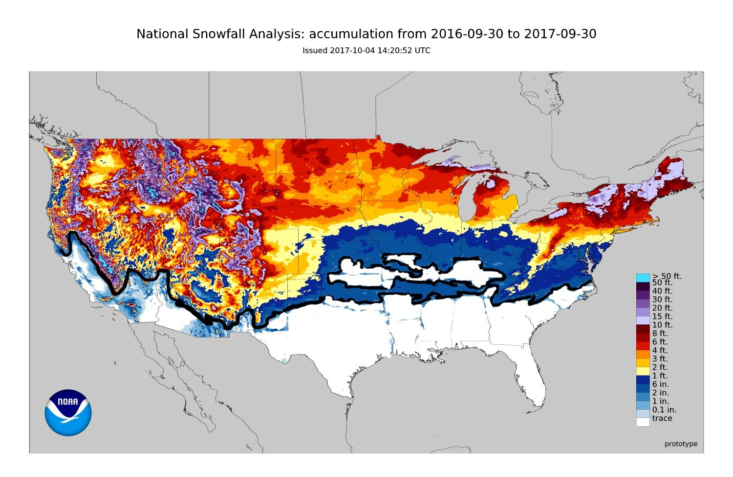
Thanks for the compliments! Here’s one more map of the 15-16 season.
-
MO/KS/AR/OK 2019-2020 Winter Wonderland Discussion
StormChazer replied to JoMo's topic in Central/Western States
Last two winters for your viewing pleasure....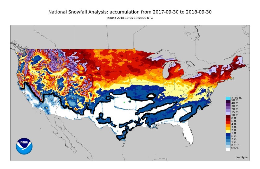

-
MO/KS/AR/OK 2019-2020 Winter Wonderland Discussion
StormChazer replied to JoMo's topic in Central/Western States
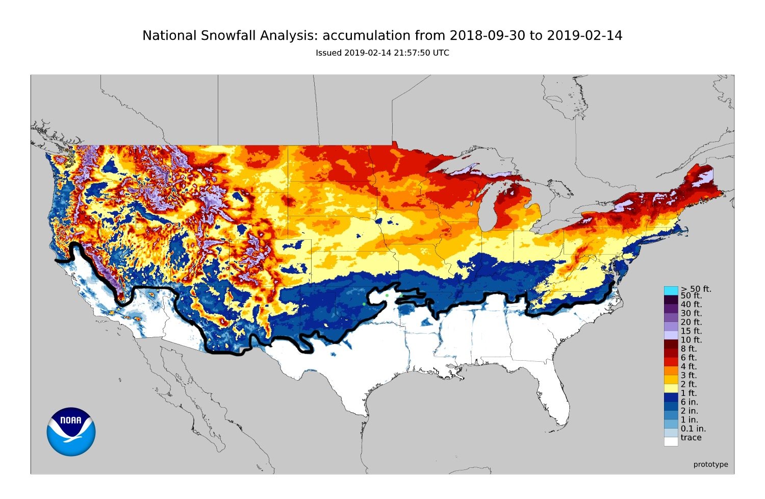
Because I’m a masochist, here is the seasonal snowfall total as of today. I took the liberty of crudely editing it on my phone to erase any amounts of less than 2 inches of snow and added a black border. Really shows that snow hole. I marked OKC, Tulsa and Fayetteville with green dots.
-
MO/KS/AR/OK 2019-2020 Winter Wonderland Discussion
StormChazer replied to JoMo's topic in Central/Western States
I know it’s easy to feel that way, but look at Kansas City, they were in the same boat as us and then this year has finally broke their curse. It’ll happen but this won’t last forever. -
MO/KS/AR/OK 2019-2020 Winter Wonderland Discussion
StormChazer replied to JoMo's topic in Central/Western States
I wouldn’t pay too terribly much to the long range nam. Give it until Monday morning. -
MO/KS/AR/OK 2019-2020 Winter Wonderland Discussion
StormChazer replied to JoMo's topic in Central/Western States
These models are making me really nervous. Every single one has Tulsa RIGHT on the line. I know models don’t handle shallow air well, so my hope is that they’re underdoing it right now but I swear if it’s 33-34 and raining on Tuesday while 30 miles west it’s snowing I’m going to officially admit that the snow gods hate NE OK. That being said, if they are underdoing the cold air, then that honestly sets Tulsa up for an ice storm, which to be honest, at this point, my winter weather starved self would welcome. -
MO/KS/AR/OK 2019-2020 Winter Wonderland Discussion
StormChazer replied to JoMo's topic in Central/Western States
Latest GFS looking similar to Euro -
MO/KS/AR/OK 2019-2020 Winter Wonderland Discussion
StormChazer replied to JoMo's topic in Central/Western States
Yeah, I must say this is the last storm of the season that I'm going to follow or feel any excitement leading up to it. If this churns out nothing for us, then unless something is a day out I'm going to need to recharge until next winter. That being said, here's the EURO. Interestingly enough, it keep Tulsa JUST BARELY above freezing for a few hours during moderate precip, so if that snow line inches over 30 miles, Tulsa looks to get 4-6 inches. I know amounts are trivial and useless to get focused on this far out, but just worth noting.