StormChazer
-
Posts
1,231 -
Joined
-
Last visited
Content Type
Profiles
Blogs
Forums
American Weather
Media Demo
Store
Gallery
Everything posted by StormChazer
-

MO/KS/AR/OK 2019-2020 Winter Wonderland Discussion
StormChazer replied to JoMo's topic in Central/Western States
I would legitimately pay a large sum of money to be having what STL is having today.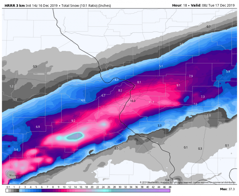
-
MO/KS/AR/OK 2019-2020 Winter Wonderland Discussion
StormChazer replied to JoMo's topic in Central/Western States
Smh! I give up and suddenly boom, ice lol. ive got family in St.Louis and am beyond jealous. Wrecks starting to pile up here in Tulsa. -
MO/KS/AR/OK 2019-2020 Winter Wonderland Discussion
StormChazer replied to JoMo's topic in Central/Western States
I think it's time for me to retreat into my hermit-like state until the next system catches my attention. Then I'll go back to obsessing. -
MO/KS/AR/OK 2019-2020 Winter Wonderland Discussion
StormChazer replied to JoMo's topic in Central/Western States
I should specify that the in between runs only go out 90 hours and up to hour 90, the snowfall was actually going more south before the run ends, it’s only with the control run that you can look further that shows the snow, but it’s the control, not the OP. Members do show some runs going more north but virtually the same amount of heavier snows in our area. -
MO/KS/AR/OK 2019-2020 Winter Wonderland Discussion
StormChazer replied to JoMo's topic in Central/Western States
I can confirm the 18Z euro went slightly north, but I would take that worth a grain of salt and wait for the 00Z Euro. -
MO/KS/AR/OK 2019-2020 Winter Wonderland Discussion
StormChazer replied to JoMo's topic in Central/Western States
If you're in the camp of "throw out the 06Z and 18Z runs" because they use old upper air data but new surface data, then those two runs provide the more northern solution, whereas the 12Z with the most complete data shows a more southern track. If the 00Z GFS tonight goes south again like the 12Z did, then I'll be inclined to believe the more consistent Euro knows what is going on. -
MO/KS/AR/OK 2019-2020 Winter Wonderland Discussion
StormChazer replied to JoMo's topic in Central/Western States
I'll post all the members with my analysis once they're done resolving. -
MO/KS/AR/OK 2019-2020 Winter Wonderland Discussion
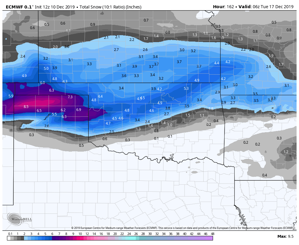
StormChazer replied to JoMo's topic in Central/Western States
Here you are everyone. Euro totals for 12Z run. Not near as heavy(but Euro tends to reduce as events get closer), and a hair south.
.thumb.png.43f39495e4ba19ec7da9565df2f03482.png)
-
MO/KS/AR/OK 2019-2020 Winter Wonderland Discussion
StormChazer replied to JoMo's topic in Central/Western States
Hour 129 Diff.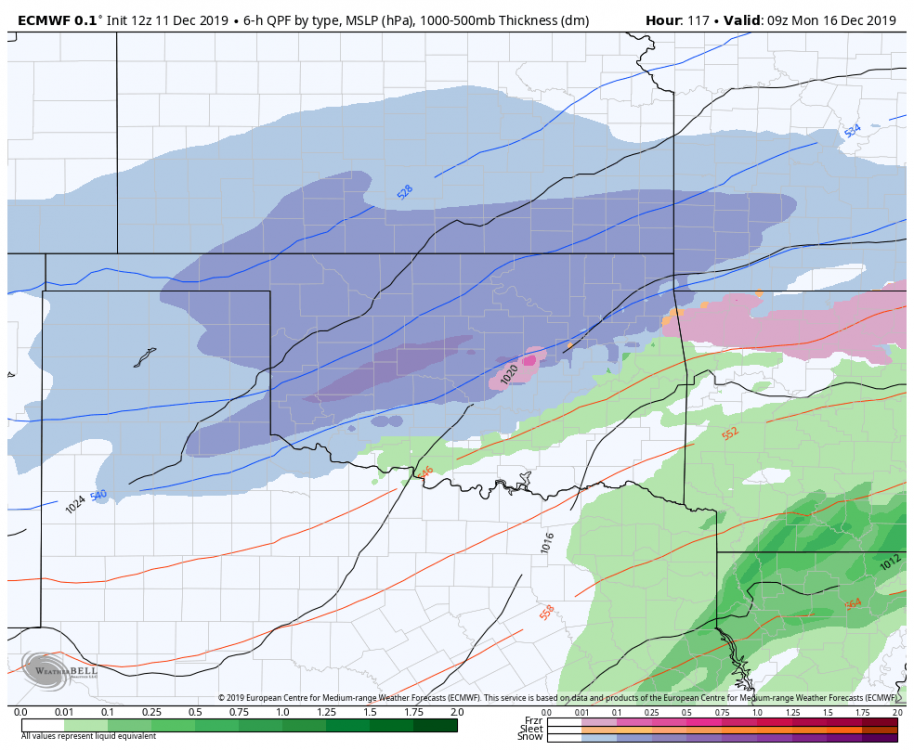
.thumb.png.f27b51b3d0d2ea8610c7fd3fc683e93f.png)
-
MO/KS/AR/OK 2019-2020 Winter Wonderland Discussion
StormChazer replied to JoMo's topic in Central/Western States
This run is looking more south but weaker, colder air pushing further south as well. -
MO/KS/AR/OK 2019-2020 Winter Wonderland Discussion
StormChazer replied to JoMo's topic in Central/Western States
Hour 111 difference.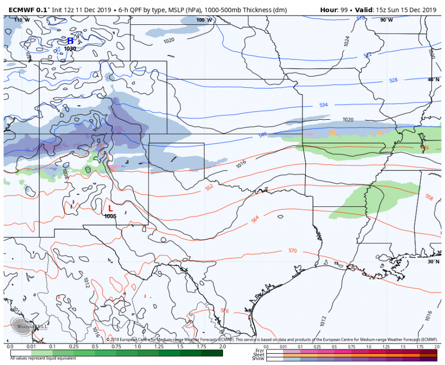
.thumb.png.2164d56457c75922162b2cc9c537b244.png)
-
MO/KS/AR/OK 2019-2020 Winter Wonderland Discussion
StormChazer replied to JoMo's topic in Central/Western States
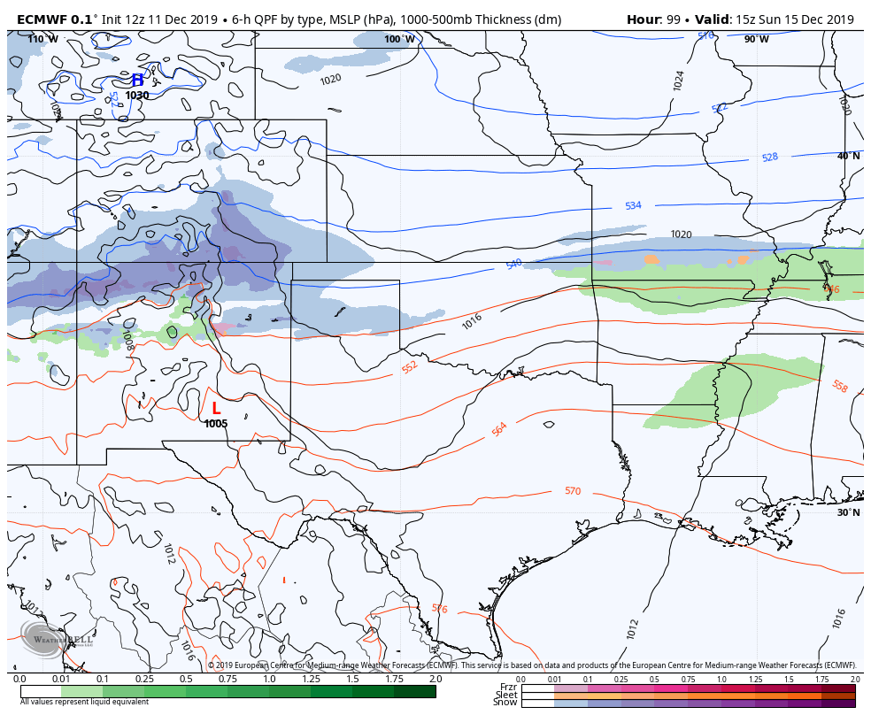
Noticing some changes in hour 102 in the euro, waiting to see what happens. -
MO/KS/AR/OK 2019-2020 Winter Wonderland Discussion
StormChazer replied to JoMo's topic in Central/Western States
.thumb.png.6ca265e001fdcf32ad40a718fffba95f.png)
.thumb.png.9f3a4c9f48a6f7b0240bd12b04e5d19a.png)
-
MO/KS/AR/OK 2019-2020 Winter Wonderland Discussion
StormChazer replied to JoMo's topic in Central/Western States
I don't think so. i can post the members on here if you'd like. -
MO/KS/AR/OK 2019-2020 Winter Wonderland Discussion
StormChazer replied to JoMo's topic in Central/Western States
OK, here are the latest 5 Euro runs. I analyzed the snowfall amounts in a 100 mile radius of Tulsa. Here are my results. Looking for trends here. Number of members from each run are indicated below. 0 Inches. 18,8,6,3,2 Summary: looks more and more likely that a "no snow" option is out the door. Under 1 inch. 8,14,15,20,19 Summary: Better than nothing, but an underwhelming category. Goes up over recent runs, mainly converting "no snow" options to minimal snow(so still positive). 1-3 inches. 10,14,12,14,11 Summary: This is a broad category that I'll refine in future analysis, some of these are 1 inch across half the area, others are a solid 2 inches across everywhere. Regardless, this option remains pretty steady consisting of about 20%-25% of the members. 3+ inches, 14,14,17,13,18 Summary: Some of these are BOMBS, some are just a respectable swath of 3-4 inches, some give half the area a winter storm while leaving the other half out high and dry. Point is, this category has remained pretty steady throughout the last couple days. Last night's run brought it down to a low, but then the 6Z brought it up to a high(don't know if we can trust the 6z). If the 12Z this afternoon brings this category back to last night's, then we can throw out the 6Z. So it looks like someone within 100 mile radius of Tulsa is pretty much guaranteed to get snow, could be a trace, could be a good dumping. Time to wait for the 12Z Euro. -
MO/KS/AR/OK 2019-2020 Winter Wonderland Discussion
StormChazer replied to JoMo's topic in Central/Western States
Yeah, inched south a decent amount, more towards the euro as opposed to the other way around. We'll see what the 12Z Euro shows. FWIW the 06Z euro members upped our snow chances from the 00Z Euro. -
MO/KS/AR/OK 2019-2020 Winter Wonderland Discussion
StormChazer replied to JoMo's topic in Central/Western States
Anyone know if the 06Z and 18Z runs of the Euro are ever worth looking at? Because the 06Z runs on the Euro push the snow a touch south of last night's run which would benefit most all of us. -
MO/KS/AR/OK 2019-2020 Winter Wonderland Discussion
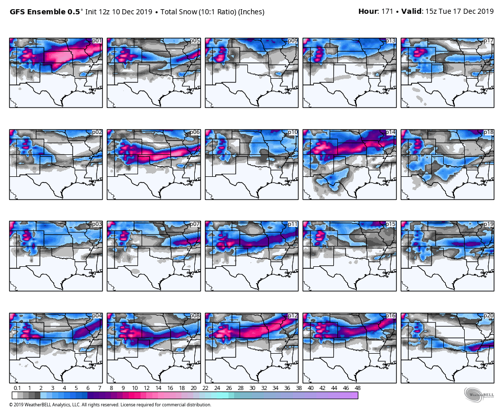
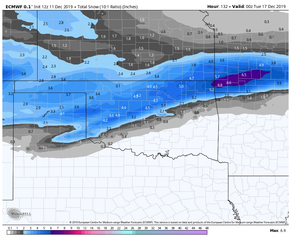
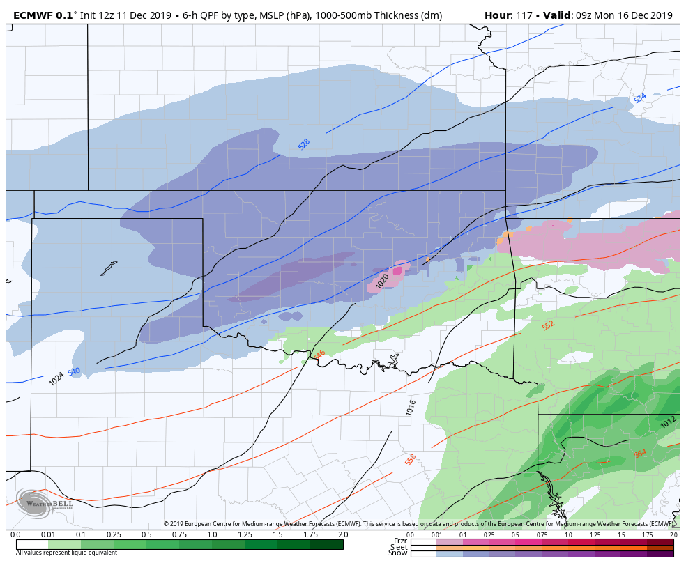
StormChazer replied to JoMo's topic in Central/Western States
Took it out to the 17th so as not to be influenced by the monster afterwards.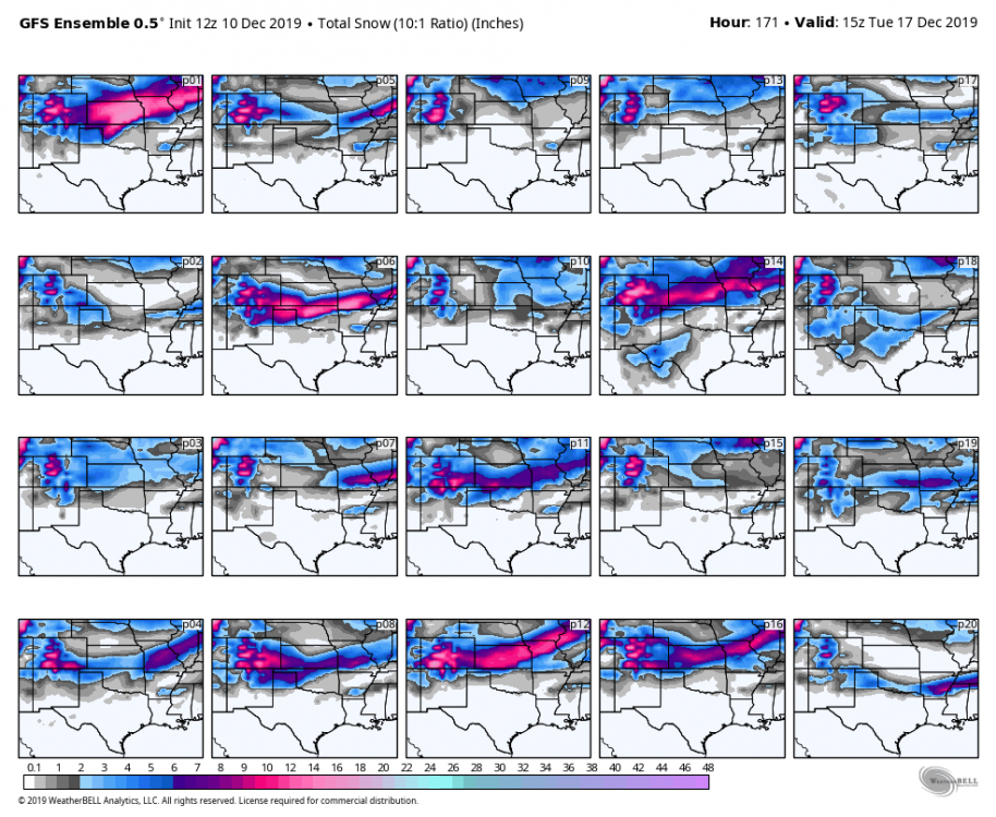
-
MO/KS/AR/OK 2019-2020 Winter Wonderland Discussion
StormChazer replied to JoMo's topic in Central/Western States
So initial thoughts, the GFS backs off the first round of precip on Sun night, but the 2nd round is still in play, and technically comes a touch closer to Northern OK than the 12Z run, it's also looking at this point that the big winter storm on the 12Z run is still in play, but it hasn't gone that far yet. -
MO/KS/AR/OK 2019-2020 Winter Wonderland Discussion
StormChazer replied to JoMo's topic in Central/Western States
I'll post the 12Z ensembles shortly. Not sure if there's any free public options. -
MO/KS/AR/OK 2019-2020 Winter Wonderland Discussion
StormChazer replied to JoMo's topic in Central/Western States
Yeah, it looks like about a 60 mile wide band of the heaviest snow, outside of that, respectable to the north, quick decline south. A run I'd be more than happy with resolving.
-
MO/KS/AR/OK 2019-2020 Winter Wonderland Discussion
StormChazer replied to JoMo's topic in Central/Western States
Main precip shield is looking further south but not quite as strong as of hour 126. Edit: looking like more lagging juice with this run though, so might see similar totals. -
MO/KS/AR/OK 2019-2020 Winter Wonderland Discussion
StormChazer replied to JoMo's topic in Central/Western States
I think the Euro is sticking to it's guns. -
MO/KS/AR/OK 2019-2020 Winter Wonderland Discussion
StormChazer replied to JoMo's topic in Central/Western States
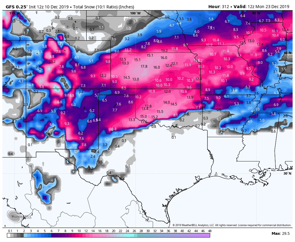
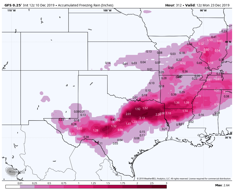
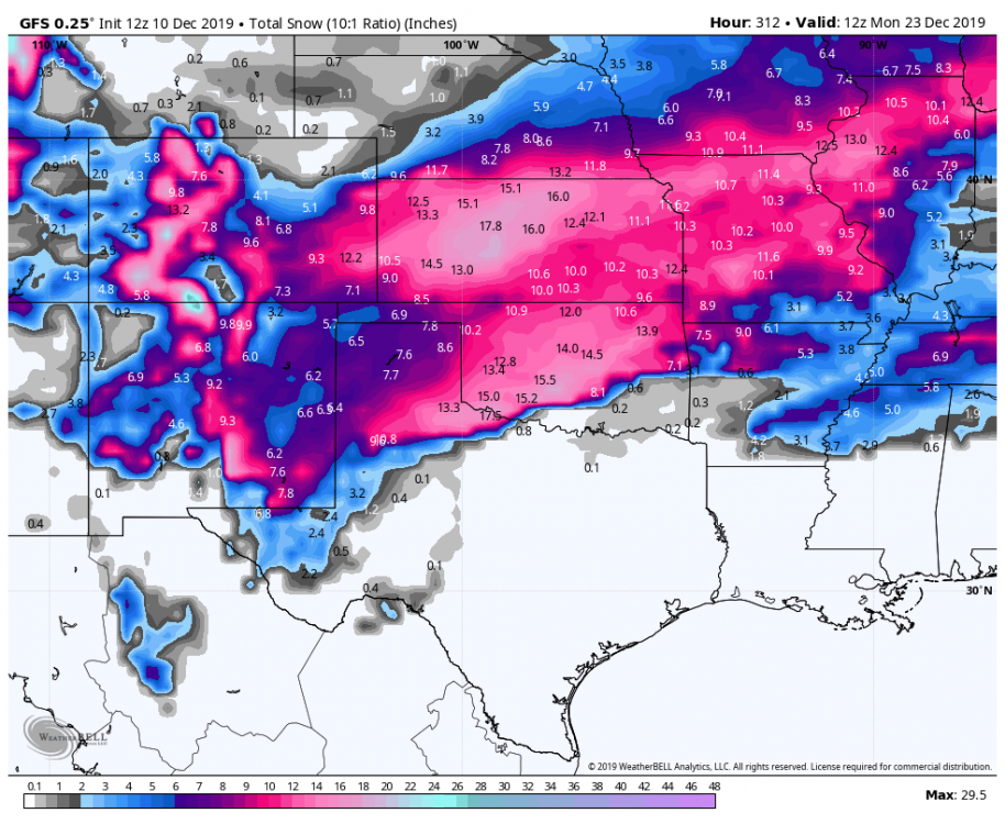
I know we are talking about 1 run on a system 9-10 days out, but this is pure eye candy. It can't even comprehend the sleet totals, lol. But the max says 7.5 inches of sleet. 2.64 inches of freezing rain 18 inches of snow.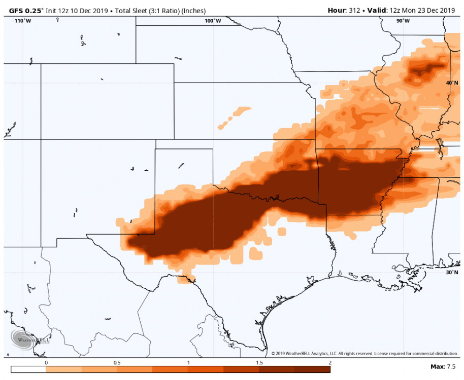

-
MO/KS/AR/OK 2019-2020 Winter Wonderland Discussion
StormChazer replied to JoMo's topic in Central/Western States
Holy cow, could you even imagine? On the shortest day of the year no less.


.png.45c7bd82300241983e1a43a53656534f.png)
.png.1d16e4e57188496506a82b11bb381056.png)
.png.c6e091cf97dd49a745936fe4df88aa8d.png)
.png.3ea328a45f6e17f36abee2bf35fad5c9.png)
.png.59a669456364b18e89dd69591a4f870c.png)