KoalaBeer
-
Posts
636 -
Joined
-
Last visited
Content Type
Profiles
Blogs
Forums
American Weather
Media Demo
Store
Gallery
Everything posted by KoalaBeer
-
If I didn’t know any better I would think a fog bank was rolling in.
-
Hampton, NH looking over the salt marsh.
-
5:50 tee time in Haverhill as well. Those cells just north of Manchester need to screw off and die out. Not on a good trajectory for me to get 9 in.
-
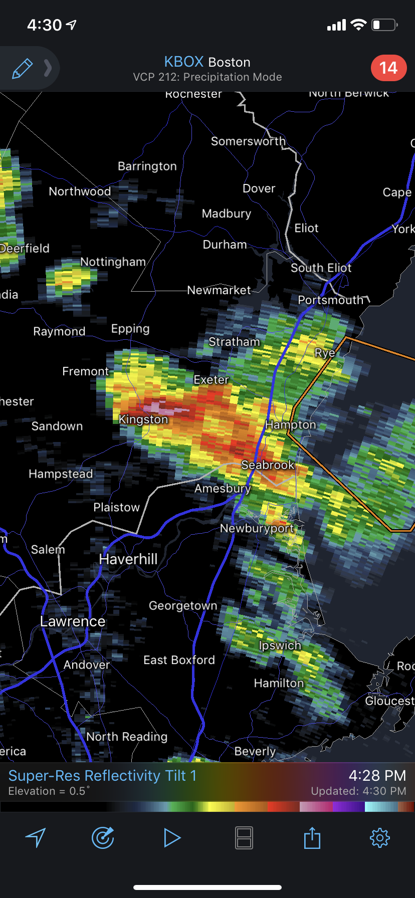
No warning on that cell in se NH with 65dbz? I bet Kingston area is seeing some good hail.
-
Jeez the Jaffrey/Keene area could be in for trouble if current radar trends hold and that heavy rain downstream moves in. Ended up being a beautiful beach day here in Hampton. Just a few showers, sitting outside with a beer now. Been in a nice radar hole all day.
-
China could have had one of there worst tornado outbreaks yesterday. Obviously tough to get much information, but the videos and damage look consistent with ef4/5. The tall apartment building reminds me of Joplin hospital damage. Click on the guys profile there’s plenty more crazy damage pictures.
-
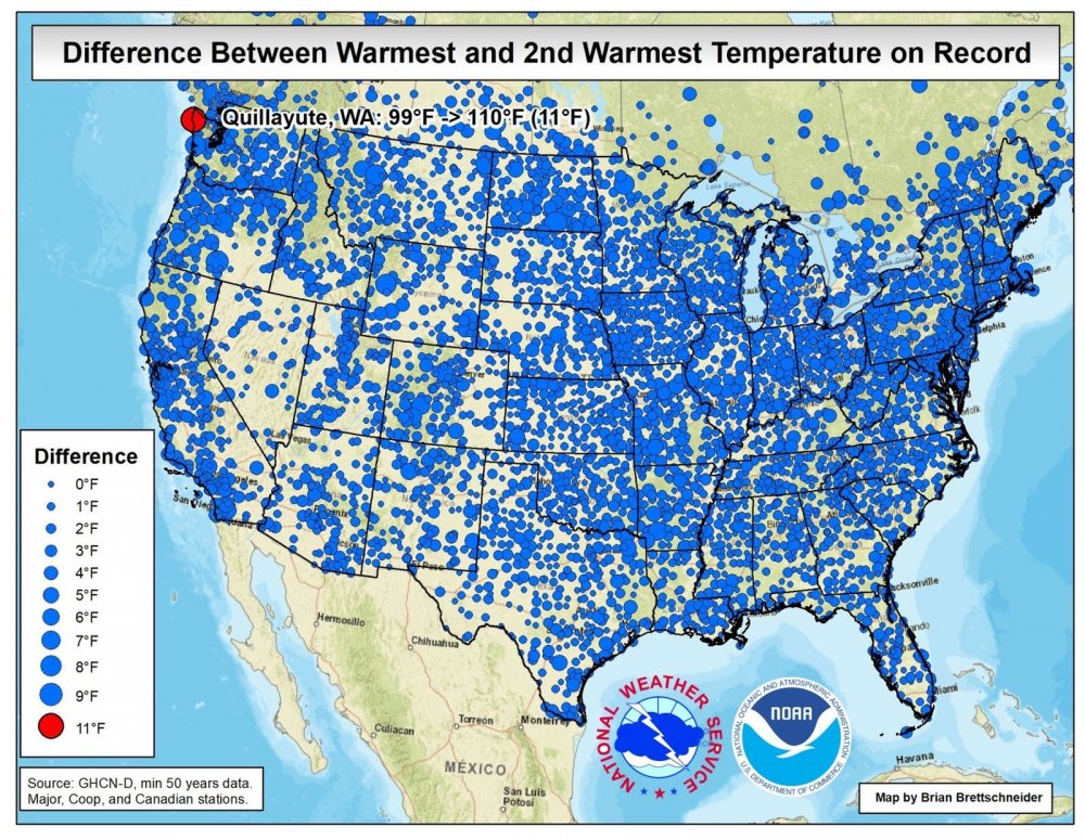
Records continue to fall out west in impressive fashion.
-
Ya that was a very impressive outing for him. I personally believe all these pitchers complaining about the sticky thing is absolute nonsense. Should of never happened in the first place so I guess MLB shoulders a lot of the blame. I’m a huge Sox fan but hopefully his performance tonight shuts up the people critical of the MLB crackdown. I will concede they should’nt have done it mid season.
-
Beautiful day on the seacoast. Cool, sunny, not humid at all. Love drinking beers on my porch and people watching the nutjobs at Hampton Beach days like today. Wtf is going on out west though. I’m afraid for them what peak fire season brings.
-
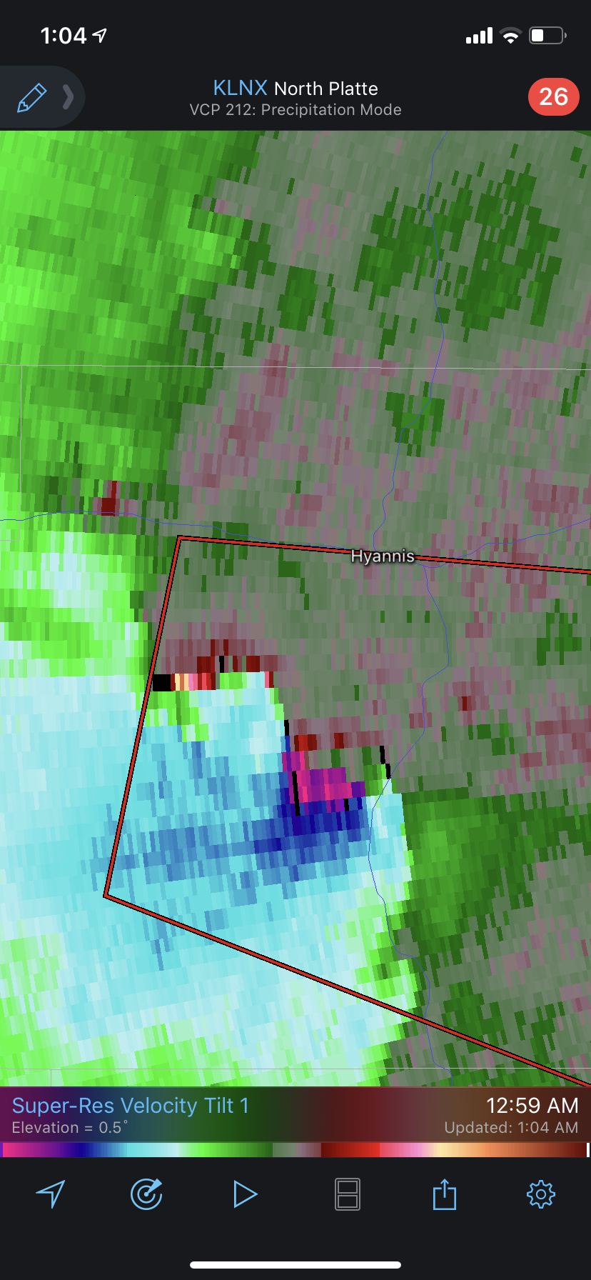
The high plains are cranking. Seems like these QLCS TORs have been more violent then normal the past few years. Rapid city radar sustained some serious damage from hail. Surprised it’s still up and running.


-
Honestly with how fast that water/mud was moving that I’m not sure he did unfortunately. That driver barely pulled away as a wall of debris game at him at like 60 mph or whatever. It was hauling ass down that hill.
-
Should be a fun little event on the NH seacoast. Not expecting much in the way of wind, but water is just about always the bigger problem for us anyways. I got a feeling this won’t be the only tropical mischief we have up this way this summer. Did anyone ever post the flash flooding/landslides from Japan this week? We are lucky to not really be vulnerable to these kind of natural disasters in our part of the world.
-
Trying to punch through this and get south. Got some good videos I’ll post later.
-
That was nastier in Hampton then what the radar let on. Probably 50-55 mph gusts. Cops are picking up all the public trash bins that flew into ocean Blvd now.
-
Radar starting to look juicy. That Jaffrey cell looks nasty and the cell by Manchester should go boom quickly as well.
-
That Pittsfield cell is showing some decent ML rotation. I’m also thinking that bowing segment moving into sw NH now could cause some wind damage downstream. It’s working into a good environment.
-
SLC is probably the best example like PowderBeard said. But if your looking for an actual violent tornado cutting through the heart of a major downtown area with high rises etc. we don’t have that on the record books as far as I’m aware of.
-
Depends what your definition of creamed and large city is. Dallas, suburbs of Chicago (just a few weeks ago) and Dayton, OH have been hit more recently. But I would put Joplin, Tuscaloosa, and Moore ahead of all those.
-
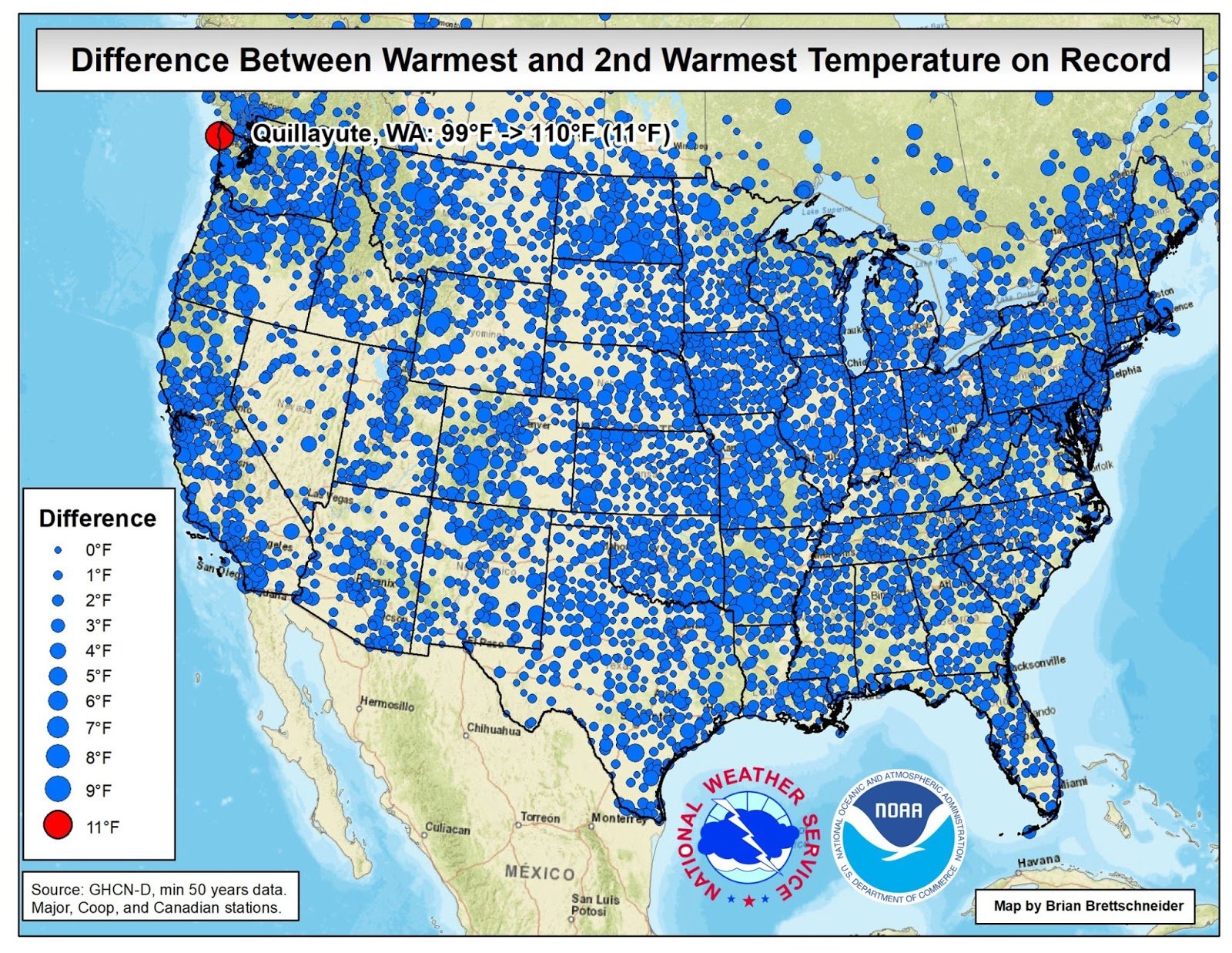
Damn Canada really feeling the effects of this heat wave out west terribly. I wonder what studies will be done after all is said and done on mortality rates out there this week. Such a synoptically impressive event but it comes with unfortunate consequences. “Canada broke its all-time national temperature record with a preliminary high of 46.6°C (116°F) in Lytton on Sunday, June 27, then beat the record again with a preliminary 47.9°C (118.2°F) on Monday. The old record was 45.0°C (113°F) from July 5, 1937. The high at Lytton is also the world’s highest temperature ever recorded north of latitude 50°N, according to international weather records expert Maximiliano Herrera.“ https://yaleclimateconnections.org/2021/06/the-cool-lush-pacific-northwest-roasts-in-death-valley-like-temperatures/
-
Nice! Reading that last spc outlook I figured we had a chance for ENH tomorrow but I didn’t want to jinx it. Looks like I won’t be getting 9 holes in after work, but I’m ok with that if I can trade off for some SVR.
-
Canada just beat the all time high of Las Vegas. Let that sink in.
-
Just silly by how much some of these records dropped.
-
Ya that’s pretty absurd. Not often the point and click has any location beating the all time heat record. The low temperatures at night are typically the average high for them this time of year.
-
Yup! 58/50 out in Hampton. Absolutely beautiful night for a fire in the backyard. Why anyone in there right mind wants next weeks heat literally blows my mind. You want 88/55 for a good beach day? Ok I’m fine with that. But 95/70 is a miserable piece of sweaty swamp ass crap. I have no AC and I’m not in a financial situation to buy one either so pound sand heat lovers.
-
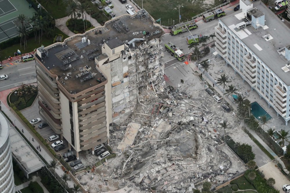
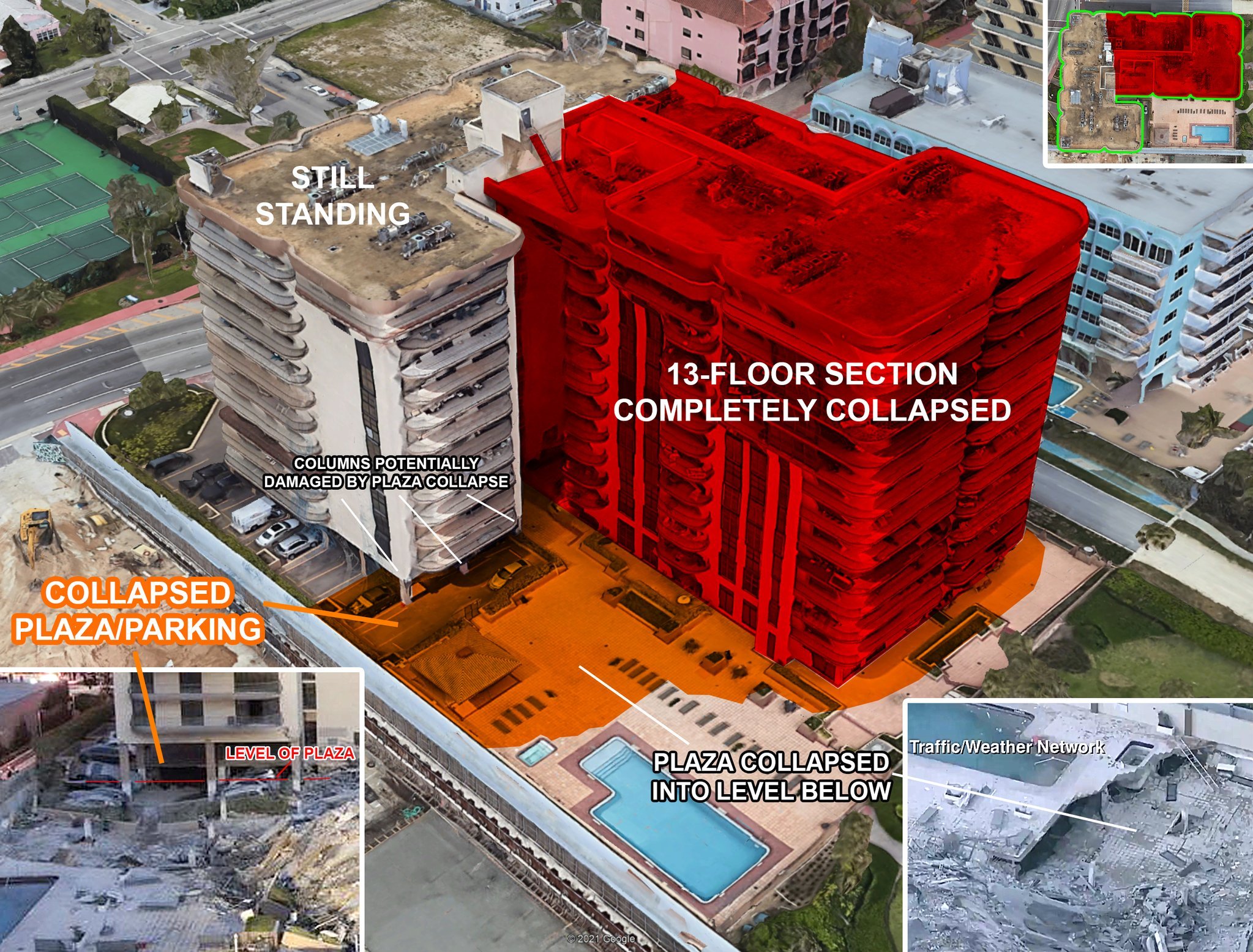
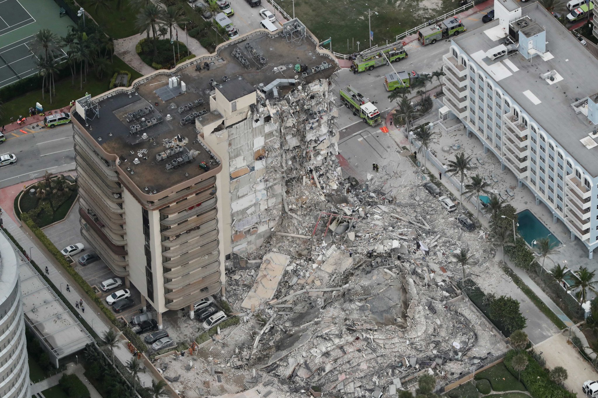
Definitely copying this into the group chat with the guys I’m playing with on Sunday. There reaction should be priceless. Thats some terrible news coming out of Florida. So many things or a combination of them could have caused that. Sinkholes, dewatering from nearby construction, seawater seeping into the foundation from the limestone its built on top of, plus construction on the roof increasing load. These pictures I pulled off twitter show the scope of how big of a section collapsed. credit- https://mobile.twitter.com/BoldlyBuilding2