KoalaBeer
-
Posts
636 -
Joined
-
Last visited
Content Type
Profiles
Blogs
Forums
American Weather
Media Demo
Store
Gallery
Everything posted by KoalaBeer
-
KLZK radar going to be very close to a direct hit. Going to be hard to track on radar as it gets closer. Looks like a significant tornado OTG on THV11 stream. Tornado emergency issued. Tornado coverage with Tom Brannon & Nathan Scott | thv11.com
-
Not my subforum but I'll be following along. Be safe today.
-
Going to be a busy day, upgrade to tornado driven high risk incoming. Mesoscale Discussion 0390 NWS Storm Prediction Center Norman OK 1037 AM CDT Fri Mar 31 2023 Areas affected...portions of southeastern Iowa...northwestern Illinois...and far northeastern Missouri Concerning...Outlook upgrade Valid 311537Z - 311630Z SUMMARY...Portions of the Moderate Risk over southeastern IA, northwestern IL, and far northeastern MO will be upgraded to a categorical High Risk in the 1630 UTC Convective outlook. DISCUSSION...An upgrade to a tornado-driven High Risk (30% probability) is expected for the 1630 UTC outlook. Environmental conditions are quickly becoming favorable to support the potential for numerous strong to potentially violent and long-track tornadoes across portions of southeastern IA, northwestern IL, and far northeastern MO. Please see the forthcoming Day 1 outlook update for more information. ..Lyons/Smith.. 03/31/2023
-

Severe Weather 3-23-23 through 3-26-23
KoalaBeer replied to cheese007's topic in Central/Western States
Thought I heard on the scanner the Exxon gas station is completely gone. That would line up well with the CC drop. Plenty of homes around there unfortunately. The scanner is heartbreaking. -
Severe Weather 3-23-23 through 3-26-23
KoalaBeer replied to cheese007's topic in Central/Western States
Amory Fire scanner link. https://m.broadcastify.com/listen/feed/37840 -
Absolutely terrible situation unfolding in MS tonight. Smithville about to get clobbered, they got hit by an EF-5 in the 2011 outbreak.
-
Severe Weather 3-23-23 through 3-26-23
KoalaBeer replied to cheese007's topic in Central/Western States
Man hopefully it avoids Smithville, don’t need to relive that horror. Terrible situation unfolding, maybe it just barely went north of Amory? Looking at google maps it looks less developed on the north side of town. -
Severe Weather 3-23-23 through 3-26-23
KoalaBeer replied to cheese007's topic in Central/Western States
Holy crap that wrapped up again really quick just now. -
Severe Weather 3-23-23 through 3-26-23
KoalaBeer replied to cheese007's topic in Central/Western States
Reed has it. -
Everyone shitting on the Euro but I’ve yet to see any data to back up it’s so called donkey ballz performance. Not saying that I have it…I’ve looked but model verification is hard to come by. Seems like there might be a little selective memory/recency bias when evaluating the models. Humans are inherently bad at correctly noting stuff like this IMO and it’s tough to trust what people ‘feel’ like they are seeing with the models without data to confirm it. To stay on topic somewhat more, glad we have a little something to track over the next week and tomorrow’s severe wx could be pretty nasty in the southeast. New MD graphics from SPC are clean.
-
Thanks for this post. It definitely irks me when people trash a model without data to back it up. Admittedly I wish that data was easier to find…I’ve had this bookmarked for a while, and I think CSU used to have a good page… https://www.wpc.ncep.noaa.gov/html/modeldiag.html#verification Seems like it didn’t matter how many times with this event pro mets told everyone to toss the clown maps in the trash, people were still treating them like the gospel.
-
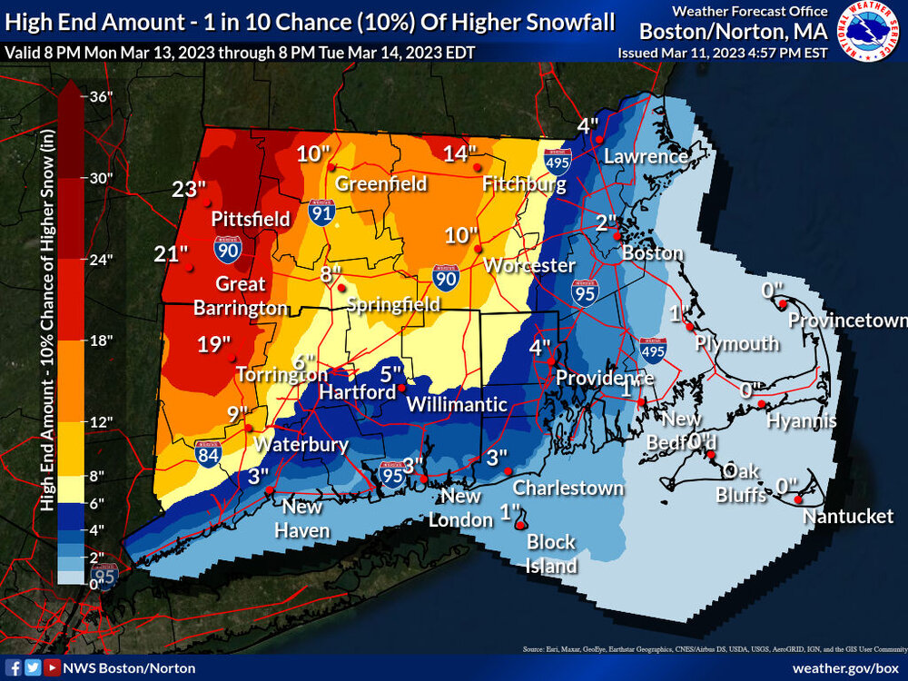
Bold call by BOX but I can see it happening.
-
15z and 16z images below for 21z show 2-3” max - again with 10:1 ratios and temps around 34/35, it was obvious to toss the clown map. Sucks you guys are getting screwed down there but listen to the pros. BOX put out 4-6 this morning and I expect that to verify most likely on the low end.
-
Buoy watching. https://www.ndbc.noaa.gov/station_page.php?station=44005
-
Has it really been that bad though? Honestly I haven’t paid a ton of attention but this is the 12z run from this morning valid 21z today showing 1-2 inches max for Boston at 10:1 which we knew to toss those ratios anyways…
-
HRRR gets going down there for a while later today through this evening. Willing to bet they get 4-6.
-
Unfortunately I don’t think I’ll make it. My sister had a kid last night and I’m watching her dog for a few days. My dogs not so happy with the visitor so I have my hands full.
-
2-3”hr type stuff in Hampton, NH. Whether it starts stacking up that quick is a different story.
-
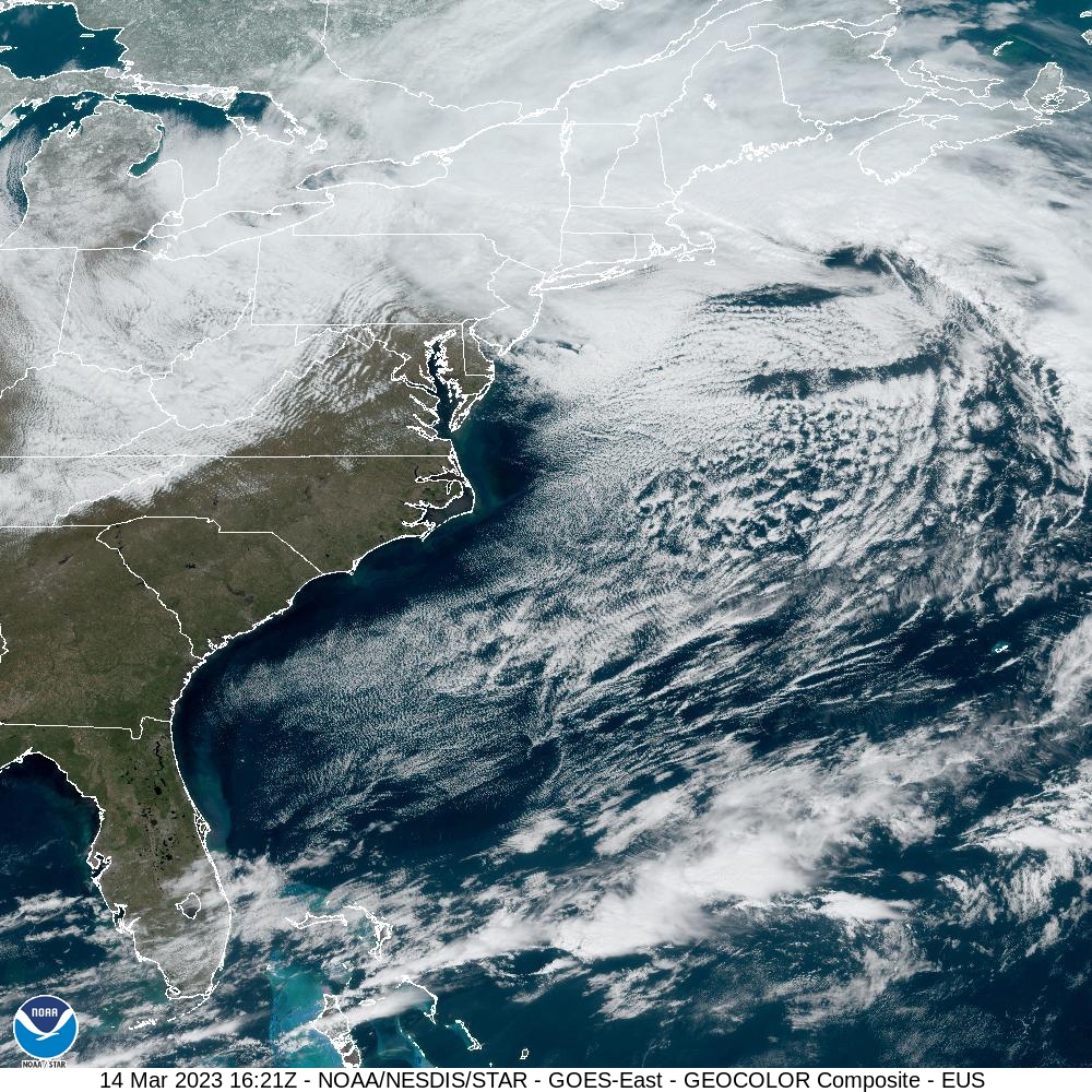
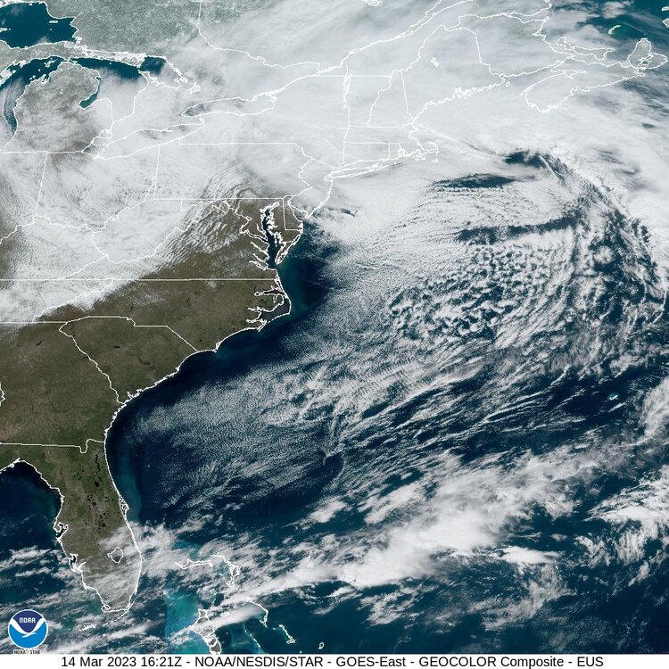
Pounding here on the seacoast of NH. Vis satellite is impressive as the capture has commenced. Almost looks like a sting jet type feature on the southern flank.
-
The last hurrah? Putting all the eggs in the Tuesday 3/14 basket
KoalaBeer replied to Ginx snewx's topic in New England

-
The last hurrah? Putting all the eggs in the Tuesday 3/14 basket
KoalaBeer replied to Ginx snewx's topic in New England
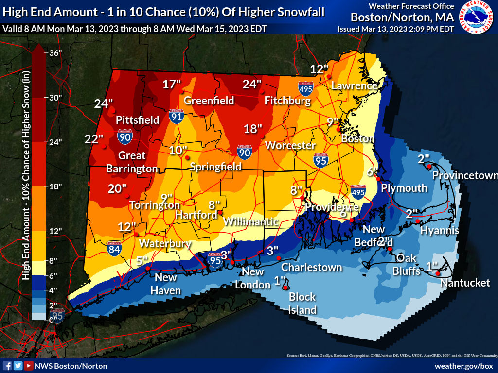
Thanks that certainly clears things up… Anyways would love to hear some mets take on that BOX map. Can’t imagine that holds especially if we are putting some more weight towards the EPS. What a nightmare forecast scenario. -
The last hurrah? Putting all the eggs in the Tuesday 3/14 basket
KoalaBeer replied to Ginx snewx's topic in New England
That was issued at 4am. Curious to see what there afternoon update is. I have low expectations here in Hampton NH but at least the waves and wind should rip. -
The last hurrah? Putting all the eggs in the Tuesday 3/14 basket
KoalaBeer replied to Ginx snewx's topic in New England
With all due respect what the hell are you talking about with this St Martin of Tours you keep mentioning? On another note I have no idea what to make of that BOX map. Curious to see what GYX update looks like. -
The last hurrah? Putting all the eggs in the Tuesday 3/14 basket
KoalaBeer replied to Ginx snewx's topic in New England
Kind of like you making a definitive statement that the possibility of that outcome is “not even close” when it’s still clearly on the table? On a different note that precip onset time is one of the grossest things I’ve seen put out by a WFO. Has to be computer generated. -
The last hurrah? Putting all the eggs in the Tuesday 3/14 basket
KoalaBeer replied to Ginx snewx's topic in New England