

CheeselandSkies
-
Posts
2,991 -
Joined
-
Last visited
Content Type
Profiles
Blogs
Forums
American Weather
Media Demo
Store
Gallery
Posts posted by CheeselandSkies
-
-
7 minutes ago, madwx said:
Probably won't fully saturate here until 7 or so. Should be some good rates between 2-6 AM
Great, might be a good day to run my dash mounted GoPro on my 2:50 AM commute into work.
-
 2
2
-
-
11 minutes ago, Jim Martin said:
Good, chip away at that severe drought area in the West. Chase season seems to be such a fine line between too dry = too much EML (everything cap busts) and too wet = not enough EML (storms go up in messy clusters at or before noon). Thankfully this Nina winter, despite its recent long dull stretch, does not seem to be trending toward the extreme Midwest dryness of 2011-'12.
-
1
-
-
27 minutes ago, madwx said:
if we get over 4" here the v16 GFS is the real winner. Was hammering the N trend for a while
Per radar, snow advancement into WI seems to have stalled in Lafayette/southern Grant Counties for now.
*Edit: Kinda odd that DVN shows it pushing into southern Dane, but MKX doesn't. Must be virga. -
Rather surprisingly, MKX went with a warning for their far SE or "KRM" counties (Kenosha, Racine, Milwaukee) for potential lake enhancement plus onshore winds (per the AFD).
-
Upgraded to slight. After downtrending quite a bit from some ominous longer range model solutions, the mesoscale has swung the ceiling for today's threat modestly back in the other direction (rather like the accompanying Midwest/western Great Lakes winter storm).
@andyhb posted a sounding elsewhere showing a significant EML on today's 12Z Shreveport sounding, the type which could move problematic should they accompany later systems that hold together better with eastward extent.
-
1
-
 1
1
-
-
1 hour ago, hlcater said:
There's significant system in the long range (~252) with a fairly decent amount of deterministic and ensemble support. Powerhouse longwave trough traverses the country during the period and assuming a neg tilt/quality ejection from the 4 corners, could lead to a significant system for someone somewhere in the midwest. Meanwhile in the warm sector, assuming moisture, the general look aloft is analogous to significant severe weather outbreaks in the lower OV and Dixie.
One of the better GEFS analogs upstairs is 2/5/2008.....


This ain't 2008 or 2011...weather just doesn't do cool **** in the midsection of the country anymore, whether winter or severe, even with a La Nina.
* Unless it's a historic derecho that just happens without any sort of lead time from the models and thus from the forecasting enterprise.
-
1
-
 1
1
-
-
1 hour ago, tuanis said:
Thread has gone quiet. Maybe we're all relishing in the Packers' loss.

Hate relying on lake effect/lake enhancement to make up for a less impressive synoptic system than progged. Can be so fickle......................./´¯/) ....................,/¯../ .................../..../ ............./´¯/'...'/´¯¯`·¸ ........../'/.../..../......./¨¯\ ........('(...´...´.... ¯~/'...') .........\.................'...../ ..........''...\.......... _.·´ ............\..............( ..............\.............\...-
2
-
 8
8
-
 1
1
-
-
2 hours ago, madwx said:
A little under 2” here overnight
Seems like less outside my window.
-
Yeah not impressed. Roads/parking lot/parked cars are mostly clear. Was anticipating a 2-3"er at some point this weekend.
-
"...just kidding." (Plugs it back in and laughs manically)
-
2
-
-
4 minutes ago, Geoboy645 said:
That cutoff on the para would be so painful. You guys get 9 while I get like 3. That would suck if that actually happened.
It seems like steep gradients in totals along both the north and south sides of the "jackpot" band are just how snowstorms work in this region. I'm guessing it's the -NAO block suppression keeping the meat of this south of us, while it's mixing issues on the south edge.
Euro had several consecutive runs with Madison getting over 11" going into Thursday morning, then dropped us to less than 2".
-
53 minutes ago, hlcater said:
and the para. Essentially in lock step with the operational.

Except the 5" difference for Madison, lol. I've seen anything from over 9" to less than 0.5" on the solutions posted within just the last couple hours. @madwx, make it make sense!
-
1
-
-
4 minutes ago, Hoosier said:
Noticeable thinning of the heavier snow band. Hopefully we can end up with something a little wider.
From 11.3 to 1.7 for us @madwx.

-
1
-
1
-
-
1 minute ago, madwx said:
I'll get my 2" from the wave on Saturday night and I'll enjoy it.
Also Pivotal has Kuchera for the Euro now.
There's that slide south, perfect timing lmao.
-
Why can't the Euro be king anymore?
-
6 hours ago, Geoboy645 said:
I mean 13-14 was like that here too. Madison never reached a foot of snowpack the entire winter which is pretty surprising all things considered. Then again we didn't quite get the major storms that either Chicago or Detroit had. We "only" had 57" that winter.
Which is why I don't remember that winter being so impressive, just miserable f**king cold for way too long without a break.
-
7 hours ago, Stebo said:
No but I would love a week of 70+ in April every once and a while. The last 3 April combined have had 7 total and 0 80s.
My ideal April day is 74/68 with a high risk of severe thunderstorms. When has that happened in this region in the last 20 years?
-
1
-
-
1 hour ago, Spartman said:
00z Euro is pretty much on its own.

Remember when the Euro showed something happening, you sat up and took notice?
-
2
-
-
2 hours ago, andyhb said:
 re: Spring tornado chances. 2008/2017 would be more promising though.
2014 wasn't bad considering the slow start (although frustrating for me since I missed the Pilger family by an hour and targeted Iowa the following day, but at least the opportunity was there). There were a number of high risks in 2001 but they generally busted.
2017 was meh, but actually one of the better post-2015 seasons, sadly. The event of the year locally happened before I was ready for it (February 28th).
-
34 minutes ago, Stebo said:
I wouldn't go down to 200 per day, but could we get down to 1000 by say May? I think so. Maybe even 500 or less during the summer. If the vaccine can be distributed much quicker then less.
Great, down to a 4/27/11's worth (give or take a hundred) of deaths per day and that'll be great progress.
This whole thing has really made weather seem a lot less awe-inspiring (that combined with the extended period of atmospheric suckitude in the central CONUS).-
1
-
-
You know it's bad when Angry posts something that makes sense.
-
1
-
1
-
-
5 hours ago, andyhb said:
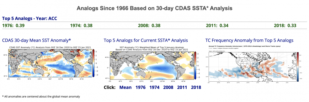
Looks like Tropical Tidbits has their SSTA analogs up and running again. That would certainly be a favorable set for an active severe weather season, especially early season.
On the other hand, rapidly decaying Ninas in 3.4 over the past 20 years have been very unfriendly to the Plains in peak season, as such years consist of 2006, 2009, 2012, 2017, and 2018.
About as stark a contrast as you can get between those two sets of analogs. I sure as hell don't know what to make of it. Granted ENSO isn't the only large-scale driver of severe weather potential but it'd be much more confidence-inspiring to see things leaning more 1974/2008/2011-ish than 2006/09/12/18, although the line seems rather fine. Also, at least anecdotally, 2012 behaved nothing like the other years in that group being extremely warm and dry throughout the central CONUS from March through about September.
Also, shouldn't this be "2021 ENSO" by now? Seeing as we skipped over 2020.
-
13 minutes ago, hlcater said:
the 2nd dose blows. That's all im gonna say.
Which one did you get?
-
2 hours ago, CheeselandSkies said:
Wasn't it supposed to be snowing by now?
Finally coming down here, pavement and parked cars lightly coated.

Jan 25-26th Potential Something Part 3
in Lakes/Ohio Valley
Posted
IC getting buried while CR gets nada...sound about right @hlcater?