

CheeselandSkies
-
Posts
3,243 -
Joined
-
Last visited
Content Type
Profiles
Blogs
Forums
American Weather
Media Demo
Store
Gallery
Posts posted by CheeselandSkies
-
-
48 in Milwaukee rn, so glad I no longer live there.
-
2 hours ago, madwx said:
warm front mixed n of here in the past hour. Jumping from the upper 50s to the low 70s. Gonna make a run at 80 today
IMO it should look and feel outside like it does here rn every day from now until the summer solstice.
-
 2
2
-
 1
1
-
-
6 minutes ago, Indystorm said:
We can always go and read web pages dealing with 4/27/11 for a needed fix.
Oh, believe me, that is happening.
-
1
-
-
6 hours ago, cyclone77 said:
Still 71 as we approach midnight. Feels like a summer evening.
Still waiting on the first slight risk of the season. Don't recall making it into May without being in one but I'm sure it's happened. Very benign spring to say the least.
Seems to be the default mode now. How bogus is it that we have a warm front draped across southern Wisconsin in late April, we're expected to nearly hit 80, and we don't have a substantial
 threat? My lifelong interest in following the weather is rapidly dwindling.
-
1
-
1
-
 1
1
-
-
11 minutes ago, stormdragonwx said:
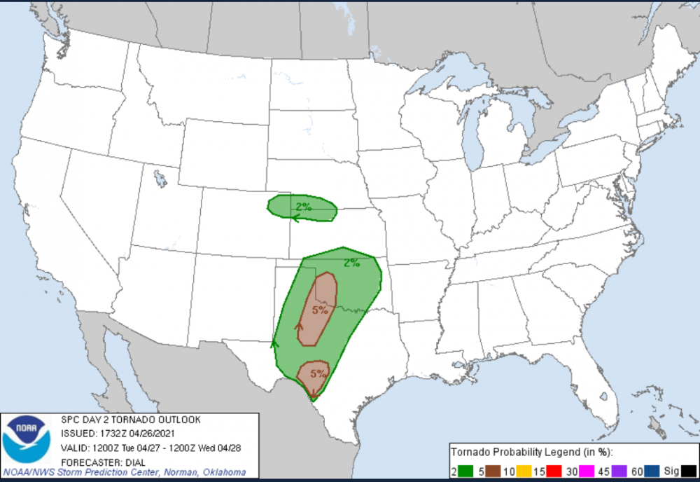
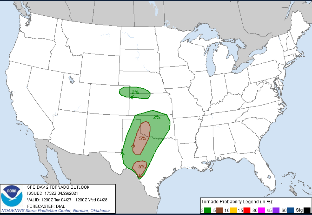
Here's the current D2 outlook. Got a slight risk area with a 5 percent tornado. Storm chasing potential is trending more and more into the "meh" category for me. Might sit this one out but I'll have to look at the data closely tonight.
Like last Friday, should be a good day for the OK/TX-based chasers to get out and maybe (long shot) luck out with a storm like that Quanah/Lockett one. Not really worth traveling from outside the area, especially since it's looking like a one-and-done as opposed to a sequence of chase days (might be something somewhere Wednesday but details are looking very nebulous at this point).
-
1
-
-
12Z 3KM NAM has a nice fantasy warm front rider in northern Illinois Wednesday afternoon.

-
I've heard rumblings just a few days ago of the MJO going through a favorable progression for CONUS severe weather. Is this no longer expected to happen, or are there other factors at play that are expected to negate its impact?
-
Not quite sure how most local mets (MKX/broadcast) along with SPC are totally dismissing severe potential into the upper Midwest region Tuesday afternoon/evening with forecast soundings like this:

-
NAM isn't real impressive for Tuesday afternoon/evening. Has pretty much zero instability over the area where SPC has the threat outlined.

-
1 hour ago, Powerball said:
Potentially.
Models are still struggling with how progressive the trough will be.
Tuesday evening is within NAM range now, it joins how the GFS has been for quite a while with this system in portraying not much CAPE despite a broad warm/moist sector. Ironically it likewise shows one of the more unstable areas being over MBY, while the local forecast office and broadcast mets have not sounded impressed on severe potential around here.
-
KFDX live coverage:
https://www.texomashomepage.com/live-stream/I think that's the guy I watched after stumbling into a shady motel room in Wichita Falls on 5/20/19 wondering what the heck just happened.
-
23 minutes ago, cheese007 said:
Seems to be back
Hearing them talk about "two tornadoes" down, but can't see anything due to buffering. Radar looks impressive, though.

-
If this storm holds together on that track it could be a threat to the Vernon, TX area. Good thing parameters don't really support long-track tornadic supercells in that area today, but something to keep an eye on.
-
1 minute ago, cheese007 said:
Seems to be back
Oh nice, that is a Plains classic. Already better than 5/20/19, lol.
-
4 minutes ago, TimB84 said:
I don’t disagree with your point that we still have yet to know what effect this pandemic will have on the suicide rate in 2021 (or 2022 or 2023). But we can’t definitively say it will go up, or go down, or stay the same as the (like you said) already horrific baseline. But evidence that suicide rates have gone down so far makes those who categorically state things like “pandemic restrictions will cause (or are causing) the suicide rate to skyrocket” look all the more ludicrous. It’s no longer just that those claims are unsubstantiated, it’s that there is now evidence to the contrary.
I admit the first couple months of total lockdown were pretty depressing, and that was just from stir-craziness. My fiancee and I were never at risk of losing our livelihood (I'm in broadcast media, she's a social worker).
-
1
-
-
1 minute ago, cheese007 said:
https://texasstormchasers.com/2021/04/23/4-23-2021-live-storm-chase-childress-tx-storm/
Live shot of the Quanah storm
TOG, nice classic funnel.
Edit: Brief, but looked good for a minute there.
-
This one looks like it could get it done. Either way, should be a nice photogenic supercell to be on.

-
55 minutes ago, Chicago Storm said:
2012 was great.
.There's always gotta be one...

-
Well, that alone would work against a 2012 analog, at least in this part of the country, lol.
-
1
-
-
15 hours ago, IWXwx said:


Elaborate, please.
-
13 minutes ago, WestMichigan said:
Does anyone know what the highest percentage recorded is for at least some level of drought in the lower 48? This is not a good way to enter summer with that much D0 and higher on the map.
Just anecdotally 2012 was way worse by this point already, although I don't remember the percentages.
-
11 minutes ago, jojo762 said:
00z ECMWF last night continued to show a highly volatile setup from NE KS into western OK and down into TX.


From a synoptic-scale it really does not get much more obvious than this.
Euro depicts the 70-80kt mid-level jet core impinging across the dryline by 00z with a 40-50kt southerly LLJ east of the dryline. The warm-sector on the euro is quite expansive, characterized mostly by mid-60s dewpoints and strong instability.
Parts of the dryline are plagued by strong CINh, and this is well seen in the euro QPF fields hinting at limited coverage along the dryline in OK and TX and coldfront in KS.

This would not qualify as a true write-up about the 00z Euro if it did not feature at least one cherry-picked, "eye candy" sounding. (roughly halfway between Woodward and Elk City)

Since I do not pay to access the EURO soundings on Pivotal, my analysis has been limited to the GFS which has been intent on showing a very deep trough with strongly meridional 500mb flow, and a more subdued ceiling for the event as a result. The Euro also appears to show a secondary surface low in SE NE with a warm front extending into Iowa (and the GFS, for all its flaws with the setup as portrayed, has been consistently showing some of the strongest warm sector instability over N IL/WI/MN/IA), so it could be a potential regional chase for me since I get out of work at noon Tuesday and have Wednesday off.
-
We'll see how much action happens in this sub, GFS has consistently been very amped with the trough next Tuesday/Wednesday resulting in highly meridional 500mb flow. It has also been consistent with wanting to get the moist sector pretty far north yet showing large areas of it with nil SBCAPE.
-
1
-
1
-
-
Just had a brief but vigorous snow shower here. No accumulations that I can see but visibility was kind of dicey there for a minute. @madwx
-
1
-


What weather can we expect for May 2021?
in Weather Forecasting and Discussion
Posted
The header says March?