

George BM
-
Posts
2,603 -
Joined
-
Last visited
Content Type
Profiles
Blogs
Forums
American Weather
Media Demo
Store
Gallery
Posts posted by George BM
-
-
39 minutes ago, WxWatcher007 said:
This is WxWatcher007 reporting live from Chiefland, FL, just inland from Cedar Key. We have a hurricane warning here and folks are taking the storm seriously. The forecast for the center is very tricky even now, as some models have been trending westward toward a near direct hit of Tallahassee while others are further east down to Cedar Key. The parallel track along the west coast of Florida makes this hard. I am hedging east right now, but am prepared to move north if necessary this evening. Will monitor trends.
As is usually the case, my friend @MillvilleWx is in communication with me, and this time I'm grateful to have @ORH_wxman supporting as well. If I lose power and internet, I'll be in touch with them so that everyone here knows I'm ok.
Driving in last night there was a wicked storm to my south. Perhaps a preview...

Have fun!... obviously ditto to what Mappy said above as well.

-
Any forum members chasing this?
-
1 hour ago, Mrs.J said:
My parents are now under a mandatory evacuation in Manatee County for Level A. I think they will be heading to my sisters in Atlanta like last year.
Best of luck to your parents.
-
 2
2
-
-
000
WTNT65 KNHC 271513
TCUAT5

Tropical Storm Idalia Tropical Cyclone Update
NWS National Hurricane Center Miami FL       AL102023
1015 AM CDT Sun Aug 27 2023


...DEPRESSION STRENGTHENS TO A TROPICAL STORM...

Observations from a NOAA Hurricane Hunter aircraft indicate that
Tropical Depression Ten has strengthened into Tropical Storm Idalia.
The maximum winds are estimated to be 40 mph (65 km/h) with higher
gusts.

SUMMARY OF 1015 AM CDT...1515 UTC...INFORMATION
---------------------------------------------------
LOCATION...19.9N 85.8W
ABOUT 80 MI...135 KM ESE OF COZUMEL MEXICO
MAXIMUM SUSTAINED WINDS...40 MPH...65 KM/H
PRESENT MOVEMENT...E OR 90 DEGREES AT 2 MPH...4 KM/H
MINIMUM CENTRAL PRESSURE...996 MB...29.41 INCHES

$$
Forecaster Pasch
-
3
-
-
97/68 currently at IAD tying the record high for today.
-
Looks like we have a chance of elevated convection/thunder w/ the main chances coming tonight/early tomorrow morning and again early Friday morning. NW-flow regime... elevated style.
-
2
-
-
This morning the air was uncomfortable for serious running, pre-dawn.
Now it's only 5-7F warmer than it was during the 5am hour w/ dewpoints nearly 20F lower w/ the breeze making it feel like September.
Overall, a fairly similar day to this past Friday.
Currently IAD at 82/49.
-
2 hours ago, WxWatcher007 said:
Should have Franklin at 5pm with Invest 90L. Recon finding TS winds and I think enough of a closed circulation.
Yeap.
000
WTNT33 KNHC 202053
TCPAT3

BULLETIN
Tropical Storm Franklin Advisory Number   1
NWS National Hurricane Center Miami FL       AL082023
500 PM AST Sun Aug 20 2023

...TROPICAL STORM FRANKLIN FORMS IN THE CARIBBEAN SEA..
...TROPICAL STORM WATCHES ISSUED FOR THE SOUTH COAST OF HAITI AND
THE DOMINICAN REPUBLIC...


SUMMARY OF 500 PM AST...2100 UTC...INFORMATION
----------------------------------------------
LOCATION...14.6N 67.1W
ABOUT 270 MI...435 KM SSE OF ISLA SAONA DOMINICAN REPUBLIC
ABOUT 270 MI...435 KM SSW OF SAN JUAN PUERTO RICO
MAXIMUM SUSTAINED WINDS...45 MPH...75 KM/H
PRESENT MOVEMENT...WNW OR 290 DEGREES AT 14 MPH...22 KM/H
MINIMUM CENTRAL PRESSURE...1002 MB...29.59 INCHES
.....
-
1
-
-
1 hour ago, CAPE said:
After 2 weeks away was thinking of doing a bit of mowing (as nice as it feels out now), but a couple drinks in + weed, eff that. With the mixing/lowering dews, should be prime mowing weather around 6am- about 60 f.
That's one advantage of living relatively isolated from others.
-
3
-
-
7 minutes ago, WxUSAF said:
I want the entire 18z gfs verbatim please
A little bit of everything for all preferences verbatim.
-
Severe Thunderstorm Watch coming out until 9pm for much of the area.
-
1
-
-
~1.45" in the gauge from yesterday.
Brief gusts into the low 40s(mph) w/ the initial line... pedestrian IMBnFY.
-
This got lost in the severe tracking but that 12z GFS run for Friday the 18th was total lolism. Temps in the mid 80s+ at the crack of dawn w/ 110+F highs across the region during the afternoon.

OBVIOUSLY 18z is more realistic with no Desert SW-like heat.
-
 1
1
-
-
Going on 270 posts in the severe thread today w/ storms not even in the main region yet. Impressive winter-like activity.
-
2
-
-
IAD up to 89/74.
-
Tornado Watch for the region until 9pm.
-
Just now, Eskimo Joe said:
What product on the IEMBot site did you use to get that?
It's actually from the same link you shared yesterday. Thanks for that, btw.
")
-
1
-
-
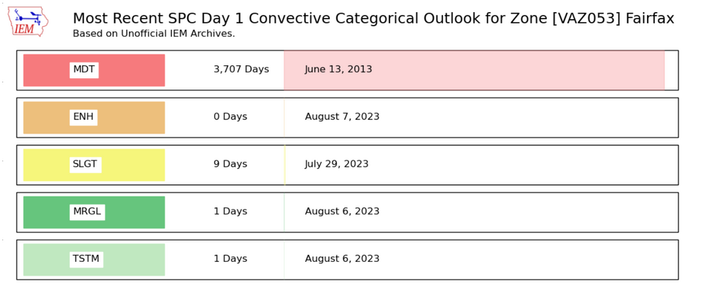

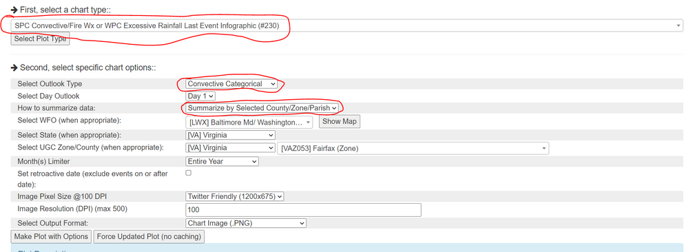
3,707 days. It's been a while.
-
1
-
 3
3
-
-
4 minutes ago, Stormfly said:
When was the last time we were in moderate?
June 13th, 2013.
-
4
-
-
...OH Valley to Mid-Atlantic to the southern Appalachians and
   Carolinas...
   Scattered showers and isolated storms are forecast to be ongoing
   over the OH Valley Monday morning with more widely spaced convection
   trailing west-southwest into the Mid South/Ozarks.  Considerable
   cloud cover with northward extent over a large moist/warm sector
   will limit destabilization into portions of PA and north.  Farther
   south, heating of a very moist boundary layer will yield a moderate
   to very unstable airmass (1500 to 3000+ J/kg MLCAPE) from PA
   southward into the southern Appalachians.

   Multiple bands and clusters will likely begin to develop towards
   midday over the upper OH Valley and central Appalachians.  Less
   certain is convective timing over the TN Valley where a large spread
   of model solutions is currently depicted.  Nonetheless, scattered
   thunderstorms will likely develop by early to mid afternoon and
   become quite extensive from northern AL/GA into PA/VA/WV/MD.  A mix
   of semi-discrete cells and clusters are possible initially and a
   risk for all severe hazards is expected given favorable shear
   profiles for storm organization/low-level rotation.  Upscale growth
   is expected as storms move into the northern VA/MD and Chesapeake
   Bay vicinity during the late afternoon/early evening where the wind
   risk will seemingly be maximized.  Much of the activity will
   eventually move east of the Mid-Atlantic coast during the evening
   and areas farther south through the Carolina Piedmont and into the
   coastal plain.
Fun sounding disco for this region.
-
45% Wind for tomorrow.

-
2
-
-
MJJ ONI: 0.8C (nearest tenth deg)
MJJ RONI: 0.33C
-
3
-
-
1 hour ago, MillvilleWx said:
We are home. Maryland never felt so good!!

Where are you now? Northern MD?
-
A band of relatively thick smoke is currently moving overhead. It looks like it's overcast and the sunlight is very dim and orangish.

Hurricane Idalia
in Tropical Headquarters
Posted
It's actually 968mb at the surface on that sonde... there's just no wind data at the very surface for some reason... so probably good for 967/966mb.