

George BM
-
Posts
2,603 -
Joined
-
Last visited
Content Type
Profiles
Blogs
Forums
American Weather
Media Demo
Store
Gallery
Posts posted by George BM
-
-
Dark and strange...
-
The smoky haze will make its return later today and likely be around through at least tomorrow.
-
 1
1
-
 1
1
-
-
DCA: 105F
IAD: 103F
BWI: 106F
RIC: 104F
-
13 named storms
6 hurricanes
3 major hurricanes
13/6/3
-
I believe this may be the first MRGL+ from SPC for parts of the area since April IINM?
-
Surprisingly IAD is still at 90F atm.
-
I just realized that the record at IAD for today is 91F tied in 2009.
So IAD has broken the daily record by 2F thus far.
-
1
-
-
IAD up to 93F so far.
-
1
-
-
107
WTNT32 KNHC 021738 CCA
TCPAT2

BULLETIN
Tropical Storm Arlene Special Advisory Number   5...Corrected
NWS National Hurricane Center Miami FL       AL022023
100 PM CDT Fri Jun 02 2023

Corrected wording in Hazards Affecting Land section

...AIR FORCE HURRICANE HUNTERS INDICATE DEPRESSION HAS STRENGTHENED
INTO TROPICAL STORM ARLENE...


SUMMARY OF 100 PM CDT...1800 UTC...INFORMATION
----------------------------------------------
LOCATION...26.7N 86.2W
ABOUT 265 MI...425 KM W OF FT. MYERS FLORIDA
ABOUT 340 MI...550 KM NNW OF THE WESTERN TIP OF CUBA
MAXIMUM SUSTAINED WINDS...40 MPH...65 KM/H
PRESENT MOVEMENT...S OR 175 DEGREES AT 5 MPH...7 KM/H
MINIMUM CENTRAL PRESSURE...1002 MB...29.59 INCHES


WATCHES AND WARNINGS
--------------------
There are no coastal watches or warnings in effect.


DISCUSSION AND OUTLOOK
----------------------
At 100 PM CDT (1800 UTC), the center of Tropical Storm Arlene was
located near latitude 26.7 North, longitude 86.2 West. Arlene is
moving toward the south near 5 mph (7 km/h) and this motion is
expected to increase slightly through tonight.

Maximum sustained winds have increased to near 40 mph (65 km/h)
with higher gusts. Arlene is expected to weaken by tonight, and it
is forecast to degenerate into a remnant low on Saturday.

Tropical-storm-force winds extend outward up to 70 miles (110 km)
northeast of the center.

The estimated minimum central pressure based on data from the Air
Force Hurricane Hunters is 1002 mb (29.59 inches).


HAZARDS AFFECTING LAND
----------------------
RAINFALL: Rainfall amounts of 1 to 2 inches with localized higher
amounts up to 5 inches are possible through Saturday across portions
of the central and southern Florida Peninsula.  This rainfall is not
directly related to Tropical Storm Arlene.  Regardless, the heavy
rainfall could lead to isolated flash, urban, and small stream
flooding impacts.


NEXT ADVISORY
-------------
Next complete advisory at 400 PM CDT.

$$
Forecaster Cangialosi/Hogsett/Delgado
-
1
-
-
12 minutes ago, yoda said:
89 at 1pm
IAD was 89, BWI 92
IAD has hit 90F via 1-min obs.
-
32 minutes ago, WxWatcher007 said:
I think we have enough.
Bring us home!
-
Happy Meteorological/Climatological summer!
Happy Hurricane Season!
-
1
-
-
Hurricane Idalia Advisory Number 32
11AM EDT Friday, August 25, 2023
Max Sustained Winds: 230mph, Gusts: 280mph
Moving: NNW(345*) at 29mph
Min Sea-Level Pressure: 832mb
Idalia has taken advantage of the 35-36C SSTs off the southeastern US w/ limited shear and a moist environment available and has become an unprecedently catastrophic category 5. Idalia will race inland over the Carolinas and northwards over the Mid-Atlantic region through the day ahead of an advancing through coming out of the west and will blast into the interior northeast and southeastern Canada by late this evening. An unfathomable storm surge of upwards of 50 feet is expected along the North Carolina coast from Wilmington to Morehead City with a catastrophic surge up the Chesapeake Bay all the way up through Long Island, NY. Hurricane Warnings extend north through the Carolinas, Mid-Atlantic, northeast and into southeastern Canada and the Great Lakes.
Rainfall will easily total 1 to 2 feet in these areas w/ localized amounts upwards of 3 feet in the Appalachians. Widespread hurricane-force winds will cause extreme wind damage through the warned area with extreme (115+mph winds) extending as far inland as places such as Toronto, Canada and Syracuse, NY.
Satellite Image: 10:50AM EDT August 25, 2023
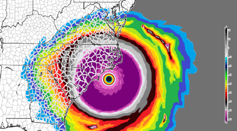
Them dastardly underwater volcanoes at it again.

-
5
-
 4
4
-
 1
1
-
-
The batch of high clouds moving overhead should make for a gorgeous sunset this evening w/ little/no additional cloud cover to the WNW (sunset-direction).
-
1
-
-
On 5/30/2021 at 7:19 PM, George BM said:
I'm -4 today.
Now I'm -2...
-
5 minutes ago, Kmlwx said:
Super long range GFS for June 13th has what looks like an EML plume potential severe event. It has been hinted on a few runs here and there the last few days but at that range - nothing consistent. Good mid-level lapse rates would be a rarity to see around here...paging @Eskimo Joe
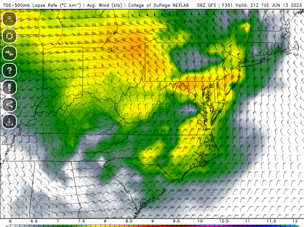
I heard thunder for the first time this month yesterday.
Though not to this extent AND not implying that the pattern will repeat but... I remember 2012 being quite convection-wise before the end of May into June.


-
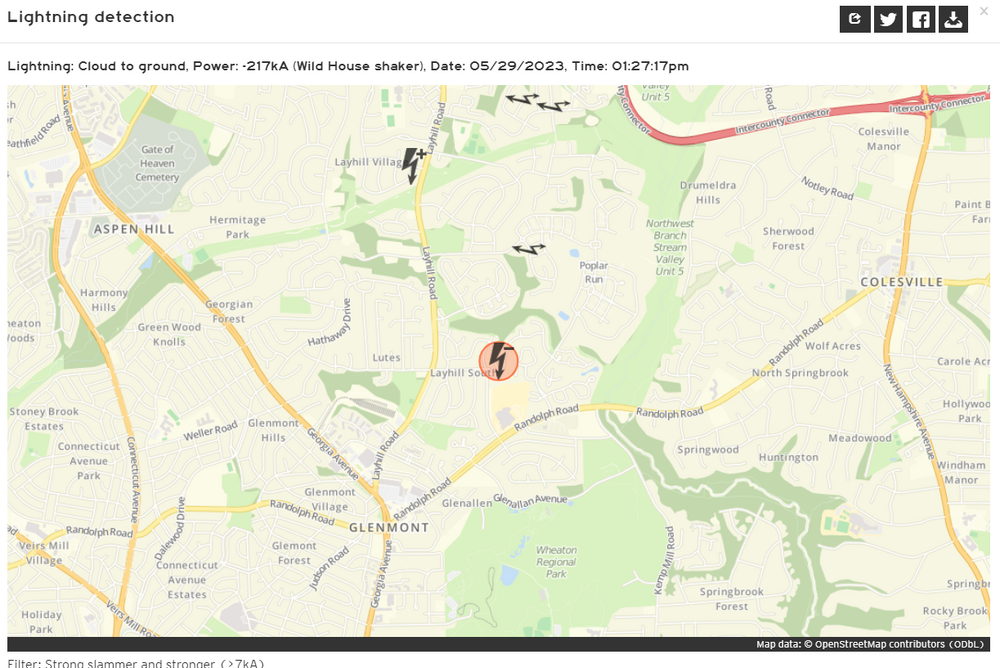
2 hours ago, The Dude said:
Nice! Where is that graphic from?
weather.us/lightning
A good free site for seeing lightning activity over the past 24 hours.
-
 1
1
-
-
44 minutes ago, weatherCCB said:
Loud booming thunder here.
only light rain so far
Strong negative CG.
-
There's a good chance that I won't hear a single rumble of thunder this month. Not to common to not hear any thunder in the month of May here.
There may have been audible thunder at my location on the 20th but I was busy doing some things and didn't notice.
-
15 hours ago, Amped said:
Oh no, not grass!!!!
Different view of the same dust devil.
-
1
-
-
8 hours ago, MillvilleWx said:
Hey everyone! Just letting y'all know that my wife and I will be in the area sometime in August until potentially forever because I got the job at the Weather Prediction Center!!!
I AM COMING HOME!!!

Extreme Congratulations!
A Severe Celebration Warning is in effect.
-
3
-
-
This will be the last of the smoky haze for a bit.
Definitely the haziest May that I can remember... at least when it comes to smoke being aloft in the atmosphere.
-


54/52 at IAD as of last hour w/, of course, hazy skies.
-
5 hours ago, Herb@MAWS said:
Satellite and wind vector maps suggest a small circulation possibly developing just east of Mayaguana in The Bahamas on 5/21/23 in the morning.
Indeed. Probably not much happening with it but NHC has a 10% lemon on it.


June Discobs 2023
in Mid Atlantic
Posted
Okay, this is some of the thickest smoke aloft that I've seen here thus far. The sun is still relatively dark and deep orange/pink two hours after sunrise.