

George BM
-
Posts
2,610 -
Joined
-
Last visited
Content Type
Profiles
Blogs
Forums
American Weather
Media Demo
Store
Gallery
Posts posted by George BM
-
-
Just now, high risk said:
confirmed TOR on that Delaware cell
With a debris ball.
-
1 minute ago, midatlanticweather said:
And- We got a warning!
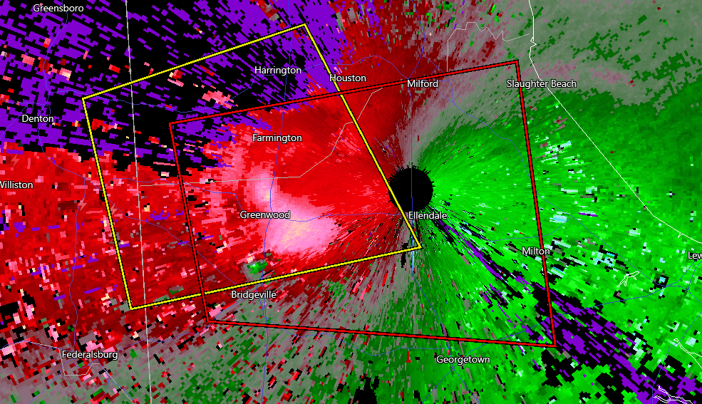
There's definitely a tornado on the ground with that.
-
Just now, Eskimo Joe said:
Got a link? I'm mobile.
-
 1
1
-
-
Am I the only one who's, perhaps irrationally, mildly annoyed that the February 1st event ruined our chance at a total 0" shutout year at the local airports?
Also... That feeling when your low-end troll forecast ends up too high at the three local airports.
 On 11/28/2022 at 5:33 PM, George BM said:
BWI: 3.5"
DCA: 0.9"
IAD: 3.1"
RIC: 6.0"
Tiebreaker (SBY): 6.2"
-
 1
1
-
-
Looks like April will be the month coming in like a lion this year.
Happy Pollen Sufferers Awareness Month to those who celebrate!
-
George BM: We’re gonna get SHELLACKED by wind! I can’t wait to get outside and shovel feet and feet of wind. All my neighbors will be cowering in their houses while I’ll be outside climbing tall trees and getting a free rollercoaster ride without waiting in all d’em lines or spending me money! And then… I’ll become one of only a handful of humans to take flight with no assistance from jetpacks, waterjets or any of that mumbo jumbo! Peeps brave enough to be outside across the region will wonder what kind of huge bird that is flying over them. But it’s just gonna be ME looking as elagant as an A400M! Everywhere they look it’s me! Then once I’ve mastered flying I’ll land and go from downed tree to downed tree yeeting them into woodchippers across the region bulking up my muscles as I go. By the time that’s all said and done I’ll be the strongest human in the galaxy!
Alpha: BIG cringe.
George BM: @Alpha
 Just shut up and enjoy the wind!
GeorgeX: Na, I'm with alpha. You're trying too hard.
George BM: Y'all the point is that it's going to be very windy. That's it and nothing more. Leave me alone.
-
 7
7
-
-
Just now, Eskimo Joe said:
Biggest convective gust I witnessed was in Philly as a kid. We got a severe t'storm warning from a low topped line of convection. Only had 1 rumble of thunder, but got a M63 mph wind gust that took down huge trees and damaged a church steeple in my neighborhood.
I would ask whether it was the Nov. 20, 1989 low-dewpt derecho but I believe that may have been before your time(?)
-
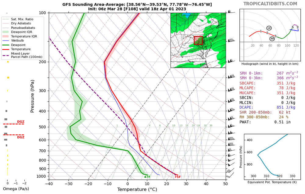
Long-range HRRR which I, usually anyways, find does well with wind gusts in a well-mixed environment like tomorrows has 45-50+kt gusts w/ the frontal passage. A short-lived HWW or, like MN Transplant just mentioned, an April 30, 2021-like situation w/ STWs wouldn't surprise me. But I'm just reiterating what everyone has already said this morning.
...
IAD got down to 35F overnight.
-
8 minutes ago, AmericanWxFreak said:
Gonna be in Deep Creek this weekend for a bachelor trip - looking pretty windy up there?
If you're there, particularly on Saturday, then ohhhh yeah.
-
1 hour ago, yoda said:
Pretty rare for a Day 8 mention, yes?
We do actually get mentioned occasionally for Day 8. Far out, as you well know. But Leitman's explanation about storms from Day 7 moving into the Mid-Atlantic region w/ the risk of cloud debris and how it dictates what occurs in this region Day 8 definitely makes sense in my eyes.
If nothing else, we're getting closer to the time of year where we may not have to wait weeks between convective threats.
-
3
-
-
18 minutes ago, Kmlwx said:
in fact...GFS wind gust product has 60-65mph gusts Saturday afternoon. If we can't get severe that would be a heck of a wind event...
Bingo.
Knowing the region though and our history w/ synoptic winds w/ a southerly component... my expectations are definitely in check... for now.

But seriously though, the sounding got my attention for sure and I'm keeping at least one eye on it. One can dream.
-
1 hour ago, Kmlwx said:
It seems the models are keeping things positively tilted - 2002 was a negatively tilted trough as it went through the Great Lakes region. Again, never was saying it would be anything close to that...but the EC *was* yesterday more neutral/negative than the GFS but it seems to have gone more positive overnight.
One thing that looks nice thus far is that the GFS has ample clearing on Saturday afternoon. It's still early in the season, but there could be some severe potential. We still got mentioned in the D4-8 outlook.
Not convective severe but... what else stands out to you about this skew-t profile?
-
3 minutes ago, pazzo83 said:
If anyone is thinking about going down to the Mall / Tidal Basin - do. not. drive. Metro is crowded but you'll get there.
I always use Metro whenever I go to the National Mall. DC parking (or lack of)... yadda yadda... no.
...
Currently 64/26 at IAD for the 2pm hourly obs.
-
1
-
-
1 minute ago, WxUSAF said:
Terrible. F3-F4?
Likely at least higher-end of EF-4 IMO. Surveys will determine actual rating, of course.
-
3 hours ago, SomeguyfromTakomaPark said:
I wonder how far south it was visible to the naked eye.
-
If we don't get too much cloud cover/shower activity during the day tomorrow CAMs such as the RAP and HRRR get us a couple hundred J/kg of CAPE w/ fast WNW flow aloft leading to decent deep-layer shear. Said clouds/showers may keep a stable-layer near the surface but there could still see a limited sub-severe hail threat... maybe an enhanced wind gust if there's more sunshine to steepen LLLRs. This a low threat overall.
-
Given the kinematics tomorrow would be potentially fun IF there was a little more CAPE. Early in the year for a WNW flow regime to work.
Hopefully soon.
We are due.
^Evergreen line above...
...
Currently 50/23 at IAD.
-
IAD down to 23F for the low.
-
17 minutes ago, WxUSAF said:
Low of 23. Coldest in awhile. Magnolia blooms are mostly dead.
The annual tradition is complete!
-
1
-
 1
1
-
-
50 minutes ago, Terpeast said:
What is considered to be the line between a strong vs super? +2.5?
When the tri-monthly ONI is at or above 2.0C for at least 3 consecutive months. (Ex: OND: 2.0, NDJ 2.1, DJF 2.0)
+/- 1.5C strong
+/- 1.0C moderate
+/- 0.5C weak
-
2
-
1
-
-
32F at IAD at 11:13am.
-
41 minutes ago, MN Transplant said:
I consider the March 2018 wind as one of the top weather events of the past decade locally.
Same. The last real areawide anomalous event... well IMO at least.
Unrelated... did you notice the 61F temp/dewpt depression at 12:40pm at IAD?
60/-1 w/ relative humidity at 8%!

-
1
-
-
Looks like IAD just gusted up to 47kts(54mph).
-
2
-
-
8 minutes ago, MN Transplant said:
Ready for more wind?!
Aye aye Captain!

April Discobs 2023
in Mid Atlantic
Posted
IAD with a 52kt(60mph) gust.