

George BM
-
Posts
2,615 -
Joined
-
Last visited
Content Type
Profiles
Blogs
Forums
American Weather
Media Demo
Store
Gallery
Posts posted by George BM
-
-
Interested in what precip type @Round Hill WX and @midatlanticweather are getting with this line.
-
11/15/2022: T (sleet)
12/10/2022: T (sleet)
12/22/2022: T (rain w/little SN/IP mixed in)
Snow totals as of 12/22/2022: T
-
 1
1
-
-
4 minutes ago, MN Transplant said:
Heaviest rainfall rates of the day so far. Up to 1.42" total, 52 degrees.
Now there's a Flood Warning for much of northern/central VA. My new weather radio made sure I knew it.
-
1
-
-
11 minutes ago, Terpeast said:
Stuck at 38 all day. IAD went to 46, and I'm only 9 miles from there.
IAD has yeeted itself up to 51F.
-
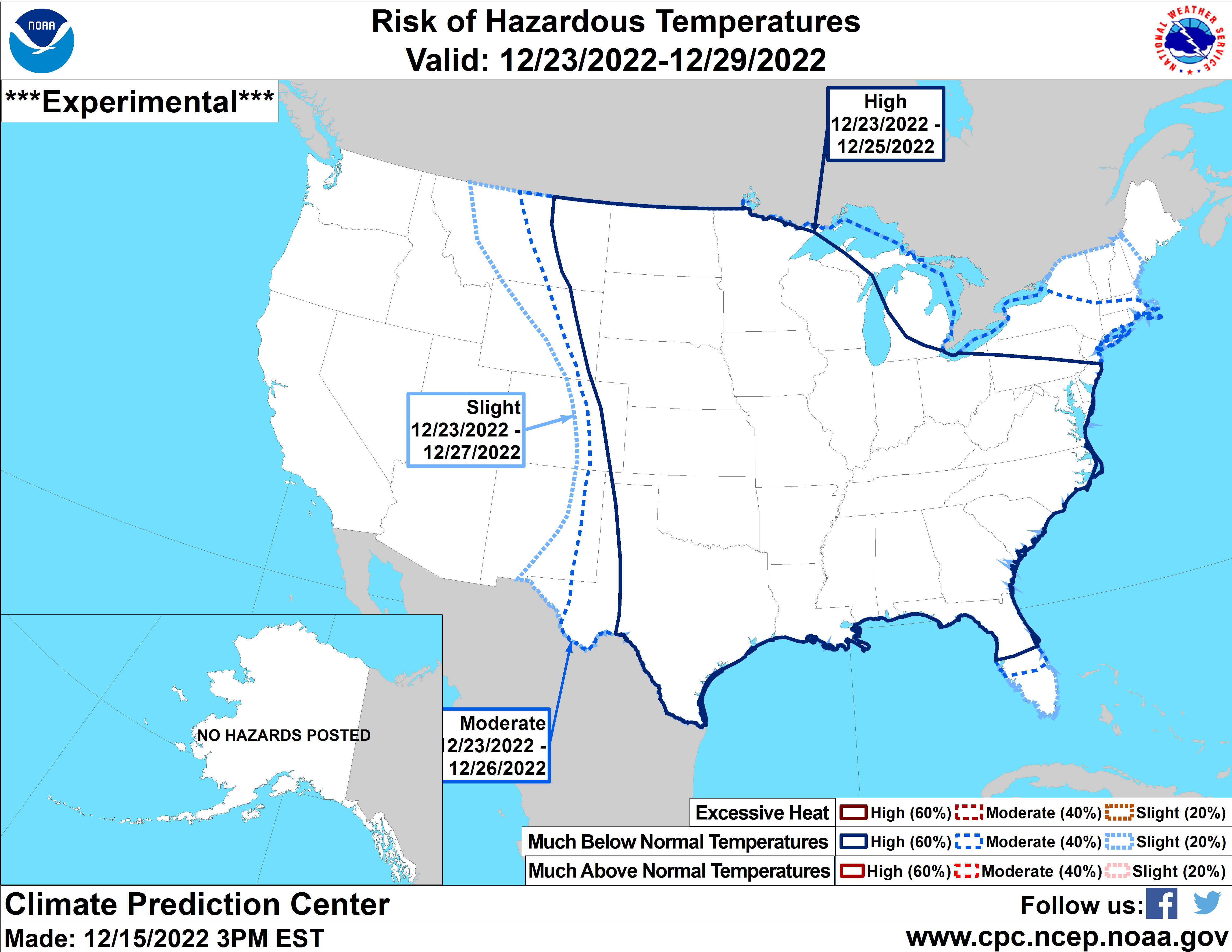
URGENT - WINTER WEATHER MESSAGE
National Weather Service Baltimore MD/Washington DC
255 PM EST Thu Dec 22 2022

MDZ503>506-VAZ036>040-050>053-502-506-230400-
/O.NEW.KLWX.WC.Y.0011.221223T2100Z-221224T1500Z/
Northwest Montgomery-Central and Southeast Montgomery-
Northwest Howard-Central and Southeast Howard-Nelson-Albemarle-
Greene-Madison-Rappahannock-Orange-Culpeper-
Prince William/Manassas/Manassas Park-Fairfax-Southern Fauquier-
Eastern Loudoun-
255 PM EST Thu Dec 22 2022

...WIND CHILL ADVISORY IN EFFECT FROM 4 PM FRIDAY TO 10 AM EST
SATURDAY...

* WHAT...Very cold wind chills expected. Wind chills as low as
  15 below zero.

* WHERE...Portions of central Maryland and central, northern and
  northwest Virginia.

* WHEN...From 4 PM Friday to 10 AM EST Saturday.

* IMPACTS...Strong winds could cause damage to trees and power
  lines. The cold wind chills could cause frostbite on exposed
  skin in as little as 10 minutes.

* ADDITIONAL DETAILS...For the Wind Chill Advisory, the highest
  wind speeds will be Friday into Friday evening. Affects from the
  extreme cold could be made worse due to power outages.

PRECAUTIONARY/PREPAREDNESS ACTIONS...

Use caution while traveling outside. Wear appropriate clothing, a
hat, and gloves.

&&

$$
-
Just now, Eskimo Joe said:
Wind Chill Advisory coming out for DC/Baltimore metros. Should populate on NWS website shortly.
Guidance has edged ever so slightly colder in the last 24 hours.
-
Models w/ 850mb temps between -22C(SE) and -25C(NW) across the region late Friday night/ predawn Saturday.
-
2 minutes ago, Terpeast said:
IAD dropped from 37 to 32 in the last hour, with a 22 dp.
The temp is bouncing at the moment.
-
1
-
-
IAD down to 19F this morning.
-
12 hours ago, mappy said:
awww shucks, thanks!
")
Hopefully you had a good anniversary today!
-
 1
1
-
-
3 minutes ago, DE2PA said:
Good Afternoon Mid-Atlantic forum. First time commenter, long time follower.
Allow me to introduce myself. My government name is Kyle. I am a 30yo Wilmington native and SE Pennsylvania transplant. I am an untrained weather enthusiast who has loved this science since I was a kid. Particularly the winter weather as most of us in here do. I was to be a Met major going into college but chose to join the military instead.
One way to describe my passion for this hobby is that I woke up this afternoon (working 3rd shift) and saw the full on cave of the 12z GFS. My wife must’ve thought someone in my family died because the look of defeat on my face was enough to cause her concern.
Anyway, happy to finally be in here amongst like minded individuals.
Relatable... minus the wife part.

Welcome aboard!
-
1
-
-
3 minutes ago, nj2va said:
Tracking shorts or sweats for New Years Eve?
The earlier the thaw, the earlier the reload!

-
 1
1
-
-
7 minutes ago, Kmlwx said:
Let's reactivate this thread for the late week system. Maybe we can reverse psychology it back to a snow event.
Imagine an H5 setup like this in the warm season lol.
We'd finally get back our long lost MOD risk day. TOR: 15%, WIND: 45%(hatched), HAIL: 5%
-
 1
1
-
-
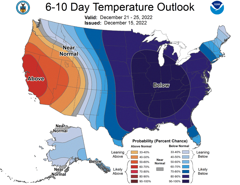
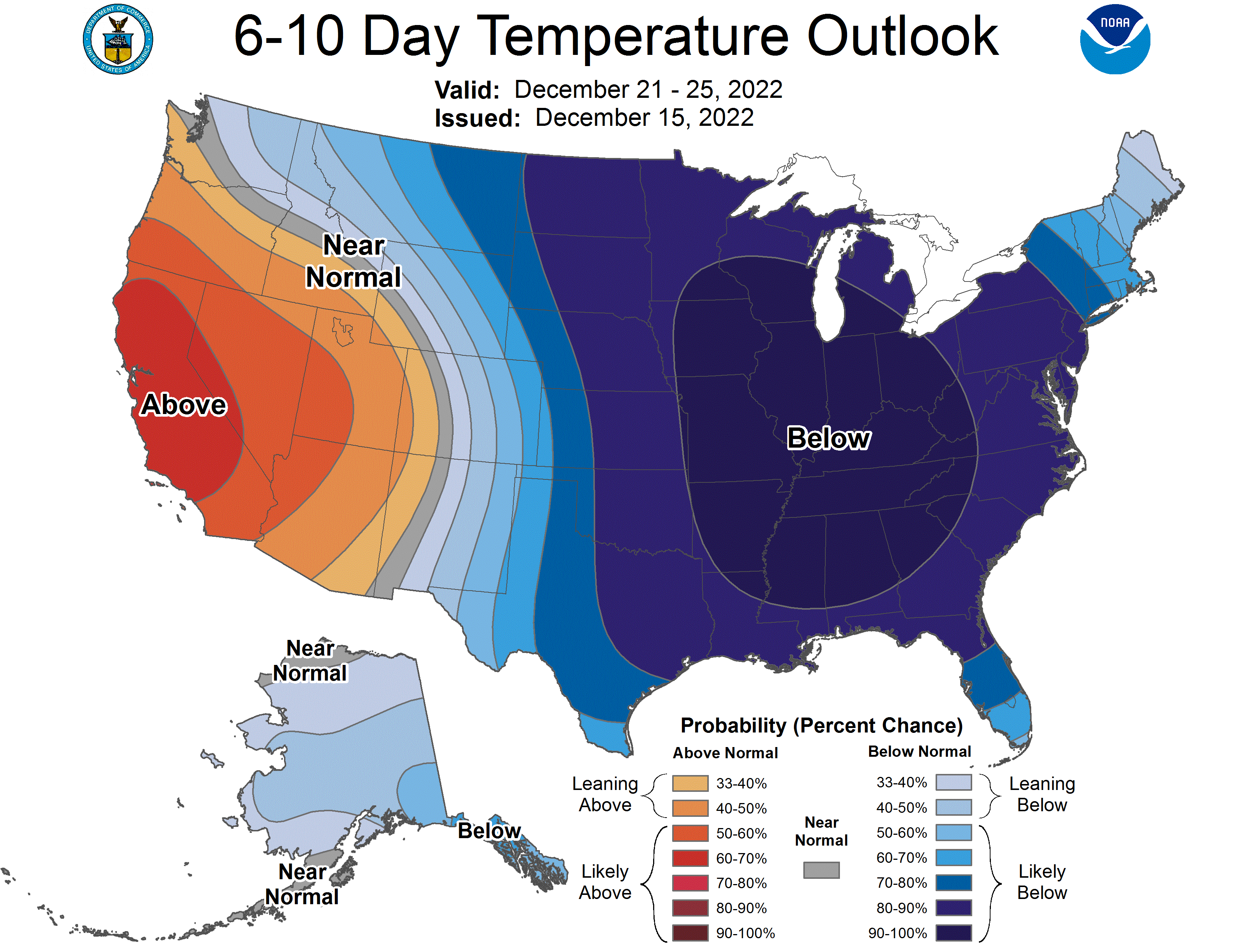
47 minutes ago, Terpeast said:
Kinda amazing to see the CPC put out a map like this.

-
1
-
-
Just now, WxWatcher007 said:
It’s even had some bad fails to get big heat too lately. Poor DCA.
2021 comes to mind. Weird peak temps across the main airports.
-
Just now, mappy said:
I don't think thats an issue. as long as it doesnt become a fight among people

-
1
-
-
33F rain > HECS
...
Carrot Cake > 33F rain
Down to 33F earlier with rain and a glorious jog in it.
#blessedindeed
Stay safe and enjoy your carrot cake today!
")
-
Down to 20F at IAD this morning. Currently 23F.
Could be a cold one with high clouds already overspreading the region that will slowly thicken throughout the day.
-
12 minutes ago, psuhoffman said:
There was an arctic front in the 80s that dropped 7” in an hour some places in northeast MD with thunderstorms. So anything is possible.
Yeap. January 25, 1985... The year that you're not too fond of.

-
4 minutes ago, psuhoffman said:
It is a very similar look. In 2009 eventually a piece of the TPV did drop in and phase while there was a 50/50 in the way to prevent a cutter. But keep in mind it took a while. We had a cutter and a sheared wave after that date before finally getting the win. Great setup doesn’t mean “next wave is definitely a big snow”. Even in our best patterns we often need multiple chances before we get a hit.
I've noticed that the data from CPC analogs apparently only goes through 2009. Do you or anyone in here know where can I find analogs from 2010 onwards?
-
14 minutes ago, CAPE said:
Wasn't that the year where it snowed for Thanksgiving(more SE of I-95), Dec was super cold, the Bay froze, then by mid Jan winter was over?
Affirmative.
-
1
-
-
Down to 21F at IAD this morning.
-
1
-
-
42 minutes ago, Always in Zugzwang said:
This sounds surprisingly similar to what actually happened on Feb. 14, 2015! Strong cold front blasted through, a couple hours burst of snow that dropped a quick ~2" where I'm at...followed by strong winds and very cold!
The event IS based off of the V-Day 2015 snow squall... but a weenier version of it during the daylight hours... and on everyones favorite day of seeing snow. So yes... you wouldn't be wrong to say it's similar to that event.

-
3
-
-
I think you all know what's now upon us.
December 22-23, 2022: Warm Rain to Arctic Chill
in Mid Atlantic
Posted
Just had a 20-30 second burst of heavy graupel that quickly coated the street in Herndon with that line... then it was back to lightish rain and a breeze. Those 20-30 seconds were neato though.