

George BM
-
Posts
2,610 -
Joined
-
Last visited
Content Type
Profiles
Blogs
Forums
American Weather
Media Demo
Store
Gallery
Posts posted by George BM
-
-
Assuming we don't go below 26F at IAD before midnight the high/low at IAD for today looks like:
48/26
Today's average at IAD:
47/27
+1/-1
Perfectly balanced... as all should be.
-
1 minute ago, Maestrobjwa said:
So on a technicality it wasn't really a clipper?
Not the classic kind that people are referring to with a 50-100 mile wide strip of light (sometimes mod+) snow oriented from west to east across the region associated with overrunning and/or a jet streak, no.
-
57 minutes ago, Maestrobjwa said:
Thought that was February that year? (I remember it happening on V-Day unless that was another one)
January 6, 2015 is the one I remember well. V-Day 2015 was everyones favorite snow squall(s) of recent times. Well the associated shortwave did enter the US from near Alberta but the strongest forcing by far came along the arctic front.
-
So IAD gusted up to 50kts(58mph) late last hour.
Winds: NW 33mph Gusts: 58mph for the 5pm obs there.
-
 1
1
-
-
URGENT - WEATHER MESSAGE
National Weather Service Baltimore MD/Washington DC
321 PM EST Fri Feb 17 2023

DCZ001-MDZ003>006-008-011-013-014-503>508-VAZ028-031-052>054-501-
505>508-WVZ051>053-180000-
/O.NEW.KLWX.WI.Y.0005.230217T2021Z-230218T0000Z/
District of Columbia-Washington-Frederick MD-Carroll-
Northern Baltimore-Cecil-Southern Baltimore-Prince Georges-
Anne Arundel-Northwest Montgomery-
Central and Southeast Montgomery-Northwest Howard-
Central and Southeast Howard-Northwest Harford-Southeast Harford-
Frederick VA-Clarke-Prince William/Manassas/Manassas Park-Fairfax-
Arlington/Falls Church/Alexandria-Northern Fauquier-
Western Loudoun-Eastern Loudoun-Northern Virginia Blue Ridge-
Central Virginia Blue Ridge-Morgan-Berkeley-Jefferson-
Including the cities of Washington, Hagerstown, Frederick,
Ballenger Creek, Eldersburg, Westminster, Reisterstown,
Cockeysville, Elkton, Baltimore, Bowie, Suitland-Silver Hill,
Clinton, College Park, Greenbelt, Laurel, Camp Springs,
Glen Burnie, Annapolis, Severn, South Gate, Severna Park, Arnold,
Odenton, Germantown, Damascus, Bethesda, Rockville, Gaithersburg,
Silver Spring, Lisbon, Columbia, Ellicott City, Jarrettsville,
Aberdeen, Winchester, Berryville, Dale City, Manassas,
Woodbridge, Lake Ridge, Montclair, Reston, Herndon, Annandale,
Centreville, Chantilly, McLean, Franconia, Arlington, Alexandria,
Falls Church, Warrenton, Purcellville, Leesburg, Ashburn,
Sterling, Big Meadows, Wintergreen, Paw Paw, Martinsburg,
Charles Town, and Shepherdstown
321 PM EST Fri Feb 17 2023

...WIND ADVISORY IN EFFECT UNTIL 7 PM EST THIS EVENING...

* WHAT...Northwest winds 20 to 35 mph with gusts up to 50 mph.

* WHERE...Northern and central Maryland, the Washington and
  Baltimore Metropolitan areas, northern Virginia,the Blue Ridge
  Mountains, and the eastern Panhandle of West Virginia.

* WHEN...Until 7 PM EST this evening.

* IMPACTS...Gusty winds could blow around unsecured objects. Tree
  limbs could be blown down and a few power outages may result.

PRECAUTIONARY/PREPAREDNESS ACTIONS...

Use extra caution when driving, especially if operating a high
profile vehicle. Secure outdoor objects.

&&

$$
-
11 minutes ago, Eskimo Joe said:
Sharp fropa in Gaithersburg.
Event of the year thus far...
-
 1
1
-
-
HRRR actually has 1km winds into the low 40s (kts) (~50 mph) tomorrow afternoon w/ CAA behind the front. Perhaps we get a Wind Advisory?
-
Still 65/41 at IAD at 8:29pm.
-
3 hours ago, Stormfly said:
We bust harder with wind then snow in these parts.
")
Severe wind...true.
Wind strong enough to be a nuisance but too weak to induce adrenaline... that's constant.
-
1
-
-
21 minutes ago, MN Transplant said:
Tickling 70 at IAD
Made it! Currently 70/43 at IAD.
-
Some decent digital wind for next Friday on todays 12z GFS.
-
1
-
-
1 hour ago, WxUSAF said:
Most solar production today since October 18. #sunangle
It's definitely becoming noticeable how much higher in the sky the sun is now at solar noon than it was in December.
-
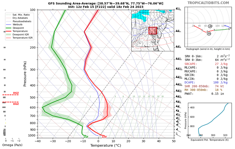
41 minutes ago, Terpeast said:
2.16” here in ashburn.
temps hung around 36-39 the whole time.
with a proper cold air in place and the same track, this would have been 20 inches.
But despite the cold surface temps, this wasn’t even close. Even if the surface was below freezing, it would have been ice given the airmass. >32 isotherm all the way up to 700mb.
So this was nowhere being close to a snowstorm without a 50/50 and a much, MUCH colder airmass.
Wow. Over twice as much as the 1.01" IAD recorded. The band must have set up just N and W of the airport over you.
-
PHL 58 - KC 37
-
1
-
-
11/15/2022: T (sleet)
12/10/2022: T (sleet)
12/22/2022: T (rain w/little SN/IP mixed in)
12/23/2022: T (30 sec graupel squall. The following hour... 5-10min SN/SN+)
1/08/2023: T (few sleet pellets)
1/22/2023: T (few sleet pellets at onset)
1/25/2023: T (rain/sleet mix)
2/01/2023: 0.5"
2/12/2023: T (light RA/IP)
Total as of February 12, 2023: 0.5"
-
4 minutes ago, MN Transplant said:
65.7 at 7:30pm on Feb. 9th. Yeah.
IAD holding at 69F.

-
3 hours ago, George BM said:
IAD has tied the record high of 69F set in 2001 today.
Currently 69/48 at IAD.
IAD managed to leap up to 71F in the 4pm hour breaking the daily record.
-
 1
1
-
-
IAD has tied the record high of 69F set in 2001 today.
Currently 69/48 at IAD.
-
Currently 50/21 at IAD. Mild.
-
Lookin' goooooooood!
")
-
4
-
-
11/15/2022: T (sleet)
12/10/2022: T (sleet)
12/22/2022: T (rain w/little SN/IP mixed in)
12/23/2022: T (30 sec graupel squall. The following hour... 5-10min SN/SN+)
1/08/2023: T (few sleet pellets)
1/22/2023: T (few sleet pellets at onset)
1/25/2023: T (rain/sleet mix)
2/01/2023: 0.5"
Total as of February 1, 2023: 0.5"
-
Woke up this morning. Don't believe what I saw! Hundred billion snowflakes piled up on earth's floor! I'd never know it being asleep. Hundred billion fallen away searching for a surface!
-
3
-
1
-
-
Woke up and recorded 0.5" here. Herndon, VA.
-
5
-
-
Starting out cold, dreary and with a little bit of white?
February Discobs 2023
in Mid Atlantic
Posted
Another very gusty afternoon it looks like coming up this Tuesday w/ steep 0-2km LRs and 1-2km winds into the 40s(kts)... at least on the HRRR. Got to imagine that other CAMs are fairly similar.