Geoboy645
-
Posts
703 -
Joined
-
Last visited
Content Type
Profiles
Blogs
Forums
American Weather
Media Demo
Store
Gallery
Everything posted by Geoboy645
-

Nov 28-30th Post Turkey Day Winter Storm
Geoboy645 replied to Chicago Storm's topic in Lakes/Ohio Valley
Correct. In fact, from what I can tell this might be the first double digit storm before January 1st since the second storm of the December 2016 sequence, if not 12/20/12. Which is insane to say the least. -
Nov 28-30th Post Turkey Day Winter Storm
Geoboy645 replied to Chicago Storm's topic in Lakes/Ohio Valley
Definitely looks like the potential for a significant hit for the Madison metro is steadily increasing over the last day or so. Could get very interesting here, especially because we are potentially less than three days out from the snow starting to fall on Thanksgiving weekend, with all that entails for travel. Could see headlines and messaging start in earnest tomorrow because of this factor. -
Yeah this could be a sneakily impactful wind event given it's the day before Thanksgiving and all. Could affect both air and road travel.
-
Hard to believe at this time last week we were talking about feet of snow falling in areas that are now over 70 degrees. Got to love November in the Midwest.
-
With the issuing of WSW's for Chicago and the N IN lake effect belts, I figured that this event has become thread-worthy. The main storm system isn't that notable, with the warm ground leading to at most an inch or two of accumulation for some higher terrain areas away from the lake. However, after the main system passes through we could have a significant lake effect event for so early in the year, especially on Sunday night into Monday. LOT and IWX have highlighted for the potential of at least several inches of snow wherever a main band sets up for any length of time. Combined with wind and the fact that leaves are still on the trees from the previously very warm autumn, this could be a potentially significant early-season event. Especially considering the possibility that one of the bands may set up into downtown Chicago and points south of the city, and the fact that this really has only become a thing within the last 24 hours.
-
Fortunately there are several indications that we are about to end up in a much more active pattern potentially starting next week. And with a still well-above average Gulf, could get interesting here for storms. The fact that, unless something stupid happens, we are going to have a Gulf like that with no TCs to cool it down before storm season kicks up is going to make things interesting for moisture availability the next couple months imo.
-
Yeah no complaints about the forecast for the next week. Consistent upper 60s and sunny, the perfect October combo. Much better than the June in October weather of last week. And with a hint of a more active storm pattern incoming for the second half of the month for those who are going to go "but it's so boring!"
-
I guess we are doing June in October again. This could be forecast for the week of Father's Day or the 4th. Not so much for October 1st. At least the days are nice though. Just to think, we have the same daylight as ~March 10th rn, where we can have a foot of snow on the ground and 20 degree highs.
-
Drought monitor is starting to look pretty rough to the S and E of the forum. Widespread D1 with pockets of D2 and even an area of D3 (!) in OH and S IL.
-
The next week+ looks like almost an exact repeat of last September's consecutive 80s streak, with maybe just slightly less intensity. Will be interesting to see how many consecutive 80s we have, which after today's date is more and more impressive the later we get into the month. And how much we recover the anomalies for the month. We bottomed out around -9 a couple days ago, so we'll see if we get close to or above average for anomalies after this stretch.
-
Looks to be a very cool start to the month for the entire region. Some very impressive cold anomalies showing up for later next week considering the time of year and how far out this is. Definitely a difference from the last couple of Septembers where we were in the 80s and 90s well into the month.
-
Summer 2025 Medium/Long Range Discussion
Geoboy645 replied to Chicago Storm's topic in Lakes/Ohio Valley
Woah, I did not realize it has been that dry down there this month. -
Yeah I'd be alright with this weather for the next 6 weeks, with the occasional rain chance so we don't dry out.
-
It's been a couple years since we have had our late August first cool wave. Definitely will feel nice (smoke not withstanding) after this humid summer.
-
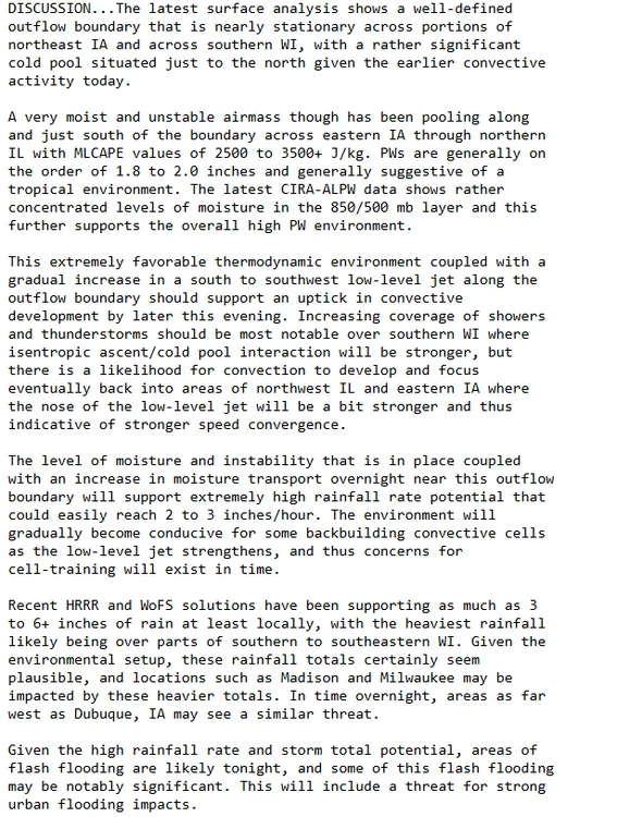
Yeah MKX is really highlighting the potential for multiple rounds of rainfall pretty much every night from tonight through Tuesday next week, depending on where the mesoscale boundaries and such line up. This could get interesting fast around here, as thanks to last weeks rain we can't really tank a couple inches of rain again. And anything E of the Rock would be a huge concern given all the flooding in Milwaukee and fact that the rivers have mostly just fallen out of flood stage. These types of events with a stationary boundary sitting across the state have really hurt in the past (2018,2007). Hopefully it will not be to that level at all, but considering what happened lsat week I'm not all that confident to say the least.
-
It is going to be a long night for S WI for rain/flooding. Already a rare FFW out for Milwaukee and West Allis (On State Fair weekend no less!) with 2.5"+ hrly totals. And WPC just put out a pretty strongly worded MPD for the area.
-
Yeah I'm definitely worried for some potentially significant flooding somewhere in S or SW WI. While it hasn't been as wet as most of IA over the last 30 days, it's still been wet enough to cause concerns even without some of the more extreme totals that models have put out. SW to NE is a bad direction for precip maxes in regards to the drainage network in this part of the state. And 6-10 inches of rain in a night would be very bad news for really any drainage around here.
-
It always amazes me how much of a difference there is for # of 90s pretty much every year between Chicago and Madison. Madison is only at 8 for 90s so far this year. Obviously the UHI is a major part of that, but still such a stark difference over only ~85 miles in latitude.
-
Huh, I did not realize the SPC outlook for 8/18/05 looked like that. Crazy it has been 20 years since then. I was too young to remember it personally though. I can't and frankly don't even want to imagine what it will be like when we get another Stoughton or Oakfield level tornado in the Madison area, and we have had a couple close call setups where that would have been possible the last few years.
-
It isn't so much a weakness per se as the edge of a ridge of high pressure. We have been in some variation of a ridge riding pattern for over a month now with only a couple brief exceptions. In this case, the last few days the MS Delta has been absolutely baking underneath a heatwave, and that ridge has flexed in such a way that as of rn its aligned with the I70 corridor. Hence the repeated flooding experienced in those locations the last few days. And overall it has just been a wet month for most areas E of the Rockies as this ridge of high pressure flexes and moves. With the extra moisture from yet another broiling Gulf of Mexico, it has led to a lot of rainfall along the edge of the ridge, and is the reason why it has been so humid even if the temps haven't been so extreme this month here in the Midwest.
-
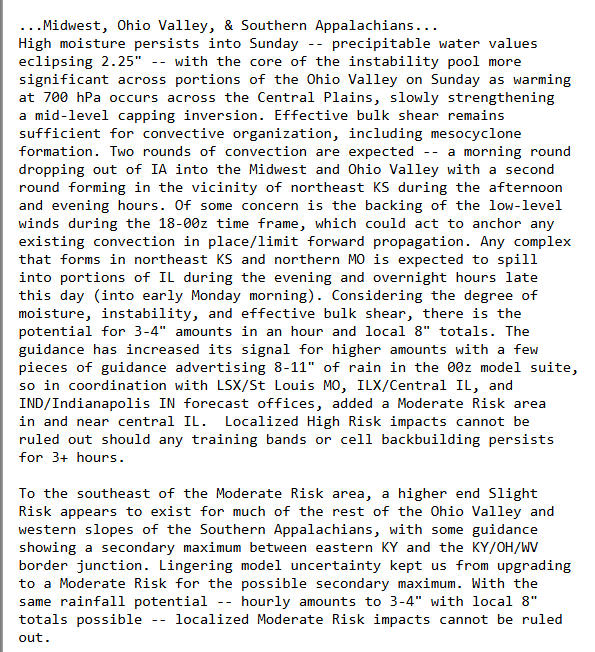
Guess I'll just put this in here, but there's a WPC MDT today for central IL. And the forecast discussion for it is pretty strongly worded. 8-11" of rain is not a small amount of rain to say the least. I don't think there are going to be any drought concerns wherever the precip max sets up after this...

-
Summer 2025 Medium/Long Range Discussion
Geoboy645 replied to Chicago Storm's topic in Lakes/Ohio Valley
Well, looks like after Monday the ridge will move east and then stall, setting up a ring of fire pattern for potentially the rest of the week next week. There are some differences as to where the exact stationary front sets up, however whatever areas that do end up underneath the ring could experience repeated rounds of heavy rain and potential flooding. These setups where there is a large ridge stalled on the E coast and a wide open GOM have caused major flood events in the past, such as a year ago when MN/IA/WI flooded while Detroit and points E experienced several days in the 90s. Definitely something to keep an eye on as we move into next week. -
The forecast has really zeroed in on a potentially quite significant heat wave for most of the subforum starting tomorrow and going through at least the weekend. At least 3-4 days of mid 90s over mid 70s dew points is going to cause heat index values to rise over 100 degrees over the weekend, especially in the Chicago and Detroit UHI's. While at this juncture it doesn't look like record highs are in jeopardy, the heat index and warm nights could cause some issues in the metro areas. This will probably be the most significant heatwave since the 2 day heatwave back in August 23. Figured that this is significant enough to warrant a thread of it's own. Edit: As I was typing this out, ARX just put out an Extreme Heat Watch. With heat indexes up to 105 mentioned over the weekend.
-
Over the last day or so, the Models have really zeroed in on a potentially major severe weather outbreak across the sub forum. Figured that there should be a thread for it considering it's only 4-5 days out.
-
Today felt like a May or June day, not late March. Waking up to morning t-storms that ended about 9. Cleared out and became sunny and warm. And then sunset, with distant anvils and occasional flashes of lightning. All it was missing was the greenery that comes with that time of year. Pretty cool though.