tunafish
-
Posts
2,269 -
Joined
-
Last visited
Content Type
Profiles
Blogs
Forums
American Weather
Media Demo
Store
Gallery
Everything posted by tunafish
-
 Ah yes. Enough wind to topple trees but not even budge the patio furniture. Dummy.
 -
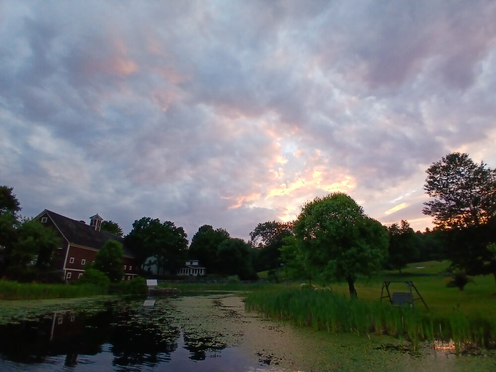
Dodging drops in Henniker (NH) at sunset.
-
I was about to give you a hard time for being so triggered over these clowns, but then here I am ready to Will Smith the next person I hear say "heat lightning".
-
He seems like the guy who counts driving his truck and walking inside from a parking lot as "working outside".
-
Didn't expect anything to pop off this far east without warning. Must be the outflow from Sebago hitting thr marine air. Lightning scared the shit out of me while I was taking an outdoor shower.

-
Great production. It took me like 28 days of bluebird August 2025 to hit 2MWh in a month. How much does the pool filter add to your consumption?
-
Severe storm moving through Augusta 50 miles away from Scarborough beach.
.thumb.jpg.c4a598100bcba70e87a2f08ce5d79a4c.jpg)
-
Good cloud action before sunset. Towers from storms about 35 miles west of PWM, with some fog bank rolling in.
.thumb.jpg.952ad60f4a936fc6e377d40bf4a59fb8.jpg)
-

-
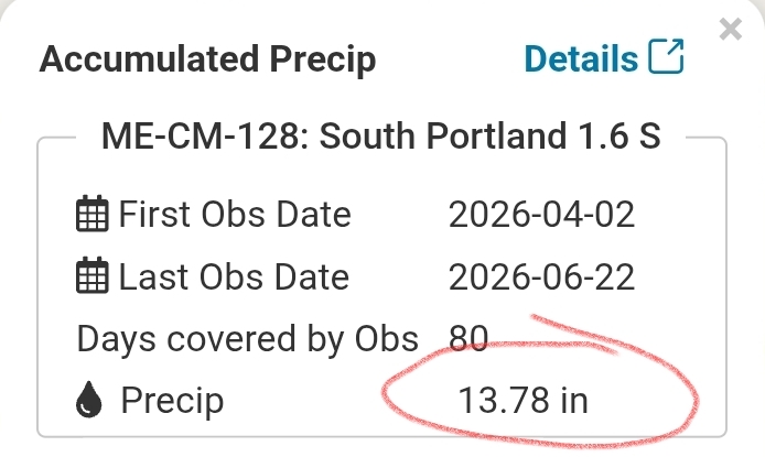
2.52" yesterday 5.18" MTD 16.30" since 4/1
-
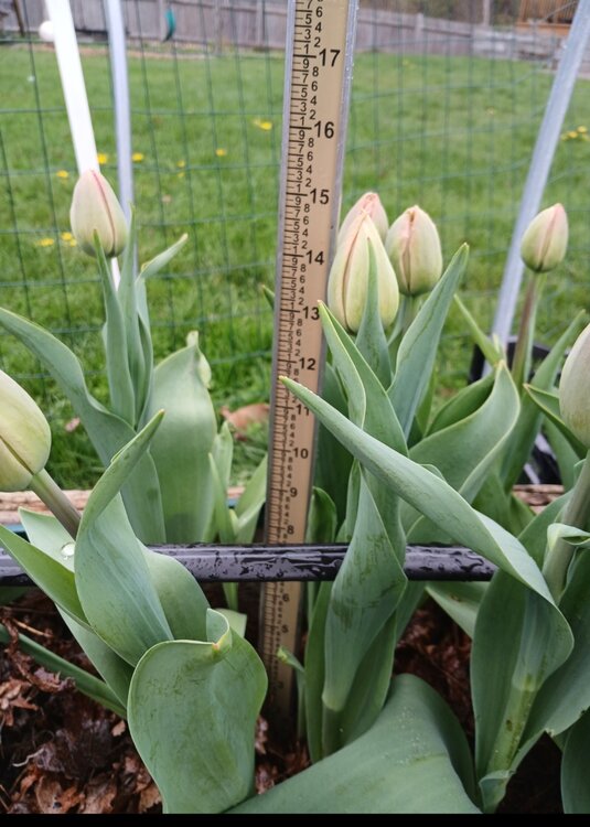
Well, if we're having a rain stick measuring contest, I'll whip mine out.
-
Lol wtf happened 1.93" overnight
-
Before seeing this sort of stuff, and like that car interior last year, I never really appreciated not having them here. What a menace.
-
If you use that true color overlay and go earlier in the day, I swear you can see waves pulsating over the northeast/rust/mid atl. Might have to zoom way in. Yes, I'm sober.
-
The biggest problem I see, around here at least, is how well-intentioned homeowners unintentionally spread it. They cut it, bag it, and bring it to municipal compost sites, where viable fragments can get redistributed. Even mowing, cutting, or moving plant material can spread it if stem or rhizome fragments survive and easily reestablish.
-
When you figure out how to convince your wife that this is the correct time to go down south, please let us know. Counting on you!
-
Thirty-eight point seven First 30s in ten whole days Outdoor shower time
-
"Our MDW rate is $349 per night, but we're running a special right now - for an extra $10/night^ you get full access* to our famous Snow Garden**. ^ per guest * dawn to dusk ** "Garden" for the dirt. Stowe Resorts LLC is not responsible for any lost or damaged property including personal injury.
-
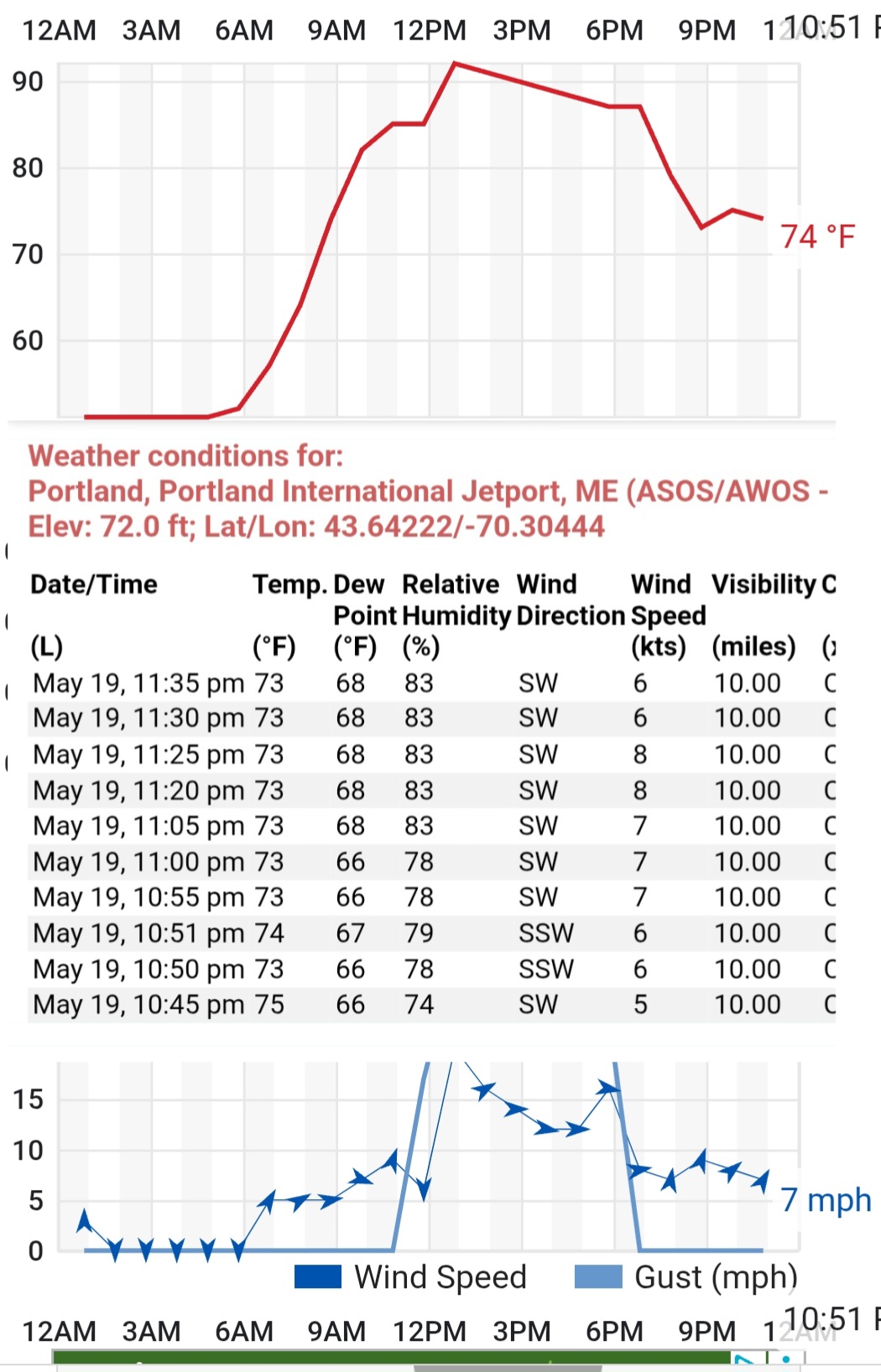
73/68 at midnight in PWM is rare even in peak climo. Wind just needs to go calm and it'll drop some.

-
I know it feels like 90% of connective storms fizzle by the time they reach the coast, but I don't think that's a new thing, or that it's gotten worse in recent years. Missing 0.20" on a single cell a dozen times a year isn't going to make that much of a difference, I don't think. But your overall point is clearly accurate - the coastal has experienced more dry conditions than most places in the state.
-
2.40" First time >2" (by 7a-7p CoCoRAHS obs) in over 2 years.
-
https://share.google/VVybP5QhM4G3FDJbv Source: NOAA National Centers for Environmental Information (NCEI) (.gov) https://share.google/VVybP5QhM4G3FDJbv
-
If you dont want to look at them for another 2 weeks (as flowering winds down), pull them with one of those extendable tools. Like $30 on Amazon. Next year hit them with pre-emergent (corn gluten) like the 2nd week of April, then the 1st week of May. It'll take care of that other grass, too. It's remarkably effective. Putting any synthetic fertilizer or herbicide that close to water is about the worst thing you could do. And it won't do anything for your current situation, either.
-
We bloom, we use snow messurement tools before harvest, and we arrange. Oh and we always dandy.


.jpg.3f6f02df1fbea90af81824d597c8e1d1.jpg)
.jpg.c0c13a148c0b78f6925fdec13d8a3ab4.jpg)