Cobalt
-
Posts
5,218 -
Joined
-
Last visited
Content Type
Profiles
Blogs
Forums
American Weather
Media Demo
Store
Gallery
Everything posted by Cobalt
-
Seems like the EPS Control followed this line of thinking.. although it cuts the primary into Indiana lol. FWIW still a healthy signal during that time on the main ensemble. .
-
EPS looks practically identical to the GEFS through around day 12 (some minor differences from days 7-10). Quite the model agreement there, wow.
-
The discussion about how that storm would've panned out if it had happened a month prior is quite interesting. I remember the DC area wasted most of the WAA precip as rain, then a fair bit more precip during the day of the 21st when rates lightened up near noon. A redux during the prime of winter would certainly make many here happy.
-
The axis of cold air intrusion looks rather similar to the 1959-60/2005-06 composite GIF that HM posted on his twitter a few days ago Both post-SSW, both similar Ninas (at least 05-06 and this year, that is).. You can see the similarities to the airmasses below. I see what you did there though
-
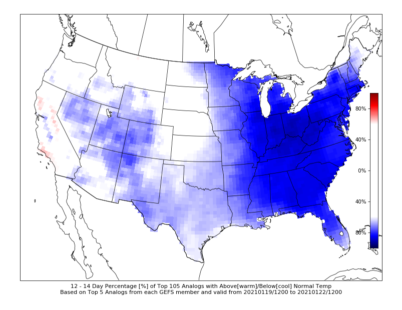
For those who wanted a truly cold airmass, here you go.. quite the signal for cold across North America this far out
-
I feel like out of any time, we'd need this the most now. Make yourselves comfortable, and perhaps we can go 3 for 3? Keep the good mojo inside the building at all times, please.
-
Here’s 12z for reference. Haven’t seen 18z yet, but this is a pretty cold airmass, albeit centered to the west of us. Not at torcherrific at least?? .
-
I think this was mentioned either last winter or in 17-18 by PSU, but don’t bad/crappy winters group into 3 or 4 year stretches? I hope this is just a case where a bad stretch is enhanced by warming baseline temps, but that’s probably the optimist way of looking at it :/ .
-
Seems like a tiny bleed to the GEFS actually. Not as good of a look as we were seeing on the 12z EPS or 12z GEFS yesterday, but lower heights with the SER. 850s anomaly shows that cold air, and as PSU stated, that -NAO might be what it takes to combat the trough setting up in the west .
-
Quite the costal signal during that time too. Precip/snowfall means responding quite favorably.
-
That 360hr look lol, primary up in Illinois and we’ve got blue over most of the sub forum. We seem to have flipped from the GFS showing anything but snow over us but of course it will change in just 6 hours .
-
18z EPS has a small cluster of those lows off the shore on Thursday (12z EPS had a few but not as many) . I guess considering that if that followup wave happens, it's 6 days out now, but wouldn't the great lake low ruin the party?? The control also had this, which seems pretty close to something other than a nonevent.
-
It seems like a combination of bad luck + us jumping the gun. From Jan 1st we had known that the best chance of snow would be Jan 15-25 onwards, but a few favorable model runs speeding up the breakdown of the negative PNA had us looking for some gravy before our main window arrived. Some of those looks produced pretty snow means, mainly for the events on the 8th and 12th. Considering those storms as well as the one on the 3rd, it's somewhat clear to see why we've been effectively shutout. Those have all been rather weak waves that struggled to produce much precip or to struggled to pull in any cold air. The 3rd is a decent example of this, and even there it gave upstate PA a modest snowfall while we got a pitiful initial wave of light rain. The 8th was rather suppressed in the medium range, but some runs showed the route in which we could've scored there. Even as you mentioned, without a moderate temp gradient the precip shield was anemic at best and that threat went right out the window. As for Jan 12th that's still TBD, but yet another weak wave won't amount to much for us as currently modeled. Outside of the 8th and 12th threats on the super early Jan ensembles, most members still pasted our region with +5-10 temp departures in 850s and in surface temps through mid month. With weak precipitation that's not gonna do much in the way of snowfall in our general region. Part of me looks at NC and Texas getting decent snow as proof that we're simply dealing with wrong place and wrong time, but who knows. We've certainly punted great patterns before, and in a moderate Nina it seems fitting. Hope our mid/late Jan luck is better, and hopefully if the SE ridge does try to flex itself in, we can wiggle our way to the positive side of the snow gradient.
-
0z Euro seems to have that slowed down wave idea.. weak/no precip through Tuesday but the secondary wave of precip gets to just south of our area near 0z Wednesday.. not much in the form of anything, but it's quite the trend considering that the 12z run had no precip during that time. Perhaps this is what we want?
-
Seems like we're better off banking on the wave slowing rather than speeding up.. seems like models tend to slow down storms anywho. Wasn't that what happened with the Dec 16/17th storm, where the slowdown allowed the 50/50 low to ease to the east somewhat?
-
Eh, I wouldn't say exactly that. The probability tool is actually pretty useful here. With the 0z runs there was a fair bit more consensus with getting snowfall into our area, generally 30-50% of ensemble members in our general subforum area gave us 1" or more, compared to ~20-40% this run. Probably a big hitter or two skewing the mean here.
-
Fortunately (or unfortunately), we're not the only ones in snow anguish it seems. Out in Jackson Hole for the week and according to some avid skiers, aside from out near British Columbia, there isn't much snow at the big resorts in the Rockies. Park City is managing with a ~20" base depth and they got saved by 10 inches of snow two days ago. Doesn't seem to be much help there in the near future. Maybe we're just in the wrong hemisphere?
-
I've seen worse snow means?
-
I might be going out on a limb here, but it seems like to combat the increase in temps, we need our PAC look to be substantially better than it used to. That's what made our rather frequent events in 13/14 and 14/15 work out pretty well. I mentioned this in the banter thread, but that necessity has to undoubtedly hurt us in Ninas, since for any high end WWA or WSW events (as pointed out by PSU) they require the favorable Atlantic to be our main lifeline to pull off those events. Yet if the pacific needs to be perfect to prevent a warm/wet and cold/dry regime, we're essentially dancing between both the PAC and Atlantic teleconnections. Like I said, I'm probably going out on a limb, but that's the main way I can see how most of our Ninos in the past decade have been near or above climo, while we've punted numerous good patterns in recent Ninas.
-
Thermals holding on through 132 but it's close. A decent thump of snow, considerable improvement compared to 12z
-
That's the GEFS, unless you're comparing that to the EPS.
-
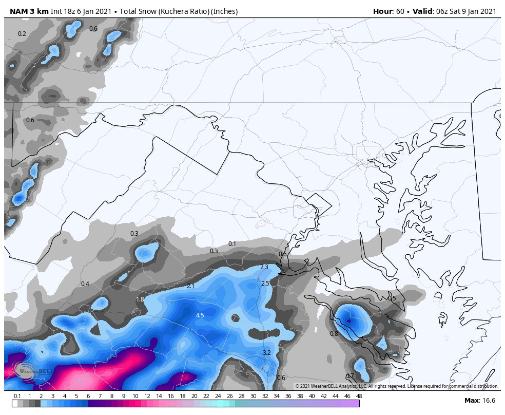
I've seen worse trends at 60hrs out?? Congrats SW Virginia though, reminds me of a certain storm a few years back... Correct me if I'm wrong, but it seems like we tend to have these stretches more frequently in Ninas? Even if the pattern is comparable, it just seems like with increasingly marginal temps, any sheared or weak wave of precip that we get just has no effect. Our Nino in 18-19 had a few nickel and dime events IMBY, and from mid Jan through early March I recorded 6 events ranging from .4" to 2.1" (This is of course not including the 4 inches MBY got from the Feb 20th storm). That pattern was certainly not what we'd call perfect during that time, but there was still a respectable amount of snow events. Perhaps it's recency bias, but it certainly does seem like the gap between Nina and Nino winters is growing with our temp gradient increasing over the years.

-
Would comply with the Jan 15-20 idea. The main takeaway from that Euro is the pure rapid-fire nature of shortwaves, just gonna need some luck and timing to make one work.
-
0z Euro is certainly more suppressed, not a cave to the GFS, but quite the shift.. although the interesting thing is that the storm gains latitude earlier than it's 0z counterpart, near the Louisiana coast rather than over Tallahassee. 18z EPS did the same IIRC, so perhaps that's our ticket to getting the storm up here?
-
0z Euro for the late week threat, FWIW. Here’s the 12z Euro at the same time. A bit wonky in precip, but a definite jump North with the lp .