

Cobalt
-
Posts
5,216 -
Joined
-
Last visited
Content Type
Profiles
Blogs
Forums
American Weather
Media Demo
Store
Gallery
Everything posted by Cobalt
-

Feb Long Range Discussion (Day 3 and beyond) - MERGED
Cobalt replied to WinterWxLuvr's topic in Mid Atlantic
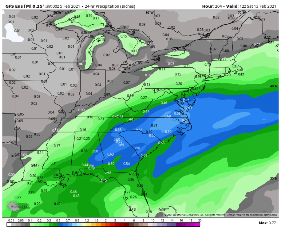
Pulling this from the day 3-7 thread but yeah the EPS looks super promising for that timeframe. I guess it depends on where the boundary sets up but with cold out in front it looks pretty favorable for at least a frozen event somewhere in our area. I'll take this precip mean from that lead and let all the events we have lined up distract until that timeframe, but it's hard not to like the signal for that. Snow mean looks pretty too, but obviously not worth posting this far out lol -
Feb Long Range Discussion (Day 3 and beyond) - MERGED
Cobalt replied to WinterWxLuvr's topic in Mid Atlantic
Yeah, there's a decent difference compared to the 0z Euro wrt how the PV lobe presses down on the Central/Western US. It's a fair bit more east compared to 0z, and it's also more elongated (which I'm not sure if that had any effects with the ridge or surface depiction for us, but some of the more slightly strung out solutions for that had less of a ridge pump up so I'd imagine it's a positive). Good trends that were pointed out by the 6z EPS too. Would love to see that continue, but the ensembles haven't handled the PV aspect well.. at all. -
Feb Long Range Discussion (Day 3 and beyond) - MERGED
Cobalt replied to WinterWxLuvr's topic in Mid Atlantic
Judging by the temp/snowfall means during this period, this might not be a bad thing depending on how much Arctic air from the PV lobe filters into our area beforehand. Seems like a fair bit of solutions try to get a storm to bully through some cold air that's already made it's way into the East at around D10-12. Clear CAD signal on the 0z EPS because of that too. Might be what it takes to avoid cold/dry. -
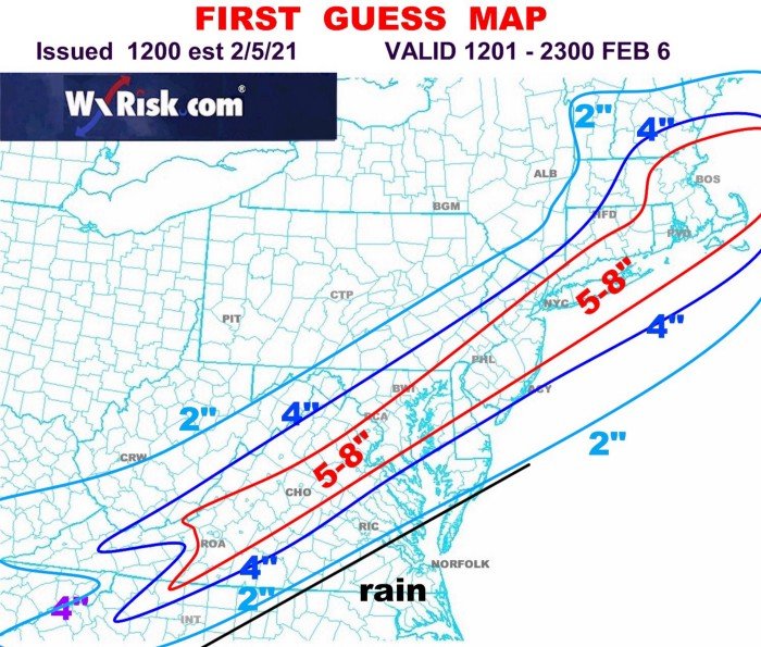
DT's first guess map should make a fair bit of people happy.
-
Hah great idea until a weenie on tilt goes out of their way to make 4 different accounts just to lock someone out
-
Feb Long Range Discussion (Day 3 and beyond) - MERGED
Cobalt replied to WinterWxLuvr's topic in Mid Atlantic
At the very least it seems like we're going to get a decent feed of moisture coming through our area next week, snow, ice, or otherwise. Fun times ahead! -
Feb Long Range Discussion (Day 3 and beyond) - MERGED
Cobalt replied to WinterWxLuvr's topic in Mid Atlantic
Thanks @MillvilleWx and @HighStakes I appreciate it a lot. A lot of it is due to excellent posters such as yourselves. I've learned a lot in just the past year alone, and it feels like the field of knowledge in meteorology is virtually endless (which is a good thing, of course!) Anywho, the EPS looks like it moved to what the OP was suggesting, but as I felt it would be, it's not as extreme, and looks similar to the GEFS in how the PV lobe is consolidated and also how it's located. Seems like that location strikes the perfect balance because that's an absolute firehose of precipitation trailing up with the overrunning. The PV is also right on it's heels, so anything that falls would stay around. In fact the mean trended colder for that period around 180hrs onwards, so probably some absolutely frigid members in there following the overrunning event. -
Feb Long Range Discussion (Day 3 and beyond) - MERGED
Cobalt replied to WinterWxLuvr's topic in Mid Atlantic
The GEFS looks a lot better in that regard, in fact it improved compared to 6z. Hoping Euro jumped to one extreme and that the EPS isn't directly in that camp, but even with it's attempts to pump up a massive ridge the output was still pretty wild. Last time we were in a overrunning scenario like this I recall a lot of concern of energy being dumped into the western US but we ended up with suppression depression, doesn't seem like this will go that way though. -
Canadian looks to be a pretty substantial hit FWIW
-
Feb Long Range Discussion (Day 3 and beyond) - MERGED
Cobalt replied to WinterWxLuvr's topic in Mid Atlantic
GEFS is in that camp it seems. For the past 2-3 runs it's wanted to hold onto the PV being a fair bit west and pumping up the ridge to the east. Even then it's not as extreme as the op, and quite frankly a blend between the GEFS and the EPS would look pretty sweet wrt the overrunning event. GEFS is on the wet/warmer end (still some nice hits in there), EPS is on the colder and drier side. -
Remember that there's 2 NAMs and follow Bob Chill's rule about the best model to follow in times like these but yeah that relaxation to the SE can stop for sure lol. I'll hug the 3k/Ukie/EPS combo for now ig
-
Day 3-7, February 7 threat, Day 7+. Lot of sevens, I don't blame him.
-
Feb Long Range Discussion (Day 3 and beyond) - MERGED
Cobalt replied to WinterWxLuvr's topic in Mid Atlantic
Uh.. for a day 7 signal.. woof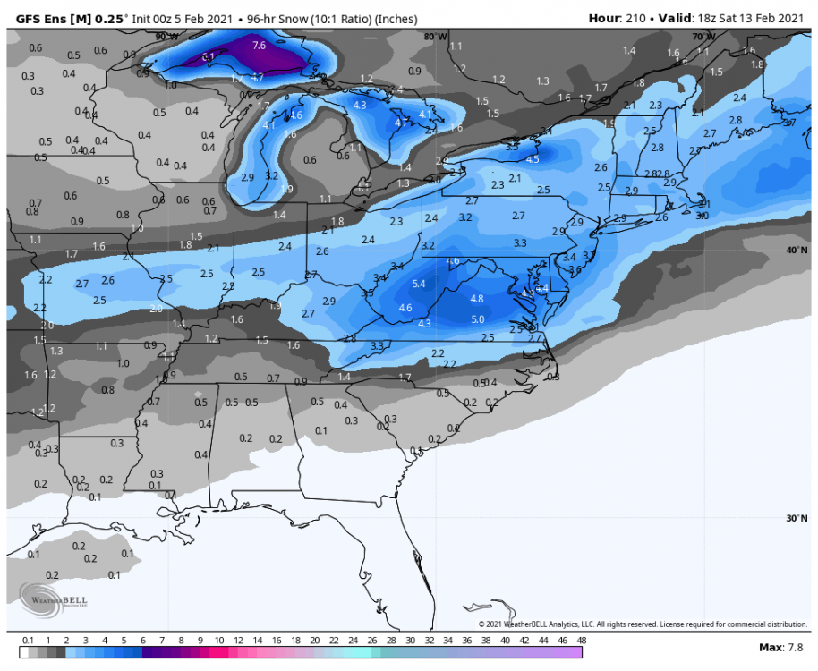
-
Feb Long Range Discussion (Day 3 and beyond) - MERGED
Cobalt replied to WinterWxLuvr's topic in Mid Atlantic
Wasn't that 2017? I just remember it coinciding with the Arctic blast and also my weenie self coming off of willing that December 9 storm northwest (and continuously posting those absurd GFS outptus) -
Not sure about that, check out the 1hr snowfall rates lol. Also the 3k pushes the 850 boundary even farther north, honestly was looking like it was gonna get close to mixing, but not sure we could complain after 1-2"/hr rates for 3+ hours and then thumping sleet lol. PSU mentioned this in the 3-7 day chat but this feels similar to Feb 17 2018.. marginal temps surrounding the event and it looked super good for us at the day 3-4 range (but it jogged on North and we got lucky with good rates for a bit). Although all guidance considered we're probably in a good spot, still some misses to balance out the NW solutions
-
Feb Long Range Discussion (Day 3 and beyond) - MERGED
Cobalt replied to WinterWxLuvr's topic in Mid Atlantic
Luckily it seems like the Euro is certainly the slowest out of the models showing a hit. Will have to see if the progression speeds up since that certainly detriments the snow totals for the metro in the run. -
Feb Long Range Discussion (Day 3 and beyond) - MERGED
Cobalt replied to WinterWxLuvr's topic in Mid Atlantic
Euro is actually somewhat slower than the NAM FWIW. It's just by like 6-12hrs, but obviously given the temp constraints it's huge since it has mod/heavy snow falling near noon compared to when the NAM has it. -
Feb Long Range Discussion (Day 3 and beyond) - MERGED
Cobalt replied to WinterWxLuvr's topic in Mid Atlantic
CMC is a bit NW too. Seems like the bleeding southeast has eased a bit, but at least we're not out of the game based on guidance being somewhat close. -
Feb Long Range Discussion (Day 3 and beyond) - MERGED
Cobalt replied to WinterWxLuvr's topic in Mid Atlantic
Ukie is a decent hit, super thin 3-6" stripe just like what the Euro drops on us. Really similar solution in fact. -
Feb Long Range Discussion (Day 3 and beyond) - MERGED
Cobalt replied to WinterWxLuvr's topic in Mid Atlantic
Improved cluster! Seems like the GEFS is in the ICON/Euro/EPS camp. Canadian politely declined joining for the 0z suite, not without apologizing of course.
-
Feb Long Range Discussion (Day 3 and beyond) - MERGED
Cobalt replied to WinterWxLuvr's topic in Mid Atlantic
GEFS looks quite improved for the weekend threat. Almost in line with the EPS in both precip and snow mean. Waiting for additional panels to come out such as lp locations. -
Feb Long Range Discussion (Day 3 and beyond) - MERGED
Cobalt replied to WinterWxLuvr's topic in Mid Atlantic
To hit our region? Maybe Feb 12-14 2014?? At least I think but it couldve been hybrid. -
Feb Long Range Discussion (Day 3 and beyond) - MERGED
Cobalt replied to WinterWxLuvr's topic in Mid Atlantic
That's what I was thinking. Certainly not frigid for us but there's still cold air to tap, basically right nearby. Of course we'd be playing with fire, but it could boast well. -
Jan 31st - 33rd Storm Obs and Disco like it's 1979
Cobalt replied to Bob Chill's topic in Mid Atlantic
1.5" on the board as of 10:15am to put the storm total at 5.1" here in McLean!! Despite the big dog potential on this storm, for a Miller B (hybrid?) it's been pretty exceptional. Not often can you have snow falling for 3 days constantly re-whitening surfaces off and on like this. Still light snow now so hopefully that total can be added on to a bit, but this 2nd half of the storm has certainly exceeded my expectations


