

Cobalt
-
Posts
5,216 -
Joined
-
Last visited
Content Type
Profiles
Blogs
Forums
American Weather
Media Demo
Store
Gallery
Everything posted by Cobalt
-
wrt PSU's suppression concerns. I've put the 18z EPS low clusters over where the 12z op's low pressure tracked (you can tell where the op's low is since it's L is slightly bigger), and it's certainly in the west (maybe not NW) camp compared to the mean. Still looks really really good, with room to adjust. Sorry if the image looking super blurry is a bad thing but that's the best I could do to display the two runs on top of each other. Google slides ftw in that department.
-
I went and looked for a comparison on QPF on ensembles with the Jan 2016 Blizzard at this range (96 hours, so Monday the 18th during that week), and found that the 12z Monday EPS was about 1.5" QPF for DCA... now that sounds super comparable to the 1.1" QPF the EPS drops on DC for this 18z run if I'm not mistaken. Not obviously saying that this is a super close look to that, that was a juiced up stj wave in a Nino with a great(er) airmass in place. We won't get that look in a Nina. However, it seems like this is the best look we could ask for at range in a Mod Nina, and so if you're looking for the super big dogs, you'll probably have to search for them in a different ENSO state.
-
Looks better compared to 12z, more expansive and a tiny bit stronger. It's damn cold in New York leading up to this, -10s to -20s as lows the day before. Temps def shouldnt be an issue for the front end thump.
-
Here's hr90, I can't really analyze much beyond since I lack the expertise, but 1mb weaker and a tad north compared to 12z Basically identical to the 12z EPS though which was our best look yet

-
I checked back there but couldn't find it. If it's not there it's whatever, but Im glad that others remember it too. Maybe it wasnt in it's own thing but was in a banter threat rather? Unsure.
-
Just a quick question, but I recall there being a threat about go-to Jebwalk songs. I contributed in it, but now I can't seem to find the threat anywhere. Did it get deleted or something? Also no reason for bringing up jebwalking, not at all
-
Still running, but GEFS is certainly better. Weaker primary cluster/slightly south (Compared to 12z), earlier transfer on some members. QPF panels for costal aspect look improved. Not a full on cave but its getting closer. This would've been the GEFS progression in the Thursday threat where we knew what was gonna cave to what, that's for sure. Ninja'd!
-
GFS still decides to stall a band of light-mod snow over the DC area from the costal/ULL. Weak for sure, but it's an improvement in that department 10:1 because Kuchera is contaminated by pervious event in some regions. Ninja'd
-
In regards to last event, it took the GFS about 90 to 96 hours to completely cave. Before then it was losing support, much like what is happening now. Even then the solution doesn't seem to bad, all models agree on the WAA aspect.
-
Better than nothing I guess? Could very well top Monday's total lol (this Monday not next Monday, hopefully)
-
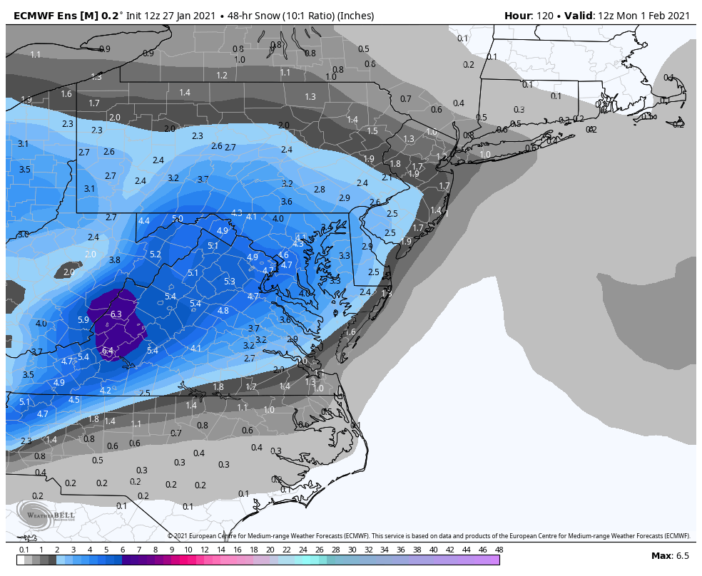
Here's the EPS through this part of the storm. Keep in mind this is in 10:1, and even in the EPS the mean is starting off the storm with temps in the upper 20s. Even in 10:1 it shows the potential for a pretty great WAA thump. Really nice that the other half (and more) of the snow mean for the general DC area comes from after this.

-
Cluster seems slightly SE of 6z, but I think that's because it dropped the outliers that take the lp all the way through the bay.
.thumb.png.be17bc40485514037442a442cc343bfc.png)
-
Would the banding be super important to the thermals? The Euro uniformly has mid 30s while the costal cranks, and I'd imagine that works super well for a paste bomb where it dumps 2" QPF, but not for light rates. Just hoping that thermals ease a bit once we get to mesos range
-
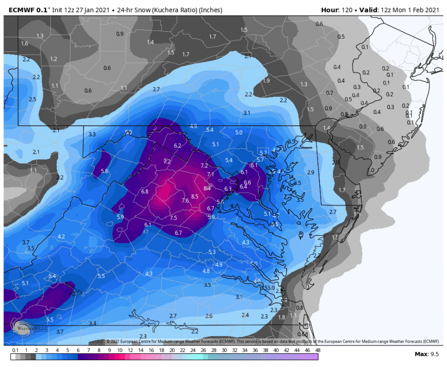
To start off.. this is my biggest takeaway from that run. This is all the snow that accumulates before mixing issues reach even EZF. If we get 6-8" before worrying about the costal.. that's a colossal win
-

January Storm Term Threat Discussions (Day 3 - Day 7)
Cobalt replied to WxUSAF's topic in Mid Atlantic
Canadian ensembles juiced up compared to 0z.
-
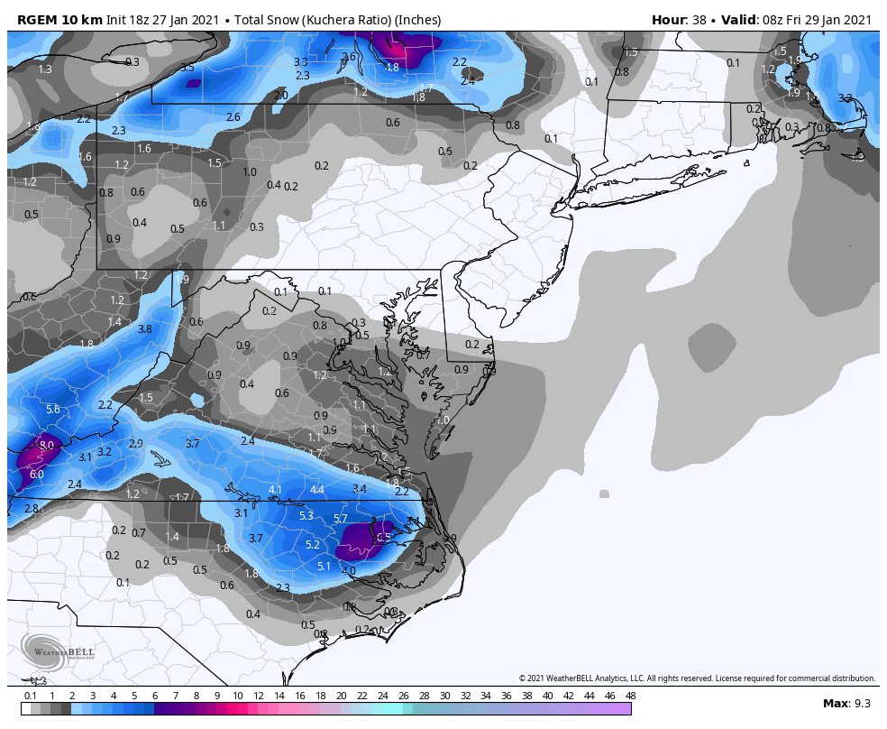
January Storm Term Threat Discussions (Day 3 - Day 7)
Cobalt replied to WxUSAF's topic in Mid Atlantic
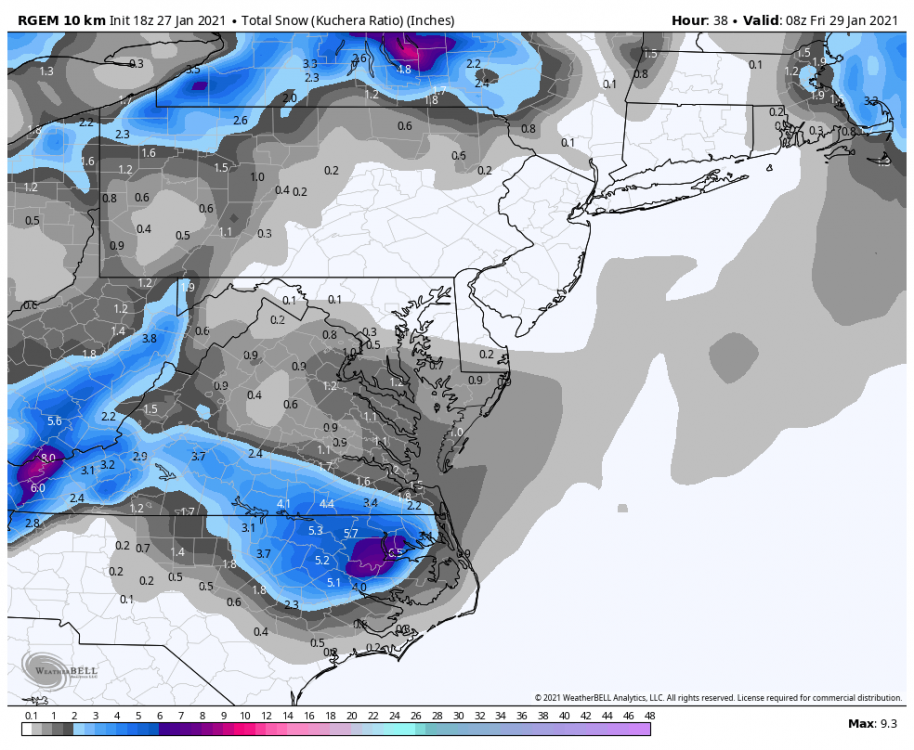
@clskinsfanthat's 0z's Kuchera map. 12z looks pretty decent forum-wide through 132 and still snowing. Will post when those panels come out. -
January Storm Term Threat Discussions (Day 3 - Day 7)
Cobalt replied to WxUSAF's topic in Mid Atlantic
I've been following this aspect and have compared based on range. At this time (around 0z Sunday so 114 hours from Thursday onset), was when we had a pretty amped and great look on both the GFS and GEFS, and everything else was not as enthusiastic. Then in the following 24 hours the GFS caved. I'm not sure which met said that the GFS likes to make errors and then take 30 hours to correct, but let's hope this is one of those scenarios. Certainly something to watch. -
January Storm Term Threat Discussions (Day 3 - Day 7)
Cobalt replied to WxUSAF's topic in Mid Atlantic
Let's face it, is a Miller B in a La Nina really our best chance of cashing out on a flush hit HECS? My assumption would be no, but others still have the biblical Euro amounts cemented into their heads. Although the EPS is definitely more bullish than the GFS/GEFS has been as of so far, so the fact that our ground floor it seems is still 3"+, Im not sure we have a right to complain. -
January Storm Term Threat Discussions (Day 3 - Day 7)
Cobalt replied to WxUSAF's topic in Mid Atlantic
Most if not all of that comes from the initial WAA thump before the primary has a chance to wreck thermals. Obviously the GFS and Euro are still worlds apart with the actual costal aspect. -
January Storm Term Threat Discussions (Day 3 - Day 7)
Cobalt replied to WxUSAF's topic in Mid Atlantic
Im struggling to find the disaster.. Kuchera is even higher. Wasn't the GFS still showing a flush hit for Thursday this far out?? The ground floor of basically all guidance has been 3-6".. -
January Storm Term Threat Discussions (Day 3 - Day 7)
Cobalt replied to WxUSAF's topic in Mid Atlantic
Gotta fear those miller B ice storms! -
January Storm Term Threat Discussions (Day 3 - Day 7)
Cobalt replied to WxUSAF's topic in Mid Atlantic
The Euro is close to being a southern outlier compared to the EPS.. in intensity too it seems. the EPS did not like what the Euro decided to throw out tonight. Euro for reference.thumb.png.57d3649be5bd31139e1d49fb92848072.png)
-
January Storm Term Threat Discussions (Day 3 - Day 7)
Cobalt replied to WxUSAF's topic in Mid Atlantic
Mhm, the preicp mean for the costal aspect is improved too. In fact part of it might be because a cluster of means are decently NW during this time (disagrees with Euro), in fact 850s are borderline for part of that, but that's probably the least of our worries atm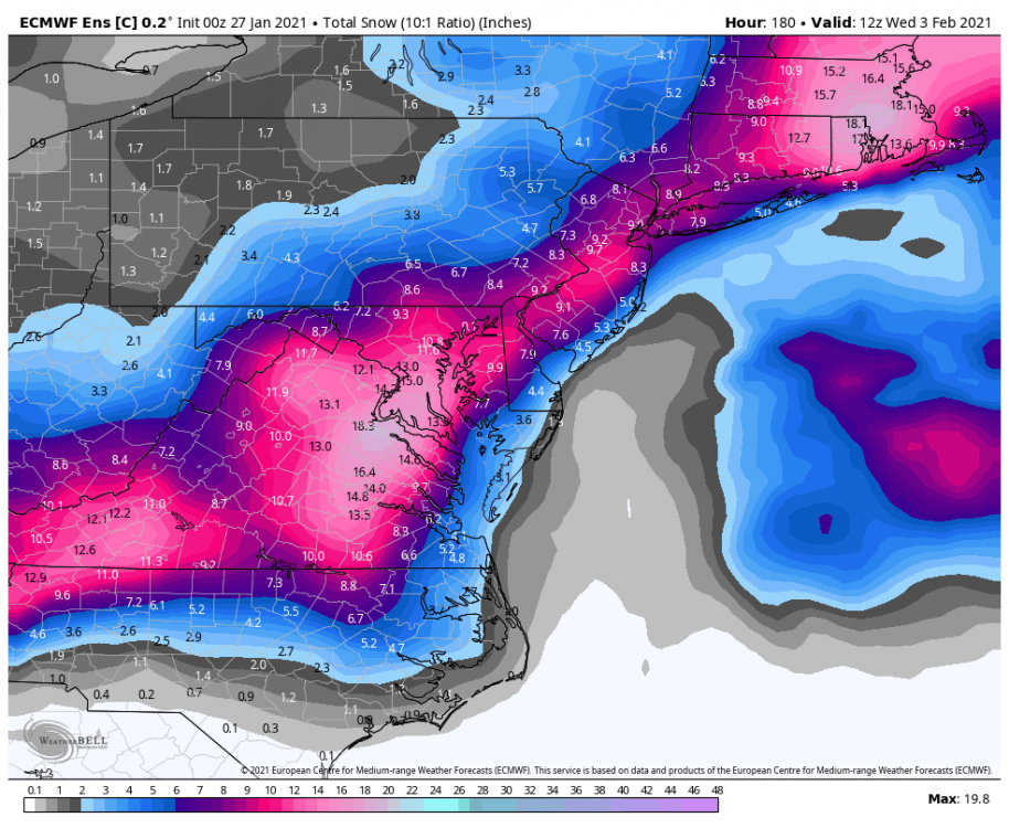
-
January Storm Term Threat Discussions (Day 3 - Day 7)
Cobalt replied to WxUSAF's topic in Mid Atlantic
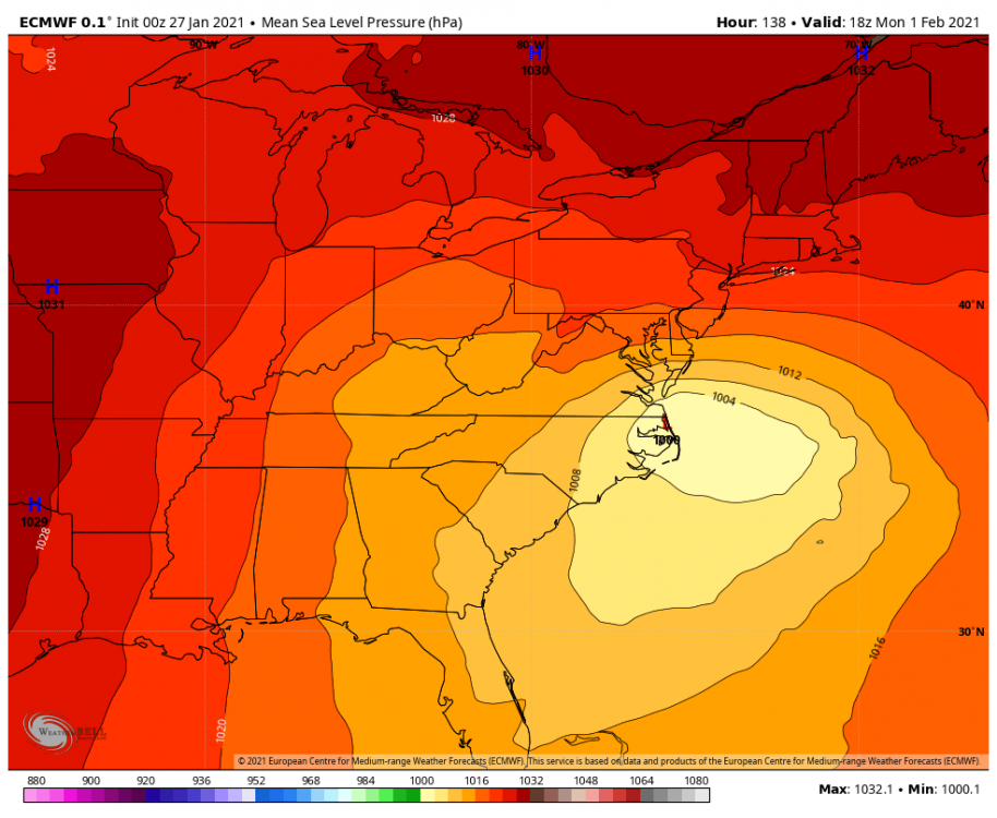
This is actually NW of 12z lol Control is still a bomb too. Weird that the EPS went up pretty well compared to it's Op brother.
.thumb.png.ad75e029ce0d539c72617a50eb8ffcf4.png)
-
January Storm Term Threat Discussions (Day 3 - Day 7)
Cobalt replied to WxUSAF's topic in Mid Atlantic
The EPS looks pretty similar to 12z, if not a tiny bit North. Certainly not a step back. I'd imagine that ensembles are pretty decent at this range.


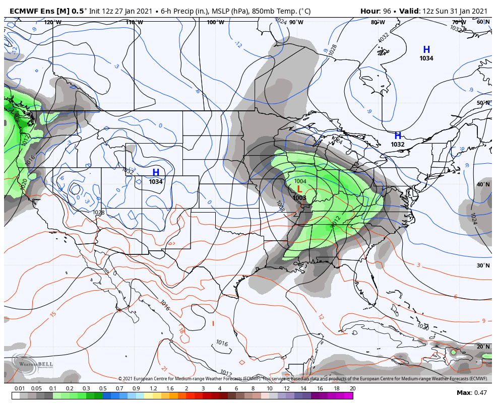


.png.535d088139fb9f5025c5f8d7fb938706.png)

.png.d7e9b894ebfe3a9f95988edaef8c6a80.png)
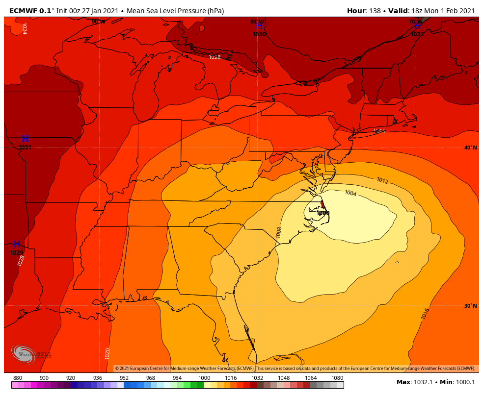
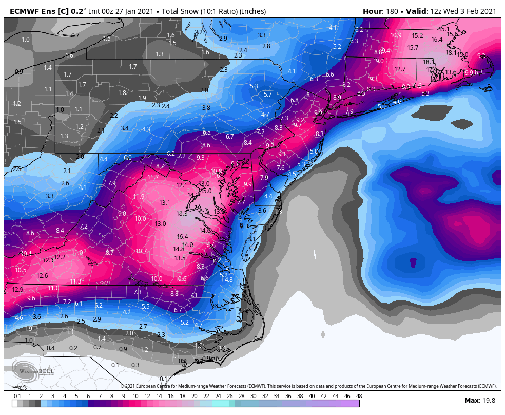
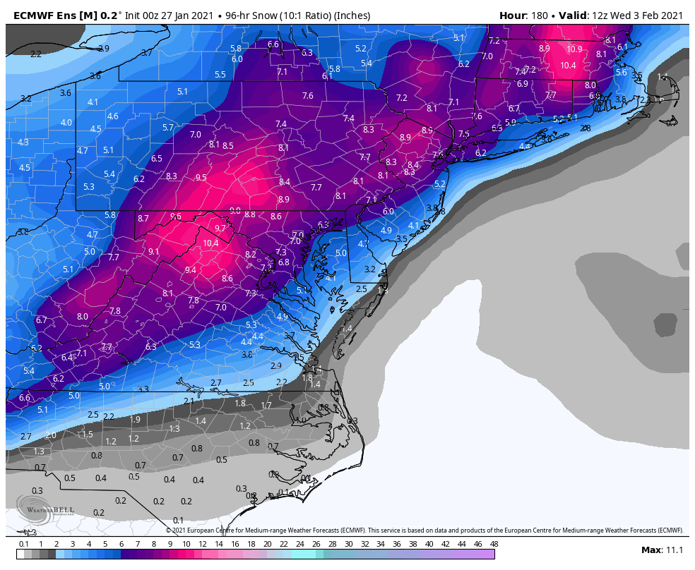
.png.c83d14009c6e455f7ab1042c276c4947.png)