GunBlade
-
Posts
482 -
Joined
-
Last visited
Content Type
Profiles
Blogs
Forums
American Weather
Media Demo
Store
Gallery
Everything posted by GunBlade
-
 The low reforming over the mountains is what’s killing us (imby), bringing that warm air much further north.
-
That verifies. It has the Asheville snow hole
-
It's like Allan knows where I live drawing his B/E line lol
-
It's been so many years it's hard to remember. However, I feel like almost all miller a storms went through this trend. They were amped up and juicy, 2 days before models lost it, got warm, lost precipitation and more then began to bring it back in and settle on a solution in between the two extremes. Wouldn't be surprised to see these massive shifts settle to an intermediate solution throughout the day with finer details beginning to come in to focus tomorrow.
-
I’ll take weaker, cooler and especially south all day over an amped up mix of precip. So often the warm nose screws us in the clt area
-
A friend of mine used to live on the 50th floor of the Vue in downtown Charlotte. He went out on his balcony one morning and it was snowing. When he went downstairs to walk to work it was raining....That is what we are working with nearly every storm in this area
-
You’re looking at 1/14 not the 1/10-1/11 storm.


-
Miserable cold rain here.
-
NW trend has not been our friend this year so guess I’ll bank on the SE trend and go all in on the storm the GFS is showing at the end of its run
-
Being in the SE, seems like there’s rarely better snow than what a good ULL rolling through generates. As long as it’s passing south of you. Their dynamics result in amazing rates with nice big flakes that add up fast.
-
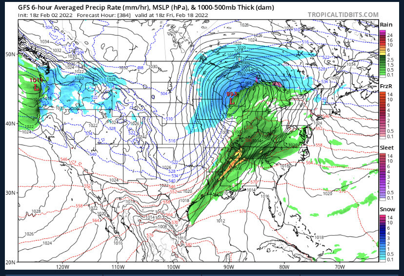
Potential 1/28-1/30 2022 winter storm
GunBlade replied to Prismshine Productions's topic in Southeastern States
I’m only a couple miles from CLT and woke up to snow covered ground. Can’t call a bust before the modeled snow even arrives.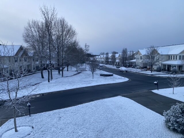
-
Potential 1/28-1/30 2022 winter storm
GunBlade replied to Prismshine Productions's topic in Southeastern States
The point isn’t the totals or what the models say right now. It’s the fact that so many people were hoping for that band to give them a chance and then complained about rain and temps 4 hours before it’s supposed to form. Also, the models don’t show most of the precip falling right now so who knows what to believe anymore.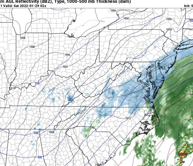
-
Potential 1/28-1/30 2022 winter storm
GunBlade replied to Prismshine Productions's topic in Southeastern States
Funny how a little rain makes everyone forget what the models actually showed. The meso band some of us have been hoping to give us an inch or two hasn’t even formed yet and wasn’t supposed to until around midnight or later.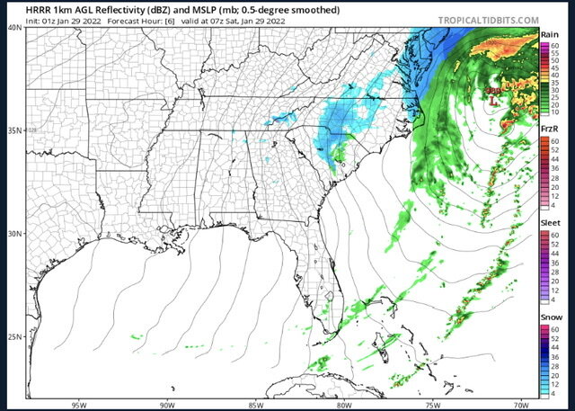
-
Potential 1/28-1/30 2022 winter storm
GunBlade replied to Prismshine Productions's topic in Southeastern States
Way too much southern energy being strung out and left behind. That’s why the phase is occurring so late and weak. -
Potential 1/28-1/30 2022 winter storm
GunBlade replied to Prismshine Productions's topic in Southeastern States
Canadian had a little better phase as well. Little stronger and further west. The ridge out west has been strengthening too the past few model runs. -
Potential 1/28-1/30 2022 winter storm
GunBlade replied to Prismshine Productions's topic in Southeastern States
Is that the Chrysler Jeep Dodge and Ram dealership across the street? If so, our good friends live less than a mile down the road off of Amos Bridges Rd and Waters Edge Dr. -
Potential 1/28-1/30 2022 winter storm
GunBlade replied to Prismshine Productions's topic in Southeastern States
The point being is that the low that forms is not way east OTS. Yes the low is weaker because the phase is weaker and is why the NE misses out. -
Potential 1/28-1/30 2022 winter storm
GunBlade replied to Prismshine Productions's topic in Southeastern States
That isn't the LP that forms from the phase in the 18z run. This run was a little slower and weaker so you have to go out a couple more frames for the LP that forms.
-
Potential 1/28-1/30 2022 winter storm
GunBlade replied to Prismshine Productions's topic in Southeastern States
Ouch....
-
Potential 1/28-1/30 2022 winter storm
GunBlade replied to Prismshine Productions's topic in Southeastern States
Canadian looking alot like GFS so far. See how it plays out. -
Potential 1/28-1/30 2022 winter storm
GunBlade replied to Prismshine Productions's topic in Southeastern States
Exactly. We (CLT) would really need this to be neutral or negative at hour 60 when that low is off the coast of SC to get us in the NW precip shield and allow it to bomb out by the time it is to the NC coast. That causes issues for eastern NC early in the event, but they still do well as the low is passing them.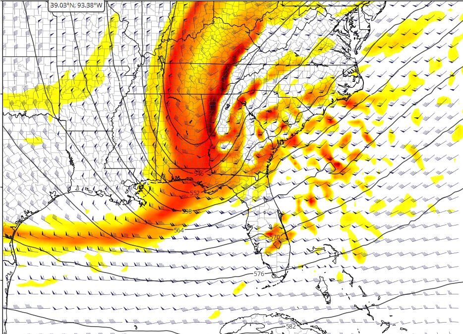
-
Potential 1/28-1/30 2022 winter storm
GunBlade replied to Prismshine Productions's topic in Southeastern States
The GFS looks good overall and the low forms in a good location. It’s just that southern energy is so strung out from being held back that there’s not enough juice in the atmosphere to get the precip really going until it’s too late for most. -
Potential 1/28-1/30 2022 winter storm
GunBlade replied to Prismshine Productions's topic in Southeastern States
Yea that southern energy just sits back west much longer -
Potential 1/28-1/30 2022 winter storm
GunBlade replied to Prismshine Productions's topic in Southeastern States
Yup, great low location off the coast of Florida. If that phases early enough and rides up the coast there will be alot of happy people. -
Potential 1/28-1/30 2022 winter storm
GunBlade replied to Prismshine Productions's topic in Southeastern States
Little weaker and later phase than 6z run. Much later than NAM so the low is too far north and east by the time it forms. NE NC outerbanks get good snow but not much else.