GunBlade
-
Posts
482 -
Joined
-
Last visited
Content Type
Profiles
Blogs
Forums
American Weather
Media Demo
Store
Gallery
Everything posted by GunBlade
-
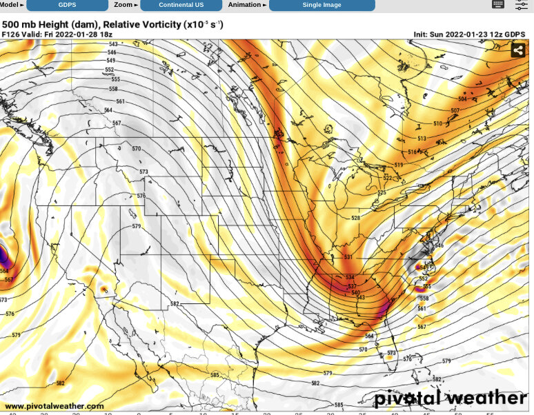
Potential 1/28-1/30 2022 winter storm
GunBlade replied to Prismshine Productions's topic in Southeastern States
I could be wrong. Looks deceiving but that secondary low that forms ahead of our main low is way off the coast. Once our energy phases and forms a new low, that secondary low dissipates. So it looks like the low comes flying up from the SE but that’s really the secondary low dissipating and our main low forming. -
Potential 1/28-1/30 2022 winter storm
GunBlade replied to Prismshine Productions's topic in Southeastern States
Jackpot for coastal areas and eastern NC though.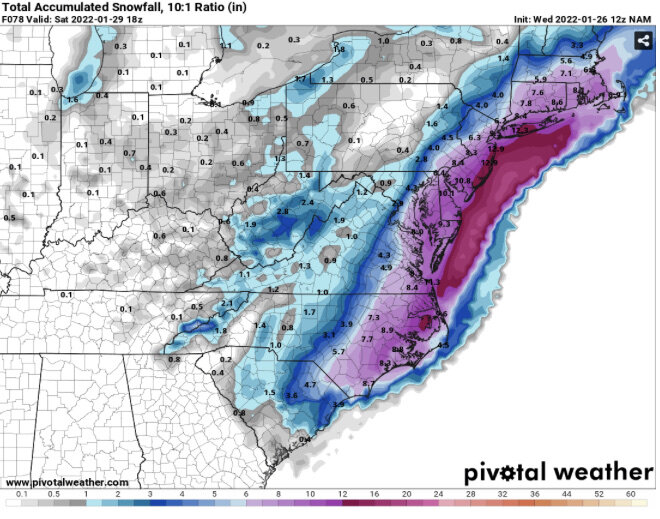
-
Potential 1/28-1/30 2022 winter storm
GunBlade replied to Prismshine Productions's topic in Southeastern States
Yea leaves less energy behind than the last run, much closer to 00z run. Phase looks at little stronger but little too late to jackpot central NC. -
Potential 1/28-1/30 2022 winter storm
GunBlade replied to Prismshine Productions's topic in Southeastern States
Yea NAM is about to really wind this one up.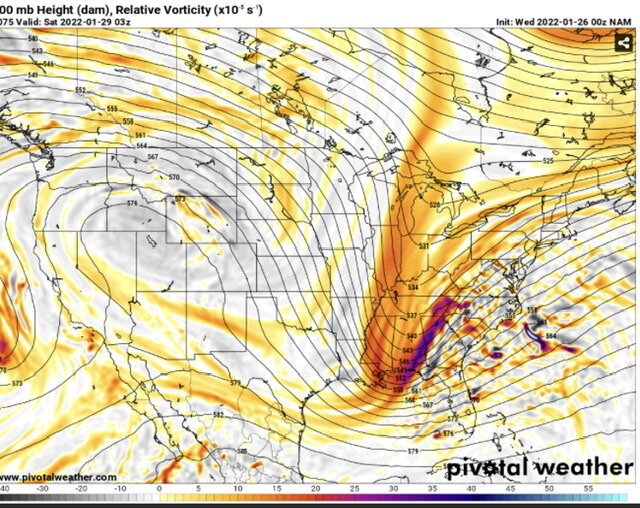
-
Potential 1/28-1/30 2022 winter storm
GunBlade replied to Prismshine Productions's topic in Southeastern States
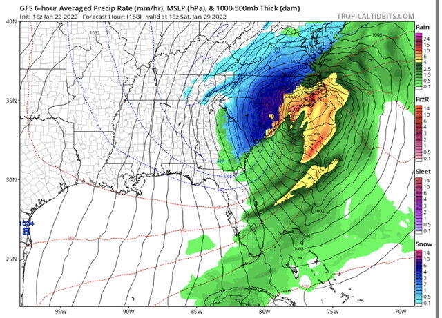
The back and forth uncertainty will likely not stop anytime soon. Short range models don’t even have the current low in the gulf modeled very well. Quite a bit more moisture than shown. Going to be a long ride this week.
-
Yup "GDPS and RDPS maps may be delayed or missing due to data flow problems at Environment Canada"
-
The 06z NAM looked like it was on track for a better phase sooner. RGEM looked pretty good as well. The 12z NAM looks like it’s on its way to improve upon the 06z.
-
Not crazy. That’s the same low that phased and bombed out off the coast on the GFS 18z yesterday and has come and gone.
-
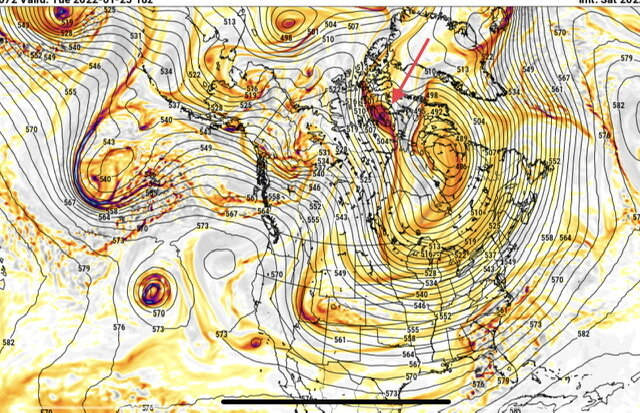
Yea we need that ULL diving down from the arctic to be a little stronger and/or slower to help those waves dive down more in the plains instead of coming down through the Midwest/Ohio Valley. Canadian is showing the storm now as well. Still a little late to phase but nice to see it showing up. Biggest thing I’ve noticed is Canadian and others have the energy about 12 hours ahead of GFS which has caused them to not phase or dive down through the Ohio valley and phase too late. In a couple more days the location and timing of those waves in Canada should become clearer.
-
Canadian didn’t get it done either. But the players are on the field. Pay attention to that ULL in Canada on future runs. It helps drive the other waves south and west in the 18z GFS screenshot. It’s much weaker on the 00z GFS and let’s the other waves coming from Alaska slide further east and down through the Midwest instead of the Great Plains. The Canadian is even weaker but then also a little faster with the energy coming down from the arctic and ahead of it. Allowing those waves to slide even further east and then ejecting some energy southwest into the plains. The remaining northern energy eventually phases with a third piece of energy coming down from Alaska. By then though it’s so far east and north the low forms off the coast of SC instead of down in the Gulf.
-
For anyone who hasn’t done it let any long range model auto play the entire run and watch all of the northern waves coming our way, diving down, one after another and southern waves coming across Texas and the gulf. The past few years we can’t get this type of pattern for an extended duration. Our best bet for big snows down here is those waves coming together perfectly to create the storm the GFS has been hinting at next weekend. I feel like we used to hope for lows coming into the gulf being suppressed down to Cuba because we at least had a shot at the high moving out faster and the low turning up the coast. Instead we’ve had app runner one after another or no cold air. Whether next weekend happens or not, there are ALOT of opportunities in the next 10 days for those waves to give us at least a shot at something good and temps look to be as good as we can hope for in the SE. And in the end at least we have something to track and hope for. For the pessimistic Ted Lasso fans, it’s the hope that kills you. The rest of us will let you know when there’s no hope again.
-
So does this!

-
After several hours of snow the latest HRRR totals look nearly the same as they were showing for the whole storm earlier today lol. Gotta love SE winter weather.
-
That was my thought as well. What the ice doesn’t bring down the snow piled on top at the end very well could.
-
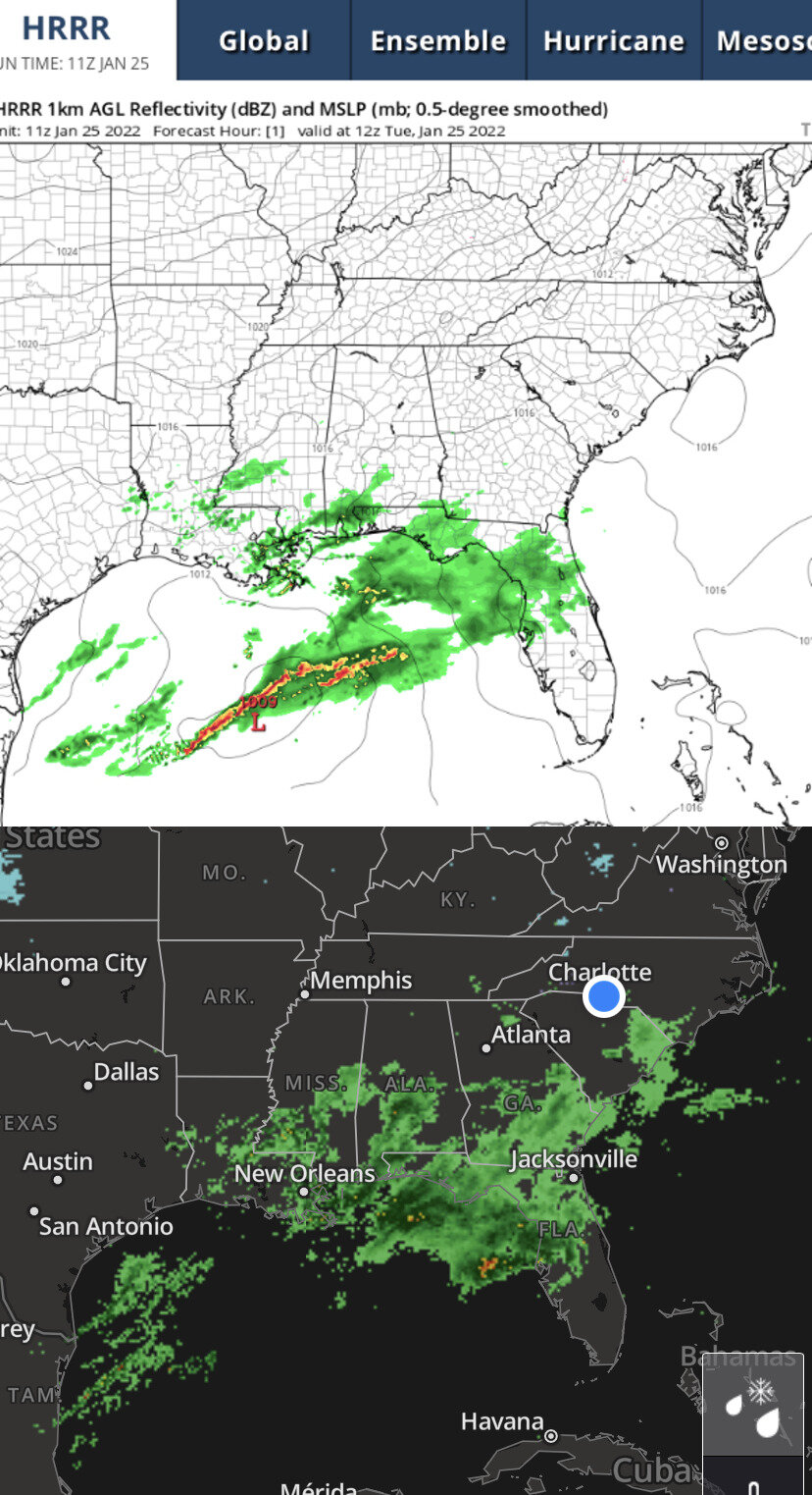
For anyone near the coast in the freezing rain how are things there? Radar has looked no bueno.
-
Rates really picking up here in Matthews as well. Going to be a pretty sight tomorrow morning.
-
I think most people down here see snow so little and it melts so fast they want totals over duration. For me, there’s nothing better than watching it snow from sunrise to sunset. But in the end I’d prefer higher totals over duration in hopes it sticks around for more than 1 or 2 days to enjoy with the kids. For reference, the storm last week was Charlotte’s first 1” or more snow in 1,133 days. Pretty dismal. Every snow could be the last one we see for years so emotions run high with every one.
-
Nearly every model is showing the western snow shield starting to build back up around this time and drop a couple inches in CLT between now and 1 am. Hope they’re right and we can somehow squeeze out a decent little event here.
-
Right now it’s 30 in Matthews with a -7 dew point….wow.
-
January 20-22 “bring the mojo” winter storm threat
GunBlade replied to lilj4425's topic in Southeastern States
Sorry was having issues on VPN getting images to work. Here you go.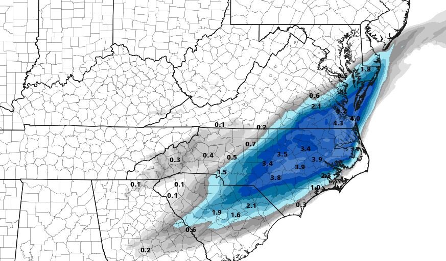
-
January 20-22 “bring the mojo” winter storm threat
GunBlade replied to lilj4425's topic in Southeastern States
15z HRRR giving CLT a little more love as well with 1.5" this run. -
January 20-22 “bring the mojo” winter storm threat
GunBlade replied to lilj4425's topic in Southeastern States
This does not actually close off to an ULL. That map is also lower level pressure -
January 20-22 “bring the mojo” winter storm threat
GunBlade replied to lilj4425's topic in Southeastern States
RAP is looking great as well. Going to be a good run. -
January 20-22 “bring the mojo” winter storm threat
GunBlade replied to lilj4425's topic in Southeastern States
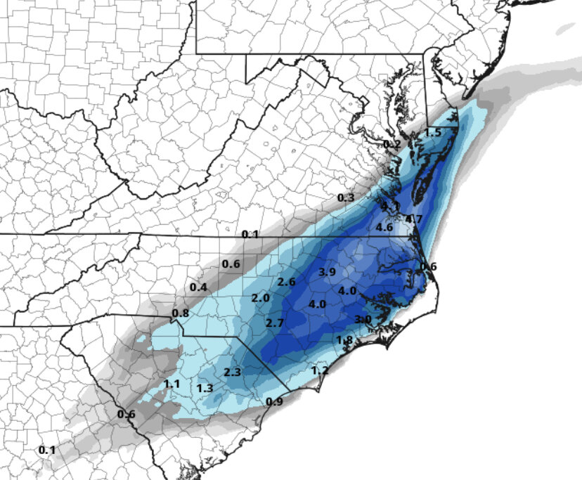
GFS decreased totals by about 1/2 inch for many areas and even more for some. Northern wave was a little weaker and looks much like the 18z RGEM overall with slightly lower totals. -
January 20-22 “bring the mojo” winter storm threat
GunBlade replied to lilj4425's topic in Southeastern States
18z RGEM actually has lower totals for nearly all of NC and SC outside of the NE corner of NC into VA. Still looks better than the NAM, but moving toward lower totals isn't the trend I would want to see.