

Scarlet Pimpernel
-
Posts
7,346 -
Joined
-
Last visited
Content Type
Profiles
Blogs
Forums
American Weather
Media Demo
Store
Gallery
Posts posted by Scarlet Pimpernel
-
-
11 minutes ago, KChuck said:
An earlier Buffalo NWS disco said that an omega block was keeping the area clear the prior weekend and that eclipse cloudiness would be dependent upon how fast that block breaks down.
For those of us who will be going into IN/OH/PA/western NY (I, myself, will be visiting family in the Cleveland area for this)...hard to know what to root for. That shortwave in the upper midwest seems to be problematic, from what I have been looking at of late? Do we hope for that shortwave to either be weaker, or farther northwest (or both), such that the ridging through the Ohio Valley and east remains more intact? It seems that wave is knocking down the ridging a bit more but I've only taken cursory glances at the models the past few days.
-
 1
1
-
-
24 minutes ago, WxUSAF said:
I’ve got nonrefundable hotel and airline. I’m coming to Texas. The rain will be dark at least.
I'm actually not quite sure what to root for, for anywhere along the path. It seems pretty set right now that if you're in the northeast US, it is looking like the best chances for clear. But from western NY into TX along the path, it gets dicey. Do we hope for that southwestern trough to slow down enough so that the southwest flow of moisture doesn't get to TX and points northeast until after it's over? Or at least not enough to ruin things. And what about that shortwave that's now coming into the upper midwest, that could adversely affect things in IN/OH/PA/western NY? That sort of seems to have gotten stronger and pushed the ridging in the Ohio Valley and east down a bit from what I saw. I kind of hope that shortwave ends up being farther northwest (and/or weaker?) to allow the ridge to stay intact enough at least into Monday evening.
-
Well, I'm casting my lot at my brother and sister-in-law's place in the Cleveland area, south of town. Not much choice. Going up there Saturday and returning on Tuesday. I contemplated trying a "secondary" location within an hour or so drive of Cleveland if it looked like it might be clearer the day before, but now just think it won't be worth it. You'd probably have to go a fair bit more to find much different (better?) sky conditions anyhow. Not to mention, I don't care to deal with the mass of crazy traffic and even crazier crowds anywhere along the path, in a place I don't know or don't know exactly where to park and station myself. Just don't have the time, finances, or desire to have backup and backup-of-backup plans, honestly. My hope is that it's reasonably clear enough at least in parts of the sky to see it, or maybe some high but see-through thin clouds...just not thick, socked-in clouds and/or rain. That's really all I expect in that area to be honest. If it's good enough, we'll be able to watch it right from their yard, on the deck! Can't get much easier than that. And, worst case as I said before, if it's crap with complete overcast, at least I can have a fun couple days' visit!
-
40 minutes ago, nj2va said:
If Illinois can stay hot from the field, they have a shot. But the guy who bet $250K this week for UCONN to win is closest to safe money you can get.
Certainly agree about UCONN...they're playing like they're on a mission. But I doubt they'll blow out Illinois, that should be quite a game I think, though UCONN will probably still win.
As a Purdue grad, I just hope the Boilermakers can actually at least make it to the Final Four. Too many disappointments by them when they've had really good teams, it's about time they get that far, if not to the Finals. But I'm wary and would not be surprised if they don't make it past this weekend.
-
5 minutes ago, PrinceFrederickWx said:
Same here. We're just going to the house we have booked in Ohio and rolling the dice at this point. It'll still get dark and we've never been to Ohio, so it'll be a fun trip at least seeing a new state.
Yup, I hear you! I hope you have a great time in Ohio, regardless of how the weather is for the eclipse! But hopefully that will cooperate as well! I grew up in northeast Ohio, which is why I'm familiar with how early April can be. It's not always crap, but it's not typically the best time of year for good weather (hell, the Indians/Guardians have had games SNOWED OUT before!!!). All I can do is cross my fingers that at least a few hours Monday afternoon will be nice enough.
-
1
-
-
I'll be visiting my brother and sister-in-law in the Cleveland area for the eclipse. My expectations there are not the greatest, as I'm all too familiar with the fact that northeast Ohio plus early April typically equals crappy weather. Not much you can do about it and I'm not in a position to have various disparate locations to go to if needed, on very short notice. However, if by chance it looks cloudy where my brother is but somewhere within say 50 miles is likely to be clear, we may well just drive early on the 8th and set up to watch there. But even that would have to be spur-of-the-moment.
My hope is that it's at least reasonably clear for the event. I certainly don't expect completely clear, blue skies with not a wisp of clouds. Not in April in Ohio. As long as it's decently visible in that time frame through the duration of the eclipse I guess. Worst case scenario, I figure, is that we're socked in with crap and it's just a fun couple of days' visit all the same.
-
49 minutes ago, George BM said:
A number of birthdays in here today. Happy carrot cake/IPA day to those of you celebrating.
Yup, mine is today, though I'll stick to red velvet cake myself! Oh, and @vastateofmind, happy birthday to you as a fellow March 25th-er!!!


-
2
-
-
17 minutes ago, WxWatcher007 said:
Some programs you can almost bank on collapsing/underachieving in March. Despite the championship, UVA is one of those programs IMO.
There's always my undergrad alma mater, Purdue! They seem to perpetually choke or otherwise flub the tournament even when they have a high seeding. And...they suffered upset losses TWICE on my birthday, in seasons they were anticipated to go pretty far. First was 1988, they had the Midwest #1 seed, a very solid team and widely expected to get to the Final Four. They lost on Friday, March 25, 1988 to #4 seed Kansas State (whom they actually beat handily in a regular season game) in the Sweet 16. I was at Purdue at that time, a group of us was watching the game that evening just stunned in disappointment. They lost AGAIN on Friday, March 25, 2022 as a #3 seed to the #15 seed St. Peter's in another Sweet 16 round. Then of course last year they shared the dubious distinction of being the second #1 seed to lose to a #16 (Virginia being the first to do so a few years before). At least THAT wasn't on my birthday! And, at least this year they cannot lose on that day since March 25 is a Monday and there won't be any tourney games on that day!!
This year I fully expect them to not get past the Sweet 16, or if they're lucky maybe they'll get to the Elite 8. But we'll see.
I also am from Cleveland, so I am very familiar with sports agony! LOL!!!!

-
2
-
-
2 hours ago, paulythegun said:


-
1
-
-
8 hours ago, ravensrule said:
Fixed.
Hahaha! I would have never thought that post by @Deck Pic would be a RR bat signal, but there ya go!
But I guess it's like anything else, it's in the eye of the beholder what one sees! There's a Tom Lehrer song called "Smut", and one line goes "When correctly viewed...everything ls lewd!"
-
1
-
-
On 2/29/2024 at 10:51 PM, George BM said:
Forecast Discussion
Saturday, March 16, 2024 3:28PM EDT
Blizzard Warning in effect from 8AM EDT Sunday, March 17, 2024 until 3PM EDT Monday, March 18, 2024
High Wind Warning in effect from 9AM EDT Sunday, March 17, 2024 until 6PM EDT Monday, March 18, 2024
Hurricane-Force Wind Warning in effect from 2PM EDT Sunday, March 17, 2024 until 6AM EDT Monday, March 18, 2024 (for tidal-Potomac and Chesapeake Bay)
Life-Threatening Late-Winter Storm to cripple the region.
Temps are currently holding in the mid-50sF across the DC metro area but are already starting to fall in far northern Maryland as the cold front associated with the strong northern stream system drops south through the region. Temps will plummet out of the 50s and through the 40s and 30s through the evening and reach the lower 20s in many areas by morning as the unusually cold airmass pushes in. As this occurs through the late afternoon and evening hours skies will become overcast both from lift associated with the southward moving cold front and from the strong southern stream system to our south/southwest. There may be enough lift and moisture associated with the front for some light sprinkles and/or a few flurries/light snow showers to develop through the evening before precip slips to the southeast. Northerly winds will become quite gusty during this time with gusts of 25 to 40 mph.
As the strong southern storm system moves toward the coastal Carolinas tonight it will begin to phase with a second powerful northern stream vort diving south from the eastern Great Lakes/ Toronto region leading to strong diffluence over the surface low leading to rapid deepening. The two will pinwheel around each other as they phase bringing the southern storm and associated surface low northwards as rapid deepening takes place allowing snow to overspread the region by morning from southeast to northwest. The snow will quickly become heavy as NE winds increase with gusts to over 50 mph across the region likely by midday. Temperatures during this time will be in the lower 20sF leading to windchills in the single digits. By the late afternoon/evening the surface low will slow down and eventually stall over the Virginia peninsula/ southern Chesapeake Bay area. The surface pressure could be as low as the mid-950s in millibars breaking monthly low-pressure records in that area. Meanwhile, the areas northwest of the surface low (the greater Washington DC and Baltimore metros) will be getting the worst of this storm with blinding snowfall and widespread 60-75+ mph wind gusts w/ 80-90+ mph gusts along the coast of the Bay. In fact, snowfall rates in the heaviest bands will likely be in the 4-6”+/hr range leading to visibilities as low as 50 feet (effectively zero visibility for the sake of argument) from the late afternoon hours through the night and into Monday morning. Temperatures will remain in the 20s throughout the duration of this event with upper teens possible in the higher elevations north and west and temperatures closer to 32F in far southern MD and along the bay where warmer air will be located near the surface low. Windchills during the duration of the event will stay in the single-digits for most w/ negative single-digits in the mountains and lower teens in southern MD and along the bay.
Near-whiteout and conditions and severe wind gusts will still be ongoing by dawn Monday as the low-pressure system slowly pulls northeastwards. Heavy snow will continue through the late morning to midday hours before tapering off from west to east. When all is set and done with total liquid-equivalent precipitation of 4-7”+ across the region, snowfall totals of 4 to 6 FEET will likely be commonplace with snow drifts of as high as 30 feet possible. Areas in southern MD and near the Bay may end up with slightly less (roughly 2 to 4 feet) as the warmer air associated with the low-pressure center cuts down on totals in that area.
This will be the worst blizzard, by far, to impact the region since weather records started in the later 1800s. It will essentially be a high-impact hurricane with snow instead of rain as the main precip-type. People who venture outside during this time may get disoriented and lost in the whiteout conditions and/or get seriously injured by flying debris. Emergency services may not be able to reach you for days should something happen to you outside. This is the DC and Baltimore urban corridor not Lake Tahoe or the Japanese Alps. We’re not equipped with the snow removal equipment that they have. So, if you absolutely must venture outside during the storm no caution that you use would be too extreme given the circumstances.
Temperatures will only rebound to the lower 30s as skies start clearing by mid to late afternoon on Monday.
Forecaster Wannabe: George BM
Meh...DCA will only measure 17.8"!!
-
 1
1
-
-
30 minutes ago, Ji said:
we cant get away from cutters!
Ours is the eclipse after the eclipse, dontcha know!!
-
 2
2
-
-
2 hours ago, Ralph Wiggum said:
Taking up drinking for lent. On a tequila kick lately. Sipping on the Casamigos attm...not horrible, but there are better if you are willing to spend the $
Wait...I thought one is supposed to sacrifice and give something up for Lent. Not engage in further "sin"!!!
As for tequila, not normally a fan of it straight-up, generally prefer it in something like a margarita. Though I've had a couple several years ago that were remarkably smooth.
Personally, I prefer a fine single malt Scotch. Straight-up, not on the rocks. <ScottishBastardVoice>Aye, Laddie! Get yerself a REAL drink, a nice dram, will ya!</ScottishBastardVoice>
-
12 hours ago, WxUSAF said:
I’m on drought watch for summer
Expecting the Nats to have a bad season??
-
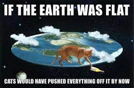
9 hours ago, psuhoffman said:
How does it rotate when it’s flat?
OK Kyrie, we have absolute definitive proof that the earth CANNOT be flat. Proven by none other than our feline friends millennia ago!
-
1
-
5
-
-
10 minutes ago, brooklynwx99 said:
lol dude it is a smoothed +2 meter anomaly. come on
Also, that's for...November! Can't be overly concerned about whether or not something can "work" in that pattern that early in the season. And it's like 8 months away, what's the point in hashing out details at this point?
-
2 minutes ago, Maestrobjwa said:
Well actually the rapture would take some the opposite of his direction

Very true...probably still enough left behind for his agents to "take care of!"
-
5 minutes ago, Ji said:
we need a +PDO with a west based Nino. If that dosent work.....then hopefully the rapture can just happen asap
Even though @WxWatcher007 is in retirement, I heard the Reaper still has his agents standing by the phones now to assist those in dire need...
-
2
-
-
Just now, stormtracker said:
This winter has made me bitter. Time to bring back tear Beethoven avatar.
Yeah, I think after the epic-looking pattern disappeared about a week ago, we definitely needed the Beethoven with the tear! That pretty well crushed everything.
-
8 minutes ago, stormtracker said:
He and his fucking Harpsichord using ass can go suffer eternal La Niña and a SER.
LOL!!!! OK, c'mon now...I love Beethoven and he's still my favorite composer. Unfortunately, I was unable to find an image or a gif with him doing an eyeroll!! So I settled for the Austrian dude...but don't diss his music TOO much!
(ETA: I await a lecture from @Maestrobjwa on the merits of Beethoven vs. Mozart and his harpsichord using ass!)
-
4
-
-
The Panic Room is still going?? Even when things are already done? C'mon!!!
-
2
-
-
32 minutes ago, WxUSAF said:
Need an eye roll reaction symbol
Mozart says...to that 46 day ensemble control snow map:

-
1
-
-
3 hours ago, Bob Chill said:
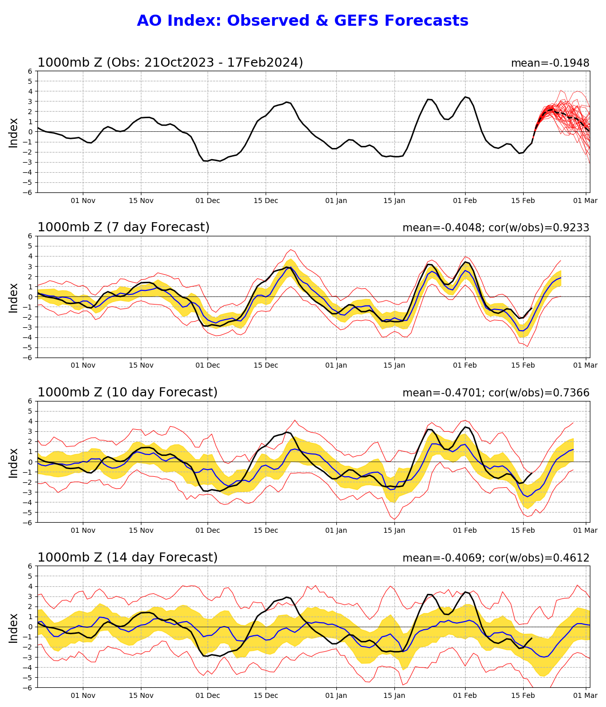
Long range is always volatile and unreliable. Models nailed most of Dec/Jan in general from way out in time. What really stung this year was a combination of holy grail expectations and applying that to all long range guidance. When we thought the upper level mean pattern out in time looked "classic nino" there were still plenty of problems lurking. Models were never cold and snowy under the hood. The only period that lit up 10+ days out with both snowfall and analogs was Jan. Other than that it's looked pretty bad to me.
I keep saying this but if we want snowfall, there is only one reliable feature that's a well placed/stable -AO. It can and will snow in any enso state when the AO is below -1. Conversely, an AO in excess of +1 can eliminate snow in any enso.
This speaks for itself imho. Not hard to see the correlation this year lol
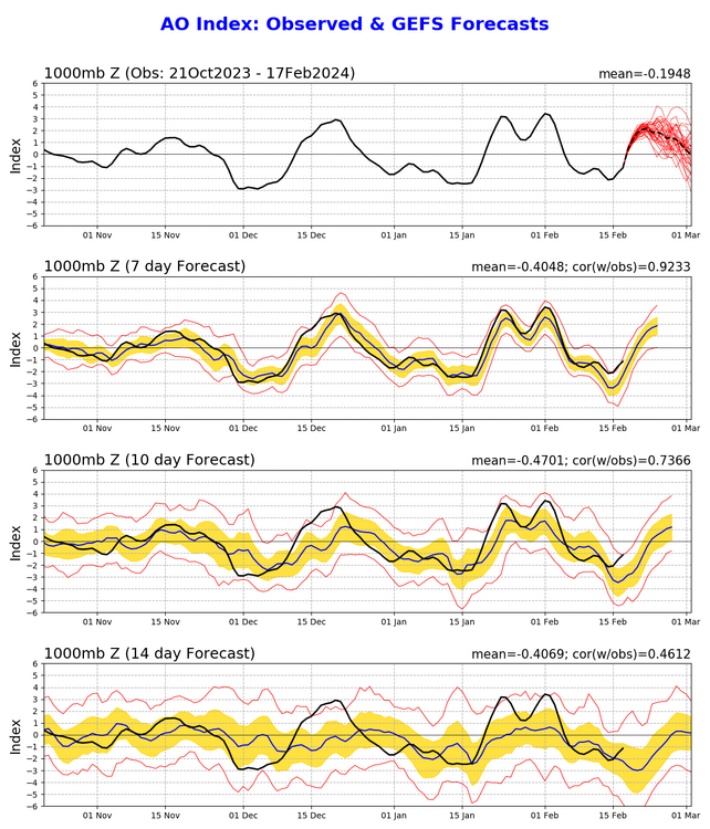
Something that really stands out is how bad models missed the abruptness and magnitude of the + moves from 10 days out. That's a big reason we spent so much time in a near shutout pattern. When the AO skyrockets, it's at least a 2 week reset before things can get cold and line up again and that includes going negative first.
I'm thinking this winter's underperformance isn't as complicated as first thought. The entire big winter thesis beyond enso was blocking. Dec was a big warning shot that wasn't happening as expected. Then things just kept repeating. If the AO stayed negative in Dec like big winters, those wet southern waves may have felt a lot different imo.
Good points here, Bob. I'll say that despite wanting to be optimistic about the highly favorable "holy grail" looks that showed up for mid-February to mid-March is that once things got a bit more into range, there really were no storms popping up. I know one cannot take those silly snow maps at face value, but typically when we see an approaching good pattern, crazy stuff starts to appear on the horizon in the ops and ensembles. That happened maybe a couple of times, I think, but it was basically "blah" looking and even kind of warm. That's the other thing, I didn't see a consistent "trend" or whatever toward colder, at least near the surface. Despite some good 850-mb cold looks. I was thinking to myself several times how nice 850 looked but shook my head at the BL temps.
-
3 hours ago, psuhoffman said:
You know I agree. But as ridiculous as it is that’s become political and I respect that they’ve banned politics from this forum for the sake of discourse. But now some have become emboldened to attack any mention of warming. That’s not politic MFer that’s just objective reality. It’s Fng wamer. That’s not a debatable thing. And I’m done with attempts to act like the FACT it’s warming is either political or not reality. There has to be a line in the sand against the crazy somewhere. This is mine.
PSU...I totally agree with what you say here. It's sad...pathetic...aggravating...that warming has become a political football (hot potato, as it were??). For F's sake, you cannot argue the data, humanity's influence in the past century or whatever, etc. I don't care what one's views are, this is just simply the reality. One's political views honestly shouldn't matter for something like this. But sadly, this is the bullshit reality we live in, and one feels helpless to do much about it when those in power and who have influence on policy, sit there and piss into the wind. Whatever. Sorry if I got too political there, but it's more than that. Fact is, all too many people can be so damned selfish and have no concern or care for how their decisions or policies may affect the world around them. Apologies...done with that rant.
-
2
-
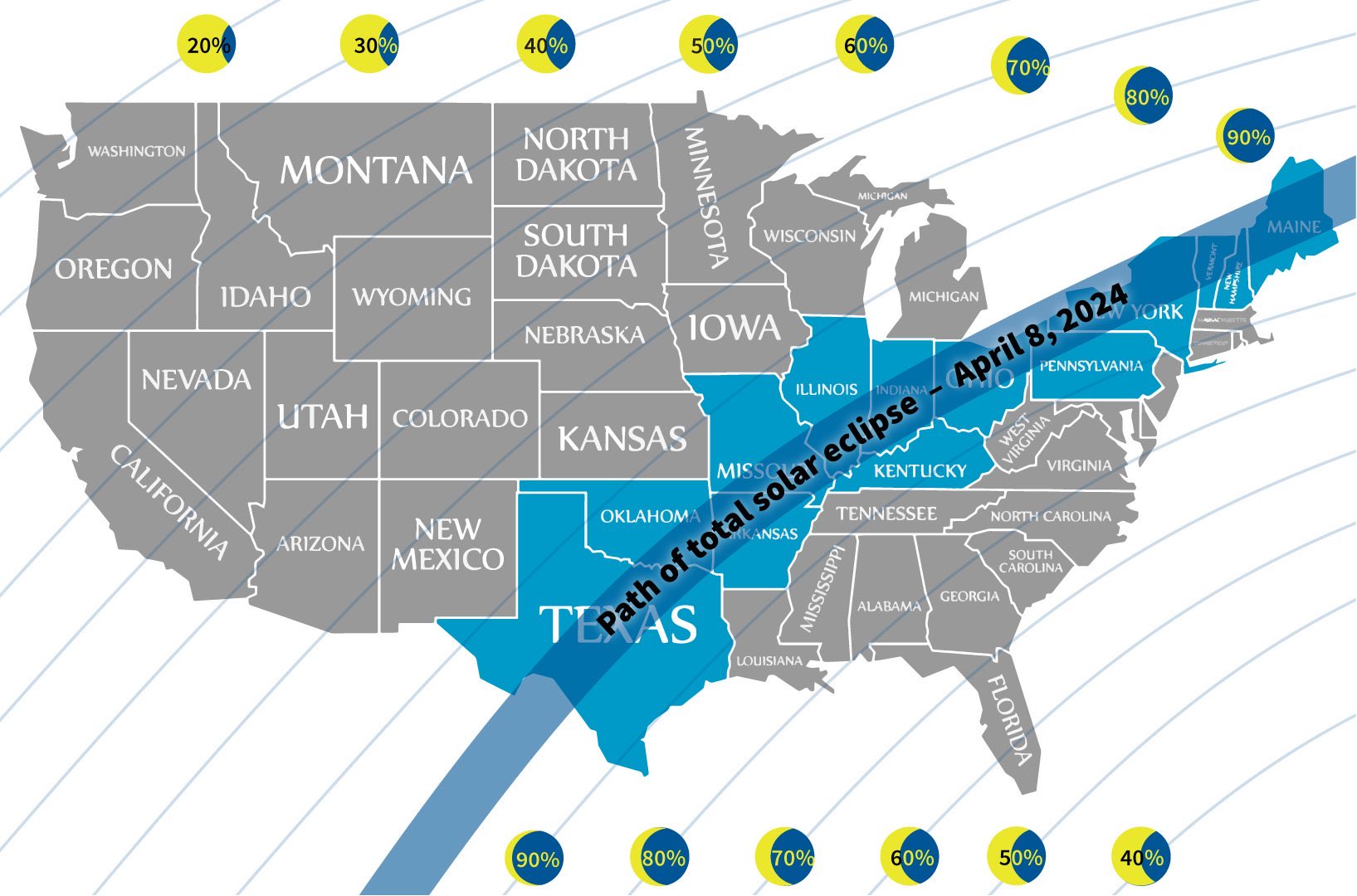
April 8th Eclipse- Last Easy One To See In My Lifetime
in Mid Atlantic
Posted
Ugh...GFS has trended toward a veritable actual washout for the Ohio valley/lower Lakes area. At least the GEFS ensembles are not so enthusiastic about that, though they hedged more in that direction. The Euro, as @baltosquid showed (at least from last night) is much farther west with that shortwave and associated low. Still iffy, but not a total skunk.
Heck...I almost wonder if the GFS-like solution is correct in the end, if it would actually be better if that system can speed up quite a bit and clear the area around the lower Lakes by Monday (and weaken it more), rather than being over that region on that day. It almost looked like the GFS was accelerating it a bit, in fact.