
BooneWX
-
Posts
1,320 -
Joined
-
Last visited
Content Type
Profiles
Blogs
Forums
American Weather
Media Demo
Store
Gallery
Posts posted by BooneWX
-
-
What’s weird is that if you compare the position of the low at hr 42 from 06 to 12z, the low actually is about 25-50 miles further out to sea
-
Warm nose made its return this run. Lets see what the rest of the 12z suite holds.
-
 1
1
-
-
Just now, buckeyefan1 said:
It looks good to me
Looked a little slower and spottier at first but it’s definitely making it up now.
-
Heavy snow at hr 39 after several hours of off and on/spotty snowfall
-
Nam at 33 not looking nearly as good
-
Cloud cover moving in during the morning could be a huge help tomorrow. Noticed the Nam has thick cloud cover over WNC by 12Z. Temps for the most part max out area wide 38-42. Certainly a big difference from hitting 50.
-
1
-
-
4 minutes ago, NCSNOW said:
Winter may just be getting started per the euro ensembles: Gonna be a fun 10 day stretch, maybe longer
Oh I meant 4-6 ft

-
3
-
-
I would gladly take 4-6 and cash out for the winter
-
1
-
-
Is it only me or do the sleet/frz rain issues seem a little odd in this setup? I’ve lived in WNC my whole life and I can’t think of too many times a low in that position had a ton of sleet or frz rain mixing in. Usually just rain or snow and no in between with sharp gradients.
-
1
-
-
8 minutes ago, wncsnow said:
GFS
.thumb.png.bb7b79631b9a4f6668f05b61d32b7465.png)
That’s a solid improvement!
-
Everybody take a deep breath on these OP runs. These are the same models that have squashed multiple systems this season only to bring them back within 48-72 hrs. They’re also the same models that have swung from 60s to 30s and back and forth for highs less than 4-5 days out.
-
2
-
-
I’d sell 10 winters with an average high of 75 Dec-March for that one storm
edit: make it 15
-
 1
1
-
-
39 minutes ago, NorthHillsWx said:
Also has a snowstorm for savannah ga and an ice storm to the Gulf of Mexico at the end of its run so does say cold is coming, but once again, delayed
The cold has been 7-9 days away every day since Thanksgiving. I said that Saturday but got blasted. Not trying to be pessimistic, I wish it would snow as much as the next person but I’ll believe the pattern when I see it.
-
2
-
 1
1
-
-
Climb baby climb!
-
2
-
-
Light snow breaking out at the house. That band over Burke is finally producing.
-
4
-
-
Stiff breeze and flurries in Burke!
-
Rarely get excited in the foothills for NW flow but this setup looks prime for breaking containment.
-
1 minute ago, CentralNC said:
Watch it miss us to the south...
Well that’s the only cardinal direction a storm hasn’t missed me by this winter so

-
1
-
3
-
-
Sorry yall. My multiple winter storm warnings this year with only wet grass to show for it, is starting to make me lose my mind. I don’t mean to sound so pessimistic. Not used to taking so many L’s in western NC. Give me a few days and I’ll be back on the wagon!
-
5
-
2
-
-
2 minutes ago, wncsnow said:
Definitely different. The arctic air present here hasn't coincided with a southern slider since Jan 88.
I’ll hold my breath on the Arctic air. We’ve been 8 days from an Arctic outbreak since Thanksgiving.
-
2
-
 1
1
-
-
9 minutes ago, ILMRoss said:
I would, in a heart beat, trade 10 snowless winters just for this single hr 240 frame to verify
That frame looks almost identical to Dec 2018. Pretty sure it featured a strong high over the Midwest. May be wrong though.
-
Based on every single storm this winter and model output, it looks like I-40 is the new I-85.
-
1
-
-
Well, on the bright side, if I count all of the dustings this winter, I may be getting close to an inch of snow on the year.
-
3
-
-
I’ve now seen a couple Mets mention that overall, things are looking colder than what the models are initializing at. They’re saying more snow and sleet may be in store than frz rain, so let’s see.
-
2
-
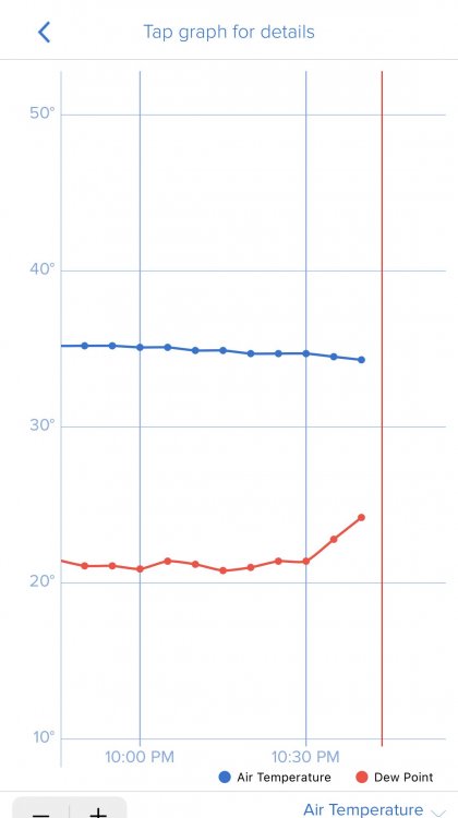
.png.bc698aab604e599d312f99eae756c80b.png)
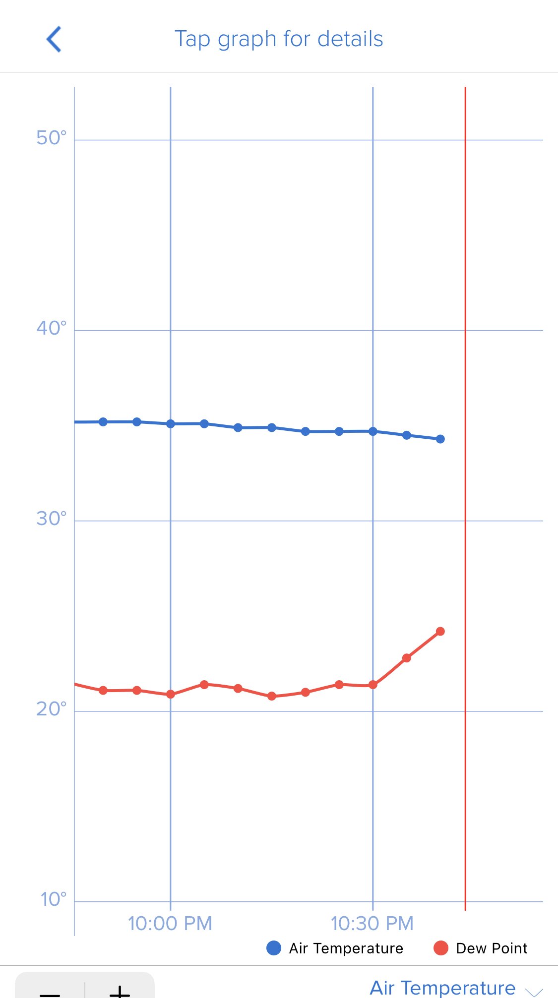
2/6/-2/7 Snow Threat
in Southeastern States
Posted
Weirdly too, the 3K had slightly higher totals in areas where the 12k cut. I can’t recall too many times where I’ve seen that.