
BooneWX
-
Posts
1,320 -
Joined
-
Last visited
Content Type
Profiles
Blogs
Forums
American Weather
Media Demo
Store
Gallery
Posts posted by BooneWX
-
-
Temp finally dipped to 31.6, I think skies have cleared just a tad here which is helping
-
Anybody know where I can find an anchored high and a gulf low??
-
 2
2
-
-
Yep I agree. I don’t think there’s going to be much to show for this storm. My DP and temps already match at 32. I don’t see us getting lower than 32 at any point tonight now.
-
1
-
-
First band is about to exit but it was absolute paste there for a bit
-
1
-
-
Stiff ENE breeze, dewpoint near 20, temp: 39, deck lowering. Lets reel this in.
-
1
-
-
Haven’t looked at the models very much but it smells like snow
-
1
-
-
Installed some garden lights this afternoon and even though the temperature shot up to 41, it was difficult to get the stakes all the way down. Hopefully that’s a good sign for accumulation. I’d like to make the most out of the initial burst of snow that I can.
-
My wet bulb is 34. Not optimal.
-
1
-
-
Made it up to around 39 and clouds are rolling in thick in Burke. Filtered sunshine through high clouds for now but I can see a lower deck in the distance.
-
Were going to torch without some cloud cover soon
-
1
-
-
17 minutes ago, Disc said:
.thumb.png.eab1f86c43e2711237aa3b0b13d7e0f1.png)
5” in Mt Airy is bullish. I’d think more sleet would cut that down but then again, maybe it stays on the colder trend.
-
1
-
-
In-situ cads seem to always underperform but I also can’t recall the last time I saw an ice storm signal like this.
-
Thread launched
-
Time for the thread!
-
1
-
-
Canadian sticking to its guns. Verbatim it would be an inch of frz rain on the i40 corridor from Asheville to the triad and just north of the triangle. Sleet fest just north of there.
-
Weird. Looks a little warmer at the surface but way more ice this run on the 3K. Would love to see it trend towards sleet and a touch of snow, but if my only option is 31 and rain, I’ll pass and take 33 and rain.
-
1
-
-
A dry slot could be deadly for the escarpment. It rarely works out to be completely dry. With the upslope flow, that’s a recipe for drizzle/light frz rain in 30-31 temps.
-
1 hour ago, Blue_Ridge_Escarpment said:
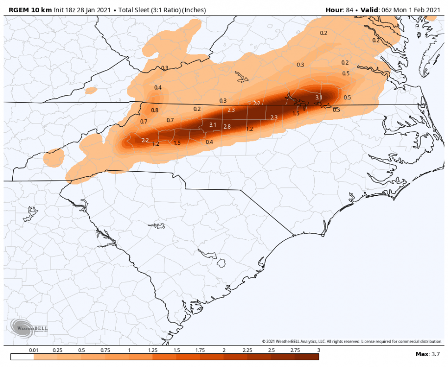
inch of snow, inch of sleet and a quarter inch of ice. Snow miser sandwich.
-
1
-
-
24 minutes ago, wncsnow said:
Looks like we will have just enough cold air in the northeast to keep us from torching later next week.
Disappointing honestly. I’d gladly trade in these paltry chances and seasonal temps for temps pushing 80 and golf.
-
1
-
-
16 minutes ago, wncsnow said:
Its starting to look like the GFS
.thumb.png.49a4dadfab36e0714777390a5148c8a3.png)
.thumb.png.7a393664a925e13aba4369d88c29ff4a.png)
Cash me out for winter! Hope we have some severe weather to track soon.
-
6 hours ago, Blue_Ridge_Escarpment said:
Trending towards more ice. Not good at all
If it’s only a shot at ice, I’d rather it be a cold rain.
-
1
-
-
48 minutes ago, Jmoon said:
I know what you mean. I'm in danieltown. It's been tough sledding for us in the foothills the last 2 winters since the dec 2018 storm. I had a feeling we would pay for that storm because it was such a good snowstorm for us. Hopefully Things will turn around for us soon. We're sure do a decent snowstorm around here.
I literally thought the same thing yesterday watching the model runs come in. We were too fortunate with that storm! It’s almost as if we used up all of our good-will with Mother Nature for the foreseeable future when she decided to gift us with 1-2 ft. I still look back at that event thread and reminisce
 .
.
-
1
-
-
5 minutes ago, wncsnow said:
Not a bad run but the low has been trending north slightly the past few runs. Need that confluence to be stronger and of course having the CAD high a bit stronger wouldn't hurt.
Kinda surprised the CAD didn’t have a stronger signal given the dewpoints below zero in the NE.
-
Euro says not so fast! Still would like to see that high a further south, but I’m not going to let global thermals for CAD sway me 100+ hours out.
.png.9fcb57bf1fba76943b07ed540a68f7db.png)

.png.a51d6091a5c8de2ed303e9ce64ce1b73.png)
.png.1e927af1a95811cb297f84e25b5e9222.png)
2020/2021 Fall/Winter Mountain thread
in Southeastern States
Posted
Have the skies cleared ahead of this second batch?? Temp at my location is dropping like a rock now.