
BooneWX
-
Posts
1,320 -
Joined
-
Last visited
Content Type
Profiles
Blogs
Forums
American Weather
Media Demo
Store
Gallery
Posts posted by BooneWX
-
-
Southeast page lurker here: I’d ease up on calling it a “bust.” The core of the wind is still well offshore and I’m afraid some of you are about to find out just how little wind is required to do damage when you’ve already had a ton of rain. Even 30-45 mph sustained with higher gusts will be a huge issue inland. Anyways. Carry on.
-
 1
1
-
 2
2
-
-
Holy moly that last frame on the IR.
-
A historic day and not in a good way for western NC. I fear the Catawba and Johns River areas will worsen with this line soon.
-
1
-
-
Reed Timmer chasing in our region tomorrow….

-
-
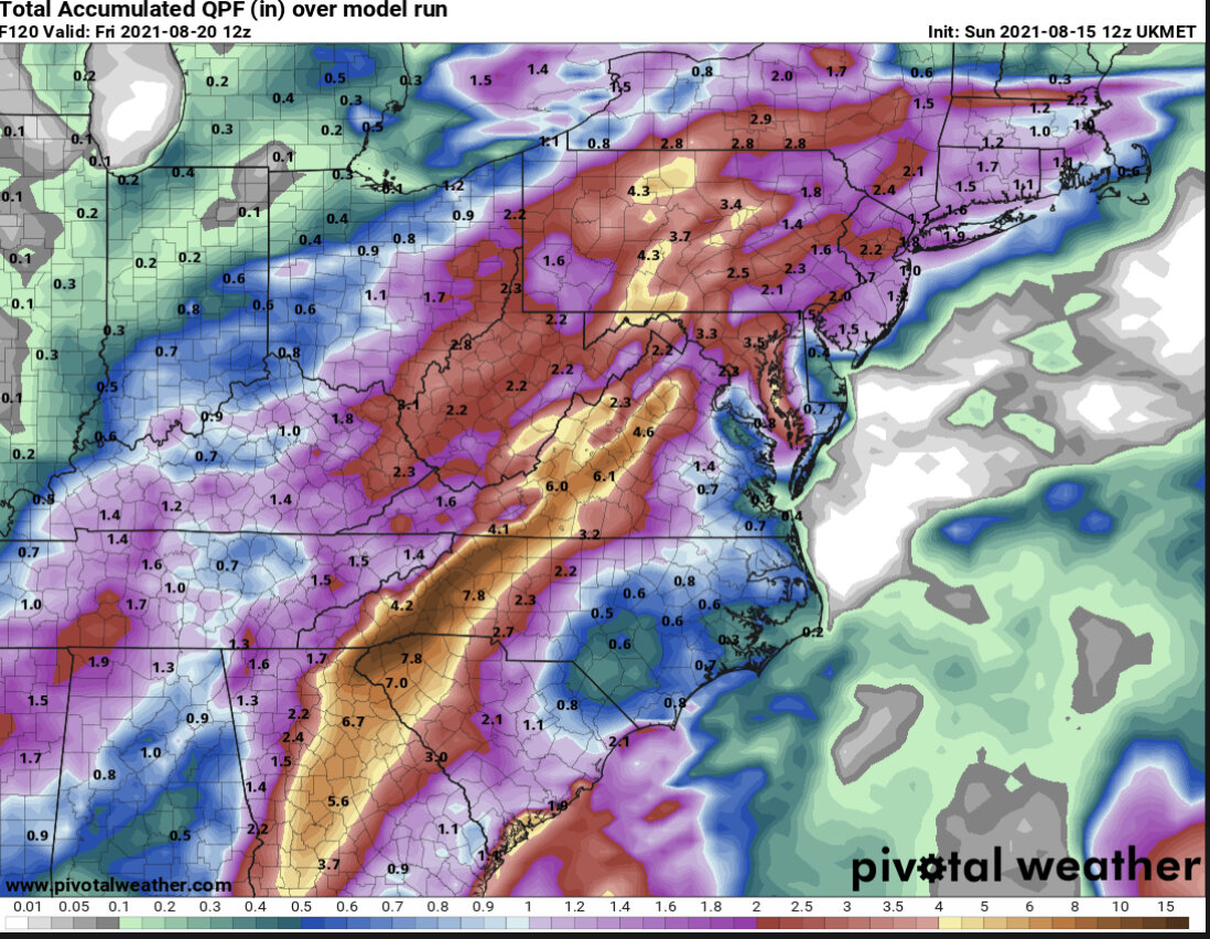
Over 3 inches of rain the last few days here in Burke. I’m afraid Fred rising from the dead is going to spell trouble for upslope and foothill areas.
-
1
-
-
Looks like she’s jogging due north again…
-
1
-
-
My tempest station has recorded 21 days since the start of the year that have been rainy or featured rainfall and it’s only Feb 23rd. Many of those days temps were in the 30s or low 40s. This pattern has been brutal and at this point I’d sacrifice any shot at March snow if it meant a spring with at least semi warm temps and some sunshine. Bring it on!
-
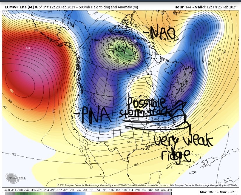
Seems like as long as we have a weak SER, we’re sitting in a pattern that’ll be hard pressed to produce snow and will keep producing many cold rains with occasional light icing opportunities. If the cold air can’t be dominant, let’s just hope the SER becomes robust and lets rock into March with 70s and dry weather.
-
5
-
 1
1
-
 1
1
-
-
1 hour ago, WinstonSalemArlington said:
Well, at least the Southeast Ridge is neutered
I’m rooting for the GFS Ens in that range
-
3 minutes ago, WinstonSalemArlington said:
Huh?
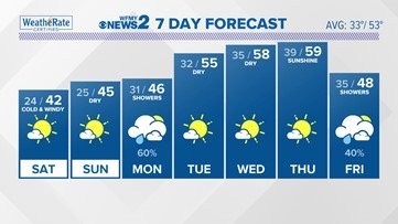
I stand corrected, not 70, but still close to 60 multiple days. Sun angle, ground temps, no cold air. 0/3.
-
It’s going to take a serious push of cold air for it to be anything less than a 36 degree snowfall and wet grass. Temps are near 70 or higher forum wide mid week.
-
1
-
1
-
-
This is likely a cold rain for anyone under 2500 ft
-
1
-
-
2 minutes ago, frazdaddy said:
lol, 12 z GFS Next weekend @189. Here we go again.
Marginal, rate driven snowfall. Tell me where I’ve been sold this snake oil before lol. Why can’t spring just get here.
-
2
-
-
5 minutes ago, wncsnow said:
Lesson- Never toss models that show the least snowy or icy solutions, even 4 hours before start time
I’ll gladly eat my crow. Happy they were right on this one! I want a record breaking SER for Spring and some thunderstorms to track now.
-
32.2 and dropping. This heavy batch might dip me below freezing.
-
Up 6 degrees in 45 min
-
Just now, AirNelson39 said:
That’s crazy! I’m in southern Caldwell east of 321 and I’m at 34.2/26.7That’s a wild difference but we kinda sit in a small valley between two creeks. I consistently run 3-4 degrees below the airport each night. It’s a weird little microclimate.
-
3 minutes ago, WXNewton said:
There are several stations in N.Catawba already reading 31.2-31.8. Clouds are starting to roll in so I expect that to jump up some in the next hour. 5-7 mph stiff NNE wind.
I’m down to 29.8 just to the west of Hickory
-
2
-
-
1 minute ago, WXNewton said:
What to? So funny, was talking about the models running too warm today and now said the trend was to warm us up more. LOL!!
Not sure. He said he would release a final call at 11, but seemed borderline unconcerned about any area south of Wilkes.
-
Brad P cutting totals
-
1
-
-
I’d probably toss models 4 hrs ahead of start time
-
1
-
-
31.8 here...wasn’t supposed to dip below 32 until 2 am.
-
1
-
-
2021 Spring/ Summer Mountains thread
in Southeastern States
Posted
Decided to take a trip to the NE forum a few moments ago and they’ve all already “canceled” the storm because they haven’t had any strong winds or damage at this point. The core is still 50 miles+ out to sea .
.