

BlunderStorm
-
Posts
1,122 -
Joined
-
Last visited
Content Type
Profiles
Blogs
Forums
American Weather
Media Demo
Store
Gallery
Everything posted by BlunderStorm
-
Currently in what would appear to be Diego's last hurrah here. It's falling heavily. I'm rooting for this to go on for as long as possible.
-
Snow showers are picking up and coming in from the NE.
-

Winter 'Tis the Season Banter Thread 2018-2019
BlunderStorm replied to Carvers Gap's topic in Tennessee Valley
Well I would like to know the conditions that resulted in the downslope occurring. In most storms this is not an issue. In order to do that I would have analyze the storm and look for, understand, and come up with conclusions with the data. Here is the incomplete possibly flawed understanding I have of what occurred. Winds at the surface were coming from the northeast while winds further up would have been coming from the south. Beartown Mountain (part of Clinch Mountain) at a height of 4688ft presents a barrier for the lower levels of the storm almost reaching the 850mb level. From my understand the mountain took the immense amount of moisture from the storm and channeled it up it's slope causing orographic lift. This resulted in a lot of condensation that released a ton of latent heat into the air. Because the air was coming from the south at the 850 level the winds continued beyond the mountain spilling into the Clinch river valley just in time for the storm's arrival up here. This layer of warm air however critical to the amount of snow accumulation would be shallow due to the stubborn cold NE winds beneath it at the surface and only partially melt the snow crystals resulting in graupel. This I believe is a good theory as to how this occurred however numerous storms have taken a similar track and not resulted in this. This I believe in part was caused by the exact circumstances of this event which I have no idea of knowing and also in part by the warmer than modeled air the storm brought up the valley. It may not have been able to change the precipitation type here on it's own this far up but it certainly could have helped the downslope effect. Also of note early into the event I faced my 1st less influential enemy virga. I don't have any precise answer for that but my reasoning is the winds from the NE brought with it dryer air near the surface that would keep the relative humidity tempered down. In total it took almost 3 hours of moistening the atmospheric column between seeing snow on radar over me to see light precip reaching the ground from 9 to midnight. Anyway after many hours as the storm pivoted winds changed direction and the downslope effect weakened resulting in me making a full transition to snow in the late morning and early afternoon before switching back to a mix near the end of the event at the warmest time of the day when it was 33. Even with all this chaos and factors working against me I still got some snow though. Wow. -
Winter 'Tis the Season Banter Thread 2018-2019
BlunderStorm replied to Carvers Gap's topic in Tennessee Valley
Yeah, it was really rough to watch. There is nothing more infuriating than looking out for a storm for 10 days only to be stuck in graupel for hours surrounded on all sides by heavy snow just a few miles away. With that said I at least I got some solace at the end. John, I know everyone has said it and including you yourself but to emphasize... It is just December 9th. We are still weeks away from peak climatology and weather patterns as far as I know are looking fairly favorable. We will get ours. For me I'm still weather hungry and already looking ahead. A bust won't put me down for long. The time without a 6 inch snow streak continues but it's days may be numbered. -
Well looks like the temperatures to support snow are about shot. I've got a mix of light snow and drizzle at 33. Thankfully it's only down from here so maybe I see things shift back. Looks like I'm locked into the comma as it pivots as I was hoping and there seems to be a heavier wave of snow forming in Scott county. I would say accumulations have topped out at 2.4. though I'm not sure if that's it.
-
It's just a light snow but at least it's still falling. The temperature has finally inched above freezing and will probably continue to warm for another hour.
-
December 8-10 Storm Discussion
BlunderStorm replied to Holston_River_Rambler's topic in Tennessee Valley
2.2 inches. I'm thinking 3 inches in total when all is said and done. I would say it it is still falling at a moderate clip and the temperature is just at freezing. -
December 8-10 Storm Discussion
BlunderStorm replied to Holston_River_Rambler's topic in Tennessee Valley
The comma head is getting close to spinning around here. It could be close. The least that can be said is the snow seems to be moving out slower and slower the further up the valley it goes especially on the western side. -
It's 32 and heavy snow is coming down hard. No more mixing, YES!
-
Well, right now the weather is in it's finest hour up here. It's making a final push against the downslope. I just got a heavy burst of almost entirely snow. So it's not a total loss.
-
Had a friend who lives just 3 miles up the road in Swords Creek Report more than 8 inches. It's transitioned to mostly snow now but I'm not sure for how long as the temperature has been rising. EDIT: Another one west of me near Haysi is reporting 4 and 1/2 inches.
-
Wow, I was just outside looking to my north and saw a wall of white half a mile away. This isn't the kind of white fade you see that is gradual it is almost instant. I believe I see an extremely sharp gradient between wintry mix and 100% heavy wet snowfall. All it has to do is advance half a mile south and I could finally, finally, see a transition. Weather variation doesn't get much more localized than this folks.
-
I can now confirm 1.3 inches of frozen slop. Let's get to 2 inches baby!
-
December 8-10 Storm Discussion
BlunderStorm replied to Holston_River_Rambler's topic in Tennessee Valley
Beggars can't be choosers and we're beggars. Funfact my account is named BlunderStorm for a reason. It was to give good irony to my condition. Today my name can be taken literally. Until the next snowstorm hits and it's a win here I think I'll put this as my profile picture. It's fun using garfield in my profile picture because he is so versatile in that he fits in almost any situation.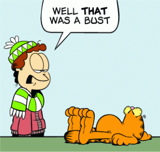
-
Admittably things have got a little better over many hours in terms of the snowfall mixed it. This storm just made model watching a lot less fun. It had to find a way for it not to snow here and the answer was downslope. Looking back to Winter Storm Jonas it seems like I had a similar issue with incessant sleet after a quick burst of snow. It did this for many hours and I could not figure out why. It would seem I finally discovered the biggest weakness in my micro-climate towards getting a snowstorm. The Nam 3km and HRRR nailed this effect on the head and deserve credit for depicting this area of graupel. Global models and mid range models failed to pick up on the "screw over zone" because their resolution was too low. With that said even the short range models failed to show the true extent of this mess. My only hope towards any redemption of this tragedy is if the 2nd wave of this system is stronger than forecast and further north than forecast. In it's case the winds have shifted direction and no longer give me downslope of epic scale. Yeah, I really took this one on the chin and it's driving me up a wall. I mean I'm happy for you guys in TRI but at the same time I'm thinking..."shoulda been mine dang it!" haha.
-
The graupel train just keeps on rolling. Regardless I still have a solid inch of miscellaneous frozen precipitation.
-
Graupel...so much graupel. 27 and graupel. Oh sure there are a few snowflakes but they won't amount to anything. I can visibly see the changeover to all snow. It's just a mile or two away just sitting there like a white curtain. It's so definitively pronounced. I would be shocked if it did switch over here though.
-
How can a mountain generate this much heat? Disregard the surface temperature I guess. The worst part of this is cooling from precip doesn't help because the wind direction always introduces more warmth. I'm never switching over. It is now daytime and the worst part is I can virtually see the whiteout conditions heading towards Big A from my house.
-
I dozed off. I'm still at the mercy of Clinch Mountain. It is 27 degrees and graupel is still falling. The road looks terrible. At this point I've given up hope of anything changing this over. Power is still on at least. What a disappointment.
-
December 8-10 Storm Discussion
BlunderStorm replied to Holston_River_Rambler's topic in Tennessee Valley
I just did another check outside. It has entirely stopped with the freezing rain. What I'm looking at out there isn't even sleet it's graupel. The snowflakes are only partially getting melted. Just one little boost that's all I need to jump start my snow totals. Also I apologize if I'm posting too much or not contributing enough to the general conversation. I'm going to limit my yammering. -
December 8-10 Storm Discussion
BlunderStorm replied to Holston_River_Rambler's topic in Tennessee Valley
I can't speak for anyone else but I believe the 3km has handled this very well for me. -
December 8-10 Storm Discussion
BlunderStorm replied to Holston_River_Rambler's topic in Tennessee Valley
Looks like another wave of heavier snow is heading up this way in the next hour. Maybe this is what I need to finally fully transition. This downslope effect is going to be a chronic feature of this storm. How strong it is, is another thing. I'm sure if we had posters in Damascus or up along south Holston you'd hear the same. I'm not thinking complete bust. I'm considering dozing off but I don't want to miss a potential change over. -
December 8-10 Storm Discussion
BlunderStorm replied to Holston_River_Rambler's topic in Tennessee Valley
Progress was being made but it was painfully slow. Behind frontlines allegiances sway and support for the war is limited. In some cases riots occurred resulting in sways towards support of the rain. It would be a long war of attrition. (To be continued) -
December 8-10 Storm Discussion
BlunderStorm replied to Holston_River_Rambler's topic in Tennessee Valley
Really glad the precipitation type isn't rocket science for some folks. Hope you folks down there hold on to that! -
December 8-10 Storm Discussion
BlunderStorm replied to Holston_River_Rambler's topic in Tennessee Valley
I don't know how to say this but...It's back to snow by some miracle all in the short time span of 10 minutes! I don't know how, I don't know why, I don't know for how long but the downslope has toned it down some. Welp, I'm not forgetting this one. You see I didn't cliff dive I accepted my fate and said go on mock me. Instead in the most twisted way it mocked me in that it is now a pure heavy snowfall with some inch in diameter flakes. Of course in 15 mins I'm sure It'll be back to roasting anything frozen that dare falls here within a 5 mile radius. UPDATE: 2 minutes later it's back to a mix. xD


