BlunderStorm
-
Posts
1,122 -
Joined
-
Last visited
Content Type
Profiles
Blogs
Forums
American Weather
Media Demo
Store
Gallery
Everything posted by BlunderStorm
-

December 8-10 Storm Discussion
BlunderStorm replied to Holston_River_Rambler's topic in Tennessee Valley
Ouch, looks great but for some reason warm air gets trapped in the clinch river valley and I never transition to full snow. Normally I would dismiss this but I've seen this supported run after run for an entire day. -
December 8-10 Storm Discussion
BlunderStorm replied to Holston_River_Rambler's topic in Tennessee Valley
So glad to see you guys getting snow. I have a feeling this storm is going to be one to remember. -
December 8-10 Storm Discussion
BlunderStorm replied to Holston_River_Rambler's topic in Tennessee Valley
Looks like the snow showers depicted on radar have expanded from just north of Dyersburg to BNA. -
December 8-10 Storm Discussion
BlunderStorm replied to Holston_River_Rambler's topic in Tennessee Valley
Ohh... you guys are going to love the Euro tonight! I don't have the space for an image so go check it out yourself haha. https://weather.us/model-charts/euro/2018120800/819-w-373-n/significant-weather/20181208-0300z.html And Touchdown SWVA! And the Extra Point is Good! The game is tied 30 to 30 and will go into overtime. With the Euro re-affirming I'm still in the running for a winter storm since the tough runs a day ago I can stay excited about this. The suppression let up thank goodness. Of course now it's less than 24 hours until the start of this thing. Can things go wrong for us including myself ? Yes and I acknowledge that. It's time for the models to be judged. -
December 8-10 Storm Discussion
BlunderStorm replied to Holston_River_Rambler's topic in Tennessee Valley
On the first of the nowcast side of things I'm seeing some snow showers west of Nashville. I wonder if that could translate to anything for them in the early morning. -
December 8-10 Storm Discussion
BlunderStorm replied to Holston_River_Rambler's topic in Tennessee Valley
When will NWS Morristown release an update? I'd think if the European held on to the 12z or improved on it that it would be enough to warrant a winter storm warning in effect for our region. -
December 8-10 Storm Discussion
BlunderStorm replied to Holston_River_Rambler's topic in Tennessee Valley
CMC (fwiw) this late in the game looks great and is improved from 12z. This is probably the last time it will be worth a mention. The HRDPS lays down the hammer even harder than it did last time but gives Russell county the middle finger for no apparent reason other than *BlunderStorm wants it to snow here*. It is finally time for the FV3 and Euro to cap us off for the night. As a bonus check out the RAP model on pivotal or wherever you view it. Apparently at 3z it runs 39 hours instead of the usual 21 hours. It's lackluster up here but good for Tennessee leaving a surprise for west tenn. -
December 8-10 Storm Discussion
BlunderStorm replied to Holston_River_Rambler's topic in Tennessee Valley
and...you would be entirely right. -
December 8-10 Storm Discussion
BlunderStorm replied to Holston_River_Rambler's topic in Tennessee Valley
Anyway, the ICON looks really good for SWVA and TRI. It also comes with a nice surprise a little later for Middle Tennessee and the Plateau. I haven't seen the snow totals but it heavily resembles 18z. Next comes the GFS and CMC. EDIT on an added note the HRDPS (the high-res RGEM) is running as well though it only processes a map for SWVA, SEKY, and NETN. -
December 8-10 Storm Discussion
BlunderStorm replied to Holston_River_Rambler's topic in Tennessee Valley
Heh heh, only for the next potential storm next weekend to add insult to injury! -
December 8-10 Storm Discussion
BlunderStorm replied to Holston_River_Rambler's topic in Tennessee Valley
That's the clown version of course. If you want a more honest snow total check pivotals snow depth map. It always tempers my expectations. However, I believe it was a day or two ago I overheard on the SE forum a meteorologist talking about temperatures at 850mb and 700mb and how modeling will often depict a heavy snow as sleet if a layer in the atmosphere is 33. When in all actuality the snow survives the conditions and continues to fall. -
December 8-10 Storm Discussion
BlunderStorm replied to Holston_River_Rambler's topic in Tennessee Valley
The RGEM is once again a heavy wet mess with the most confusing precipitation map you can conceive of. This is the run that if your positioned well is epic but knocks down your trees and leaves you without power for a week. The low looks further north on it and less consolidated. If your in southern Tennessee you don't want this solution. As for me on this run I get stuck with some overlying warm air over the clinch river valley and get "iced over real gud." Models aren't perfect so I doubt this would exclusively apply to me so it looks pretty fun. -
December 8-10 Storm Discussion
BlunderStorm replied to Holston_River_Rambler's topic in Tennessee Valley
I've got the storm (famous last words) and now I'm hoping for the storm to do as hard of a pivot as possible on modeling. If your in southern Tennessee the 3km this time around was a little bit of a letdown but not too bad. I'm calling for 4-7 in Honaker but I would sway away from prediction outside of my town with my limited knowledge. I hope 0z at least continues the status quo. For the past 2 days in a row 0z has been a pain and 12z has been a blessing. Let's hope we break that trend tonight. NEXT UP: RGEM and ICON -
December 8-10 Storm Discussion
BlunderStorm replied to Holston_River_Rambler's topic in Tennessee Valley
The NAM 3km starts off a little warmer than the 12km though after a quick bump of sleet/rain for an hour it transitions to all snow. EDIT: Warmer temperatures in the late morning begin to prevail and areas shift back to rain/ice/sleet. As the low begins to pivot NE, SWVA holds on to light to moderate snow for a few more hours after things calm down a little in NETN I'm not sure why the upper levels are such a mess after the low is to our SE. The event looks more limited in duration compared to the 12km for some areas. -
December 8-10 Storm Discussion
BlunderStorm replied to Holston_River_Rambler's topic in Tennessee Valley
The precipitation shield looks to be 1 to 2 counties further north, the back edge of the storm looks a little less robust, temperatures seem to be 1 or 2 degrees colder, and the low itself is little quicker as well. EDIT: The precipitation does not seem to be expanded much more to the north as later in the run the 18z made up the difference compared to 0z. The next play of the drive is the NAM 3km version. -
December 8-10 Storm Discussion
BlunderStorm replied to Holston_River_Rambler's topic in Tennessee Valley
Man it was radio silence on the weather channel tonight west of the blue ridge. You'd think there'd be enough of us to at least warrant a mention. -
December 8-10 Storm Discussion
BlunderStorm replied to Holston_River_Rambler's topic in Tennessee Valley
How much further do you guys think the NW trend will go? I for one want to be as far away from the fringe as possible. -
Winter 'Tis the Season Banter Thread 2018-2019
BlunderStorm replied to Carvers Gap's topic in Tennessee Valley
I'm liking your new profile photo haha. -
December 8-10 Storm Discussion
BlunderStorm replied to Holston_River_Rambler's topic in Tennessee Valley
It's looking like snow has become increasingly likely in Pigeon Forge for Sunday morning. Now with that said there are some models that keep the freezing temperatures in the tri-cities (Kingsport, Johnson City, Bristol) and north of there without a flake falling down there. I believe the later you leave on Sunday morning the more likely you are to get caught in snow. With that said you mention taking I-75 home so if that is the case as you drive south towards Chattanooga you should be safe from the threat. -
December 8-10 Storm Discussion
BlunderStorm replied to Holston_River_Rambler's topic in Tennessee Valley
Oh yeah, I noticed too I'd be willing to bet we'd have some thundersnow with that. That is something I have never witnessed/heard. Although to tell you the truth I'm just thankful I have precipitation shown over me at this point. -
December 8-10 Storm Discussion
BlunderStorm replied to Holston_River_Rambler's topic in Tennessee Valley
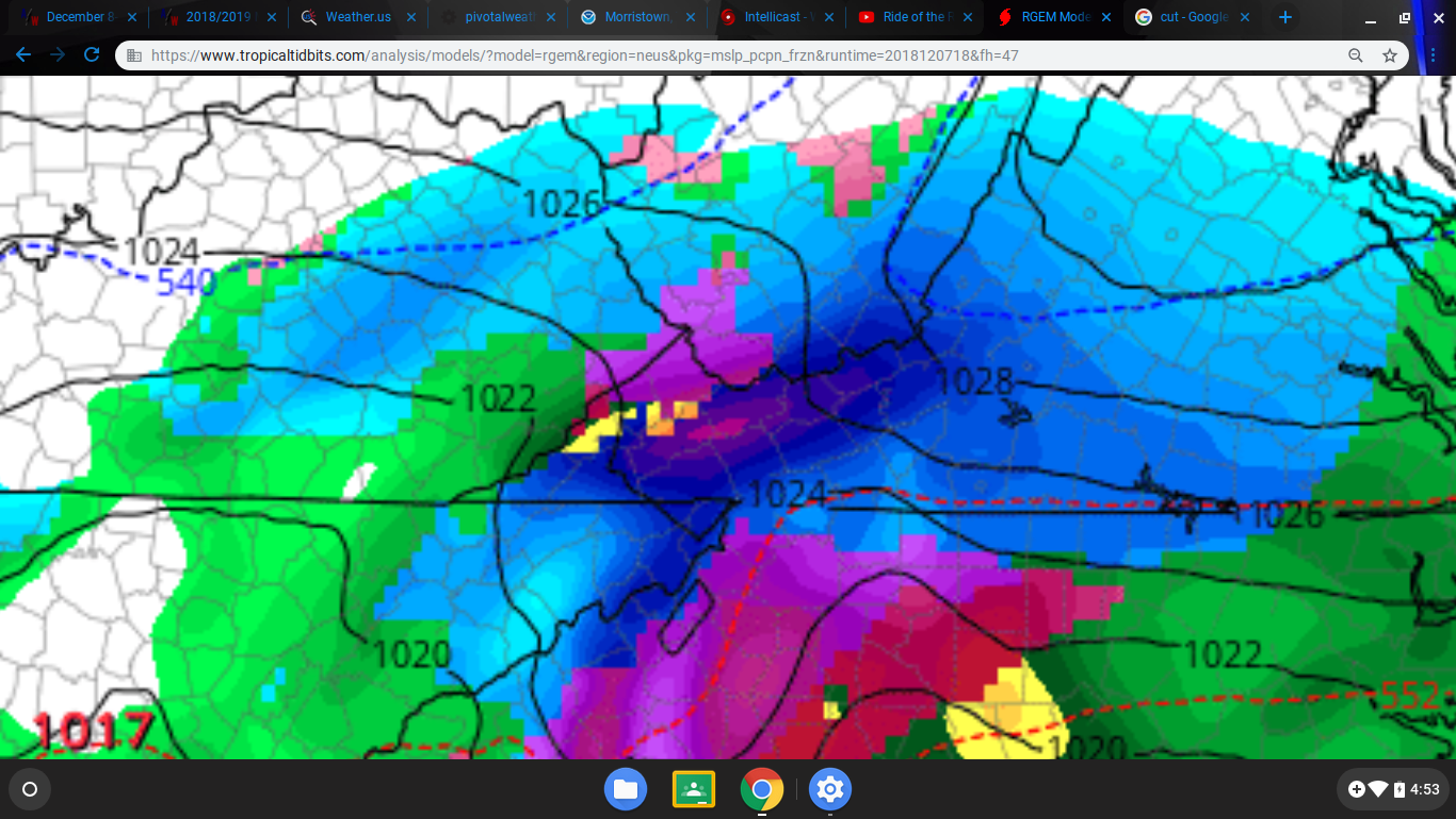
I dream of being under snowfall rates that great... I am put under an artillery bombardment on the RGEM!
-
December 8-10 Storm Discussion
BlunderStorm replied to Holston_River_Rambler's topic in Tennessee Valley
1) with the exception of warnings being declared in NE TN mountain counties. -
Winter 'Tis the Season Banter Thread 2018-2019
BlunderStorm replied to Carvers Gap's topic in Tennessee Valley
The 12z suite saving me from cliffdiving visualized. lol. -
December 8-10 Storm Discussion
BlunderStorm replied to Holston_River_Rambler's topic in Tennessee Valley
As Holston River Rambler said at the very beginning of this thread... "Fate often spares an undoomed man, if his courage is good." --Beowulf, Book VIII, lines 572-3. -
December 8-10 Storm Discussion
BlunderStorm replied to Holston_River_Rambler's topic in Tennessee Valley
I'm already disappointed. I have little to no digital snow to lose so hey...It can only go up from here. Last night I was boiling red and now I have an honest smile on my face. You guys go check out the canadian. (fwiw not expecting even 1/4th of that) EDIT: Oh what do you know the ICON trended NW and is colder! That's the last model I expected to cooperate.