WarmNose
-
Posts
1,125 -
Joined
-
Last visited
Content Type
Profiles
Blogs
Forums
American Weather
Media Demo
Store
Gallery
Everything posted by WarmNose
-
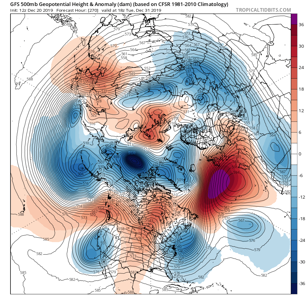
Yowzer! The return of the Arctic. What a vortex this is forecasted to be
-
Curious to see where this leads. Looks like a major arctic ice addition is in the cards for the end of the year. Healthy PV

-
I’m just glad the server works here
-
It’s hilarious the snow goobers evacuate the thread for the main winter months but are back in April for one last rug pull
-
Hard to believe anything the GEFS does good in the long range (I.e Snowfall Maps) simply because it’s so block happy and it never materializes
-
Worst winter ever. I’ve seen some bad ones, but this takes the cake. Its hot today even by spring standards. We suck at snow. It will never snow again. The sky is falling. Magnetic north is shifting the wrong direction. We might as well live in South Florida. Winter is gone and never coming back
-
No. I think he’s saying this winter is exceptionally sh*tty
-
I keep hearing the argument that we shouldn’t give up on winter yet because it’s not even halfway over but modeling goes out to 15 days so technically it’s almost over. I know you can’t usually trust long range modeling but when it shows heat you can make an exception and count on it. With that said I still wouldn’t toss the idea of one more thread the needle event east of the mountains. Brick will probably add at least another 6” before this exhausting winter comes to s close
-
Man this winter rocks! You can’t even question the Madokie Niño in the main thread without someone getting bent out of shape! There’s so much to track it’s insane. Literally haven’t slept in weeks. You can tilt your head sideways and look at 500mb maps all you want but it won’t change the fact that this winter IS and CONTINUES TO BE an epic bust. Congratulations everyone. Well done
-
Sorry your thread got the X, Orangeburg im feeling pretty good about the first of February. It was a pretty good premature call imo. Also pretty good call to take it down. I’m torn
-
This system is barely crawling. Anybody in Tangier? Looks like it’s putting down pretty good
-
“If only it were January” January: Rain “if only we could get one of those 1040+ HP’s” 1040+HP: Rain i think it’s best we just quit pretending we know more than we really do about the weather. There is no recipe for success when it comes to weather, only snow and rain. Success and failure. And we fail more times than not
-
My standing water is riddled with mosquitos and bullfrogs
-
Well you already got flurries this winter so you should be near that
-
09’ redux? Sign me up!
-
I’m going to go ahead and drop some chlorine in the pool skimmer tomorrow afternoon. Won’t be long and I want it to be ready. The birds are on the move and the pollen won’t be far behind.
-
While It sucks being just south of 85 in the upstate, we do at least get a couple inches when places throughout NC get absolutely smoked. It could be worse. A little further to my south is Greenwood SC and their climo is probably as bad or worse than Miami Florida
-
If you follow a winter weather forum, there’s a 100% chance you are a snow weenie deep down inside. 100%. People show heartache in their own ways. They’re projecting. There’s a lot of bitterness built up for years and years of disappointment. Missing out on the “big one”. Insanity, really. Having lived where they live for most, if not all, of their lives and every year they somehow think things will be different. Time marches on.
-
It always makes me feel a little better when I’m situated north of the southernmost warned and advised areas. Wouldn’t be the first time the wheels have come off, though. (Im)Patiently waiting on that wedge to settle in
-
Don’t tell Brick
-
Take pictures of your snow. Congrats ahead of time. Many hours spent tracking this one. You deserve it
-
I don’t even know how to get measurable snow anymore. Clippers?
-
Reading through the forum, It’s easy to tell who isn’t getting snow tomorrow. Me being one of them
-
We hold out hope, but those of us who can read models know what’s coming. You can’t wishcast 6” of snow on the ground. Especially in the south
-
Me and Mack put our hearts and soul into this and we are about to get shut out. The wedge only works when you’ve got severe wx rolling in. Man I’m bitter. I mean I know Travelers Rest is a short drive but I like looking out the window at it. 8 straight nights staying up for the 00z Euro just to track a dud but it’s my own damn fault. It was a dud from the start. Low track over Jacksonville and we still rain. It’s hard to accept. Even in early December