eduggs
-
Posts
5,950 -
Joined
-
Last visited
Content Type
Profiles
Blogs
Forums
American Weather
Media Demo
Store
Gallery
Everything posted by eduggs
-
We do want phasing between what's left of the southern stream (ULL) and the northern stream (shortwaves embedded in the longwave trof) in the South. That initiates SLP formation along the Gulf and keeps the trof from progressively collapsing. This is more important for the mid-Atlantic, but also important for a bigger east coast event overall.
-
I'd call that ECM run a step towards the ICON. Much needed for morale. It would be great to see more ensemble support as well.
-
The 12z ECM has a little more phasing this run. The southern stream ULL tracks slightly further east, allowing a bit of energy to get to the downstream side of the trof. And then by 12z Wed there is a weak surface reflection near the panhandle of Florida. I'm happy to see this on the ECM!
-
Southern stream was further east this ECM run. Slightly more phasing. Definitely a positive development!
-
No offense was meant. But it's a little like saying a surface high can block storms or that a surface low causes a storm and precipitation. We like to almost anthropomorphize meteorological features that are actually just a reflection of the large-scale upper level atmospheric circulation and evolution.
-
Kickers are never the problem. They are (usually) a symptom of an unfavorable upper level evolution. It's a dumb term coined by people who don't know what they are talking about.
-
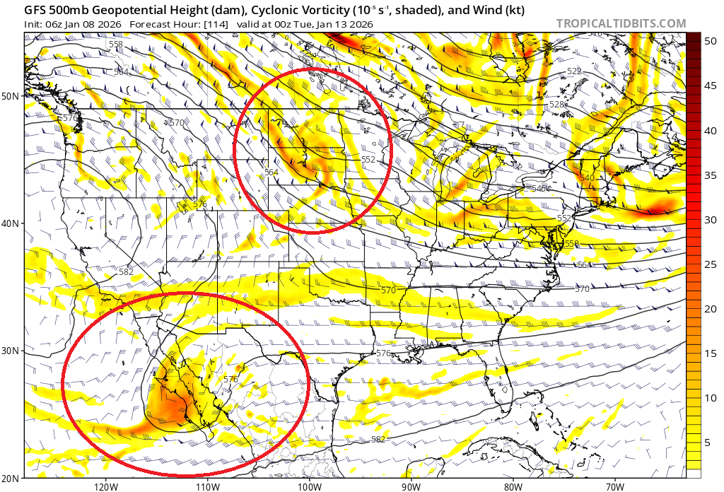
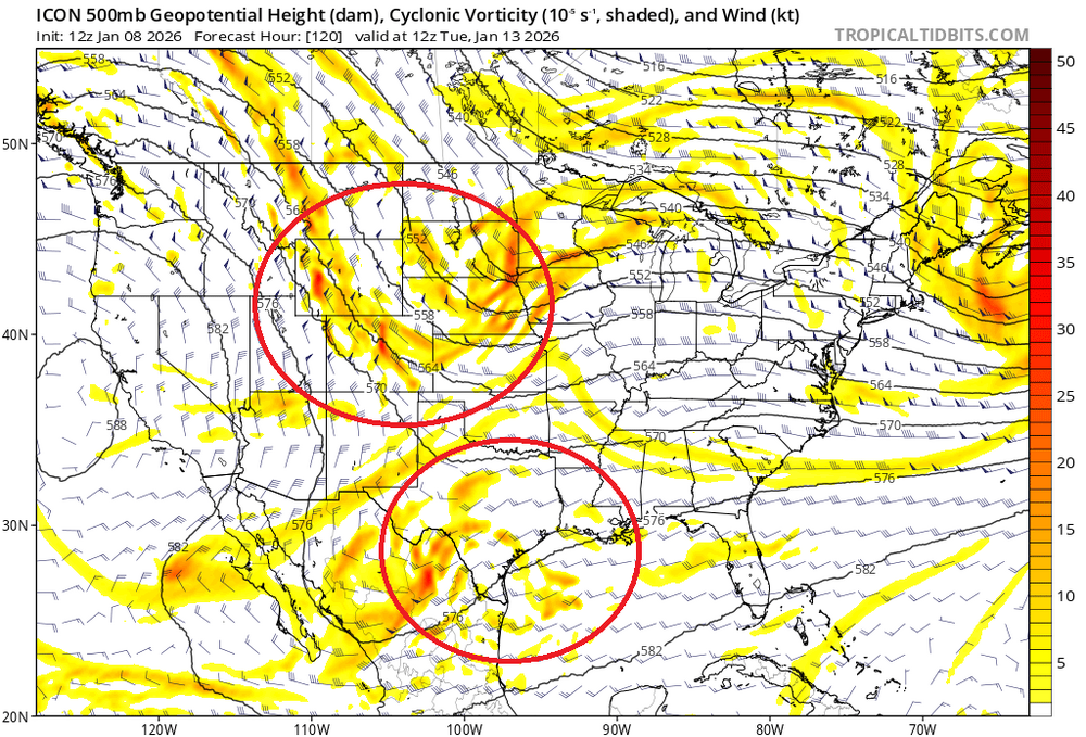
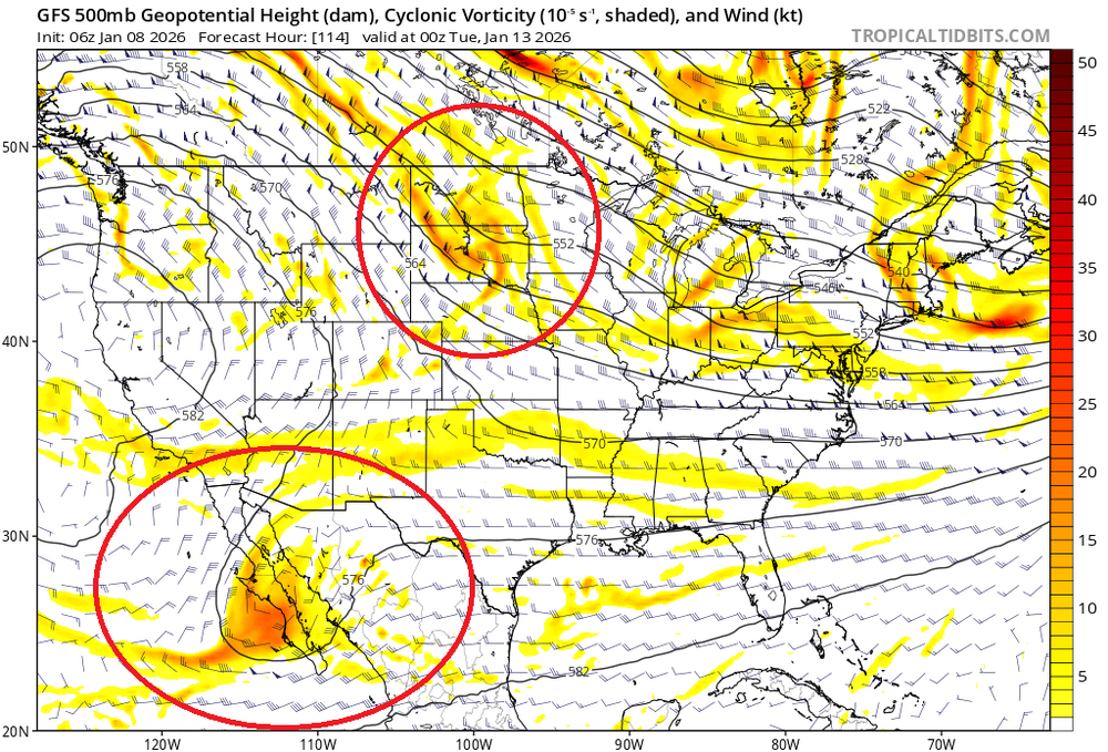
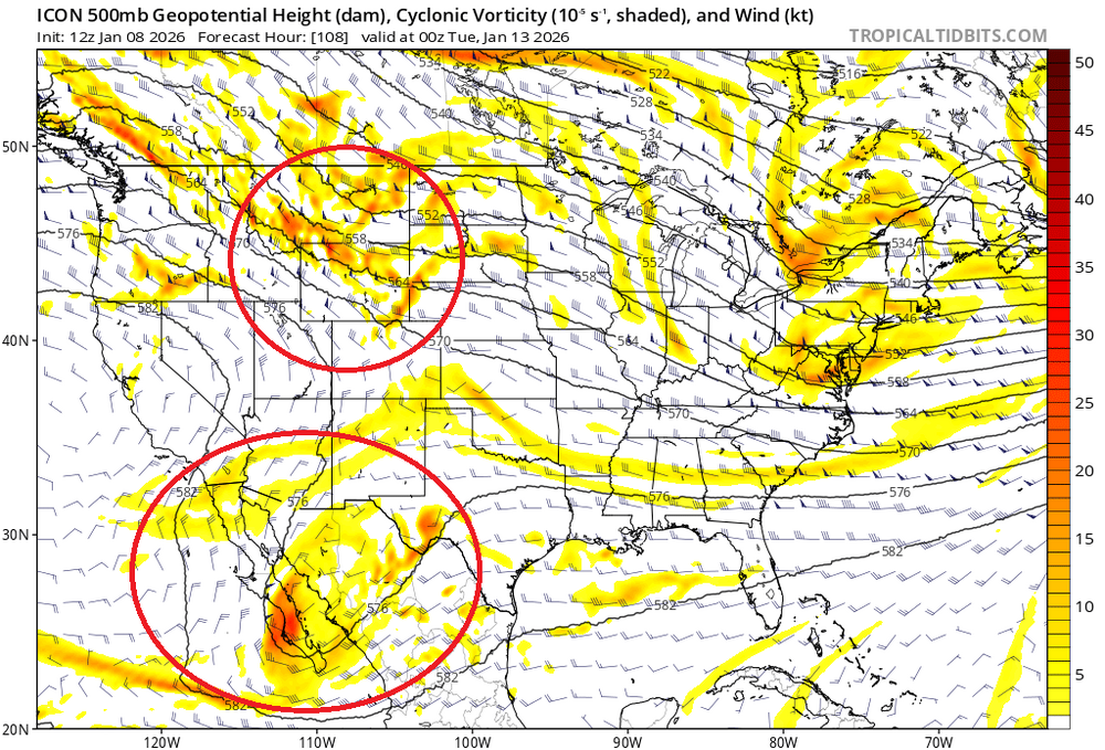
We need the ULL to be as far east as possible and the northern stream shortwave diving south to be as far west as possible. We need these to at least partially phase, so the ULL needs to be downstream of the developing longwave trof. Otherwise the trof will be positively tilted and a coastal storm is unlikely. Ensembles and AIs have been trending in the wrong direction. Only the ICON shows a successful evolution with this feature.
-
The GEFS, EPS, EC-AI, and GFS-AI have been trending away from phasing the southern stream energy, leading to an increasingly positive tilted longwave trof. That won't work here for a coastal snowstorm. None of the individual GEFS ensemble members and maybe 1 EPS member support the ICON phasing idea. We need big improvements fast.
-
If the southern US ULL doesn't at least partly phase into the longwave trof, Thurs/Fri next week will almost certainly end up with a positively tilted trof folding onto itself and the baroclinic zone well offshore as currently modeled by the GFS and ECM. The ICON is the only model that tracks the northern stream shortwave far enough west to get the ULL on the downstream (right) side of the longwave trof, allowing phasing. There are no individual GFS/ECM ensembles members that support the ICON, which is why I think it's wrong about this feature.
-
There's no reason to believe there's any better period coming out beyond the range of models.
-
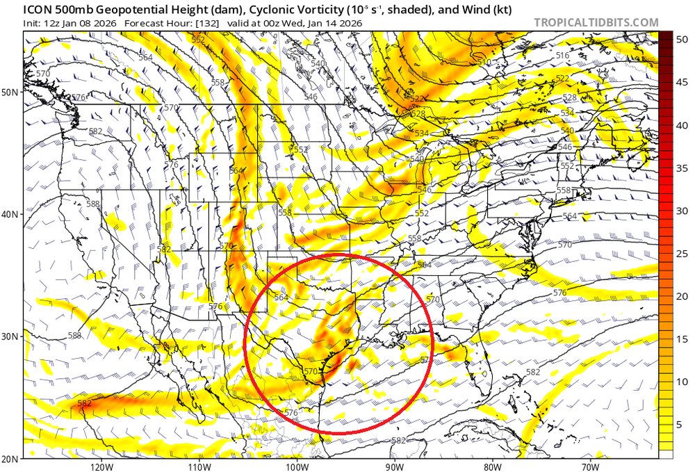
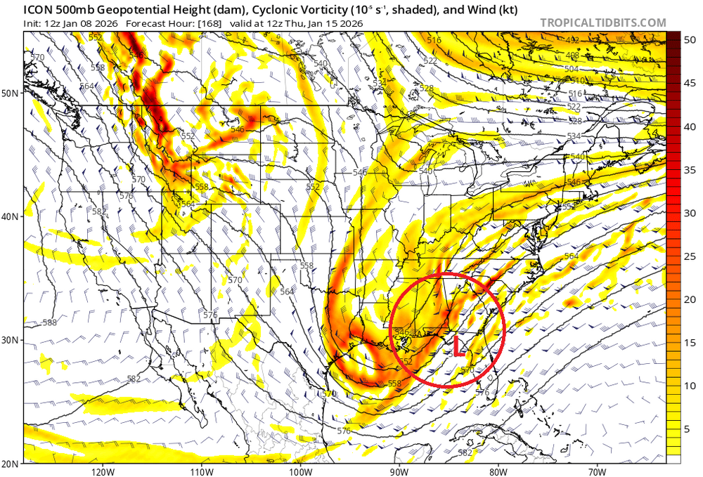
We need a surface low to develop in the southeast. With offshore baroclinicity and low pressure over the Lakes, it won't work (e.g., GFS, ECM, and even now CMC). In this scenario, it's too late except for maybe EMA and Maine. A phrase between a northern stream shortwave embedded in the longwave trof and the southern US ULL would probably initiate the surface low that we need. But so far, only the ICON is showing this. ICON Progression:
-
The GFS isn't particularly close. But the CMC did phase a little bit. On the 12z CMC so far, some aspects are better than 0z, some worse. I hate having both the GFS and ECM against us.
-
FWIW, the 0z CMC/GDPS did phase some of the southern stream like the 12z ICON. Not perfectly clean, but enough.
-
The ICON would be a nice snowstorm for most of our area if it played out that way. But the 12z ICON is significantly different than the 6z GFS and 0z ECM plus almost all individual ensemble members. By 0z Tue, the initial shortwave energy to eventually carve out the longwave trof in the MS valley is in WYOMING on the ICON. But it is noticeably further east through the DAKOTAS on the GFS and ECM. Related to this feature is the phasing of the upper level low in the Southwest US. The further west positioning of the northern stream shortwave on the ICON allows most of the southern stream energy to phase into the developing longwave trof, which sets the stage for a much better trof orientation and 500mb height field. I think the ICON is wrong with this feature, but I'll be watching subsequent runs closely.
-
The GFS and ECM ensembles continue to be strongly unsupportive of a snowstorm next week. It's a little surprising considering the forecasted high amplitude longwave trof in a favorable position. Right now there is way too much modeled vorticity in the Lakes region with one shortwave after another dropping through Michigan or southern Ontario keeping low surface pressure over the Great Lakes. The ECM is particularly hostile to a coastal snowstorm. The GFS at least looks marginally workable. It's yet another reminder how the specific evolution of the 500mb height field is critical for snowstorms and the long range 500mb anomaly charts are poor predictors for snow.
-
Just a minor comment - triglycerides are not a form of cholesterol. They are lipids used to store excess carbs as fat. It's true that they will decrease if you reduce processed carbs and sugar intake. But they also sometimes increase in people who are trying to eat more healthily - particularly in people who increase consumption of vegetables and grains to compensate for a reduction in meat.
-
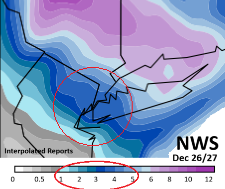
Nice job The 4 Seasons. Solid forecast and also great map of snowfall reports. Matches my hastily put together interpolation. NAM and eventually ECM did well. GFS, GEFS, RDPS, GEPS, and UK did not do well. The NYC area was in the bullseye for several days in the run-up... the NAM signaled over the last 36 hours that the jackpot area would end up northeast of the City, which proved correct. Ensembles were slow to respond and clung too tightly to the operational runs.
-
Snowy afternoon in the Taconics and Berks. +Sn reported at PSF. Looks like an easy 1-2" with more in the favored spots.
-
The subtropical jet has engaged periodically since early December, but mostly with a trof in the Southwest and typically leading to some kind of storm through the Lakes region. The Thurs-Fri event forecasted this week is a good example. I do agree about the likelihood of continued dry conditions.
-
Euro 264 hr
-
On today's models the cold returns after the 11th. But that's almost a week out. So things might not play out that way.
-
I do. That's why I mapped and posted the NWS reports. Just look at it. But if you just have to have a narrative summary for the event, I provided that too: A 1-5" event for the greater NYC metro with 6+ well north and east.
-
Pretty brutal to see zero forecast snowfall on the operational GFS, ECM, and GDPS out to 10 days in mid January with little to no help from the ensembles. There's really nothing even close to trackable right now. I hope and expect when the next event appears on the models it will do so unexpectedly.
-
This was not a "four to eight inch" snowstorm for the NYC area. The map of NWS snowfall reports visually describes the event quite well. Please stop perpetuating this fantasy. Facts matter.
-
Most of us were lucky last month to get a few minor snow events with cold temperatures and even a borderline moderate snowstorm despite the lack of any classic coastal low tracks. Now we are seeing some back luck with an unfavorable height field forecast out to the end of the mid-range during a peak snow climo period.