

Chicago Storm
-
Posts
18,169 -
Joined
-
Last visited
Content Type
Profiles
Blogs
Forums
American Weather
Media Demo
Store
Gallery
Posts posted by Chicago Storm
-
-
5 minutes ago, mimillman said:
You will bust low, I will bust high. But a 2-4” event from SLP tracking over the city is a win.
Trend has been for SLP to track SE of there now.
-
 1
1
-
-
12/26/09 is an event that comes to mind that had an extreme gradient through the Chicago metro.
I think you may be thinking of a direct one.
12/26/2009 was the surprise snowstorm. Cold temps and very high ratios were featured.
.-
1
-
-
5 minutes ago, Stevo6899 said:
Tbh this is how it feels for almost every storm. The models are good for highlighting the potential snow amounts, but where the bands setup always comes down to nowcasting.
In this case for NE IL/metro I mean more-so due to the R/S line and lake influence combination.
It's going to be really interesting to see how they both pan out.
-
 3
3
-
-
Models' Kuchera graphics are showing awful ratios, about 7 to 1 throughout the heavy band. DVN, on the other hand, is predicting ratios above 10 to 1.
Yea, can’t envision above 10:1+ ratios panning out for much of the duration of the storm. Can’t rule it out on the tail end though, as a bit of colder air tries to filter in.
It’s really interesting so see some of these offices go with amounts that either mirror or even exceed Kuchera based amounts on most guidance.
. -
This is gonna be one of those situations where you don't really have a full/total handle on how it's going to go until we're deep into it, for the metro/NE IL that is.
-
5
-
1
-
-
our resident wisconsin palm aficionado is tth now.
.-
 4
4
-
-
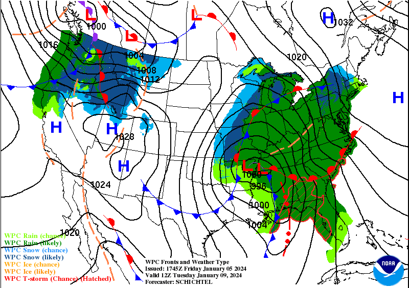
A lot of noise on guidance over the past 24 hours.
Most 0z guidance shifted a bit NW, and now most 12z guidance shifted bit SE.
-
3
-
-
10 minutes ago, weatherbo said:
I've noticed the official forecasts are almost always a blend of models.
They pretty much are forced into using the NBM.
-
1
-
2
-
-
.
-
9
-
 1
1
-
-
Two weekend waves have nearly doubled seasonal snowfall totals at ORD, from 3.9" to 7.4".
Friday night-Saturday morning wave snowfall totals...
ORD - 1.9"
MDW - 1.6"
RFD - 1.3"Saturday night wave snowfall totals...
ORD - 1.6"
MDW - 0.5"
RFD - 0.5" -
8 hours ago, michaelmantis said:So what is your level of interest? ;-)
Considering the 2 inches we got last night was the highlight of the season so far, anything more than that *has* to be exciting for all of us! :-)
I'd be not hoping/expecting much near the lake in NE IL but someone between Quad Cities and Collar Counties in IL may get a decent 6ish (+/- 2) event.
I’ve been at the point for years now that the only things that excite/interest me snowfall wise are big dogs (or at least medium dogs), record/near record occurrences, and abnormal/significant conditions. This one will be none of the aforementioned most likely, so overall interest is low.
However, looks like a solid 2-5”/4-7” kind of situation from SE to NW across the area, with lower amounts near the lake and downtown.
.-
4
-
-
On 1/3/2024 at 2:18 PM, Chicago Storm said:
I'll probably become more interested come Saturday, but until then it's a bit too early.
i guess we've reached that point...
-
2
-
3
-
-
0z Euro says I see you, and I raise you…
.-
2
-
 1
1
-
-
Forgot to mention it at the time, but while downtown for NYE/NYD I noticed some trees were budding.
-
1
-
1
-
-
That’s as exotic as it gets…

.-
8
-
-
lol 0z GFS late next week…
.-
1
-
1
-
-
The snow for tonight sort of came back from the dead, as it was shown a few days ago, before vanishing.
Looks like a 1-3" type of situation for tonight into Saturday morning across the area.-
7
-
-
1 hour ago, A-L-E-K said:
glad the euro put that 0z run behind it
It had a run similar to the 0z a day or so ago as well.
-
2
-
-
34 minutes ago, StormChaser4Life said:
I would love to know what model blend they're following. I do agree rain or mix will start before a changeover in the heavier rates in deformation band but I think they're too weak with low and a bit too warm.
i don't know why they still waste their time with these. they're always so bad.
-
4
-
1
-
-
this is our moment
zzzzz
.-
1
-
7
-
-
I'll probably become more interested come Saturday, but until then it's a bit too early.
There are a few players to watch that will factor into the evolution of this one, including what exactly happens with the lead weekend storm system.
-
4
-
2
-
1
-
-
December 2023 finished tied for the 4th warmest December on record in Chicago.
Top 10 Warmest December's
1. 43.4 - 1877
2. 40.7 - 1889
3. 39.7 - 1923
4. 39.0 - 2023
4. 39.0 - 2015
6. 38.4 - 1931
7. 38.0 - 2021
8. 37.8 - 1881
9. 37.7 - 1918
10. 37.4 - 1971 -
December 2023 finished tied for the 4th warmest December on record.
Top 10 Warmest December's
1. 43.4 - 1877
2. 40.7 - 1889
3. 39.7 - 1923
4. 39.0 - 2023
4. 39.0 - 2015
6. 38.4 - 1931
7. 38.0 - 2021
8. 37.8 - 1881
9. 37.7 - 1918
10. 37.4 - 1971-
1
-
-
Alek how about you start the thread when we get to that point
i’ll throw up a zzzzz to that.
.-
1
-
3
-
1
-
Jan 11-13th Blizzard
in Lakes/Ohio Valley
Posted
There hasn't been a NW trend with the current storm system in a while.