-
Posts
18,181 -
Joined
-
Last visited
Content Type
Profiles
Blogs
Forums
American Weather
Media Demo
Store
Gallery
Posts posted by Chicago Storm
-
-
Low at ORD this morning was 81. If this holds through midnight (actually, even if it stays at 79+), it will be the warmest min on record for so late in the season. Next closest is 78 on 8/27/2020.
We'll have to see if any storms or the lake-enhanced front brings the temp down before midnight.
It’s not gonna hold, no chance at this one.
. -
98/78/116 at ORD currently.
. -
ORD with a peak of 96° as of noon.
With clear skies, thermal ridge overhead, and compressional warming from the incoming front… 100°+ should be bank at this point.
.-
 2
2
-
-
ORD snuck in a 90 yesterday.
For today, it topped out at 98 at ORD, 98 at MDW, and 97 at RFD.
...2023 90°+ Day Tally...
17 - ORD
15 - MDW
11 - DPA
11 - ARR
11 - LOT
10 - RFD
9 - PWK
5 - UGN -
16 minutes ago, hardypalmguy said:
MKE hit 100. First 100 in August since 1988. I think it’s latest 100 ever as well.
Port Washington CMAN site reporting 100.
About as close as you're gonna get to an official 100 for you there.
-
 2
2
-
-
Currently 98/78/116 at ORD.
One of the high end combinations on record.
-
Will end up breaking the record high max and record high min temps today at ORD.
-
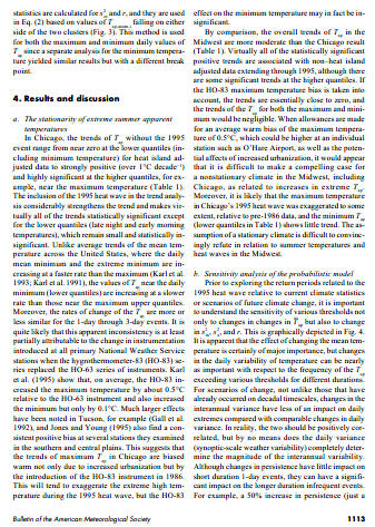
Wow, historic. This may very well be the highest RELIABLE heat index reading on record. As noted by Tom Karl & Richard Knight, in their 1996 paper examining the role of climate change on the 1995 heat wave, the HO-83 hygrothermometer had a warm bias of at least 0.5C. This was one of the reasons they were unable to confirm any impact from climate change on the occurrence of extreme heat episodes. However, other research has found warm biases of as much as 2-3C on sunny, light wind days. The design allowed warmed air to recirculate into the housing for the sensor. I hate to bring this up since I was accused of trolling the 1988 drought thread, but ironically it was noted climate denier, Steve McIntyre, who first brought this to my attention.

enough already with this nonsense.
.-
 2
2
-
-
-
80° dew point at ORD currently.
Highest and first 80°+ since 1999.
.-
 4
4
-
-
Wednesday is now looking like it'll likely be the hottest day of this period around here, and the hottest day of the year.
Back-door front timing for Thursday has been speeding up on most guidance, otherwise there would have had a higher temperature ceiling for then.
And the trend since reversed. Tomorrow has the best shot at 100+ we’ve seen in years.
.-
 2
2
-
-
Wednesday is now looking like it'll likely be the hottest day of this period around here, and the hottest day of the year.
Back-door front timing for Thursday has been speeding up on most guidance, otherwise there would have had a higher temperature ceiling for then.
-
Topped out at 91 at ORD, 91 at MDW, and 91 RFD yesterday. Cooler today in the wake of a back-door front.
...2023 90°+ Day Tally...
15 - ORD
14 - MDW
10 - DPA
10 - ARR
10 - LOT
9 - RFD
8 - PWK
4 - UGN -
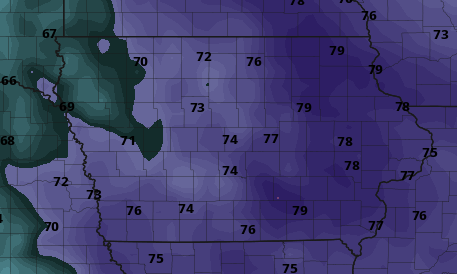
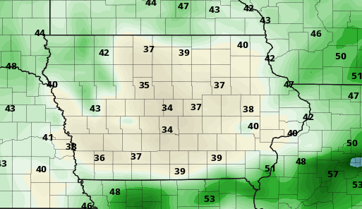
Bit of a disagreement on the Td's in Iowa between guidance. GFS shows unbelievably comfortable Td's for mid-August, while the Euro brings in the jungle at the same time.
0z Euro (valid at 18z Monday)
6z GFS (valid at 21z Monday)
that’s because the GFS mixes an unrealistic amount.
. -
LER across portions of SE Wisconsin and NE Illinois tonight.
Not a perfect setup by any means, but there's a solid fetch and nice convergence zone just inland.
.-
 1
1
-
-
Outlier right now. Signal is still there, just shifted more toward plains with backdoorland for us.
that’s the seasonal trend, so lock it in.
.-
 2
2
-
-
stop wasting time looking at GFS temp plots.
. -
Usually I'm not big on the long range thoughts as much during the summer, mostly cause I'm out actually enjoying things. However...
I did want to mention that it is likely that this active seasonable/trough/NW flow type pattern will stay locked in around the Midwest/Great Lakes for the next week or so. This is partially the product of a generally -NAO/+PNA regime in place on the larger scale.
Looks like the next push of hotter temps/higher humidity will be centered around the Aug 19-24th period or so, as the -NAO relaxes and the PNA flips fairly negative.
-
 3
3
-
-
In terms of this sub-forum, I'd actually be more interested in the severe threat with the MCV across portions of IL/IN on Saturday...more-so that the severe threat with the main storm system on Sunday across the Western portion of the sub-forum.
Likely we'll see a solid corridor with flood potential across portions of MO/IL/IN, tonight through Saturday as well.
-
 1
1
-
 1
1
-
-
On 8/1/2023 at 7:09 PM, frostfern said:
El Nino pretty much guarantees a boring winter though.
but it doesn't.
-
 1
1
-
 1
1
-
-
Snuck in a 90 at ORD and MDW today.
...2023 90°+ Day Tally...
14 - ORD
13 - MDW
9 - DPA
9 - ARR
9 - LOT
8 - RFD
8 - PWK
4 - UGN -
July 2023 finished as the 7th wettest July on record for Chicago.
Top 10 Wettest July's:
1. 11.15" - 2011
2. 9.56" - 1989
3. 8.98" - 1957
4. 8.84" - 2010
5. 8.33" - 1982
6. 7.68" - 2017
7. 7.61" - 2023
8. 7.58" - 1969
9. 7.31" - 1963
10. 7.18" - 1875 -
July 2023 finished as the 7th wettest July on record for Chicago.
Top 10 Wettest July's:
1. 11.15" - 2011
2. 9.56" - 1989
3. 8.98" - 1957
4. 8.84" - 2010
5. 8.33" - 1982
6. 7.68" - 2017
7. 7.61" - 2023
8. 7.58" - 1969
9. 7.31" - 1963
10. 7.18" - 1875 -
Topped out at 93 at ORD, 93 at MDW, and 92 at RFD today.
...2023 90°+ Day Tally...
13 - ORD
12 - MDW
9 - DPA
9 - ARR
9 - LOT
8 - RFD
8 - PWK
4 - UGN


August 2023 General Discussion
in Lakes/Ohio Valley
Posted
ORD is now 99/79/118.
The heat index of 118° ties the highest on record, set on 7/13/1995.