

Chicago Storm
-
Posts
18,192 -
Joined
-
Last visited
Content Type
Profiles
Blogs
Forums
American Weather
Media Demo
Store
Gallery
Posts posted by Chicago Storm
-
-
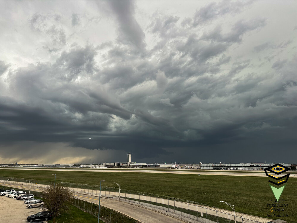
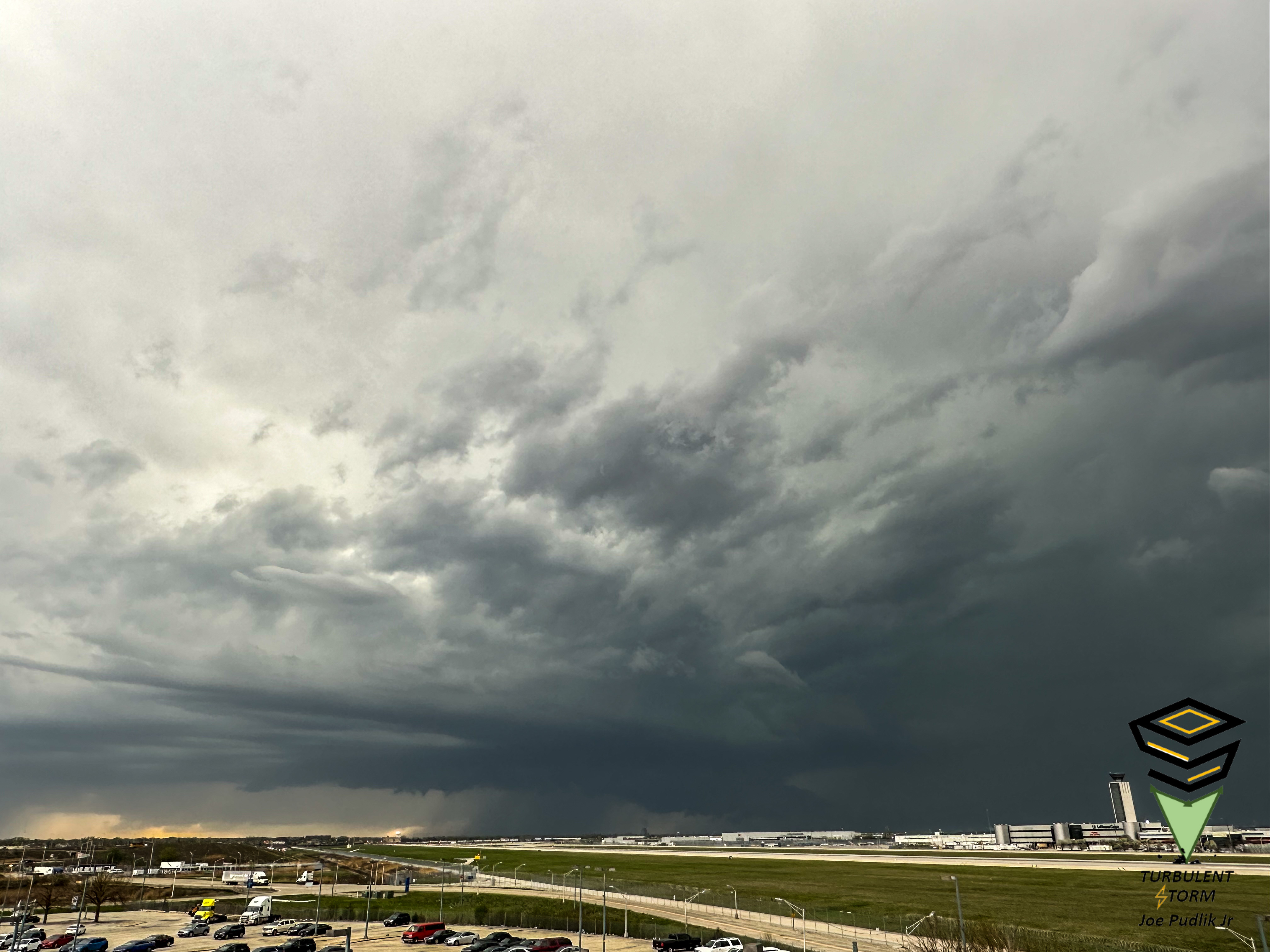
Had a view of a wall cloud here at ORD between 5:40-6:10PM, associated with a severe t'storm warned supercell structure that tracked across Kane and Northern Cook Counties.

-
 11
11
-
-
some of ya'll need a touch with reality. outside of 2018, april tends to be what april should be.
...April 60+/70+/80+ Days & Monthly Average By Year For Chicago...
April 2023 (Thru 4/19)
60+: 13
70+: 7
80+: 4
Month Average: +6.8April 2022
60+: 9
70+: 3
80+: 1
Month Average: -2.7April 2021
60+: 15
70+: 8
80+: 3
Month Average: +2.2April 2020
60+: 14
70+: 4
80+: 1
Month Average: -1.3April 2019
60+: 14
70+: 5
80+: 1
Month Average: 0.0April 2018
60+: 8
70+: 1
80+: 1
Month Average: -8.5April 2017
60+: 19
70+: 11
80+: 1
Month Average: +4.0April 2016
60+: 12
70+: 8
80+: 2
Month Average: -1.9April 2015
60+: 16
70+: 3
80+: 0
Month Average: -0.3April 2014
60+: 14
70+: 5
80+: 1
Month Average: -1.1April 2013
60+: 11
70+: 3
80+: 1
Month Average: -2.8April 2012
60+: 16
70+: 3
80+: 0
Month Average: +1.0-
 4
4
-
-
On 4/18/2023 at 6:53 AM, bowtie` said:Looks like KORD will be warmer than KIND this morning. The Lake is your friend.
The difference actually isn’t the lake in this case, with a 5-10MPH westerly wind at ORD.
I’d guess it’s more of a case where IND being on the edge of the metro/rural land, with a W-erly wind/less UHI, is making the difference.
.-
1
-
-
56 minutes ago, Harry said:
Been a while since I have seen the NAO and AO tank like the models are showing.
We saw a similar period during the 1st half of March.
During that period we saw a mix of mild (AA) and cool (BA) temps, with an average to above average active pattern.
So all in all, this could be similar, just a solid month+ later in the year.
-
1
-
-
On 4/15/2023 at 5:15 PM, Harry said:
So I am seeing mjo crawl through phase 7 on its way to phase 1 and going into the cod. NAO, AO, EPO all tanking while the PNA goes positive?

The EPO isn't going negative in any significant or consistent way, and the PNA won't be going positive in any significant or consistent fashion either.
As you mentioned though, we will be seeing a -NAO/-AO pattern for this 2nd half of April. Pair that with a EPO/PNA that are going to be in flux throughout, and an MJO steadily sliding through phases 7-8-1-2.
This will lead to more a classic spring/April rollercoaster pattern for this 2nd half of April, and into the start of May as well. Bouts of mild and cool temperatures are to be expected, with an average to above average pattern in terms of activity.
-
1
-
-
On 4/4/2023 at 9:55 PM, Chicago Storm said:
I feel highly confident in saying Chicago has seen it's last accumulating snow for the season, which was back on 3/13. There's a better chance of racking up numerous 70+ days this month than seeing more accumulating snowfall.
or not.
still will end up with more 70+ days (and 80+ days) than tenths of an inch of total snow, so there's that.
-
On 4/7/2023 at 3:39 PM, Chicago Storm said:
And we're back with some new ones to watch...
Earliest Last Measurable Snowfall Of A Season:
1. 1994 - 2/28
2. 1985 - 3/3
3. 2012 - 3/4
4. 1945 - 3/6
5. 1953 - 3/8
6. 1946 - 3/9
6. 1919 - 3/9
8. 1999 - 3/10
9. 1963 - 3/12
10. 2023 - 3/13Least Seasonal Total Snowfall:
1. 9.8" - 1920/21
2. 11.5" - 1921/22
3. 12.0" - 1936/37
4. 14.3" - 1948/49
5. 18.0" - 1898/99
6. 18.2" - 1901/02
7. 18.9" - 1924/25
8. 19.0" - 1914/15
8. 19.0" - 1912/13
10. 19.7" - 2022/23
(11. 19.8" - 2011/12)cancel that.
jinxed those.
-
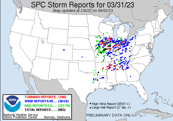
The tornado count from the March 31st outbreak in Illinois now stands at 37, making it the 2nd largest tornado outbreak on record for Illinois. DVN is still combing through things, so that number could still change.
March 31st, 2023:
LOT: 17
DVN: 6
ILX: 12
LSX: 2EF-U: 4
EF-0: 9
EF-1: 16
EF-2: 7
EF-3: 1Biggest Illinois Tornado Outbreaks:
1. 39 - 4/19/1996
2. 37 - 3/31/2023
3. 35 - 4/2/2006
4. 29 - 12/1/2018
5. 25 - 11/17/2013-
2
-
-
42 minutes ago, Chambana said:
impressive stretch of heat for the sub. This looming El Niño has piqued my interest. Has there ever been a triple dip La Niña into Strong El Niño?The only other two 'triple dip' La Niña occurrences (1974-76 & 1999-2001) were followed by neutral ENSO summer conditions. So this will be new and unknown territory we are entering.
-
As posted in the Chicago records thread...
ORD had a high temperature of 83° today, which broke the record high temperature for the date of 82°, which was set in 1887 and 1941.
-
2
-
-
ORD had a high temperature of 83° today, which broke the record high temperature for the date of 82°, which was set in 1887 and 1941.
-
2
-
-
It's not often that you see a full week with temps in the 70's and 80's in mid-April, without any sort of lake breeze...Whether it be in April, May or June.
Managed to do it earlier this week with light winds, but good gradient alignment. Now as we have transitioned into mid week, and continuing into late week, stronger winds are preventing development.
-
1
-
-
4 minutes ago, rainsucks said:
Lmao, of course ORD gets 79’d while both PWK and MDW hit 80+
MDW hit 80 for about 2 minutes.
-
Final event (April 4th & 5th) tornado count of 9 in IL.
-
1
-
-
It’s currently 93° in Pierre, SD and 50° in Aberdeen, SD…With a difference of 150 miles between both locations.
That’s probably one of the sharper non-frontal boundary gradients you’ll ever see.
Check out the significant inversion on the HRRR simulated sounding, from along the SD/ND border this afternoon.
-
1
-
-
And we're back with some new ones to watch...
Earliest Last Measurable Snowfall Of A Season:
1. 1994 - 2/28
2. 1985 - 3/3
3. 2012 - 3/4
4. 1945 - 3/6
5. 1953 - 3/8
6. 1946 - 3/9
6. 1919 - 3/9
8. 1999 - 3/10
9. 1963 - 3/12
10. 2023 - 3/13Least Seasonal Total Snowfall:
1. 9.8" - 1920/21
2. 11.5" - 1921/22
3. 12.0" - 1936/37
4. 14.3" - 1948/49
5. 18.0" - 1898/99
6. 18.2" - 1901/02
7. 18.9" - 1924/25
8. 19.0" - 1914/15
8. 19.0" - 1912/13
10. 19.7" - 2022/23
(11. 19.8" - 2011/12)-
 1
1
-
-
On 4/5/2023 at 2:41 PM, Malacka11 said:
Here are two videos from yesterday. First one is of the supercell itself and the second is from inside the tornado. I'd like to apologize in advance for not only using phones, but also recording in vertical format. Didn't have time to pull the DSLR out unfortunately for good shots of the storm, and obviously I'm just happy to have any footage from inside the tornado at all.
Oh yeah, and please excuse my language in the second video. Hard to stay PG when you think you're about to get maimed. Looking back I didn't even duck down, idk what I was thinking.
https://youtube.com/shorts/d5M407cuge4?
feature=sharehttps://youtube.com/shorts/fRWcBVP-nUA?feature=share
Again, apologies for the excessively amateur impression I'm making here.
welcome to the 0 meter club.
-
2
-
-
8 hours ago, rainsucks said:
@Chicago Storm your thoughts on the warmth potential next week? I have to admit, it does look like things could heat up big time, but I’m also concerned that the warmth could eventually be shunted to our south due to the flattening of the ridge.
Haven't had a chance to put out any April thoughts with the active severe weather pattern ongoing, but...
Spring is here for April, let's just put it that way. We are losing a lot of the ridging that has been in place up north, which was shunting the remaining cold air down into our region.
I feel highly confident in saying Chicago has seen it's last accumulating snow for the season, which was back on 3/13. There's a better chance of racking up numerous 70+ days this month than seeing more accumulating snowfall.
-
4
-
2
-
-
Forgot to mention...
This past Friday (3/31) was not only the first 60+ day of the year at ORD, but it was also the first 70+ day as well.
-
1
-
-
I'll be unable to chase this afternoon/evening due to work, as I had a decision between chasing today or Friday, and chose Friday.
If I were able to, I would most definitely head out towards the IL/IA border, in anticipation of the afternoon/evening round of potential development in the vicinity of the warm front.
Might still attempt to make a play on this morning/midday round if it moves in quick enough, and looks to be producing quality damaging winds/hail still.
-
2
-
-
1 minute ago, largetornado said:
After looking at 18z, HRRR would have me chasing wednesday. If i went off the nam suite, i would not chase at all but its apparently been having problems this year. At this point, any storms that can become surface based will have a top tier environment to work with. I wish the SPC had a outlook that conveyed spatial coverage as well as potential intensity. Tomorrow would be a slight risk for storm coverage and a moderate risk for intensity IMO.
They do. Risk level is coverage based and hatching is for significance.
Their system is still quite flawed, though.
-
2 hours ago, Chinook said:
Does this qualify as a derecho?
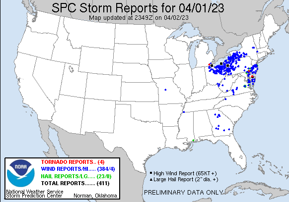 2 hours ago, WxSynopsisDavid said:
Factor in the stuff from 3/31 and yes. But concerning 4/1, there's a gap in central PA where there were no wind reports.
3/31 and 4/1 were two separate events, and wouldn't really consider either day to have had a derecho.
3/31 featured mixed mode, which produced corridors of damaging winds. 4/1 had two separate complexes, neither of which had the distance/longevity.
-
2
-
-
You said Galesburg right?
For now.
Could readjust as I get closer.
.-
1
-
-
About to hit the road in Naperville. Late to the game. Somebody who knows what they're doing, tell me where to go.
I’m about 30 minutes ahead of you.
.-
1
-

April 2023 General Discussion
in Lakes/Ohio Valley
Posted
A mixed convective rain/snow/graupel shower fest today, and possibly tomorrow as well.
.