

Chicago Storm
-
Posts
18,652 -
Joined
-
Last visited
Content Type
Profiles
Blogs
Forums
American Weather
Media Demo
Store
Gallery
Posts posted by Chicago Storm
-
-
I've been busy with other things, so haven't been able to focus on or put out any thoughts on the long range as of yet. Hopefully I'll have something out in the next day...
But, for now...
-I've seen some on social media trying to compare this upcoming period to what we saw in early-mid January. However, the setup on the large scale has differences when factoring everything in, so the outcome shouldn't be expected to be the same.
-Significant stratospheric warming is on the horizon. The Euro suggests this period of warming could be a full on SSWE, and could be the one that leads to the demise of the SPV for the season.
-The MJO appears as though it does not want to play ball, looking to stay in warmer phases and the COD during this period.
-This last two points regarding the SSW and MJO likely means it'll be more of a battle this go around.
-Based on the positioning of everything, temps will likely be more of a rollercoaster mix of below/seasonal/above.
-The pattern is likely to be active across the CONUS, with a W/NW flow. We'll see a constant parade of disturbances/troughs break off Bering Sea/Aleutian/Pacific mean troughing, then skimming across the CONUS.-
 5
5
-
 3
3
-
-
About as great of a start to February as you can get.
55° at ORD currently, 1° off the record high for today.-
1
-
-
I thought being a lions fan was tough, guess I hadn't seen nothing yet. Then they choke for the world to see. Almost everyone in America was rooting for them, except for a few divisional fans. This one's gonna hurt for awhile.
don’t worry, i’m a falcons fan.
it could be worse…-
 6
6
-
 1
1
-
-
Best weather day of the month today.
-
1
-
1
-
-
detroit peeps, you alive and alright?
-
3
-
2
-
-
i've been waiting for a quality beavis meltdown this winter.
took a week of fog, rain, and rapid snow melt in the wake of our usual two weeks of winter to make it happen, but here we are.
-
6
-
-
Ended up being fairly uneventful around here.
The ground (Roads/sidewalks/etc) glazed up, due to the residual effects of the recent cold. However, ice didn't accumulate on any other surface, due to marginal temperatures and dew points.
-
Will be interesting to see how the mixed p-types work out for this one.
These events on the heels of a solid period of cold usually have some surprises. We'll see if this one does...
-
alek has turned into beavis-lite.
hate to see it.
-
4
-
-
5 minutes ago, A-L-E-K said:
i work by ord, same turd winter as lakeside
bad take.
ORD finished slightly above normal in snowfall for Oct and Nov, and will now do the same for Jan.
obviously it has been a torch temp wise until the past week or so, but snowfall wise it is as expected.
-
3
-
-
29 minutes ago, A-L-E-K said:
not our year lol
ORD and RFD are above average for snowfall on the season through today.
suck 2 b lakeside.
-
2
-
1
-
-
We’re getting some unofficial reports in our newsroom of 2 feet of snow in Michigan City. 19” in New Buffalo.
I almost went out that way to “chase” the LES. Guess I should have.-
1
-
-
Final event snowfall totals…
ORD - 1.6”
MDW - 1.6”
RFD - 1.5” -
8 minutes ago, Chambana said:
Strong El Niño gonna strong El Niño
has nothing to do with the pixie dust fest, if that's what you're trying to insinuate.
-
A disturbance and FGEN brought a bit of snow to the area last night...
ORD 0.3"
MDW 0.4"
RFD 0.4"-
1
-
-
really dawg... little desperate now.
-
4
-
4
-
-
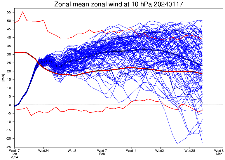
It was a long road, but we finally have an official SSWE on our hands...
The first period of significant warming in late December and early January, which missed SSWE "criteria", was a significant driving force in the recent/current wintry pattern. This secondary period of significant warming and actual SSWE could lead to a period of interest as we hit the very end of January and head into February.
-
4
-
1
-
-
1 minute ago, A-L-E-K said:
trends have been drier today
sad
Quite the opposite, actually.
GFS, Euro and GEM (Excluding the LE) are all the wettest they have been for Thur/Fri.
-
2
-
-
Given it’s originating from up around Seattle (Pac NW/BC), it’s more of a hybrid type of deal and not a clipper.
Might want to puts some dates in the title too.-
2
-
1
-
-
It's cold, but nothing really record breaking.
So fairly zzzzz overall.
-
2
-
 1
1
-
-
Dusted Saturday evening/night around here, with a few tenths of snowfall accumulation.
0.2” at ORD, T at MDW, and 0.5” at RFD. -
Just heard one of those frost quakes/cryoseisms a bit ago.
.-
3
-
-
7 hours ago, A-L-E-K said:
Pattern change was a bust
Zzzzzz
sucks 2 b u.
-
1
-
-
3 hours ago, ChiTownSnow said:
Models kicking out a few tenths of an inch (0.01 to 0.1) of precip over N IL tonight. I assume would be very high ratios.
3 hours ago, Baum said:VERY HIGH SNOW:LIQUID RATIOS, LIKELY IN THE 20-30:1
RANGE. -LOT AFDShould be able to kick out 0.5" to 2" area wide.
2024 Short/Medium Range Severe Weather Discussion
in Lakes/Ohio Valley
Posted
As is always the case, this thread is for short term activity that isn't thread worthy and medium range potential.