

ldub23
-
Posts
1,933 -
Joined
-
Last visited
Content Type
Profiles
Blogs
Forums
American Weather
Media Demo
Store
Gallery
Posts posted by ldub23
-
-
On 9/25/2023 at 1:50 PM, WEATHER53 said:
Temps: -1
Snowfall:14-18” for DCA, IAD, BWI
Have two months at a 75% probability of being -2 and one month with a 66% probability of being +1. Will follow Nino pattern and go with Jan and Feb as -2
Primary analog years:1953-54 and 1985-86
Secondary analog years with first two having more weight: 1986-87 and 2010-11. Also 1954-55, 1980-81, 1983-84, 1991-92, 2019-20.
Couple of lousy years, some solid cold ones, major storms not showing up. Might battle suppression this year. At least way better than last few.
Im thinking a little bit higher, 18-22 inches
-
17 minutes ago, ldub23 said:
We have had a pattern of lows forming off the SE coast and moving offshore. If this pattern repeats in dec-feb it will be quite snowy especially I-95east


Its been very persistent
-
We have had a pattern of lows forming off the SE coast and moving offshore. If this pattern repeats in dec-feb it will be quite snowy especially I-95east
-
26 minutes ago, Terpeast said:
4 degrees CELSIUS colder than climo over a 3 month average imby?
No way that's gonna happen. (and I'm one of those who is cautiously optimistic about 23-24)
It was lower that that in 76/77 and 77/78
-
 1
1
-
-
-
8 hours ago, WxWatcher007 said:
I don’t think the Niño will stick around enough to disrupt next year. I don’t like going super long range, but next year looks…not good…
It’s just one of those exceptionally active periods in the basin. It took a third year Nina to slow down last year and that was a low grade speed bump.
JB has said next season will double this years numbers with an ace well over 200
-
30 minutes ago, Windspeed said:
12z GFS op missing the Leewards, however, there was a notable swing in the CONUS setup in 240-260 range vs previous runs. ULL over Florida and with increased heights over New England. The hurricane would potentially get driven near the Mid-Atlantic region. Might get interesting on this run... But, of course, this is late in the medium range. Main takeaway here is the WAR rebuilds into CONUS where previous runs it does not. See if this turns into a trend with this evening's runs.

It does take a NW turn
-
-
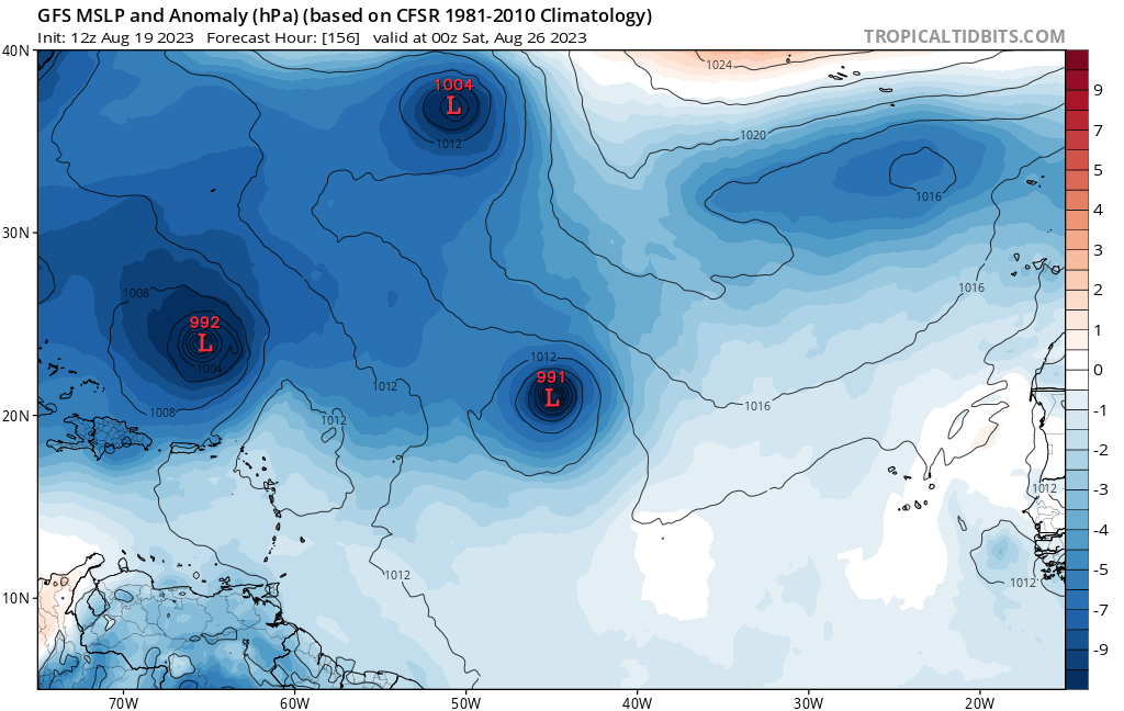
Euro further west with Idalia part 2

-
 2
2
-
3
-
-
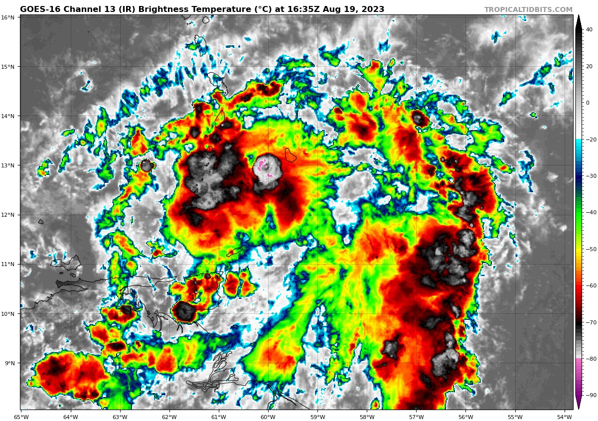
The center of frank appears to be about to zip out of the convection.
-
1 hour ago, lee59 said:
Franklin is the only one that looks worthy enough to have a name.
Gert and emily should never have been named. Just getting numbers up. Euro has come way down on Frankie. I dont know about 1893 but comparing this garbage to 1995 is beyond a joke

-
41 minutes ago, WxWatcher007 said:
Yeah, it looks like it's close if not already a TC. We'll see what recon finds later.
JB is not giving up. He doesnt mention hazel but it formed in the same place
-
1 hour ago, tiger_deF said:
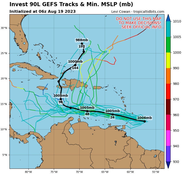
Figured I'd make a thread for this disturbance. 90L has come on the scene rather quickly - As a disturbance from the western edge of the monsoon trough, models only started picking up on potential development of this system a few days ago. 90L has appeared to be steadily organizing over the past day, with popcorning CBs and early indications of banding patterns. Model-wise, a powerful trough is expected to pick up the developing system through Hispaniola and potentially posing a threat to Bermuda down the line. However, as indicated by the GEFS spaghetti plot, there are lots of options still on the table, and a great deal of uncertainty as to the future track.

Keep us updated. Good work.
-
 1
1
-
-
50 minutes ago, olafminesaw said:
Lots of fish activity

But less fishy than 06Z
-
JB has spoken. This will be the upcoming winter.
-
 2
2
-
-
T
13 minutes ago, GaWx said:The GFS came alive

-
16 minutes ago, GaWx said:
GFS 12 runs out of 63 since 7/31 with hurricane (7 of them over last 11 runs)(last 9 H within 8/25-30):
-7/31 12Z: hit SC 8/16
-8/3 6Z: GOM hit MX/TX border 8/16
-8/6 0Z: MDR 8/18-21
-8/9 18Z: just off SC 8/25
-8/11 0Z: GOM just off LA 8/26
-8/13 0Z: GOM 8/26-8
-8/13 6Z: GOM 8/25-6 that hits MS 8/26-7.
-8/13 18Z: GOM 8/25 hits S TX 8/26
-8/14 0Z : off SC/NC 8/26-29
-8/14 6Z: off NC 8/28-30
-8/14 12Z: GOM 8/27 hits LA 8/28
-8/15 6Z: GOM 8/26 hits FL Panhandle 8/27All i see is a weak broad low in the west GOM. No hurricane anywhere thru aug 31.

-
12 minutes ago, nwohweather said:
As long as you have all that saharan dust out there, I don't care what any model shows
GFS has a cane in the GOM but it seems highly unlikely that will happen. At 216 is where it begins but what actually will happen is it develops in the east pac. The pattern hasnt changed 1 iota because there is nothing behind it developing. 0/0 Aug thru aug 30 on the GFS now except for an unlikely GOM cane. I think the GFS is confusing the Colombian heat low that is hostile for development for an actual disturbance. Another argument against development is that huge front blasting off the east coast. As i often say if you want to see west carib/gom development you want a locked and loaded high dominating the west ATL. Since its peak and something should be happening i give it a 1% chance. Only a 99% chance it doesnt develop

-
Just now, ldub23 said:
First hint the GFS might be starting the season

For the first time it shows something developing behind the cane hitting TX which could indicate a pattern change

But then it shows a second low forming in the west gom
read fast
-
1 hour ago, GaWx said:
On the 12Z EPS through 240, I counted 15 Hs (30% of members) at a minimum from just the wave now in the E MDR. There's something like 30 members from all of the waves, combined, with a H. There still are four different possibilities to watch during the next ten days.
First hint the GFS might be starting the season
For the first time it shows something developing behind the cane hitting TX which could indicate a pattern change
But then it shows a second low forming in the west gom
-
8 hours ago, GaWx said:
The 0Z GFS has a H in the GOM 8/26-8 moving slowly W. That makes 6 GFS runs out of 53 (11%) since 7/31 with a H on the run:
-7/31 12Z: hit SC 8/16
-8/3 6Z: hit MX/TX border 8/16
-8/6 0Z: MDR 8/18-21
-8/9 18Z: just off SC 8/25
-8/11 0Z: just off LA 8/26
-8/13 0Z: GOM 8/26-8The last three on this list are all from the AEW now in the E Atlantic, the same one the EPS has been harping on since August 4th.
You didnt mention it was on its way to cat5. Im skeptical though because there is nothing behind it which says the pattern hasnt changed.

It will be really hard to get a hurricane in the GOM anytime soon with the East pac on fire like this.

-
The Man says it again. This will be a Sept to remember. 1954? 85?
https://www.cfact.org/2023/08/11/hurricane-update/
- "This hurricane season, a September to remember is on the table.
- The expected impacts on the U.S. Coast have increased compared to the last forecast.
-
Keep in mind that this is, in essence, a “normal” season.
- 1985 and 1954 were “normal” seasons but had a high impact, and this may be like that."
And just wait till next season. Double the numbers, triple the fun
Note that next year may be a doozy of a season. I believe this is a bounce-back El Niño in response to the longest and strongest MEI El Niño on record, so we should collapse it and go back to a La Niña base state. SSTs will remain warm, and so that may be a season number-wise (at least for totals) two times higher than this year.
-
1
-
3 hours ago, GaWx said:
1. Indeed, the 0Z GFS has a H south of LA on 8/26. That makes 5 GFS runs out of 45 (1 in 9) since 7/31 with a H on the run:
-7/31 12Z: hit SC 8/16
-8/3 6Z: hit MX/TX border 8/16
-8/6 0Z: MDR 8/18-21
-8/9 18Z: just off SC 8/25
-8/11 0Z: just off LA 8/262. At 240, the 0Z EPS is once again quite active with that lead wave.06 gfs has nothing except a weak low thats going to recurve. Im amazed NOAA was so high and no one is reducing numbers by alot.
-
37 minutes ago, GaWx said:
The new 0Z Euro has the active EPS system as a strengthening 1005 mb low just S of PR moving WNW at 240 and has very little for the followup wave that recurved on the 12Z.
GFS has this but im doubtful because if things are more favorable then there would be something behind it and there isnt

and JB is saying it again
This is the euro you mentioned. 5 more days and it might be where the gfs has the cane

Winter 2023-2024
in Weather Forecasting and Discussion
Posted