

ldub23
-
Posts
2,281 -
Joined
-
Last visited
Content Type
Profiles
Blogs
Forums
American Weather
Media Demo
Store
Gallery
Posts posted by ldub23
-
-
-
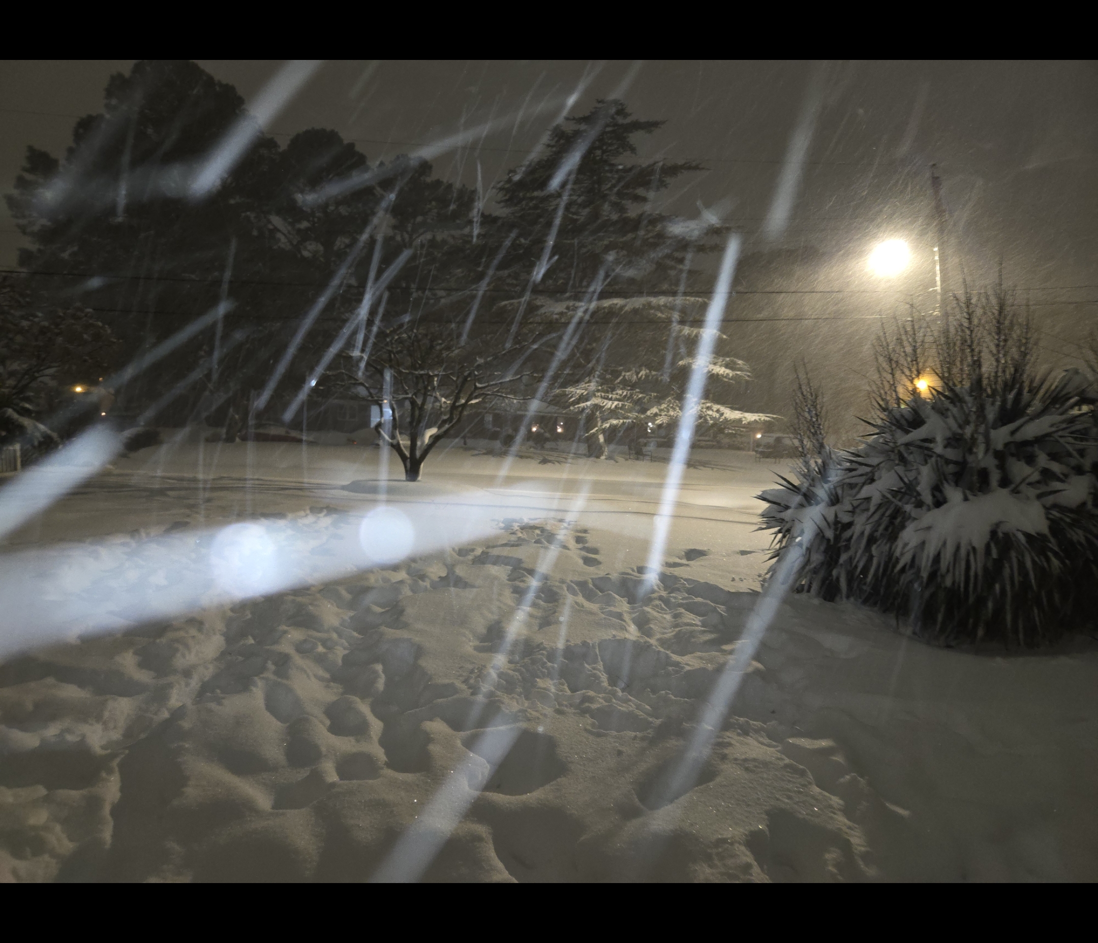
1 nine inch storm and a total of 13 inches. Some cold temps. B+
-
-
-
11 hours ago, Conway7305 said:
I’m ready for warmth and hurricane season. Bring it on. LR models have loads of warmth. Next winter will be fun to track again. This winter we did much better than the last few so I am happy.
-
 1
1
-
-
1 hour ago, VARTV said:
snow pack STILL showing up on visible sat for NE NC and far southern VB!
Nice. Its gone here except for piles in parking lots
-
-
1 hour ago, JB Fins said:
Trying to muster sympathy...yeah, I got nuthin' for ya.

At least i have saved a big snowball for posterity.
-
3
-
-
22 minutes ago, EverythingisEverything said:
It just seems like, it happened so fast. I was trying to absorb the moment and then poof gone! lol. The snow is melting fast too!
Hard to believe it was just WEDS it was storming.
-
13 hours ago, EverythingisEverything said:
Great that we are all above climo. Does anyone have post storm depression?
-
1
-
-
1 hour ago, Stormpc said:
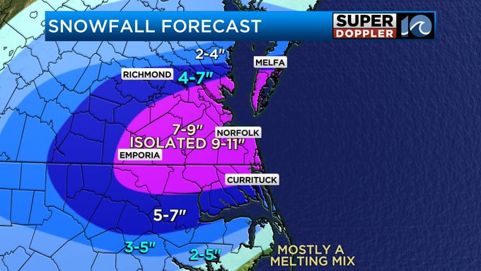
CURRITUCK COUNTY 2 NNW CURRITUCK 14.0 IN 0120 PM 02/20 EMERGENCY MNGR
KNOTTS ISLAND 13.0 IN 0120 PM 02/20 EMERGENCY MNGR
SLIGO 12.0 IN 0120 PM 02/20 EMERGENCY MNGR
MAPLE 12.0 IN 0120 PM 02/20 EMERGENCY MNGR
3 NNE SLIGO 12.0 IN 0120 PM 02/20 EMERGENCY MNGR
2 WNW MOYOCK 12.0 IN 0120 PM 02/20 EMERGENCY MNGR
COROLLA 11.0 IN 0120 PM 02/20 EMERGENCY MNGR AYDLETT
If you hadnt got that sleet you may have hit 15. As i type getting a last dying flurry
-
1
-
-
3 minutes ago, RIC Airport said:
Congrats to all! This was a very fun event! Tracking snow is exhausting. I crashed last night without the stress.
It was a win for all. Sun doing a number on the roads.
-
 1
1
-
-
9 minutes ago, PortsmouthWeather said:
Just measured 10 inches,still pouring down. Thinking we will end up with 12-13 inches
About 9 here. Nice to see all of us score
-
2
-
-
About 5.5 here. Im old. Chest about explode after brooming a path to car and clearing it
-
5 or 6 still possible here.
-
-
-
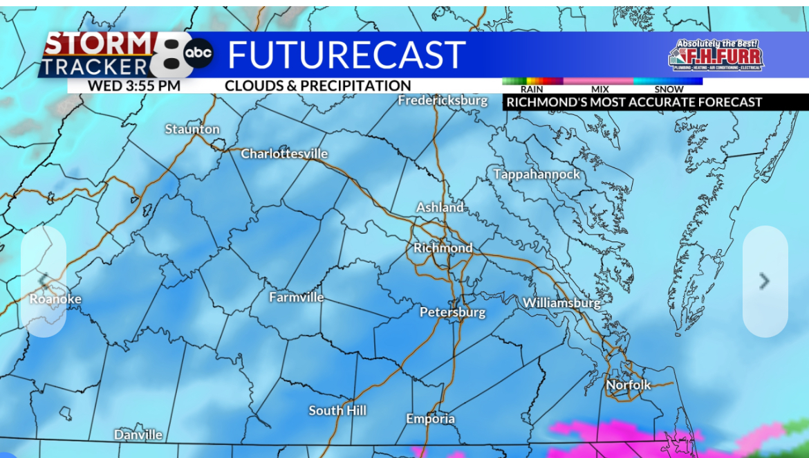
US Highway 17 between Jacksonville and Bew Bern in North Carolina treated ahead of the anticipated winter storm tomorrow and tomorrow night. I am making my way to Southeast Virginia for all day coverage tomorrow.
-
Ric will be in a warning. Advisory north and west. If Currituck stays mostly snow they will cash in. Will be interesting to see if that second round of light snow develops late am thursday
-
WVEC GRAF model has 4.9 for RIC 9.7 for NN 12.1 ORF 10.6 Elizabeth CITY
-
1
-
-
23 minutes ago, RVAman said:
John Bernier knows this area better than anyone. I trust him at this point. Now if the 18z EURO jumps off the coast all of these numbers will decrease dramatically by tomorrow.

Future cast here isnt showing a mix. Wavy has 6-10 for NE NC. Also has some lt snow redeveloping late thurs am/aft as the upper low goes by
Same as 7am
-
7 minutes ago, Stormpc said:
Fronto banding on the northwest side through Richmond and west.
The American models hate Northeast North Carolina. Maybe right
Local future radar has all snow for NE NC
-
Our Currituck friend might be the big winner again
-
5 minutes ago, EverythingisEverything said:
Oh my word! Va Beach is not ready. What is the timeframe? My brother is leaving for Mrtyle Beach on Wednesday?
WednesdaySnow, mainly after 10am. High near 32. Chance of precipitation is 90%.Wednesday NightSnow. Low around 26. Chance of precipitation is 90%.ThursdayA chance of snow before 1pm. Partly sunny, with a high near 34. Breezy. Chance of precipitation is 30%.-
2
-
2025 hurricane season forecast contest -- entries will be accepted to Tuesday June 10, 06z 11th
in Tropical Headquarters
Posted
18/10/5