

ldub23
-
Posts
1,914 -
Joined
-
Last visited
Content Type
Profiles
Blogs
Forums
American Weather
Media Demo
Store
Gallery
Posts posted by ldub23
-
-
51 minutes ago, RIC Airport said:
Yeah, looks like GFS went back west at 00z and the 06z run followed suit, @ldub23. Yay!.... I guess, if you want a winter time coastal that gives us rain and not snow.

Also, GFS is still trying to push us into the 60s just in time for Christmas and the day after ahead of a storm that tracks through the Ohio Valley.
No cold anywhere
-
 1
1
-
-
7 hours ago, RIC Airport said:
12Z Euro and 18Z GFS takes the next storm out to sea. If true, we'll have a chance to dry out.
Cat2 hurricane strength

-
Late Dec and this model is showing rain in North Dakota to the cold NW side of a low. 1/3rd of winter is gone at this point.

-
 1
1
-
 1
1
-
 7
7
-
-
Not a flake here but glad yall got some
-
1
-
-
JB says it will be warm and stormy now but it can still snow
Pattern change still coming
-
JB cant be wrong again.
-
25 minutes ago, Terpeast said:
Yeah, the whole board, not just this subforum, has punted the entire thing.
It's December 10th, with a rain-to-snow scenario on our doorsteps from NC to Maine, and everyone seems to be capitulating.
Imstill hoping the punt gets blocked and another hot winter is defeated but im getting a bad vibe when once again its Dec and instead of talking about the latest snowstorm threat, like last winter we are talking about severe weather.
-
1
-
-
Santa wants to know when the pattern is changing

-
2
-
1
-
-
Hopefully this is the pattern change


-
2
-
-
Hopefully RIC gets accumulating snow
-
1
-
-
3 minutes ago, cbmclean said:
I am hesitant to use ignore in general. For one thing I am always concerned about setting myself up in an echo chamber, only hearing things I want to hear (like a conservative who only watched Fox News or a liberal who only watches MSNBC). Maybe I should make an exception for those who post 384 hour ops with the intent of causing distress.
I post plenty of maps that show snow and cold as well and when fairbanks starts a sustained warm up i will be the first to post it.
-
1 hour ago, Prestige Worldwide said:
Twas the night before Christmas and all thru the house, no arctic air was stirring, not even a wisp. (best i could do) Im still looking at when fairbanks warms up. Hopefully it wont be in march.

And yes, when Fairbanks starts talking about well above normal temps then the cold will be coming
Extended Forecast Days 4-7...
The extended is looking interesting. Starting with the general
pattern, troughing over the state will leave an arctic front
draped over the Interior, the exact placement is still being
determined but this will play an important role. The storm track
will be from the Pacific, south of the Aleutians to near Prince
William sound. This will allow for several snow chances in the
Interior. The placement of the arctic front will be determined by
a couple of factors, a low over the Arctic providing northerly
flow and the remnant low over the YK Delta providing persistent
lows into the Northern Gulf of Alaska. Also, with these storms
coming up, they will run into a high sitting over Eastern Russia,
resulting in a tightening gradient and prolonging the northerly
winds in the Bering Strait and St. Lawrence Island next week with
heavy snow still remaining possible. Winds may pick up
significantly over the Bering Sea with this set up and we are
monitoring closely for the potential for impactful weather.

Coastal Hazard Potential Days 3 and 4...None.
-
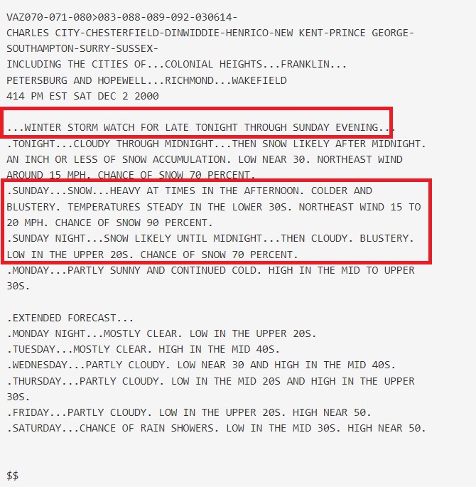
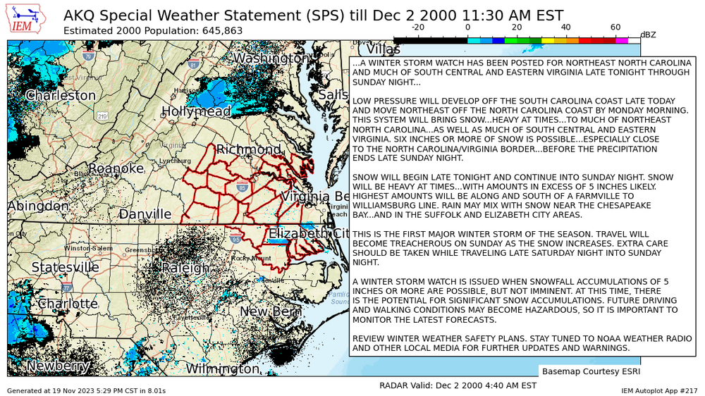
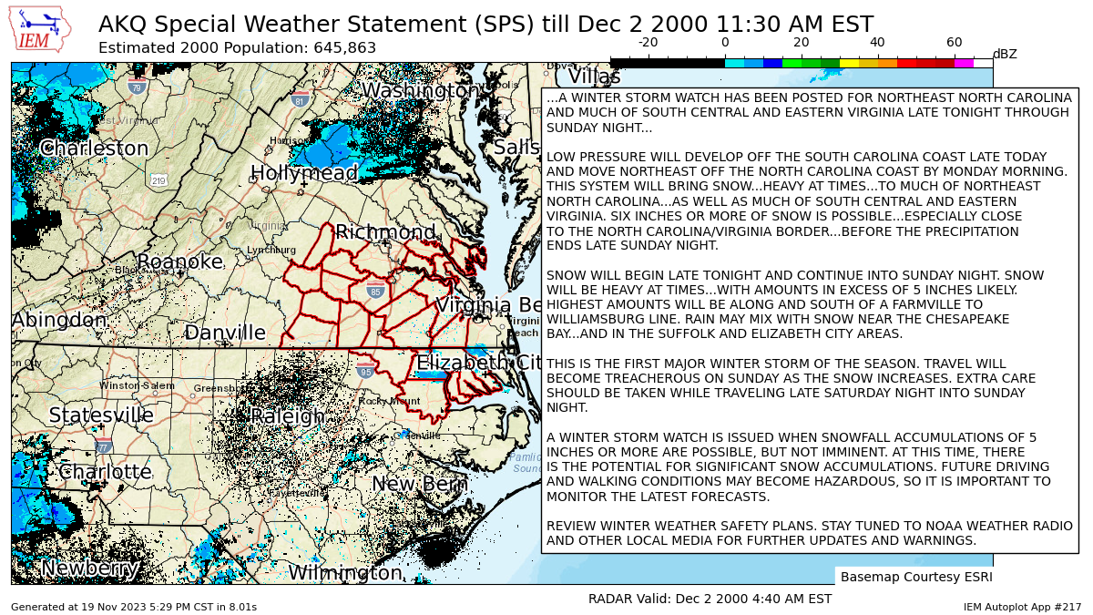
On 12/2/2023 at 1:23 PM, RIC Airport said:
This weekend marks the anniversary of the 12/3-4/2000 storm, which was a major disappointment for most of our area. I guess unless you live in Franklin, Ahoskie, Currituck areas.
") Many areas in NE NC received 10-15" of snow.
Many areas in NE NC received 10-15" of snow.
But, the storm was supposed to affect most of east central and SE VA. In fact, NWS Wakefield (as you can see below) even issued a winter storm watch as far N and W as the Richmond metro area. Unfortunately, in the final 24hours the models shifted the storm farther south. It could've been better region-wide, one of my worst memories being in Richmond at the time.
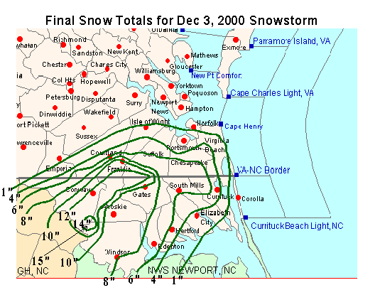
I remember that well with my snow flurries while 25 miles SW It was 10-12 inches
-
1
-
-
Last paragraph from Fairbanks discussion
Extended Forecast Days 4-7...
It looks to be much colder than we`ve seen lately and the coldest
of the season so far for many locations, especially the West Coast
and Western Interior Sunday night into Monday. The pattern looks
to consist of troughing over the state which would bring more in
the way of Arctic air to the West Coast and Western Interior with
some moderating and chances for Interior snow by midweek. Details
are still being ironed out and we will continue to monitor the
evolving pattern as it is volatile.
Its a bit below normal now. As long as they stay cold its going to be really hard for it to get cold here.
-
 1
1
-
2
-
-
The signs of a pattern change might be there but the cold air isnt
about the coldest time of day and nothing remarkable anywhere in the US

-
2
-
7
-
-
I would like to see Fairbanks warm up before i get too excited about cold here.
This AfternoonSnow, mainly before 3pm. High near 4. Calm wind. Chance of precipitation is 80%. Total daytime snow accumulation of less than one inch possible.TonightA 20 percent chance of snow before 9pm. Mostly cloudy, with a low around -5. Calm wind becoming northeast around 5 mph.ThursdayPartly sunny, with a high near 4. Calm wind becoming northeast around 5 mph.Thursday NightA 40 percent chance of snow, mainly after midnight. Mostly cloudy, with a low around -11. Calm wind.FridayA 50 percent chance of snow. Mostly cloudy, with a high near 0. Calm wind.Friday NightA 40 percent chance of snow, mainly before midnight. Mostly cloudy, with a low around -20.SaturdayPartly sunny, with a high near -9.Saturday NightA slight chance of snow after 3am. Mostly cloudy, with a low around -21.SundayA slight chance of snow. Partly sunny, with a high near -8.Sunday NightA slight chance of snow before 3am. Mostly cloudy, with a low around -17.MondayA slight chance of snow. Mostly cloudy, with a high near 3.Monday NightA slight chance of snow. Mostly cloudy, with a low around -5.TuesdayA slight chance of snow. Mostly cloudy, with a high near 3. -
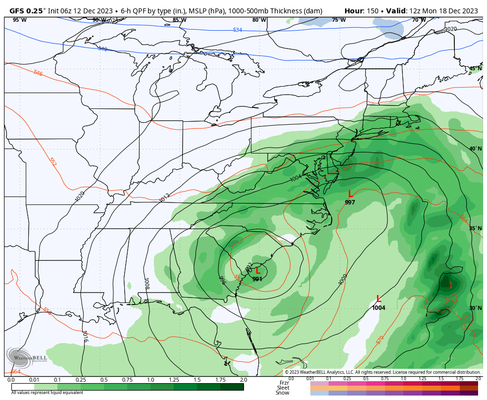
GFS went from winter storm to summer heat.
-
1
-
-
1 hour ago, pazzo83 said:
lmao does this moron know how hard it is to get NYC to 0? it's happened ONCE since 1994 and that (in 2016) was a fluke cold spell.
JAN 1994 was chilly in NYC with 3 lows of zero or colder
Maybe this is the beginning of the pattern change. We are not at the beginning of the end but the end of the beginning

First time the cold has dug in with a storm


-
6
-
-
39 minutes ago, WxUSAF said:
Maybe some members trying to kill the MJO prematurely in phase 6 or 7 vs continuing into 7-8-1? Dunno, just guessing/grasping at straws. Strat PV orientation doesn’t seem to jive with cold air in western North America, so not sure what would produce that.
JB says its coming
-
1
-
1
-
-
18Z also has this


AND it snows and snows and snows

-
5
-
6
-
-
This pattern will never work. 1 or 2 days of cool followed by rapid warm-ups. Nice for lake effect as it never gets so cold the lakes totally freeze up.

-
The problem is the cold is always a glancing blow. It needs to dive into the center of the country and spread east.
-
1
-
-
Hopefully it gets better
-
1
-
-

December Mid/Long Range Discussion
in Mid Atlantic
Posted
Another lt snow event possible?