

ldub23
-
Posts
1,924 -
Joined
-
Last visited
Content Type
Profiles
Blogs
Forums
American Weather
Media Demo
Store
Gallery
Posts posted by ldub23
-
-
7 minutes ago, Ed, snow and hurricane fan said:
Euro ensembles suggest an uptick in 7-10 days, but that has felt a little Charlie Brown and the football.
Near term and lower prob, zero GFS ensemble support, rather tepid Euro ensembles, a very weak wave now near 65W becomes a bit better defined in 3 1/2-4 days near W Cuba, maybe finds a small window of shear and dry air, TD or TS for N. Mexico or Deep South Texas.
The actual tropics are never favorable anymore whether its el nino, la nina or lo neutro
-
59 minutes ago, MANDA said:
At this point I'm rooting for a 0/0/0 August just because. SST's are not going to save the day on their own. While an August shutout is not likely at this point it is not too hard to envision. I agree, September will have to be off the charts to get to CSU's numbers.
Getting boring.
More signs

-
3 minutes ago, Ed, snow and hurricane fan said:
Verbatim, those 2 lows will be struggling bigly with dry ait.
Thats why its just a SIGN of life. Like the last few years nothing will be easy to develop.
-
 2
2
-
-
Related to my deleted post the euro shows some signs of life. The gfs at the end of its run shows a large high building in the Northeast that will change the pattern and allow the season to start IF the change actually happens and IF anything is around to develop.

-
At least the euro is showing some signs of life

-
2
-
-
17 minutes ago, Ed, snow and hurricane fan said:
I am curious what data made the models yesterday and lasr night that had them (and especially the ensembles) bullish for development a week to two weeks out, when they had not been seeing much TC activity before, and again today. It wasn't just one model suite. Maybe the lesson is I need two full days of multiple model enthusiasm. Maybe three, before I buy in.
If we could ever have a reasonably favorable MDR the lower right would be very interesting

-
13 hours ago, Ed, snow and hurricane fan said:
Bed time, GFS is out 8 days, and the only thing that stops a tropical depression from forming in the Caribbean (in an El Nino year, at that) is the Nicaraguan coast. Not shear, not dry air. See post on steering from 12 hours ago, this wave probably got there too soon, but personally, my low chance (say 20%) is now 30%, and maybe after tomorrow's 12Z run, I'll go full 40% orange.

GFS has a TS and cane after that, maybe it will get more active
Less active. Looking at another 0/0 aug. In close development not possible with a mega trof.

-
1
-
 1
1
-
-
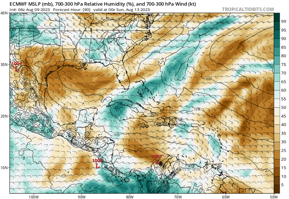
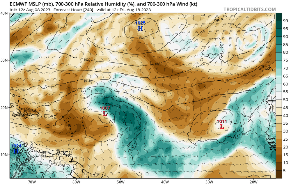
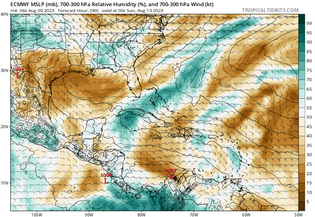
11 hours ago, GaWx said:
Based on the 12Z model consensus, my biggest concern for at least the next two weeks for the CONUS is for the period August 13-17, when the Bermuda high/WAR looks strongest, which may make it hard for a safe recurve. During that period, the model/ensemble consensus is suggesting that what's now coming off Africa will merge with energy/moisture now near 30-35W and likely move quite far west in the MDR at a very much up in the air strength (could end up being just a vigorous tropical wave). Bears watching.
JB agrees
First wave and threat to the US looks to be about 10 days off. at 500 mb pattern the period Aug 20-30 looks to be very close to analogs of major hits from 2003-2022. Painstakingly went over every map to come up for analog Euro has enhanced eastern threat day 11-18 -
The Ukmet forcast issued today. Since there are no modeled hurricanes up to aug 17 i suppose sept is going to be one hellova month. TWC 10/5 CSU 9/4 UKMET9/6
215 ace? I think 65 will be closer to reality.
JB is continuing to backtrack while others go wild with super active forecasts.
Issued 01 August 2023
All values given below represent observed activity for the 6-month period from February to July 2023 plus the 6-month GloSea6 forecast activity from August 2023 to January 2024. Note, the official tropical storm season, which usually includes most activity, is from June-November.
The most likely number of named tropical storms (winds of at least 39 mph) predicted to occur in the North Atlantic is 19, with a 70% chance that the number will be in the range 14 to 24. The 1991-2020 long-term average is 14.
The most likely number of hurricanes (winds of at least 74 mph) predicted to occur in the North Atlantic is 9, with a 70% chance that the number will be in the range 6 to 12. The 1991-2020 long-term average is 7.
The most likely number of major hurricanes (winds of at least 111 mph) predicted to occur in the North Atlantic is 6, with a 70% chance that the number will be in the range 3 to 9. The 1991-2020 long-term average is 3.
An ACE index of 215 is predicted as the most likely value, with a 70% chance that the index will be in the range 120 to 310. The 1991-2020 average is 123. -
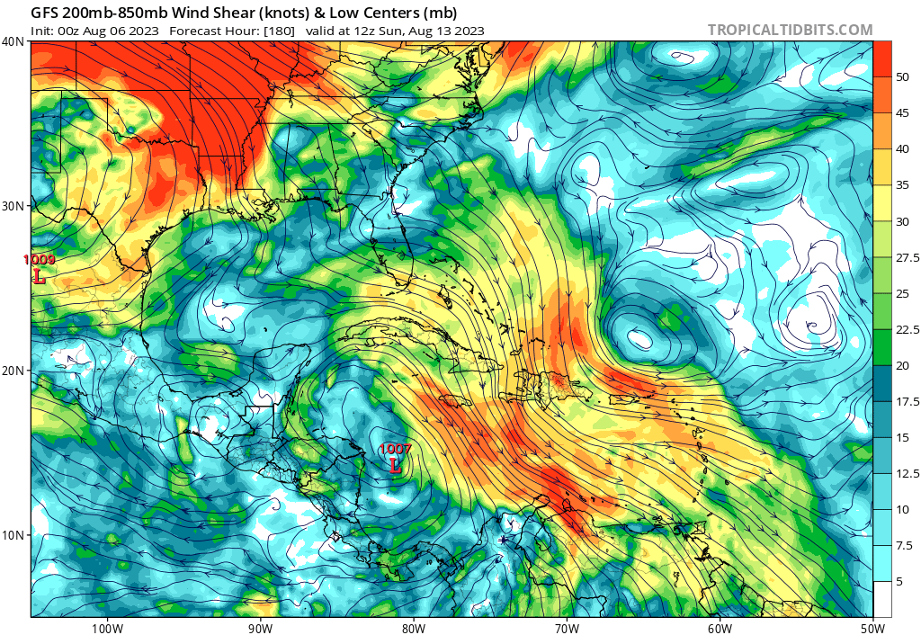
This is why the ATL tropics will have a really hard time getting started. Once again we have a low of non tropical origin from a front off the east coast move east across the atlantic. It will kill any chance of the season geting started as anything to its south in the MDR has no chance.

Looks like the lights have gone out on the NW ATL. JB backtracking as things are deader than dead. SST's are the least important factor.
Until the WPAC calms down, the Atlantic is not likely to rev up. Slow moving major typhoon weakens in a few days as it turns away from China but may still be on the charts 10 days from now -
1 hour ago, Normandy said:
People agree with the NHC in this? That looks like a TC to me
Frontal low. Why waste a name for a low on a front?
Looks like JB nailed it again. The west atl is lighting up. It forms from a non tropical low east of bermuda.

-
1
-
-
21 minutes ago, Ed, snow and hurricane fan said:
Euro weeklies the last week do seem to see an enhanced risk the end of August along and offshore ECUSA. Weekly 500 hPa forecast Not shown) for that time, the trough is over the Central/Eastern Lakes down into the Appalachians, with higher than normal heights in the Canadian Maritimes.

High pressure in the Candian maritimes would be what we need to get anything past 70w or for inclose development.
-
Wasnt 1997 deader than dead? But to be optimistic JB is saying it again. WATCH OUT mid-atlantic
-
19 hours ago, Ed, snow and hurricane fan said:
Nothing on the Euro or GFS ensembles after 96L and the possible off the Carolinas sub-tropical system. If anything develops 10-15 days out, I'd guess it'd be subtropical. 8/21 to 8/28, a small signal on the Euro weeklies for something off the ECUSA.
Speaking of 96L, SHIPS is as optimistic as any intensity guidance gets, and that is barely Cat 1 intensity.
Except for 2 weak lows GFS is dead thru the middle of AUG. Is the season ever going to get started?
-
4 hours ago, Ed, snow and hurricane fan said:
Double the usual expected ACE for the week of 8-21 to 8-28 per today's Euro weeklies. TC probs, the weeklies see 96L but aren't seeing the EC sub-tropical development the ensembles clearly see. Maybe it does see it in the rainfall anomalies, but not in the TC percentages. About the week of 8-21, perhaps hints of Florida being affected in rainfall anomalies.
Looks interesting
-
5 hours ago, jconsor said:
Regarding the Bahamas/FL system... yes, pressures are high and this will need some time to "cook" before developing. However, it going just inland next day or two is not a guarantee against a TD or weak TS developing. We have seen such systems develop even with little model support a few times in the recent past.
There is another brief window for development early next week as it heads back offshore and passes near the Gulf Stream:
You are right about the area near FLA. A little more time and it might do something. After the front passes Sunday it will be interesting to see if the pattern has changed to a 1954 like pattern.

-
14 hours ago, Ed, snow and hurricane fan said:
As long as fronts can stall and decay E of Florida, ECUSA is not 100% safe. No model support for today's Bahamas blob, but it probably isn't the last Bahamas blob of the year.
Even an MDR system could miss the trough. Last two weeks of Euro weeklies have a >5% TC chance along ECUSA.
The pattern will have to change to a locked in high over the NW ATL to see development of interest in the SW ATL. JB must have seen the weeklies as he is saying the east coast will face threats in mid to late Aug. Luckily the GFS is much weaker this AM with the recurver.
-
What is your wildest swing in weather? Feb 1989 comes to mind in SE VA. 80 degrees on the 15th, 13.6 inches of snow on the 18th, 76 degrees on the 21st and 8.6 inches of snow on the 24th
Sum 1462 981 - - 601 9 5.80 24.4 - Average 52.2 35.0 43.6 -0.6 - - - - 1.2 Normal 53.4 35.1 44.2 - 582 1 2.90 1.5 - 1989-02-01 72 46 59.0 16.7 6 0 0.00 0.0 0 1989-02-02 80 52 66.0 23.6 0 1 0.00 0.0 0 1989-02-03 81 41 61.0 18.5 4 0 0.11 0.0 0 1989-02-04 41 33 37.0 -5.6 28 0 0.02 0.0 0 1989-02-05 38 34 36.0 -6.7 29 0 0.64 0.0 0 1989-02-06 45 37 41.0 -1.8 24 0 0.18 0.0 0 1989-02-07 45 35 40.0 -3.0 25 0 0.12 0.0 0 1989-02-08 43 36 39.5 -3.6 25 0 0.00 0.0 0 1989-02-09 37 20 28.5 -14.7 36 0 0.00 0.0 0 1989-02-10 40 19 29.5 -13.9 35 0 0.00 0.0 0 1989-02-11 53 26 39.5 -4.0 25 0 0.00 0.0 0 1989-02-12 55 30 42.5 -1.2 22 0 0.00 0.0 0 1989-02-13 57 34 45.5 1.6 19 0 0.02 0.0 0 1989-02-14 77 56 66.5 22.5 0 2 0.00 0.0 0 1989-02-15 80 62 71.0 26.8 0 6 0.00 0.0 0 1989-02-16 67 41 54.0 9.6 11 0 T 0.0 0 1989-02-17 43 30 36.5 -8.1 28 0 0.15 1.2 0 1989-02-18 35 29 32.0 -12.7 33 0 1.33 13.6 7 1989-02-19 38 26 32.0 -12.9 33 0 0.18 0.6 9 1989-02-20 50 24 37.0 -8.1 28 0 0.04 0.0 4 1989-02-21 76 44 60.0 14.7 5 0 0.49 0.0 0 1989-02-22 60 43 51.5 6.0 13 0 0.21 0.0 0 1989-02-23 43 36 39.5 -6.2 25 0 0.16 0.4 0 1989-02-24 36 26 31.0 -14.9 34 0 1.03 8.6 3 1989-02-25 36 21 28.5 -17.6 36 0 0.00 0.0 7 1989-02-26 50 29 39.5 -6.8 25 0 0.00 0.0 3 1989-02-27 44 36 40.0 -6.5 25 0 0.41 T 0 1989-02-28 40 35 37.5 -9.2 27 0 0.71 0.0 0 Observations for each day cover the 24 hours ending
at the time given below (Local Standard Time).Max Temperature : midnight Min Temperature : midnight Precipitation : midnight Snowfall : unknown Snow Depth : unknown -
4
-
-
3 hours ago, GaWx said:
^rainstorm trolling 101 has worked well for two decades (this is part of the playbook) but regardless IF it actually develops into a TD, I wouldn't argue against very good chance it would then get to H status with MH quite possible. An impressive 17 of 31 0Z GEFS members, by far the highest yet, had a cane.
My forecast method is a simple one. Since it is now forecast to recurve east of bermuda and amount to nothing development is a lock.
-
 2
2
-
-
81% certain the east atl dist will develop into a cane
-
2
-
-
On 7/24/2023 at 6:13 PM, WEATHER53 said:
As far as cold day it was that one in 1994 where I had a high of 11 at 11am and at 5pm it was 1 above zero, overnight low of -6
as far as a length of time, probably the back to back Cold Sundays 1982
as far as wind chill, inauguration eve 1985.
as far as a month, January 1977
Probably wont see a month like that again soon with an avg low of 17 degrees here
Sum 1170 527 - - 1160 0 3.29 12.1 - Average 37.7 17.0 27.4 -12.4 - - - - 0.4 Normal 49.1 30.6 39.8 - 780 0 3.77 1.7 - 1977-01-01 34 15 24.5 -16.1 40 0 0.00 0.0 0 1977-01-02 37 15 26.0 -14.5 39 0 0.00 0.0 0 1977-01-03 35 19 27.0 -13.4 38 0 0.00 0.0 0 1977-01-04 40 28 34.0 -6.3 31 0 0.01 0.0 0 1977-01-05 38 24 31.0 -9.2 34 0 0.18 2.8 3 1977-01-06 36 17 26.5 -13.6 38 0 0.00 0.0 T 1977-01-07 40 28 34.0 -6.0 31 0 0.57 5.8 2 1977-01-08 45 14 29.5 -10.5 35 0 0.00 0.0 2 1977-01-09 39 17 28.0 -11.9 37 0 T 0.0 T 1977-01-10 48 19 33.5 -6.3 31 0 1.24 0.5 T 1977-01-11 38 17 27.5 -12.3 37 0 0.00 0.0 T 1977-01-12 36 10 23.0 -16.7 42 0 0.00 0.0 T 1977-01-13 31 12 21.5 -18.2 43 0 0.00 0.0 T 1977-01-14 33 20 26.5 -13.1 38 0 0.46 0.0 T 1977-01-15 39 30 34.5 -5.1 30 0 0.49 0.0 T 1977-01-16 32 25 28.5 -11.1 36 0 0.11 1.5 2 1977-01-17 26 0 13.0 -26.6 52 0 0.00 0.0 1 1977-01-18 26 6 16.0 -23.5 49 0 0.00 0.0 1 1977-01-19 31 1 16.0 -23.5 49 0 0.00 0.0 T 1977-01-20 37 11 24.0 -15.5 41 0 0.00 0.0 T 1977-01-21 35 12 23.5 -16.1 41 0 0.00 0.0 T 1977-01-22 32 14 23.0 -16.6 42 0 0.00 0.0 T 1977-01-23 34 10 22.0 -17.6 43 0 0.00 0.0 T 1977-01-24 38 20 29.0 -10.6 36 0 0.16 1.5 2 1977-01-25 40 24 32.0 -7.7 33 0 0.07 0.0 T 1977-01-26 41 20 30.5 -9.2 34 0 0.00 0.0 T 1977-01-27 49 31 40.0 0.2 25 0 0.00 0.0 T 1977-01-28 55 30 42.5 2.7 22 0 0.00 0.0 T 1977-01-29 55 11 33.0 -6.9 32 0 0.00 0.0 T 1977-01-30 35 6 20.5 -19.5 44 0 0.00 0.0 T 1977-01-31 35 21 28.0 -12.0 37 0 0.00 0.0 T Reliable observation times are not available prior to 1982. -
1
-
-
JB says it again, brings up 1954 and we all know how that year was for the east coast. In other tweets he remains confident of east coast threats. Im pretty sure he meant to type 3 or more days of 90+
-
3
-
-
12 minutes ago, jconsor said:
Thread about the next potential MDR/central Atlantic system. Of course it's very early and the system isn't expected to form for another 5-7 days, but I though it's worth discussing potential track. I'm not so sure this will form as early as ensembles imply. Given the indications of a weakening E US trough/building W Atl ridge first week of Aug, this could work against a clean recurve out to sea.
The pattern does appear to be changing. Hopefully it lasts thru OCT.
-
39 minutes ago, jconsor said:
Need to watch for possible development near the SE US coast late this week into this weekend.
If it does develop it will correspond to a brief change in the pattern with the rain stopping for a few days.

2023 Atlantic Hurricane season
in Tropical Headquarters
Posted