

psv88
-
Posts
14,003 -
Joined
-
Last visited
Content Type
Profiles
Blogs
Forums
American Weather
Media Demo
Store
Gallery
Posts posted by psv88
-
-
25 minutes ago, NorthShoreWx said:
Or FTL. But it does seem to have happened.
Ha i spoke too soon. Steady snow now over the island.
Sound effect snow in full effect now. Will add up to noting haha.
-
1 minute ago, Great Snow 1717 said:
FYP
December 2027
-
 1
1
-
 1
1
-
-
2 minutes ago, Great Snow 1717 said:
I live in NE Mass,there hasn't been a morning temp below 11 degrees..
12 has been my low here. Nothing suggests we get colder by seasons end.
-
 1
1
-
 1
1
-
-
Just saw a few flurries. 36 out. Long Island upslope FTW?
-
1
-
-
Just checked my records, it’s been 6 days since we dropped below freezing in late January. Pretty awful
-
2
-
-
Sign of a garbage winter: arguing about WHY the pattern sucks lol. Who cares
-
2
-
3
-
-
Can’t remember the last time we went below freezing. Maybe a week ago?
-
2
-
1
-
-
9 minutes ago, Brian5671 said:
Short term models were too cold for areas south of I 84 yesterday
WTTTE
-
Currently 33 in Montreal and Toronto, goes to show what a terrible airmass this is
-
1
-
-
11 minutes ago, Dark Star said:
? Most of any future precip will likely retrograde back from the north?
Yup. Hence the sound enhancement. BL definitely too warm for accums on the island
-
1 hour ago, NorthShoreWx said:
NEAR TERM /THROUGH MONDAY/... Mid-level dry across the area has resulted in mainly drizzle and/or light rain for the afternoon hours, but every now and then a heavier pocket may mix with sleet and/or snow as verified by mPING reports. The upper low/trough will move across the area and precipitation should fill back in with a moistening vertical profile. Expect the snow growth region (-10 to -20C) to moisten and rain to transition to snow through the night with even a rain/snow mix getting down to the coast during the early morning hours. However, temperatures are forecast to generally be above freezing through the night with the possible exception of higher elevations across inland areas. Precipitation will generally be light, so any accumulations should be minor. Liquid equivalent overnight into Monday will be about a 0.25". Also interesting to note, as surface low pressure passes to the south and east, gusty NE winds will become more northerly through the night. For Long Island, this will be off the Long Island Sound. Multiple high res models are picking on a west to east enhancement in the precipitation across Long Island. This is due to a moist upslope component which has been noted in past events. It doesn`t take much elevation to help squeeze out a bit more. This may be enough to provide a coating of snow across this area.
LFG. lol
upslope snow on LI to nickel and dime to 6” of snowfall? My god are times tough
-
1
-
-
6 minutes ago, wishcast_hater said:
Flipped to snow here. Big fat flakes, ground whitening. Very surprised at this. I figure I wouldn’t have see snow until about 4 pm
.Why? Your area was and is forecast to have snow at this time. Shouldn’t be a surprise
-
Another beautiful day here in Seattle
-
3
-
1
-
-
January 27 and 5” of snow for the season. Based on this board I should have had 4 feet of snow by now. People need to realize a good pattern on paper doesn’t mean it will snow. Once people get that concept the overhyping will stop. It’s the overhyping that kills weather boards these days more than anything.
-
2
-
 1
1
-
2
-
-
30 minutes ago, donsutherland1 said:
HREF:
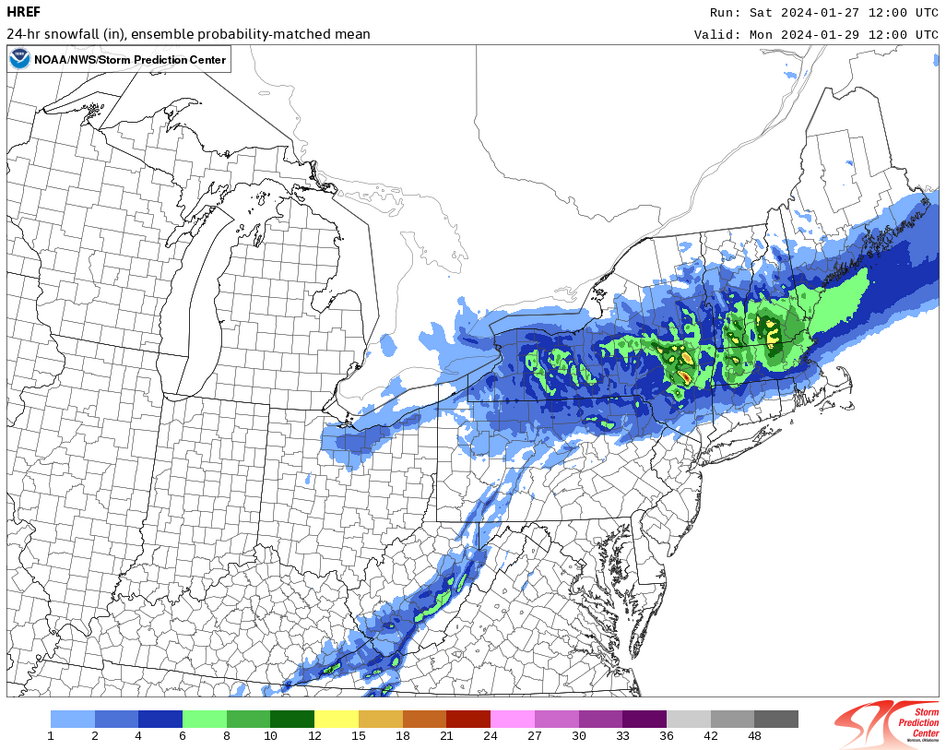
Good for Boston! I’d prefer this cloudy and misty weather over a moderate snowfall event in peak climo…
-
1 minute ago, bluewave said:
Looks like the 3rd cloudiest January on record at ISP using the 9am observation time.

Thank you. It has been a terrible 9 months for clouds/smoke sky.
-
1
-
-
No sun tomorrow now. So no sun until Tuesday now.
this has to be one of the cloudiest winters ever? @donsutherland1
-
1
-
-
More rain! Excellent!
-
2
-
-
57 today. Sweet.
-
56 right now. Was 55 last year this date.
-
2
-
3
-
-
4 minutes ago, the_other_guy said:
I feel like I should be under a dense fog advisory. Very surprised that I’m not.
Well under a quarter of a mile here
We have one here.
-
1
-
-
29 minutes ago, MJO812 said:
Yep hopefully it's a blip.
Onto 0z
You know you are again chasing ghosts right? This has New England written all over it, not south Brooklyn
-
1
-
-
5 minutes ago, dseagull said:
So, just for informative purposes.... (because clearly the weenies are stacking up...,) what does that reaction mean?
Am I unwelcome here for sharing photos of enjoyment in the snow?
I always assumed that discussions that strayed from like-minded opinions were unwelcome here, but sheesh.
I've learned a lot here, as have others from my companies.
Guess I'll go on my weenie-way. Good luck all!
Everyone gets the weenie emoji. It’s a sign of love…stick around…
-
2
-
1
-
-
We won’t see the sun until Saturday and then rain again Sunday and Monday
-
1
-


Sunday 1/28-midday Monday 29/2024 snowfall and OBS most of the NYC subforum including potential 1/2-2" NYC-LI-heavier toward I84.
in New York City Metro
Posted
Actually a nice burst of snow just to your east. Building west a bit?