

psv88
-
Posts
13,989 -
Joined
-
Last visited
Content Type
Profiles
Blogs
Forums
American Weather
Media Demo
Store
Gallery
Posts posted by psv88
-
-
7 minutes ago, LibertyBell said:
why aren't we getting northwesterly flow behind storms to clear the skies out like we usually do?
Because Taylor Swift
-
 2
2
-
-
26 minutes ago, bluewave said:
Close to the cloudiest January since 1973 on Long Island at 63% now.

Horrific.
-
 1
1
-
-
17 minutes ago, NorthShoreWx said:
Anchorage averaging 2.6°F below normal for both December and January and snowfall has been more than twice normal. They had a 16" snowfall this week, which is a biggy for Anchorage and current snow depth is 37". Plus they might come close to some record lows over the next week.
When Alaska is cold we are warm and the reverse is true as well
-
 1
1
-
-
Didn’t even hit freezing last night.
-
What the hell. Point and click said partly cloudy this week and now cloudy until Friday!
WHERE IS THE SUN??!??!?
-
At Topgolf in holtsville by @Rjaybeen snowing for an hour
-
3
-
-
1 minute ago, qg_omega said:
Not boring…..Not
At least Mexico can cash in
-
3
-
-
29 minutes ago, JerseyWx said:
Absolutely. I've said it several times but all summer and fall has been very wet and gloomy. We need a pattern shift this spring.
And the wildfire smoke!! Awful
-
1
-
-
Yea people are losing their minds over the lack of sunshine. This has been a truly horrific month.
-
2
-
1
-
-
Congrats guys, another NW event. Cashing in this winter
-
1
-
-
2 minutes ago, jm1220 said:
Final total in Boston looks like it was 0.3”. No moderate event for them either.
 What a pathetic storm in a pathetic winter.
Actually a nice burst of snow just to your east. Building west a bit?
-
25 minutes ago, NorthShoreWx said:
Or FTL. But it does seem to have happened.
Ha i spoke too soon. Steady snow now over the island.
Sound effect snow in full effect now. Will add up to noting haha.
-
1 minute ago, Great Snow 1717 said:
FYP
December 2027
-
1
-
 1
1
-
-
2 minutes ago, Great Snow 1717 said:
I live in NE Mass,there hasn't been a morning temp below 11 degrees..
12 has been my low here. Nothing suggests we get colder by seasons end.
-
1
-
1
-
-
Just saw a few flurries. 36 out. Long Island upslope FTW?
-
1
-
-
Just checked my records, it’s been 6 days since we dropped below freezing in late January. Pretty awful
-
2
-
-
Sign of a garbage winter: arguing about WHY the pattern sucks lol. Who cares
-
2
-
3
-
-
Can’t remember the last time we went below freezing. Maybe a week ago?
-
2
-
1
-
-
9 minutes ago, Brian5671 said:
Short term models were too cold for areas south of I 84 yesterday
WTTTE
-
Currently 33 in Montreal and Toronto, goes to show what a terrible airmass this is
-
1
-
-
11 minutes ago, Dark Star said:
? Most of any future precip will likely retrograde back from the north?
Yup. Hence the sound enhancement. BL definitely too warm for accums on the island
-
1 hour ago, NorthShoreWx said:
NEAR TERM /THROUGH MONDAY/... Mid-level dry across the area has resulted in mainly drizzle and/or light rain for the afternoon hours, but every now and then a heavier pocket may mix with sleet and/or snow as verified by mPING reports. The upper low/trough will move across the area and precipitation should fill back in with a moistening vertical profile. Expect the snow growth region (-10 to -20C) to moisten and rain to transition to snow through the night with even a rain/snow mix getting down to the coast during the early morning hours. However, temperatures are forecast to generally be above freezing through the night with the possible exception of higher elevations across inland areas. Precipitation will generally be light, so any accumulations should be minor. Liquid equivalent overnight into Monday will be about a 0.25". Also interesting to note, as surface low pressure passes to the south and east, gusty NE winds will become more northerly through the night. For Long Island, this will be off the Long Island Sound. Multiple high res models are picking on a west to east enhancement in the precipitation across Long Island. This is due to a moist upslope component which has been noted in past events. It doesn`t take much elevation to help squeeze out a bit more. This may be enough to provide a coating of snow across this area.
LFG. lol
upslope snow on LI to nickel and dime to 6” of snowfall? My god are times tough
-
1
-
-
6 minutes ago, wishcast_hater said:
Flipped to snow here. Big fat flakes, ground whitening. Very surprised at this. I figure I wouldn’t have see snow until about 4 pm
.Why? Your area was and is forecast to have snow at this time. Shouldn’t be a surprise
-
Another beautiful day here in Seattle
-
3
-
1
-

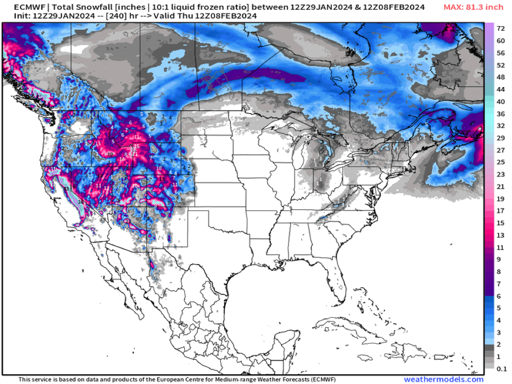
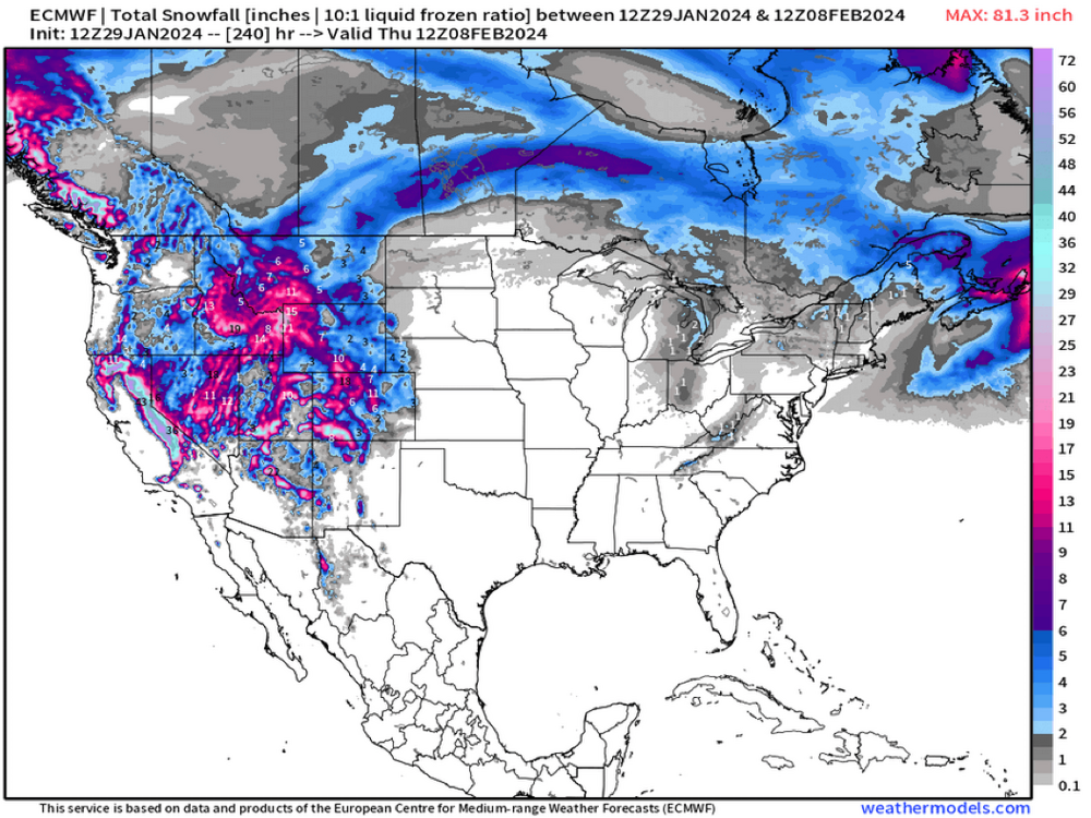
January 2024
in New York City Metro
Posted
Still above freezing