

psv88
-
Posts
14,006 -
Joined
-
Last visited
Content Type
Profiles
Blogs
Forums
American Weather
Media Demo
Store
Gallery
Posts posted by psv88
-
-
5 minutes ago, dseagull said:
So, just for informative purposes.... (because clearly the weenies are stacking up...,) what does that reaction mean?
Am I unwelcome here for sharing photos of enjoyment in the snow?
I always assumed that discussions that strayed from like-minded opinions were unwelcome here, but sheesh.
I've learned a lot here, as have others from my companies.
Guess I'll go on my weenie-way. Good luck all!
Everyone gets the weenie emoji. It’s a sign of love…stick around…
-
 2
2
-
 1
1
-
-
We won’t see the sun until Saturday and then rain again Sunday and Monday
-
 1
1
-
-
23 minutes ago, MJO812 said:
Can someone please change my name back. Thank you.
Why can’t you change your own name?
-
1 minute ago, WestBabylonWeather said:
Metfan was right.
Who is Metfan? All we are left with is MJO who jinxed us with his dumb name change
-
 3
3
-
-
Heavy frost this morning.
-
1
-
-
12 this morning. Today the melt begins
-
2
-
-
We’re getting 60s this week?
-
2
-
-
It was 4 degrees 5 years ago this date , and 58 degrees 7 years ago. This is at my PWS.
-
1
-
 2
2
-
-
14, coldest of the season and maybe that’s the coldest temp this winter?
-
2
-
-
52 minutes ago, the_other_guy said:
you are over analyzing it. There’s not enough natural elements in New York City. It’s too large of a concrete jungle. that does not do well in a warming climate.
The things you mention apply to the coastal areas of Long Island just fine. But there’s a reason why the rest of the region has snow and there’s a giant hole over New York City and it’s called overdevelopment that holds heat and a rapidly warming climate.
Frankly, I expect it to continue. All those warm overnights ( plus 10 to 15 from the surrounding areas) were leading to this.
I would love if somebody had some data from China or some other tightly packed Asian countries with huge cities to see if something similar is going on there.
Long story short, I don’t think this is a natural phenomenon, but a man-made phenomenon interacting with a man-made warming situation. It just doesn’t get cold in New York City for any prolonged period of time anymore and it’s not gonna snow under those circumstances.
But if you go 20 miles north or east or west or even south, you see much less of an example of this
The south shore of Long Island is the worst of both worlds. Southern Nassau and SW Suffolk are highly developed as well and have their own heat island. In addition, they have near zero elevation and right on the warm Altantic. Worst possible combination for consistent snowfall.
north shore elevation between 150-350 feet, much less developed, further north and gets sound enhancement. In marginal storms it makes a massive difference. I do agree that heat island also plays a large role even in the burbs
-
1
-
-
26 minutes ago, wdrag said:
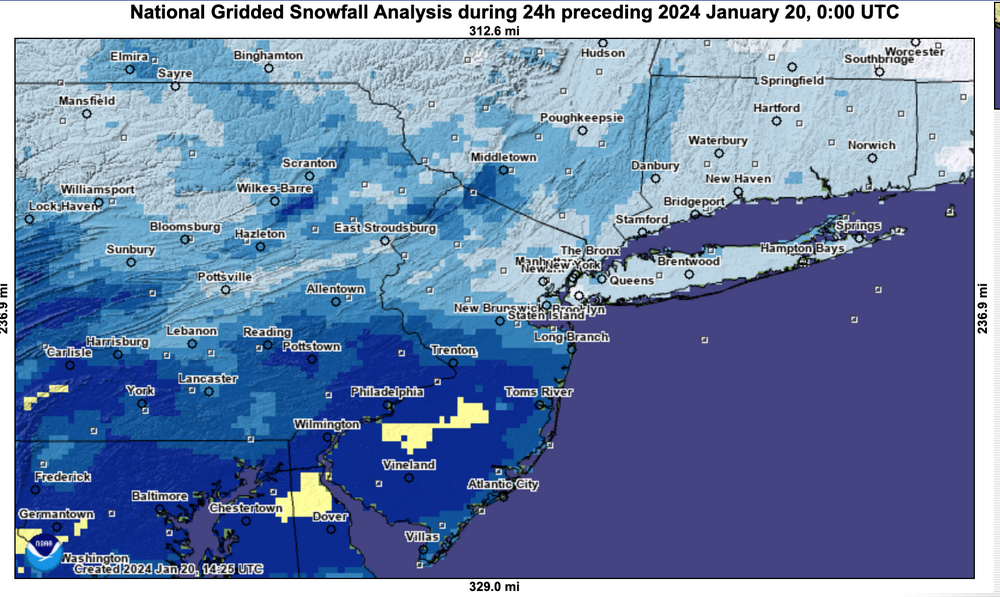
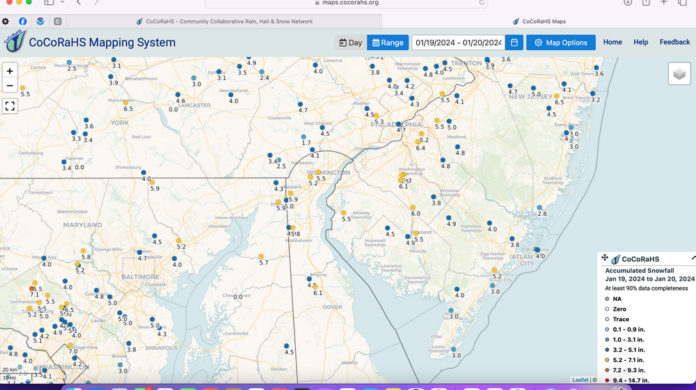
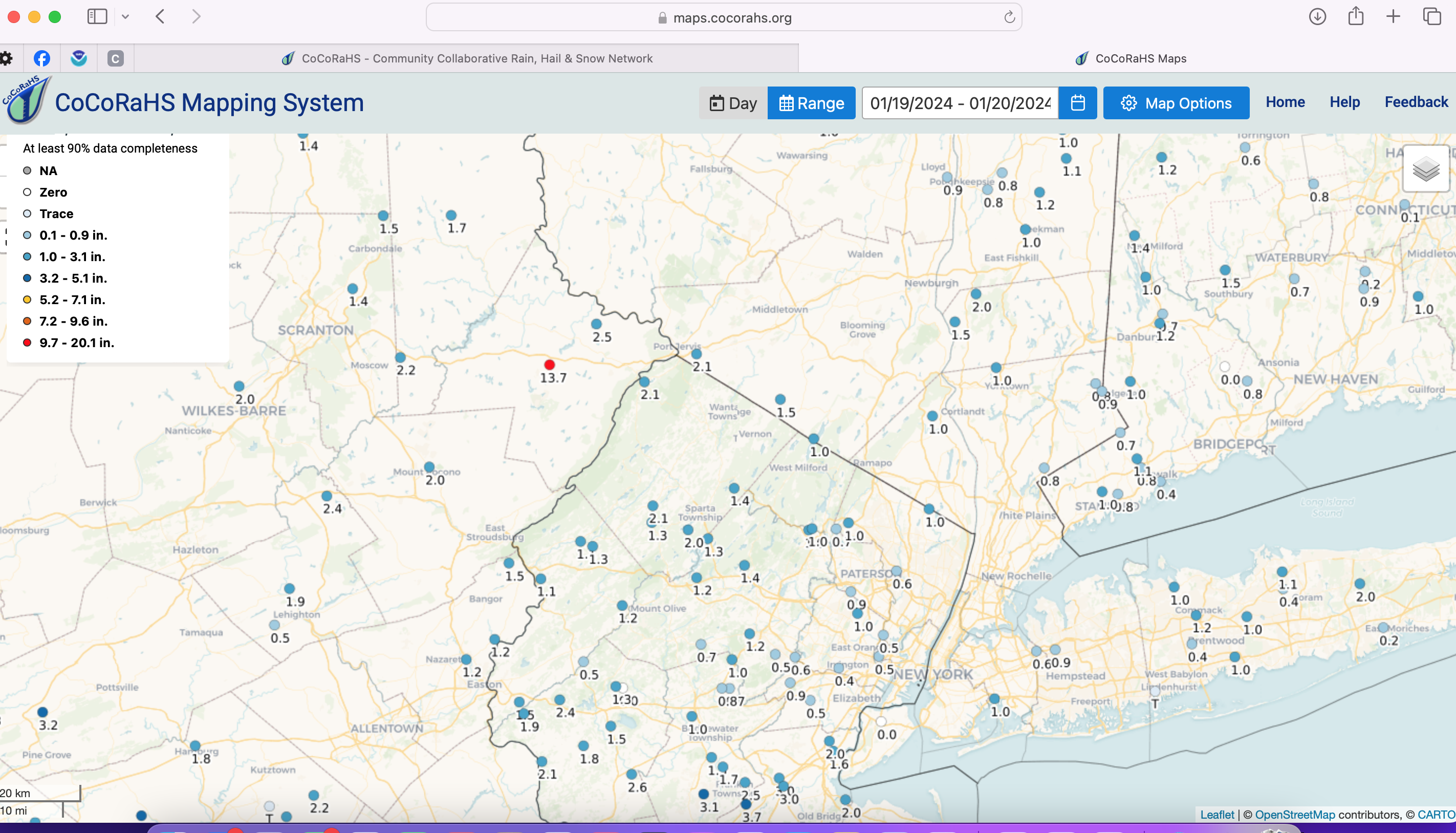
Summary 1/19/24 event: Variable 1-3" snowfall in the sNYC ubforum with less than 1" parts of Li/NYC area and 3" or more high terrain around the Northwest edge per satellite-human interface. General 3-6" DCA-BWI-PHL up to near or just south of I78. GEFS best modeled snowfall upon thread initiation (Sunday the 14th) and overall 5 day target was decent with a tendency for modeling southward slippage toward MD as T0 (Friday the 19th) drew closer.
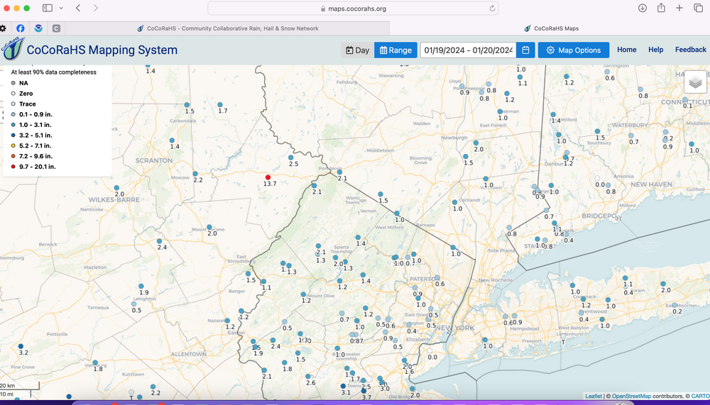
North shore of Nassau and Suffolk is underdone. Many areas 1.5-2.0” of snow. I probably had closer to 2” but didn’t measure until late
actually have a decent pack on the ground now
-
1
-
2
-
-
15 in Suffolk. Deep winter out there
-
2
-
-
3 minutes ago, LibertyBell said:
funny how the south shore of long island does poorly even when further south does better lol
North shore got some sound enhancement today with the north wind. That enhancement dies out south of the LIE
-
2
-
1
-
-
2 hours ago, Rjay said:
2.7ish here on the season
Got 3” on the ground now. You shouldn’t have moved to southeast Suffolk
-
1
-
-
1.5” final, 5” even on the season
-
2
-
1
-
-
2 minutes ago, WestBabylonWeather said:
Coming down now at kings park bluff. Drove up here for the band lol
Enjoy. Last snow for a long time. Roads in my hood becoming snow covered
-
1
-
-
Temp dropping down to 27 and a final snow band now. We will end up with 1.5” new
-
Just now, jm1220 said:
Wouldn’t have thought the north shore would do better than south today. But alas….
Yea these bands keep developing and swinging east north of the LIE
-
This storm brings me up to 4.5” on the season. Pretty bad!
-
1
-
1
-
-
2 minutes ago, weatherpruf said:
Oh it’s really pathetic here. But it’s all we got. Just seen a plow go by and a salter and have no idea what they were plowing. I did take the snow blower out of mothballs in the hopes for 3 inches but it will not be needed.
I may have to put fuel stabilizer in my snowblower at this rate
-
1.25” in NW Suffolk. Maybe we squeeze out another .25”
-
1
-
-
Heavy snow now in north shore of Suffolk’s. Old snow has close to an inch on it. Well probably make a run at 2
-
1
-
-
2 minutes ago, WestBabylonWeather said:
Looks like south shore will get into it soon
Snow developing over the island now. I think the next 2 hours is our main show to squeeze out an inch or so.
-
2
-
-
Probably half 1/2” of new out here already. So either we will over perform or this is it lol

Sunday 1/28-midday Monday 29/2024 snowfall and OBS most of the NYC subforum including potential 1/2-2" NYC-LI-heavier toward I84.
in New York City Metro
Posted
You know you are again chasing ghosts right? This has New England written all over it, not south Brooklyn