
TriPol
-
Posts
1,873 -
Joined
-
Last visited
Content Type
Profiles
Blogs
Forums
American Weather
Media Demo
Store
Gallery
Everything posted by TriPol
-
I'm nervous about this storm. 50 miles East and NYC gets advisory level snow. 50 miles west and it's a major KU. There's almost no room for error.
-
Bill Evans Weather Forums -> EasternUS -> AmericanWX I tried Accuweather for like a day, but everyone was like WeatherGeek. So I left.
-
If this verifies, we're calling it the WeatherGeek blizzard of 2026.
-
This isn't a terrible place to be 48 hours out.
-
They've always been conservative.
-
Another 50 miles NW and we're locked in.
-
Dude’s brand new and already trashing everyone. Go back to accuweather forums.
-
POV: You're too much of a weather weenie for a forum full of weather weenies.
-
Annnd this is why I had someone else into starting the thread. My record is still intact.
-
Remember, the last storm showed suppressed to the south until Weds-Thurs and then it moved so far north we got sleet.
-
Onto Spring!
-
.thumb.jpeg.55dc99e9b73a9205b02d54d562973dac.jpeg)
-
-
Great comment.
-
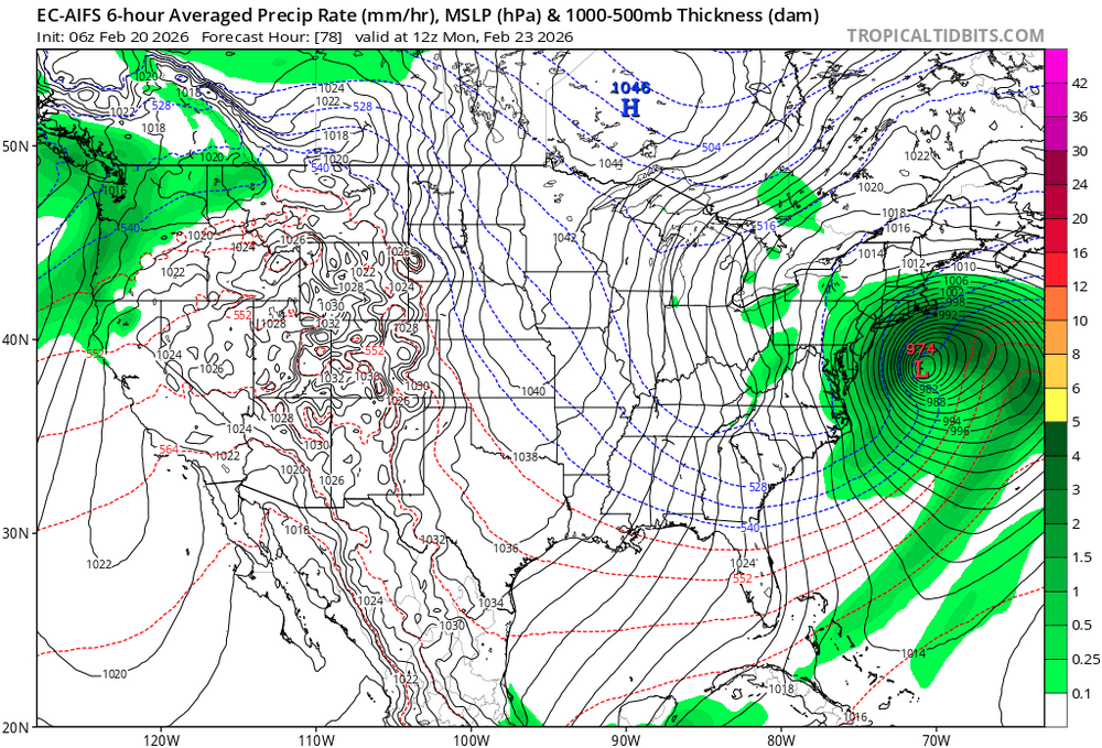
We shall see what the 12z model suite has in store for us. Alternatively, I've never seen donsutherland1 start a thread before. Would love to see him start one.
-
If 12z GFS and 12z EURO is on board... I reserve the right to respond. We need a good coastal bomb to close out this winter.
-
It's Monday. Storm moves in on Saturday. We have 24 model run cycles left. Someone should definitely start a thread by Wednesday at the latest.
-
Tempted to start a thread...
-
Congrats kid. Good work on deleting your 2-4 inch post.
-
Can you send me a link with the totals? I'm not seeing the totals anywhere. https://forecast.weather.gov/product.php?site=NWS&issuedby=OKX&product=PNS&format=txt&version=1&glossary=0
-
https://www.weather.gov/wrh/timeseries?site=KNYC Feb 16, 6:51 am 30 26 85 23 NE 7G21 10.00 OVC013 1019.10 29.95 30.12 0.04 0.08 30 29
-
The Park likely got half an inch.
-
it's snowed a hell of a lot more than I thought it would. Congrats on your half inch so far.
-
The models are showing snow falling. Not accumulating. I don't know that it makes it down to 32 tonight in NYC. Maybe it does. But what is the timing? How much time between when the snow starts falling and us getting to 32 is there? An hour? Two? Maybe an inch and a half falls. But I doubt CPK measures anything above half an inch.
-
You're about 1.4 inches too high.


.jpeg.d1d182c9e324598255da67e00196af03.jpeg)
